
The 4 Seasons
-
Posts
7,985 -
Joined
-
Last visited
Content Type
Profiles
Blogs
Forums
American Weather
Media Demo
Store
Gallery
Everything posted by The 4 Seasons
-
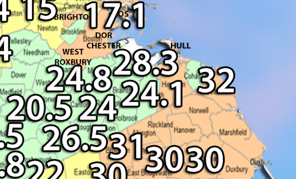
Thats Quincy 1.5SSE cocorahs 24.1 is you
-
hang on i remember that specifically
-
Some are from here but the vast majority are from cocorahs, COOP and climate sites. There's maybe like 20 out of 400 from here on those maps. COLUMBIA 2.6 S CoCoRaHS 18.5" WILLINGTON 2.7 SE CoCoRaHS 18.4" AMSTON 1.7 N CoCoRaHS 18.0" STAFFORDVILLE COOP 14.0" and kevin from here Tolland 15.5" If you have a Mansfield proper snowfall total i can include it
-
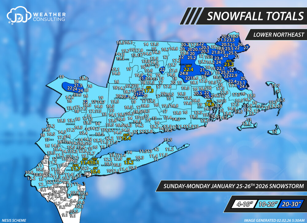
Special Edition Blizzard 2026 Snowfall Maps I do these with the big KU events, just for fun and to see how to compares to actual NESIS maps using the same color scheme and snowfall ranges Lower Northeast Contours Only
-

January 25-26th, 2026 Final Storm Totals
The 4 Seasons replied to The 4 Seasons's topic in New England
Special Edition Major Jan 2025 Snowstorm Snowfall Maps No NESIS map out for this yet unfortunately Lower Northeast Contours Only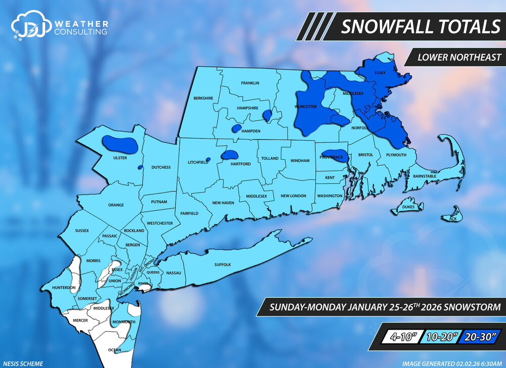
-
Special Edition Blizzard 2026 Snowfall Maps I do these with the big KU events, just for fun and to see how to compares to actual NESIS maps using the same color scheme and snowfall ranges Lower Northeast Contours Only
-
Nice. 1888 was just based on NESIS and COOP data, it's nothing special just had to go off whatever is out there since it's so incredibly old. We were still riding around on horses, wild to think about. Everything was done manually in Photoshop and exported as a jpg. I have that and the original psd file for everything, almost 2k files of each. So nothing is vector based. Thanks for all your help over the years.
-
Epic I just hope we get one good March warning event and push me over 60
-
Okx and box have virtually nothing T-0.5
-
I think the fx is roughly the same as the last one, I just have lower confidence and added marginal temps in SCT makes it harder
-
HRRR is nice
-
"Don’t do it" 2026 Blizzard obs, updates and pictures.
The 4 Seasons replied to Ginx snewx's topic in New England
So where is Jan? Had to be a Cat 3 easy but they still haven't done it? -
"Don’t do it" 2026 Blizzard obs, updates and pictures.
The 4 Seasons replied to Ginx snewx's topic in New England
Still doesn't work, i tried a bunch different sizes from 47 to 45 to 37 to 25mb none of them worked. I tried one from the Jan 25-26th storm that was 18mb and that went through fine. So theres some threshold maybe around 20mb that it doesn't like for some reason. It's all good, thanks for trying. Ill be putting it up on the site anyways, just wanted to post it here Here's the one that went through, 18.2mb -
"Don’t do it" 2026 Blizzard obs, updates and pictures.
The 4 Seasons replied to Ginx snewx's topic in New England
yea just a .gif radar loop -
How did models perform? Was NYC forecast to get an all-timer or was that a surprise positive bust? That snowfall gradient is probably the tightest ive ever seen with just a couple/few inches to 20-30+ over just a few miles. It's their #5 all time snowstorm at 20.9"
-
"Don’t do it" 2026 Blizzard obs, updates and pictures.
The 4 Seasons replied to Ginx snewx's topic in New England
didn't work, i tried two different files one was 45mb and the other was 47mb. Increasing to 100 didnt change anything, same error code. -
"Don’t do it" 2026 Blizzard obs, updates and pictures.
The 4 Seasons replied to Ginx snewx's topic in New England
2010/2011 was the closest with two Cat 3s Boxing Day and Jan 11-12th 2020/2021 had a Cat 2 and 3 2016/2017 had a Cat 2 and 3 2014/2015 had a Cat 2 and 3 2013/2014 had a Cat 2, 2 and 3 I'm curious what Jan 25-26th will end up being. I'm guessing a 4 so might end up being two 4s or a 4 and a 3. That storm was major for most of the United States east of NM/Texas. -
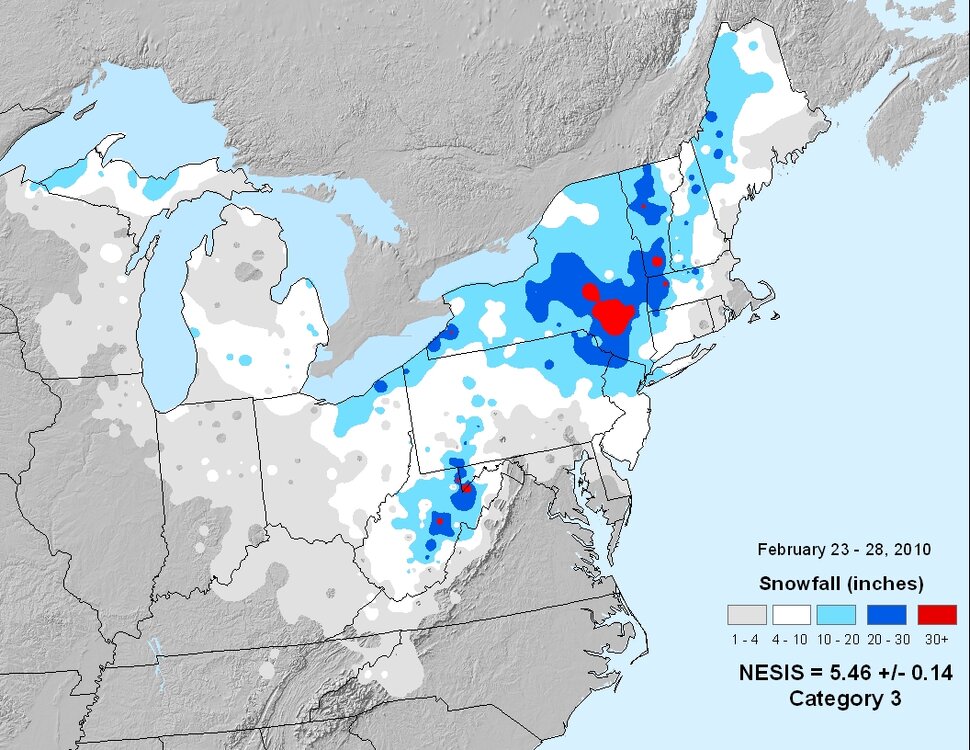
Today (and this week really) is the 16th anniversary of the mega storm of Feb 23-28th. This storm is also referred to informally as the "Snowicane". It came in two parts the first alone was a massive snowstorm for the interior and the second part separated by about 12-18hrs was a huge storm for W SNE and the Tri-State with the most bizarre and anomalous snowfall gradient ever. These two systems were really just one giant storm, a massive cut-off bowling ball just parked over the Northeast for nearly a week. Because the NWS PNS separate this into two separate events i made two snowfall maps for each, it was just easier that way but the NESIS map combines the two. If you add both together you get basically an 1888 type redux for the interior with snowfall totals in the 45-55" range for the Berkshires and Catskills. I think Slide had a total of about 51" for the event and Savoy 55.3". Ill be fixing these and replotting them but haven't got around to it yet. Here's the radar and sfc/h5 maps: https://www.jdjweatherconsulting.com/feb-23-24-2010 https://www.jdjweatherconsulting.com/feb-25-27-2010 February 23-24th, 2010 February 25-27th, 2010 NESIS combined 5-day total
-
"Don’t do it" 2026 Blizzard obs, updates and pictures.
The 4 Seasons replied to Ginx snewx's topic in New England
It'll probably be Cat 3 or 4 if i had to take a good guestimate at it. It won't touch 1993 or 1996 due to it only affecting heavily NJ-BOS. The population area is just too small. 1978 was a Cat 3. 2016 even beat that (Cat 4) because of the DC-NY mega totals. https://www.ncei.noaa.gov/access/monitoring/rsi/nesis Hey @dendritedo you know what "error code -200" is? I was trying to attach a full radar loop of the storm and it's below the max size (which for me has always said 48.83mb). This file is only 45mb but it still wont let me do it, i have plenty of space it just doesn't like the big file size. -
"Don’t do it" 2026 Blizzard obs, updates and pictures.
The 4 Seasons replied to Ginx snewx's topic in New England
you'd have to be reaaaalllyyy short, like a child. Floor to waist area for an average adult male is about 30-36" That pic says it all. And the gas station was actually open to make a chocolate milk run LOL -
"Don’t do it" 2026 Blizzard obs, updates and pictures.
The 4 Seasons replied to Ginx snewx's topic in New England
This is giving that Navy Seal Copypasta.... "What the f*** did you just f***ing say about me, you little b***h? I’ll have you know I graduated top of my class in the Navy Seals, and I’ve been involved in numerous secret raids on Al-Quaeda, and I have over 300 confirmed kills. I am trained in gorilla warfare and I’m the top sniper in the entire US armed forces. You are nothing to me but just another target... You think you can get away with saying that shit to me over the Internet? Think again, f***er. As we speak I am contacting my secret network of spies across the USA and your IP is being traced right now so you better prepare for the storm, maggot. The storm that wipes out the pathetic little thing you call your “life”...." -
i think he was just talking about all the SNE individual maps. I dont have a std new snowfall map done yet, the latest ones are from early feb, Feb 3rd. ill be doing that this week https://www.jdjweatherconsulting.com/winter-25-26
-
Yes, basically anything that triggered a map for the area, which is at least 1" over a portion of the area (SNE, Tri-State). There are plenty of very small squalls or snow shower type events 0.1-0.5 that aren't included so you cant just add up those maps to get a total, but itll give you a very close idea. Also Feb 20th 0-6" gradient event and yesterdays Feb 25th light snow event are not up yet. Those need to be done then it will be complete to date. Other than that it should be up to date.
-
"Don’t do it" 2026 Blizzard obs, updates and pictures.
The 4 Seasons replied to Ginx snewx's topic in New England
I do not but im sure @RUNNAWAYICEBERGand @Spanks45can give you a STD for their town Southbury For the others you can use cocorahs Newtown and Woodbury both have a cocorahs and COOP but may have some missing data, you'd have to check -
"Don’t do it" 2026 Blizzard obs, updates and pictures.
The 4 Seasons replied to Ginx snewx's topic in New England
I was gonna say this is a perfect example of confirmation bias..having a strong opinion and theory beforehand and then looking for data to confirm your beliefs. At the very least its heavily biased and a flawed approach given the time that elapsed


