

burgertime
-
Posts
11,230 -
Joined
-
Last visited
Content Type
Profiles
Blogs
Forums
American Weather
Media Demo
Store
Gallery
Everything posted by burgertime
-
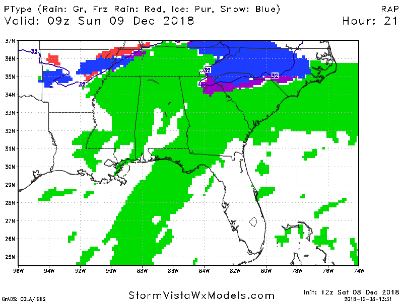
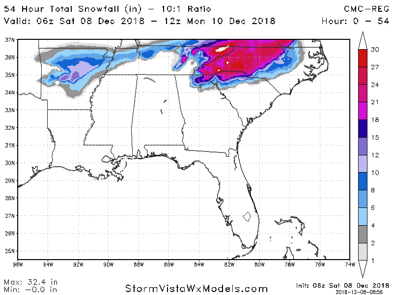
RAP say this is pretty much all snow for all of NC. Someone is either gonna get an epic sleet storm or a once in a life-time snow storm.
-
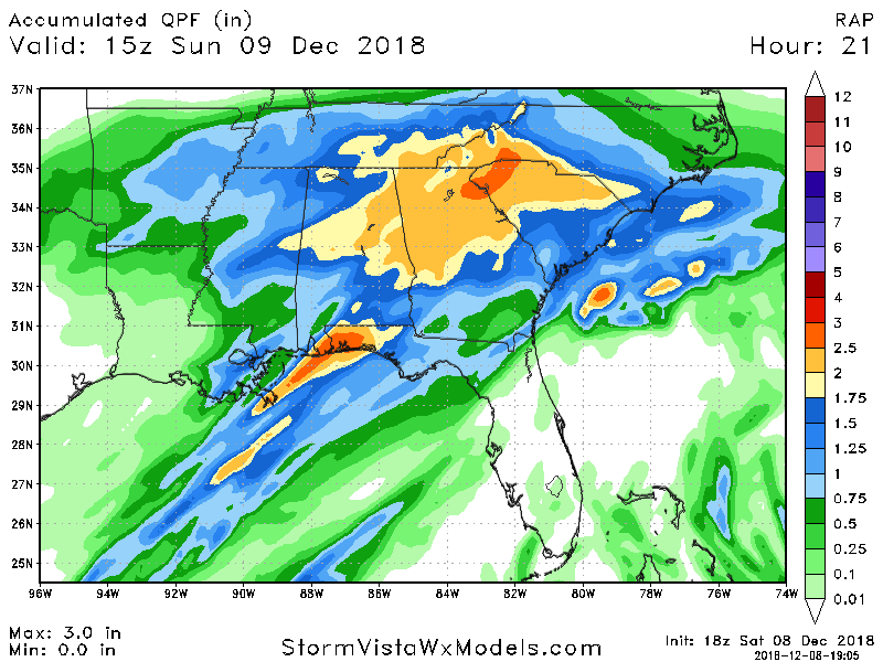
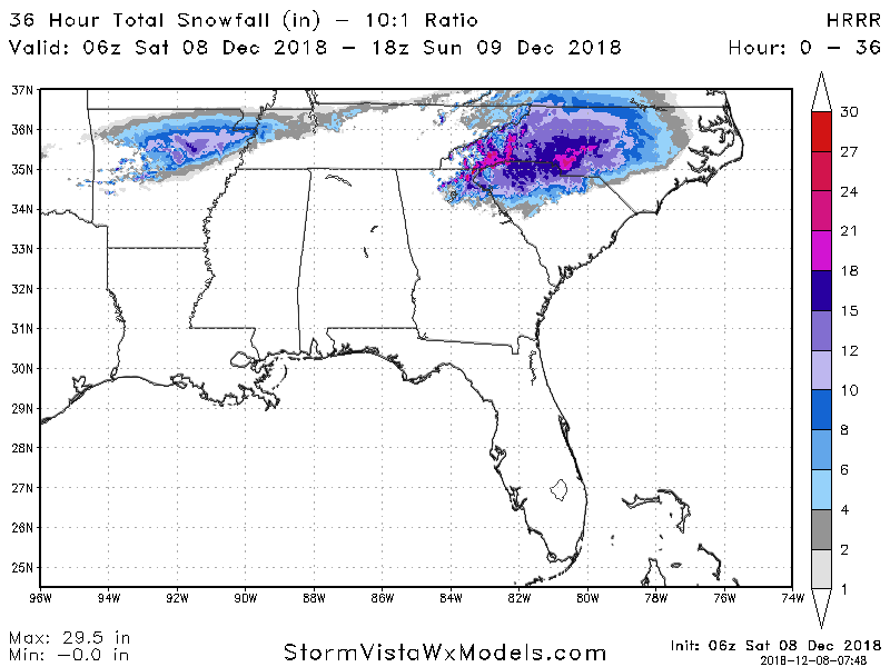
These HRR totals are crazy. On the lates run AVL has almost 15 inches by hour 15.
-
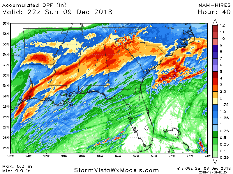
RDU per the Hi-Res NAM would get around a foot of snow before changing over to sleet just based on QPF and p-type maps.
-
If Hi-res NAM is correct verbatim it drops almost 6 inches of snow on CLT before the switch over to sleet. Those would be some seriously heavy rates.
-
Hi-res NAM has all snow for RDU. Battle line for ice is right at CLT and along I-85.
-
Living on the edge my friend....who ever is on the good side of that line is gonna get crushed.
-
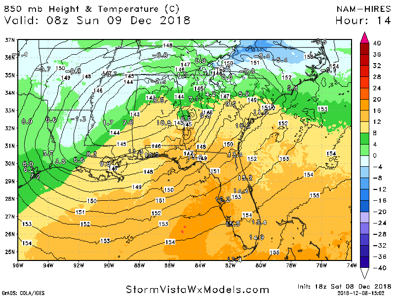
Hi-res looks better for RDU here are 850's at hour 14
-
Doesn't look that bad to me.... sorry yea RDU doesn't do well verbatim but I'm a little skeptical that line is gonna be hard to define.
-
Those are good signs in my opinion as well. Shows that there's good cool air coming across the states.
-
True definition of insanity
-
RAP has all of NC snow.
-
Oh I know what it shows...just with thickness right on the line and that heavy of precip I don't buy it...but I guess if you buy one part you gotta buy the car on these modesl haha.
-
If this much snow falls you're also gonna see temps plummet so anything that fell would stick. It could be an intriguing little bonus.
-
Was really expecting this yesterday to kind of have the final guess locked in. I really think the usual snow starved areas end up doing well in this one.
-
I have a hard time buying that in the the heart of the storm on the NAM Hi-Res that isn't snow in Charlotte.
-
When the air is warmer the temp goes up... seriously though don't fret over this.
-
Could you dream of a better map than this, being this close to the event?
-
A few things for folks south of I-40, I'm typically biased towards the optimistic side (why I'm in marketing and not a scientist). So if you end up with a ton of sleet and go, "but models said" or if you end up with all snow expecting sleet and go, "but the models said".. here is the list of the negatives and positives: Negatives: Statistically, odds are not in our favor for a major winter event in December. It just doesn't happen that much, so first things first we're fighting against climate and history. As @Cold Rain has stated many times we don't have a true polar air mass. So this isn't a situation where moisture is brute forcing it's way into sub-freezing temperatures and snow is a lock. When you have to count on the storm to do the bulk of the dynamic work at the 850 level at game-time it usually doesn't end well for folks from GSP-CLT-RDU. Positives: Wisdom is knowing a tomato doesn't belong in a fruit salad. Wisdom tells us given the factors at play (and GSP/WPC lays it out better than most on here could) the models aren't properly predicting what usually happens. There's just enough cold air to work with it. Even IF the models are right you get a historic storm, it just may end up being mostly sleet Even IF the models are right most should still end up with a few inches of snow which is a minor miracle in early December anyways Bottom line is, more focus will now be on what's happening on the ground and short-term models to better predict how this plays out. There will be winners and there will be losers. A winner or loser may be one county over or just a few miles in one direction. Good luck to everyone!
-
Yep to me that's concerning...however to your point it tends to be a tick better the past two runs. I personally think if you're right on the edge of that 546 line there's enough heavy moisture to overcome it and with winds being easterly and coming from the north that should get it done.
-
Nailbiter as always because that tends to be an on the ground issue. We need @phil882 on the case!
-
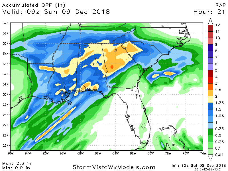
Hi-RES NAM is still pretty crazy with totals...*GULP*...also has it as all sleet for most below 40.
-
If you were to believe the HRRR at the end of it's run. Take with a big grain of salt.
-

Southeast Sanitarium - A Place to Vent
burgertime replied to Jonathan's topic in Southeastern States
I can be one! -
Yea I've been totally out of the mix on how wet it's been there outside of the hurricane. I just figured the models would start getting colder as we moved into it.
-
I was thinking the models would start doing that anyway just because of the setup. I'm leaning more towards that though I'm still sceptical of the QPF totals, but if storms have been overperforming then I guess it's possible. Just so used to those big QPF totals never actually panning out during winter storms in NC.


