

burgertime
-
Posts
11,230 -
Joined
-
Last visited
Content Type
Profiles
Blogs
Forums
American Weather
Media Demo
Store
Gallery
Everything posted by burgertime
-
It's getting back to normal now. Summer was brutal. Interestingly last year the snow threats in NC were mirroring the threats here. Looks like we have a week of moderate temps before the cold comes in, but due to being so close to the sea it takes a bit to get a good snow here.
-
Just being insane and watching from Amsterdam. Much more exciting than the weather here (though we have a few streets that are more exciting than weather). Speaking of updates, I've noticed on my social media feeds my friends seem to have no clue about this storm. Hopefully word gets out cause no matter what it's going to cause major headaches.
-

Southeast Sanitarium - A Place to Vent
burgertime replied to Jonathan's topic in Southeastern States
I mean it's pretty clear now, and the forums are being watched like crazy. Guess the servers have to go down a few times before they pull the trigger? -
My money is gonna be AVL or somewhere abouts there. Thanks for the input, always know it's a fun time when you swing by our neck of the woods
-
Well we know who Virginia is rooting for....I'm ready to see how this battle between ice and snow plays out and where the battle lines are. Also that cutoff on the RGEM is pretty wild.
-
Yea Allan did a good write up on it and I believe you're exactly right.
-
Doesn't appear to be also has a lot to do with orientation...convection can also enhance banding.
-
Just 3 hours ago you were getting upset at RAH for not calling for enough snow. Now you're back to cold rain?
-
I think it shows how the models are struggling with the column cooling. We won't know probably until it's actually falling.
-
Not bad...
-
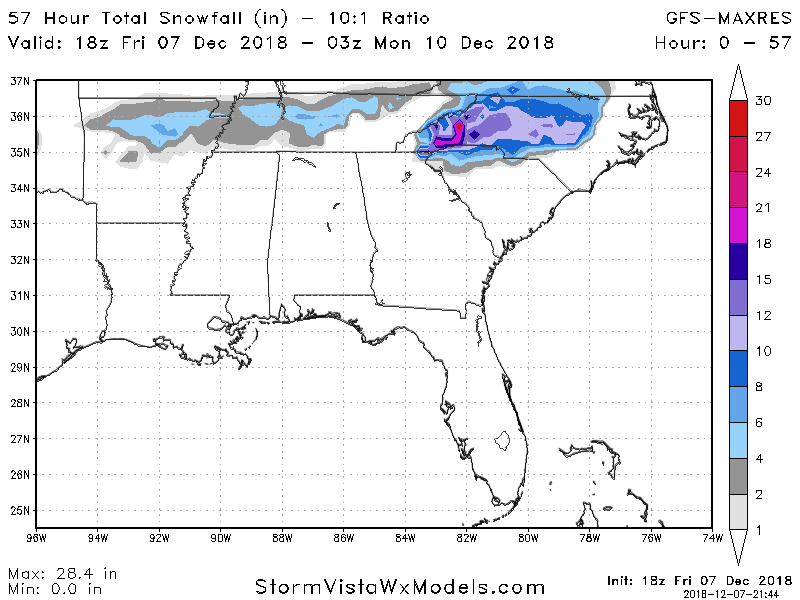
@48 goes BOOM over WNC! Much like 12z. AVL gets demolished.
-
@45 WNC is all snow. Looks great!
-
@42 looks like a little bit stronger CAD helping cool things in NC.
-
At one point it looks a tad warmer then @36 it looks a tad colder...other than that looks about identical.
-
18z GFS is pretty much keeping with 12z out to 24.
-
Southeast Sanitarium - A Place to Vent
burgertime replied to Jonathan's topic in Southeastern States
How in the world are we not in storm mode? -
RGM says "Hold my beer"...
-
Look at thiiisssssss..... https://i.imgur.com/rrCa00h.gifv
-
3KM is pretty much all sleet for the duration of the storm there so totally possible.
-
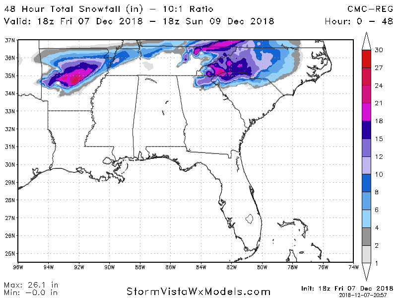
NAM was not a bad look at all with the track of that low....There could be a good amount of snow as it goes up the coast and out to see. It's never easy lol.
-
Bulk of moisture is also pulling out @51...like all storms it's never easy.
-
@51 pretty much everyone from GSP to CLT to RDU is in on the game!
-
I'm sort of hoping that with so much heavy precip the models just really aren't picking up total column cooling. Either way gonna be a look out the window and see situation.
-
Whatever happens whoever gets all snow is just going to get crushed. AVL looks to get demolished on this run. GSP probably also cashes in.
-
Yep this thing is juiced!


