burgertime
-
Posts
11,230 -
Joined
-
Last visited
Content Type
Profiles
Blogs
Forums
American Weather
Media Demo
Store
Gallery
Everything posted by burgertime
-
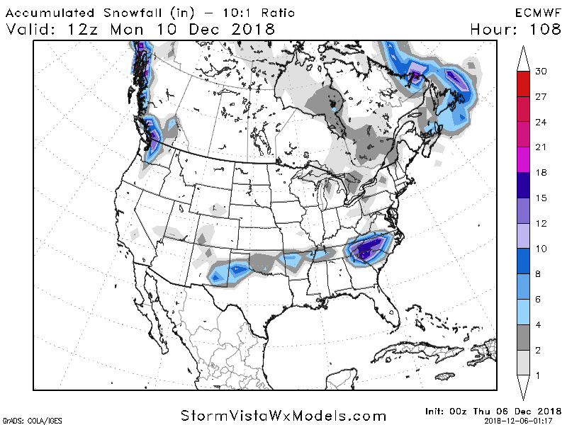
This run is colder...not gonna be cold enough for people but this run of the NAM is pressing that cold Canadian air down a little more. We need to watch this trend. @45 I-40 north is the 0c line. On the 00z it was along the VA border.
-
Should see snow breaking out along I-85 and parts of 74 by 00z Sunday.
-
Colder on the NAM @42 for NC.
-
Yea just got to see the maps from the 00z runs. This was my first worry was that it's still early December. Anyone south and east of 40 always gets the warm nose. I still feel like the models are kind of doing weird things. Also this will be the storm that trends warm than somehow over delivers just to make even more people confused here.
-
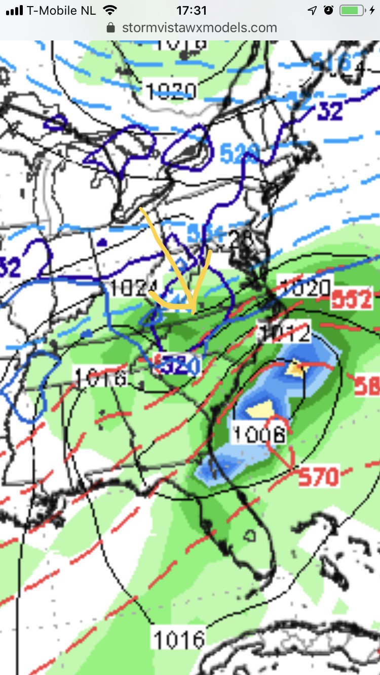
Yep and you can see this on the models. I've found that thickness is a good way to spot ice/rain. You want to be above the 540 line or between it and the 546 because as it cools the column you get sub 540. What you don't want are those red lines stacking on you. It'll be ZR every time and if you're at 546 it's usually sleet. In this case CLT is on the line but with that 850 line well south I'd take my chances that mother nature does the rest of the work. Sorry for the crude drawing. On my phone right now.
-
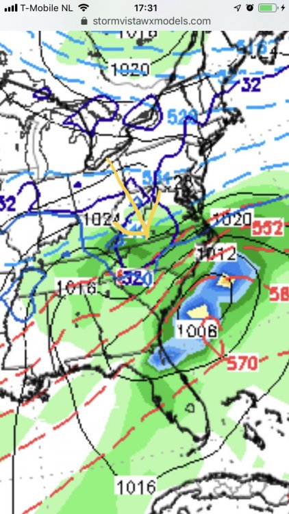
I was just coming on here to say this. 850 line in a good spot south of CLT, good temps aloft during the heavy stuff. Sfc temps were bad for folks south of GSO but they always are around this time on the models. Storm can still go to the crapper but it isn't that far off from its past runs.
-
Fixed that for you
-
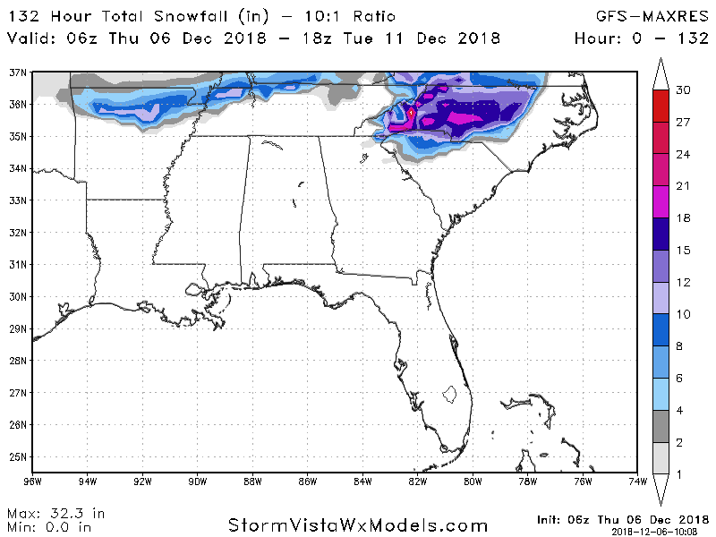
Unless we see some drastic changes we just have trust what conventional wisdom tells us in these situations. Obviously north of I-40 is in the best spot for all snow, but no need to do any cliff jumping. Again even if you cut these totals in half that still a big snowstorm for EARLY december.
-
6z still looks good though our temps still hang in the balance verbatim.
-
Yea looking at the models I feel the same...Given the high pressure cutting across the lakes and the confluence in the northeast I have a hard time buying that low tracks much north.
-
Yea this one was def more a southern slider as Grit alluded too.
-
Just outside of it. Can't emphasise enough though that no one should be focusing on absolute totals right now. Long ways to go before we figure out winners or losers with these huge totals being shown. Verbatim the Euro was big ice storm for CLT...but wisdom says there would be more snow for a lot of NC. Need to see the Bufkit data.
-
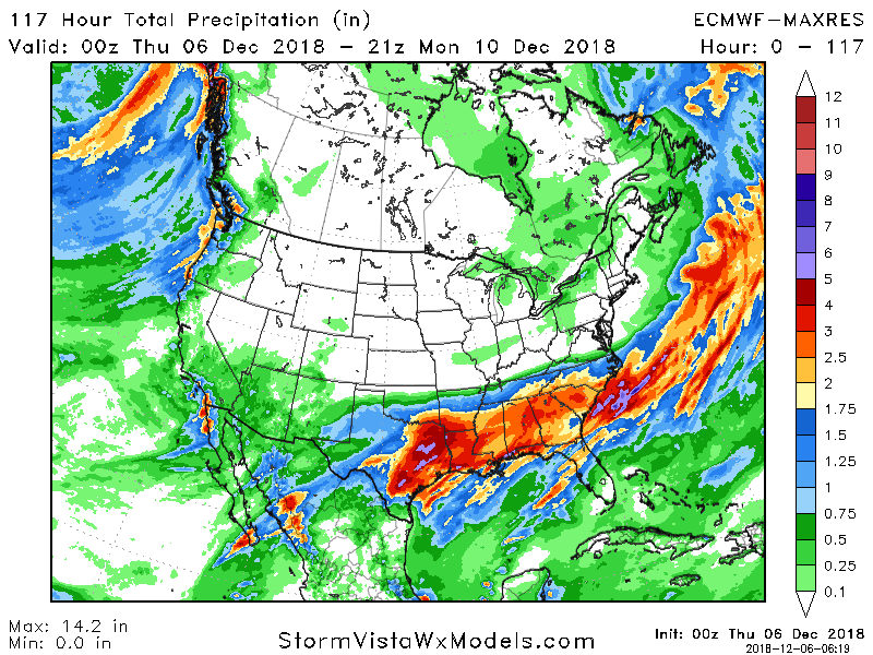
Here's how the precip looks....Also is anyone using the 18z and 6z runs of the Euro? Just wondering how they stack up to the NAM.
-
I'm a little confused how TN doesn't get more out of this system with the look on the Euro tonight. I figured they would be the max on this run.
-
Look where the red dot is
-
It isn't nearly as tasty as the 00z run on the backside though. Temps go up and we get hit with rain outside of the mountains...again verbatim. This is a tricky little run this go round. I think it's also seeing the WAA coming now.
-
Between 87 and 96 model goes BOOM! This is a crush job especially for WNC and TN really gets pounded. Colder than the 00z run. I would be getting the supplies ready. Also someone is going to get a BAD BAD BAD ice storm out of this.
-
@81 all hell is breaking out in NC. Def. colder this run as the Euro is picking up on that CAD signature. Verbatim it's ice across the much of the region outside of I-40 west.
-
@72 things are starting to take shape. A few changes but to my eye it looks a tad colder than the 00z run. Low is closed off in Texas...this doesn't look quite as wet in LA but again not so much of a difference it's alarming or anything.
-
Out to 42 on the Euro...pretty much holding serve with 12z. A few subtle changes but nothing to write home about yet.
-
I answered above. We do have somethings going against. Climo being one...but like alot of storms in your neck of the woods you gotta look at the models and roll the dice. The setup is what you want. Lots of moisture and a good enough cold air feed. Like I said this feels less like a true Miller A where it really bombs out on the coast and more like a slider that takes a Miller A track...again if that makes sense. Maybe I'm wrong though about that assessment. I still am a bit sceptical on totals but even if you slice them in half it's still a significant possibly historic storm.
-
This to me isn't your standard Miller A it's taking that track but it's more a big overrunning event taking a Miller A track...but maybe I'm wrong with that. If this follows the models like GSP said it's historic. That's the thing about making history, there's nothing to really compare it to.
-
Yep. Also a lot of moving parts. The good news is the big models are still holding serve so people should be using that as a guide not an exact map. The players we want are there, now it's just going to be how they all align.
-

Southeast Sanitarium - A Place to Vent
burgertime replied to Jonathan's topic in Southeastern States
I'm asking myself that John . I have a company Christmas party tonight and other than that a long weekend. So might as well do something fun? Plus once I saw the models I got sucked in. Hard not be excited even over here! Hope all is well with you! Thanks for the kind words. That's how you know it's a great community here. Even the ones who leave keep coming back...or is that a cult? -
Southeast Sanitarium - A Place to Vent
burgertime replied to Jonathan's topic in Southeastern States
Dude of you come def let me know! You're welcome to stay with me and use it as a base. I really want to be in the Marijuana biz so I could see moving back for that but I am really happy here and I'm working on another project in the UK outside of my normal job. So for The next two years I feel like I'll be here and thinking about buying a place. Problem is no one knows what's going on with Brexit. You are right about the summers though. This Summer was too hot...it was nearly 90 most of the summer with a few days topping close to 100! Maybe it's because of the winter but when it's nice out everyone is out at the park or doing something outside!