

burgertime
-
Posts
11,230 -
Joined
-
Last visited
Content Type
Profiles
Blogs
Forums
American Weather
Media Demo
Store
Gallery
Everything posted by burgertime
-

January 30th- Feb 1st ULL and coastal storm obs
burgertime replied to JoshM's topic in Southeastern States
My brother has around 5 inches in Shelby. -
January 30th- Feb 1st ULL and coastal storm obs
burgertime replied to JoshM's topic in Southeastern States
I also think you'll be fine. It's always like throwing darts where the heavier bands setup but you should get 6+ I would think. -
January 30th- Feb 1st ULL and coastal storm obs
burgertime replied to JoshM's topic in Southeastern States
Good luck on the snow everyone! I'm watching jealously from afar. -
The “I bring the mojo” Jan 30-Feb 1 potential winter storm
burgertime replied to lilj4425's topic in Southeastern States
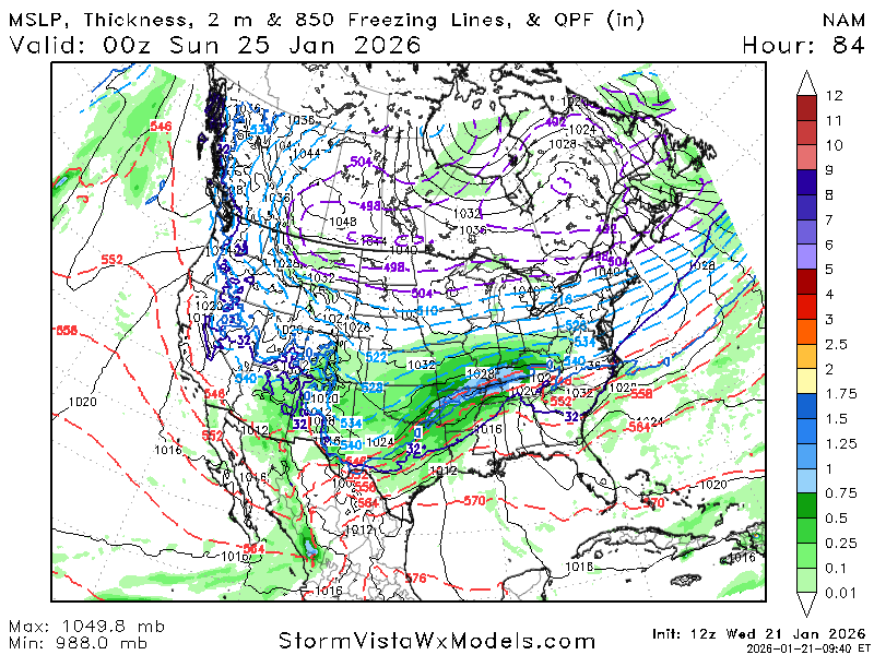
Out to 84 NAM is a crush job for north eastern NC. It is the 84 hour NAM so huge grain of salt. -
The “I bring the mojo” Jan 30-Feb 1 potential winter storm
burgertime replied to lilj4425's topic in Southeastern States
It should be enough -
The “I bring the mojo” Jan 30-Feb 1 potential winter storm
burgertime replied to lilj4425's topic in Southeastern States
Out 78. CLT and eastern NC are big winners -
The “I bring the mojo” Jan 30-Feb 1 potential winter storm
burgertime replied to lilj4425's topic in Southeastern States
The NAM out to 66 -
It's close. It's seems like they keep sniffing around that idea today. Will be curious if the 00z runs have any surprises..
-
Yea for sure. Those runs tomorrow should be interesting if this keeps it up plus the new recon ingest.
-
Not much changed in the 18z NAM at the end though it is a tad colder.
-
NAM should be better. More seperation with the streams at 5H out to 60
-
Here's the difference at 5H between the two https://jumpshare.com/s/TybL8AVKkMqaIOX4t3Ev
-
18z NAM has the energy weaker in Canada compared to 12z and not as far south out to 45
-
Unfortunately I'm headed to dog training so can't do a pbp
-
Candian is a double barrel low ZR nightmare for most of the SE.
-
This is the GFS.
-
Sorry meant for NC should have clarified. GA and points south are ZR. Middle TN gets a great snow on the backend.
-
At 5h GFS is more neutral tilt and sends a big round of ZR at hour 111.
-
12z GFS looks like a few inches of snow up front then a massive sleet fest with ZR after.
-
Very good post! That's also a likely scenario.
-
No argument there. This was for sure a let down on the run.
-
Not sure if the models have improved that much since back in the days when you would get a classic CAD event that was more snow than ZR but to me it looks like one of those types of storms. That Jan 2010 storm was a similiar setup but without the true arctic air mass that this one has. Friday I'd be watching things out west closely.
-
You can see up along Canada and in NY we have strong highs there with arctic air. That should be a good cold CAD event for a widespread area.
-
Yep it's looking like the Euro. Sending the bulk of the moisture up the west side of the apps. It is 84hrs on the NAM but yea not the right direction at all.
-
That energy in the north is coming down faster than the Euro. It had it in Canada at 69hrs on the 6z Euro and just touching Idaho at 72. At 72 on the NAM it's diving through Idaho.


