-
Posts
11,230 -
Joined
-
Last visited
Content Type
Profiles
Blogs
Forums
American Weather
Media Demo
Store
Gallery
Everything posted by burgertime
-

Potential 1/28-1/30 2022 winter storm
burgertime replied to Prismshine Productions's topic in Southeastern States
It didn’t look too bad at 5h just came out drier on the sfc…which given qpfs are usually overdone it could be more realistic. -

Potential 1/28-1/30 2022 winter storm
burgertime replied to Prismshine Productions's topic in Southeastern States
You're welcome. Hopefully, you all can cash in! -

Potential 1/28-1/30 2022 winter storm
burgertime replied to Prismshine Productions's topic in Southeastern States
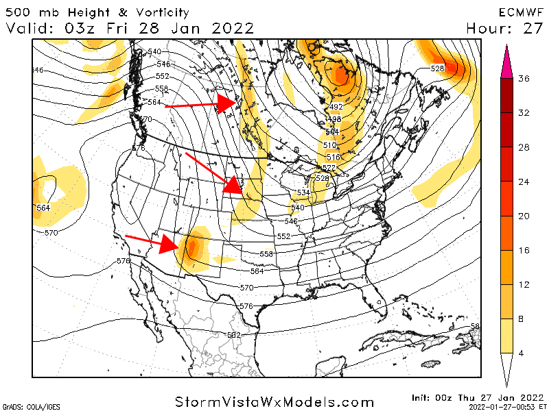
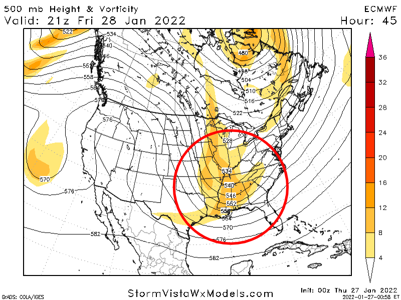
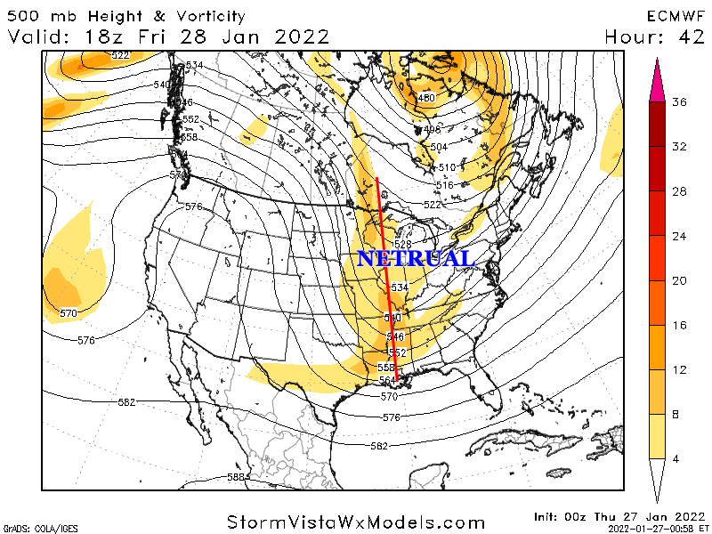
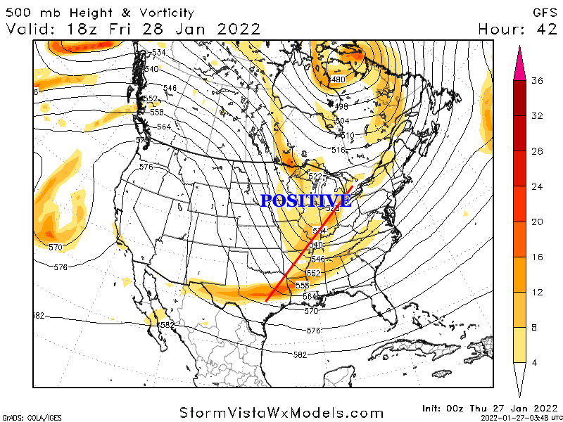
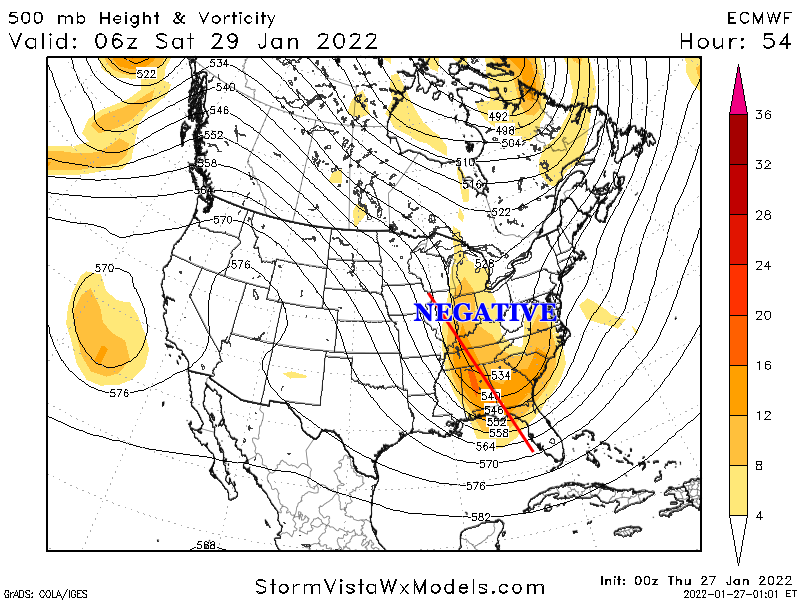
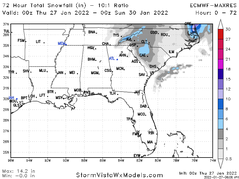
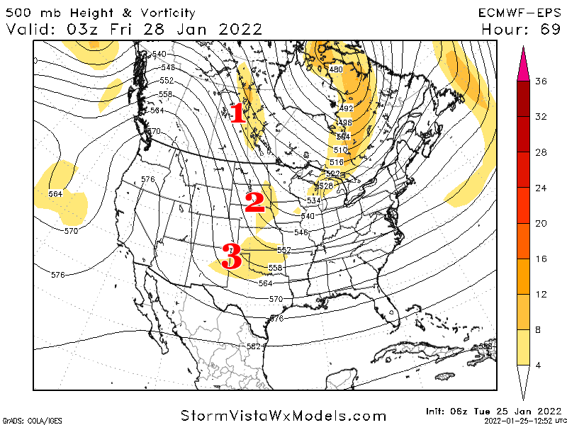
For those still learning and getting confused on what to look for etc.. Euro/NAM is really exciting because it does a big phase which will typically create dynamic weather across a large portion of the southeast. 00z Euro and the NAM tonight really do something special. So what is a phase? Let's use the 00z Euro run tonight to paint the picture: You can see on the map below there are three pieces of energy floating across the US. If these stay as they are essentially separate from each other you end up with small storms across small pockets of the states. What we want to see is these three pieces doing the magic dance and combining to form one big piece of energy like the second image. Past runs across models have shown this happening so, what's different? The problem is that previously this phase was staying positively tilted or neutral. When we say "positive tilt", "neutral tilt" and "negative tilt" what do we mean? This is the orientation of that energy. The Euro and NAM have it go neutral early vs. the GFS. This is an interesting song where if it goes neutral to negative just in time you can get a bomb. When a storm is positively tilted it can push moisture too far south. If it's negative it can pull moisture up. The Euro goes negative just in the nick of time. But what we want to see is for it to go negative just a tick earlier. You can see below all that deep orange and red below. That is a lot of energy which should create dynamics conducive for snow across NC. All and all this could be a big surprise if we keep seeing these trends. This has always been reliant on a perfect phase and it's pretty damn close. -

Potential 1/28-1/30 2022 winter storm
burgertime replied to Prismshine Productions's topic in Southeastern States
Yea I really like this look. Where that pops would be anyones guess but this would work for a lot of folks in NC. I’m rooting for NAM/Euro solution at 500mb tonight. That’s a really good phase. -

Potential 1/28-1/30 2022 winter storm
burgertime replied to Prismshine Productions's topic in Southeastern States
Euro tends to handle these phases better too. This all going to come down to perfect timing but it’s looking like the 4qtr miracle for NC. -

Potential 1/28-1/30 2022 winter storm
burgertime replied to Prismshine Productions's topic in Southeastern States
Here’s how the sfc looks… -

Potential 1/28-1/30 2022 winter storm
burgertime replied to Prismshine Productions's topic in Southeastern States
Euro has entered the chat…this is well…umm interesting. 500mb says this would probably be better on the sfc for ENC than what this map is showing. The rollercoaster continues. Wow. -

Potential 1/28-1/30 2022 winter storm
burgertime replied to Prismshine Productions's topic in Southeastern States
Euro isn’t bad looking at all. This is a pretty good phase here. -

Potential 1/28-1/30 2022 winter storm
burgertime replied to Prismshine Productions's topic in Southeastern States
Problem for folks around the CLT and CNC area I see is that this relies a lot on producing enough moisture as it pulls away. Always a tricky situation which is why you really need a good phase and for that low to bomb out. Usually these just leave most high and dry. -

Potential 1/28-1/30 2022 winter storm
burgertime replied to Prismshine Productions's topic in Southeastern States
It's not terrible but not great either. Snow showers across much of the state maybe a few places in ENC get 2+ inches. -

Potential 1/28-1/30 2022 winter storm
burgertime replied to Prismshine Productions's topic in Southeastern States
-

Potential 1/28-1/30 2022 winter storm
burgertime replied to Prismshine Productions's topic in Southeastern States
12z GFS doesn't look like it'll get it done. Energy in the west is slower. Once it phases it gets all strung out out. -

Potential 1/28-1/30 2022 winter storm
burgertime replied to Prismshine Productions's topic in Southeastern States
That's why we always have to bring up 93, 96 or another rare storm cause it almost never happens. Like @Bevo and others have said these almost always end up working out for the NE and rarely workout for the SE. -

Potential 1/28-1/30 2022 winter storm
burgertime replied to Prismshine Productions's topic in Southeastern States
Things working in SE favor with this storm: Favorable pattern. Storms tend to repeat when you have a good pattern Pattern seems to be dissolving soon and good storms can often come at the end and start of the pattern Euro seems to be holding serve with the big dog solution Things not working in the SE favor with this storm: Reliance on a big phased solution (see image below) Cold 850's but SFC temps need perfect timing WITH a big phase It's the southeast -

Potential 1/28-1/30 2022 winter storm
burgertime replied to Prismshine Productions's topic in Southeastern States
This is thread the needle situation so let the teeth gnashing commence. Problem with relying on super phases is that they almost never pan out. Euro may be on to something but GFS seems like a more likely outcome. Of course I've been wrong 1000x so take what I say with a grain of salt haha. -

January 20-22 “bring the mojo” winter storm threat
burgertime replied to lilj4425's topic in Southeastern States
Good post. Also, often models will show backside snow because it has difficulty seeing when the moisture exits. In a lot of cases it sees the warm nose go, thinks there is still moisture and shows phantom snow. Depending on where the OP is located though it could legit turn to snow. But this will be good experience for a lot of posters to see how this storm unfolds. -

January 20-22 “bring the mojo” winter storm threat
burgertime replied to lilj4425's topic in Southeastern States
I would say yes, but some of the short range modeling is coming in dry as well so it's really anyone's guess at this point. Also RDU east has the best shot it looks like. -
Won't be around today as I have a busy weekend with the girlfriend. One thing to look for is convection in the gulf with this storm. It looks to me based on GFS and short range models that it might be enhancing convection which could pump more precip into the area than expected especially points around CLT and just east. I fully expect the precip shield to be further NW than expected. If I'm in RDU I'm licking my chops right now. good luck to everyone and hopefully it overproduces!
-

January 20-22 “bring the mojo” winter storm threat
burgertime replied to lilj4425's topic in Southeastern States
6z GFS has CLT dangerously close to getting in the 3-5 inch range now. -

January 20-22 “bring the mojo” winter storm threat
burgertime replied to lilj4425's topic in Southeastern States
With these southern slider solutions the models almost always underdo that precip field. This is still a unique setup though in that you have such cold dry air so any ones guess how much is eaten up say around GSO and CLT. It does feel like now the GFS and RGEM are right and it’s a nowcast for how good our energy does. Do not be shocked if somewhere just east of CLT and GSO gets a good punch and this overperforms. -
Def an interesting take. Let's say you become a billionaire. How much would it cost to create a weather model that could rival the Euro or GFS? Wouldn't you also need agreements with governments to get ingest and satellite data? I'd imagine that would be a very very hefty price tag with a lot of red tape just to even get started. It's inevitable though as our climate changes and more catastrophes happen. More money will pump in from the private sector. If my business makes it big I'd def be up for helping fund something like this.
-

January 20-22 “bring the mojo” winter storm threat
burgertime replied to lilj4425's topic in Southeastern States
18z GFS isn't as wet but it did look a tick better with the phasing to me. -

January 20-22 “bring the mojo” winter storm threat
burgertime replied to lilj4425's topic in Southeastern States
Biggest factor is the phasing of energy. NAM just doesn't get it done. -

January 20-22 “bring the mojo” winter storm threat
burgertime replied to lilj4425's topic in Southeastern States
SREF isn't that bad looking for NC. Most of this moisture is snow.


