Chinook
-
Posts
10,933 -
Joined
-
Last visited
Content Type
Profiles
Blogs
Forums
American Weather
Media Demo
Store
Gallery
Everything posted by Chinook
-
Overlay of 700mb winds/temps/RH for a time frame likely the middle of our storm
-
I guess the 500mb predictions changed just enough overnight to have 4 major models predict a bunch of snow for NE Colorado. I don't know if the big change will really be accurate.
-
GFS/Canadian/UKMET have seriously changed
-
I am in Ohio. Rain changed over to big flakes just a short while ago! I'm east of the "red blob" at Fort Wayne (high reflectivity due to partially melted snowflakes) Rain was changing over to snow in Toledo and southward to Findlay.
-
It's definitely going to get colder at that time, with a chance for snow on 12/31 and 1/1. It is most likely I will be back to my place before the colder weather hits, so that will be nice. Who would have ever thought I would have to wait until (maybe) Jan. 1 or later to see just 1" of snow in Fort Collins or Loveland? I've seen rain twice since I've been in Ohio. It seems so strange to have a wet muddy lawn, wet roads, or fog. I saw a tweet that a University of California research station at the high Sierras has 155" for the month.
-
There has been a squall in western Colorado, with various measured wind gusts of 45mph to 80mph in the snow. Temps are slightly above freezing at Rifle and Grand Junction.
-
I got my flight back from the Midwest on 12/30, but I don't see any precip on the models, east of the mountains, yet. Definitely some interesting things at 500mb in the West, though. Apparently Fort Collins-Loveland reported -RA today, certainly weird for December. Lots of precip happening in the Southwest today, with over 1" of rain reported in and around Phoenix.
-

Winter 2021-22 Short/Medium Range Discussion
Chinook replied to Chicago Storm's topic in Lakes/Ohio Valley
I have been checking the weather forecasts in the Midwest, since I will be in Ohio. I am about 99% sure that I will see a raindrop, the first raindrop I will have seen in months. Or maybe even a snowflake. In fact, the Rocky Mountains look pretty gray. I checked the 18z GFS and 12 ECMWF for Christmas day, and they have a bigger disagreement in WI/MI. The 12z GFS and 18z GFS go up above 6" of snow (0.6" of QPF) for mid-Wisconsin and mid-lower Michigan. The ECMWF has much less, about 1" of snow (0.1" of QPF) for just a bit of Wisconsin, and the surface low pressure is less amplified. -
Good point. We've definitely had some much lower temps in late January, but there's just enough warmer downslope days to balance it so it's just a slight bit warmer in the averages in late January. I'm going to see rain soon, but not here.
-
Fort Collins and Loveland today were up to 53-60 degrees, with 61-65 at Longmont. If you look closely at the average temperatures, the days of Dec 20-21 is on average the coldest in our area. Apparently, the lowest amount of sunlight directly correlates to the lowest climate-average temperature. So were were about 13 degrees above average for the high temp, given a value of 56 vs 43. In the East, where I used to live, the lowest average daily temperature was on Jan 19 or Jan 20th, as colder air is always kind of hanging around many days after the Winter Solstice.
-
improvements in West Coast - intermountain West snow basins. 56% to 79% for Upper Colorado River.
-
In town in Loveland got peak gusts just over 50mph, but there was a peak wind of 79mph next to the foothills. I didn't watch it a lot. It was a crazy day to watch some storm reports across the country, like 463 convective storm reports, hundreds of non-convective wind reports, and spreading wildfires and dust storms. There was a "Fire Warning" for Russell, Kansas. I hope it didn't hurt anybody! As mentioned before the "PEAK GUST 75" at Broomfield-Jeffco does translate to 84mph!
-
December 15th-16th Warmth, Wind, and Severe Threat
Chinook replied to Geoboy645's topic in Lakes/Ohio Valley
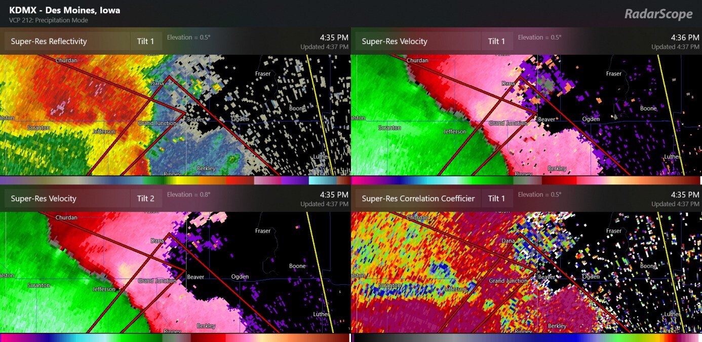
likely TDS close to Jefferson IA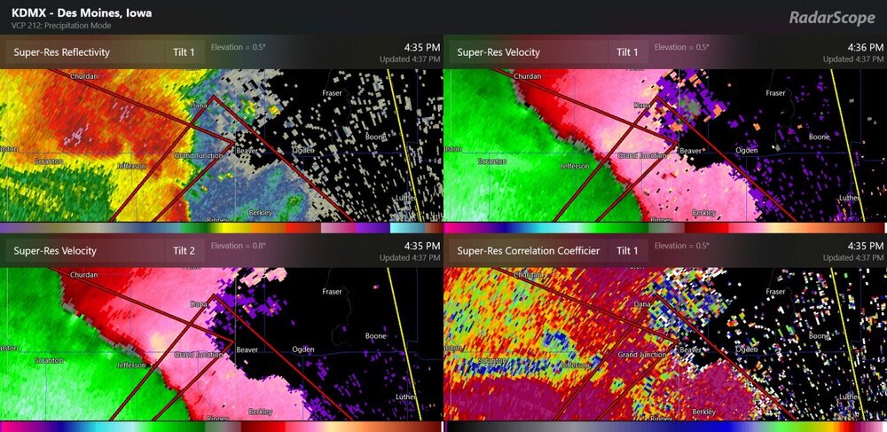
-
There are already a few isolated hurricane-force wind gusts at KBJC (near Boulder), west Loveland mesonet station, and near Colorado Springs and near Pueblo. KBJC 151745Z 27056G73KT 10SM BKN065 BKN085 07/M14 A2924 RMK PEAK GUST 75 KBJC 151700Z 27035G53KT 10SM BKN065 OVC085 05/M09 A2926 RMK PEAK GUST 70 KBJC 151647Z 32024G41KT 10SM SCT026 BKN065 OVC085 06/M07 A2930 KBJC 151630Z 32024G41KT 10SM SCT026 BKN065 OVC085 06/M07 A2930 KBJC 151547Z 31012G21KT 10SM -RA SCT026 BKN065 OVC085 05/M02 A2933 KBJC 151515Z 28018G35KT 3SM -RA SCT007 BKN012 OVC048 04/00 A2935 KBJC 151445Z 28035G50KT 3/4SM RA OVC012 07/00 A2935
-
I have finally done it. I have made an animated GIF of the HRRR model cross-section prediction of winds. The high winds, above hurricane force (purple) will develop in and above the mountains next to Boulder and work eastward and downwards. This could give hurricane-force gusts to Boulder, and then weaken, as the high wind sector seems to fade out. As you can see, varying winds above gale-force (green) to 50kt (orange) are just above ground for eastern Colorado
-
A high wind watch issued for much of the Plains, sections of NM, AZ, UT, and WY. Winds of 30kt to 70kt winds will exist at 1000m (or 3000ft) above ground in eastern Colorado on Wednesday
-
Mid-Iowa might be the warmest relative to average. Here is some discussion from DMX
-
3 out of the top 5 analogs have some version of a severe weather event.
-
Good news. The Canadian, UK, and ECMWF have shifted back to give Larimer/Boulder counties some snow on Thursday night/ Friday. The GFS still pretty much has small stuff for Denver to Cheyenne. I don't know if this trend will continue. The forecast inconsistency is still pretty annoying for the most populated areas right now.
-
We've got a December tornado warning on the mid-Mississippi River near Cape Girardeau, MO.
-
--- and that's why I didn't post a snow or QPF map last night quick temp drop at Greeley, Fort Collins, Loveland, not really lined up with any clouds on the satellite map. My place dropped off from the 60's to the 50's very recently. Edit: Fort Collins dropped from 61.8 to 32.4 in 2 hours. Edit: Loveland mesonet station dropped from 65 to 24 in just this afternoon to early evening.
-
Loveland, Route 34? It really has been a nice time to get outside and do some walking and jogging, and get going in the morning without having to scrape off a ton of frost or snow. But it does look like winter is coming. Tomorrow, shallow cold front will move in to the I-25 area from the east, and it will stay. The 30-degree cold air mass will be in northeast Colorado for Monday. Most likely, there will be a significant storm at the end of the week. The models have some consensus that the upper level trough will drop down from the Pac NW on Thursday to Utah on Friday, with significant snow possible for Nevada, Utah, northern Arizona, and western Colorado. As for the Plains, today's models have variable predictions of QPF for Larimer County, SE Wyoming, and western Nebraska. That, is, of course, the main question. It is 6-7 days away, so I guess we won't know yet. This upcoming storm will obviously bring a significant increase in snow cover over 9000 ft. and here's something you might not want to see
-
The models are consistent with a low pressure in Colorado on Tuesday. So far, no models are showing much precipitation. Today's models have a large storm for next Fri-Sat, so that is definitely something that could be discussed over the next week. Today's ECMWF has 987mb near Colorado Springs next Friday and snow at Denver.
-
record breaking in Montana
-
11/29