Maestrobjwa
-
Posts
12,125 -
Joined
-
Last visited
Content Type
Profiles
Blogs
Forums
American Weather
Media Demo
Store
Gallery
Everything posted by Maestrobjwa
-

2026 Mid-Atlantic Severe Storm General Discussion
Maestrobjwa replied to Kmlwx's topic in Mid Atlantic
I thank you for that and those links with great info and visuals--it's already starting to make more sense. Just that lottle hit goes a long way- 1,694 replies
-
- 1
-

-
- severe
- thunderstorms
- (and 7 more)
-
2026 Mid-Atlantic Severe Storm General Discussion
Maestrobjwa replied to Kmlwx's topic in Mid Atlantic
Bed? Gufaw...I don't go to bed till 3 am buddy so I got 4.5 hours So rule of thumb for the forum all ye laymen...don't ask any questions--Google But honestly, though...a glossary of abbreviations would help as well. I may start a thread and folks can add to it (though it does seem like someone in another thread did something similar but not sure where it was) -
2026 Mid-Atlantic Severe Storm General Discussion
Maestrobjwa replied to Kmlwx's topic in Mid Atlantic
Wow. Man I still don't fully understand what CAPE is, admittedly. I mean I see it's important for severe--what does it stand for? (Before someone sarcastically tells me to Google it I at least gotta know that, lol) -
2026 Mid-Atlantic Severe Storm General Discussion
Maestrobjwa replied to Kmlwx's topic in Mid Atlantic
Bruh...still having thunder and lightning with this train! -
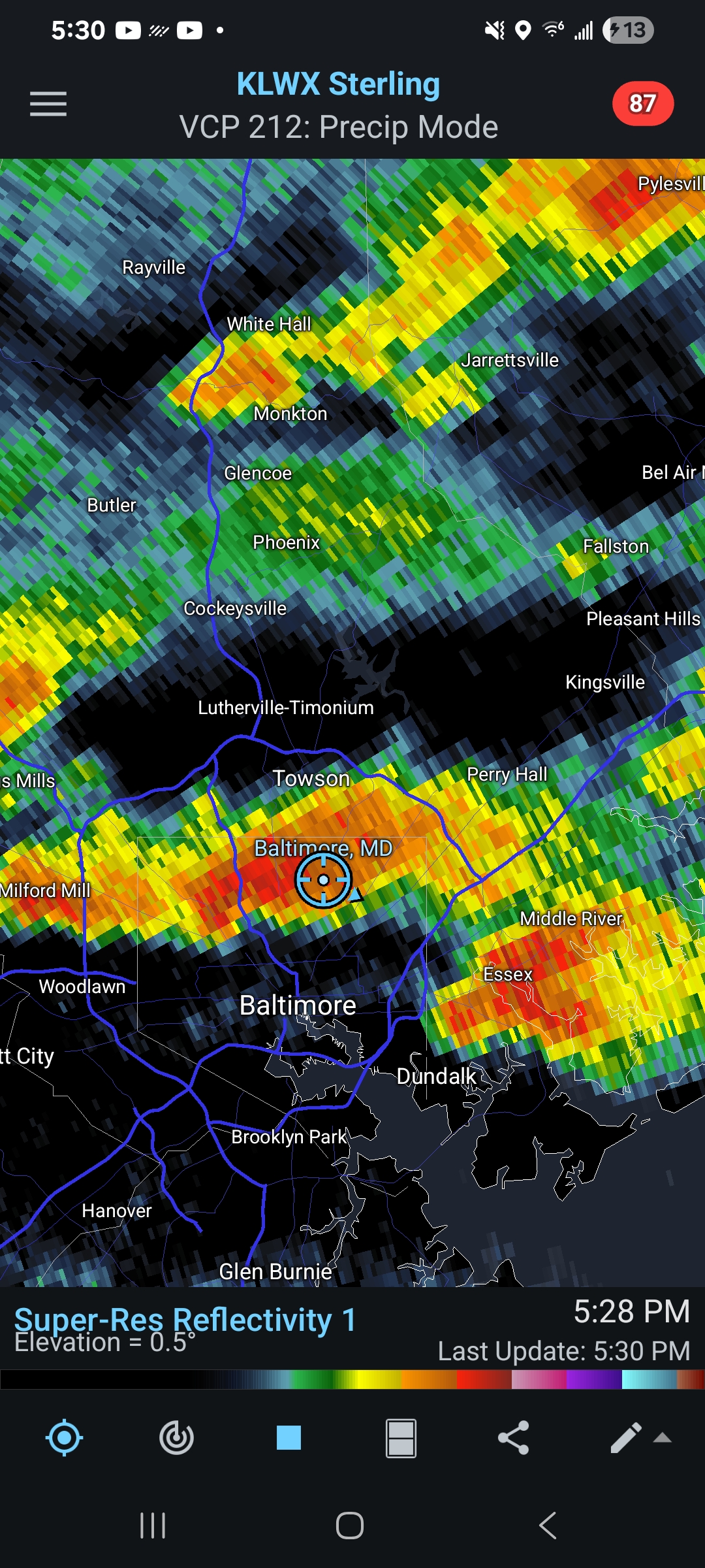
The clusters of slightly more severe storm that came right over the area earlier combined with this train have resulted in quite the soaker here in northern Balt. City...probably been a couple years since we had this much at once--much needed, I'm sure! Training and training along right now, lol
-
The clusters of slightly more severe storm that came right over the area earlier combined with this train have resulted in quite the soaker here in northern Balt. City...probably been a couple years since we had this much at once--much needed, I'm sure! Training and training along right now, lol
-
2026 Mid-Atlantic Severe Storm General Discussion
Maestrobjwa replied to Kmlwx's topic in Mid Atlantic
What exactly is that? -
2026 Mid-Atlantic Severe Storm General Discussion
Maestrobjwa replied to Kmlwx's topic in Mid Atlantic
Solid downpour here in the city. Definitely hearing thunder! Looks like I happened to get under a dot, lol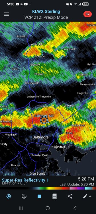
- 1,694 replies
-
- 1
-
-
- severe
- thunderstorms
- (and 7 more)
-
Not giving me hope in the slightest...we know who this team is--and there has been a good deal of luck involved (especially yesterday and Friday( I did not see enough to convince me they're suddenly getting better. And not ot mention we may need to play Boston with Adley and Basallo less than 100% if available, smh This team cannot have good things--everytime something good happens, some negative (typically in the form of an injury) has to happen. 7-game winning streak, extended Bradish...then boom catching duo both injured. That bad "luck" element I put on Elias...I don’t think that will change until he's outta here, lol
-
Because of Elias/Sig philosophy. Their overuse of analytics, and not enough focus on fundamentals and actually having a winning mindset throughout the organization (major and minors) is a big problem. The fact that Cal has stepped in and become more involved in development is another clue that the problem runs deeper than the players. See, it's become readily apparent how mentally messed up these players are. They are clearly thinking way too much...and I wonder if they are being choked by the analytics. Adley said something a couple months ago about his improvement this year. He said "Simple thoughts at the plate". Where did the complication come from? Holliday's improvements (before the injury--he's pretty much been in spring training mode up until now) came from his dad. The young players clearly had the talent coming up through the minors; there is no way they all simply fail in the same manner unless there is a deeper problem. See, Elias may be all numbers and computers when it comes to the talent he has brought up--and these players simply don't know how to win. We have seen their talent: we see the flashes of it--but of course it's inconsistent. But this inconsistency is not just one player; it's the whole team. How does an entire team, both younger players and veterans, fail in the exact same way 2.5 years in a row? How is the defense of the entire team this awful? How is this out third set of hitting coaches in 4 years, and a new manager, yet the same problem? You have to look at the top. They could be micromanaging things into oblivion. Elias has been pretty good at spotting talent--particularly the bats. But what if...he simply relies on the analytics and kinda just leaves them out there...and did not instill a culture of knowing how to win? That flawed approach would translate into coaches and other personel having all the analytics in the world but no fundamentals, no "this is how you need to play to win". The "Oriole Way" has been missing for several years.
-
2026-2027 Super El Nino
Maestrobjwa replied to Stormchaserchuck1's topic in Weather Forecasting and Discussion
Why do you say? I mean haven't all super ninos kinda been 50/50 boom or bust? As it happens...every other super has produced in the Mid-Atl and NE. 65-66 good, 72-73 bad, 82-83 good, 97-98 bad, 15-16 good (one hit wonder, but still) -
Says who? They extended Basallo...and Adley is not gonna completely break the bank. And the thing with the Basallo deal...they basically bought out the arb years and added on a couple. It was an investment but not one that would preclude them from signing Adley as well. And Adley has value with a pitching staff that Basallo doesn't. There is room for both--and this ownership group seems to want to spend more. Holliday is unproven...so why in the world would you sell him right now? You don't know what you have in him yet. He is your 1:1--no way you sell him at age 22. Gunnar is the only one where you may have a case. But here's the thing: To get Yankee or Dodger money he is gonna have to play a lot better. There will be no bidding war right now. And as far as selling him this year... do we really get max value in prospects? Nah. Now if he plays like an MVP next year, and we still suck, then maybe you do it then.
-
You know why I don't believe it's needed? Because 3-4 more years of losing is the nuclear option--and you don't have to do that to turn this around. You need to fire Elias/Sig and give this org a new philosophy. Talent-wise, It is not broken beyond repair like it was in 2018. Why blow it up and go through that when you have another option to turn it around sooner? Holliday will be here. Gunnar is a maybe (his price got lower this year that's for sure). Adley isn't going anywhere, imo. We had a fire sale last year, did we not? Only thing to sell this year is Ward and maybe Cowser, Kittredge? Definitely not getting rid of Bradish or Baz. Rogers perhaps...but it's really not a lot worth selling.
-
We don't need a rebuild. The talent is not the problem here...the organizational system is. There are reports of similar issues in the minors too. Not talent, but...philosophy. Gunnar, Holliday, Adley, Basallo...they would all do well elsewhere almost immediately and we'd all be wondering ehy they couldn't do that here. This is why a full tear-down would be a big mistake imo--why do another torturous 3-5 years when there is another option that could fix things in a year or two?
-
Dismantle front office from top to bottom
-
2026-2027 Super El Nino
Maestrobjwa replied to Stormchaserchuck1's topic in Weather Forecasting and Discussion
What? What was wrong with it? But oy that had to be painful for you guys. But don't worry y'all paid us back time tje following December, lol -
2026-2027 Super El Nino
Maestrobjwa replied to Stormchaserchuck1's topic in Weather Forecasting and Discussion
Bruh I can't watch the deep south get pummeled again, lol Wonder if 72-73 had strong blocking that produced that snowstorm down there? -
Silo?
-
Underachieving--I am almost sure of it. Elias & Sig's system is the main reason. Get those voices out and I think players--especially Gunnar--are gonna do better. Hey you're forgetting about Basallo in that 1-2 punch equation Who says they are the 1-2 punch? You can bring in other FAs to compliment them. See here's the thing: Things are not so bad that we need another 3-4 years rebuild from the ground up...which seems to be what you're suggesting (I mean you get rid of the young players ya gotta start over). Getting new young stars is bound to take that long because ya gotta draft and wait 4 years. I think there's a way to add to the young core and not go through 100-loss seasons again.
-
Only one thing to do: fire Elias and clean out the FO. But I'm not sure we need a full rebuild, or that all our young players are simply busts. Not buying that part...I think it's Elias & Sig's system that has been choking the core. Key example? Look at how much better Adley is doing this year. What did he say? "Simple thoughts at the plate". Which makes ya wonder...where did the complications come from? We were all ready to call him a bust! But his bat is all the way back, and now he can throw people out thanks to a change in coaching!
-
I'll bet the under on that. Alonso is not gonna wanna just up and switch when he just got here just because things are rough this first year. Players do not always think the way fans do. (Why you are so hung up on this idea of him in particular I have no clue--it is incredibly rare for that kind of deal to be given up on by player or team in just half a season...c'mon you ever heard of that? Lol It would have to be an unusual, toxic situation for that to happen that fast. And besides, Alonso seems like the type to go all in when he commits to a team and a city. So between that and ownership, this being the biggest investment made so far, definitely stepping in and saying "heck no this is dumb" if anybody in the org even floated that idea...he is not going anywhere dude, lol And I think the assumption everything will be torn down under a new GM is premature. There is more to work with here than some think. And what if...it's the system of over emphasis and micromanaging of analytics (and culture of the FO) is the culprit, and not the talent? You change that and this can turn around in a year, imo New GM could manage existing talent better, and then build around them better.
-
2026-2027 Super El Nino
Maestrobjwa replied to Stormchaserchuck1's topic in Weather Forecasting and Discussion
Hey personally while I love sustained cold, don't have to have it. The snow is the bigger thing for me. I just don't want a 72-73 or 97-98 1.2" snow total...it seems super niños are boom or bust where I am. -
2026-2027 Super El Nino
Maestrobjwa replied to Stormchaserchuck1's topic in Weather Forecasting and Discussion
How was 2015-16 oriented? -
2026-2027 Super El Nino
Maestrobjwa replied to Stormchaserchuck1's topic in Weather Forecasting and Discussion
I'd take that...I mean Dec is an automatic punt in a Nino where I am (except 2009). But isn't east-based historically warm all the way through most of the time? (Again, maybe that's just my region) What would be different in the 1/15-3/15 period? -
2026-2027 Super El Nino
Maestrobjwa replied to Stormchaserchuck1's topic in Weather Forecasting and Discussion
And what would that result in, winter-wise?