

Stormlover74
-
Posts
24,267 -
Joined
-
Last visited
Content Type
Profiles
Blogs
Forums
American Weather
Media Demo
Store
Gallery
Everything posted by Stormlover74
-
Upton going with 100+ Wednesday thru Saturday
-
Euro seems to have scaled back the heat a bit. 102 on Friday for a peak
-
Or 18z..I guess 12z finally did run
-
Mt holly issued an extreme heat watch already
-
I think he got 5 posted and then left
-
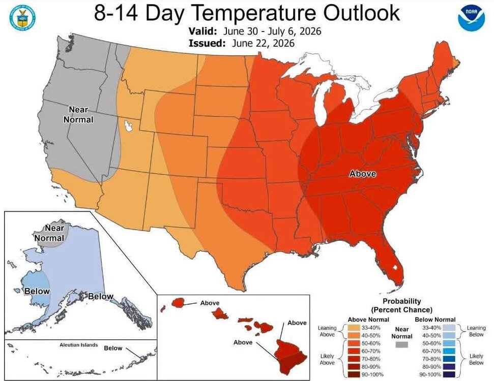
July looks to start out with a major heatwave (Post July 4th weather in the separate thread)
-
If liberty was here he'd be talking about the great heat wave of 1993
-
Hrrr shows a half inch for parts of north jersey
-
Now it has nothing
-
So Saturday looks like a few showers or a complete washout with 1 to 2" of rain
-
Heat is coming
-
yeah I think saturday is overdone and will end up cloudy and mostly dry
-
Another perfect morning
-
-
Yeah I'm thinking about a tenth to maybe a quarter inch more at most. But at least we did well yesterday
-
Should be here momentarily
-
Its just rain
-
Yeah around the elizabeth ewr area
-
Storm looks pretty nasty for central union county
-
Same..very heavy rain
-
Yes the radar has greatly improved in the past 20 minutes
-
Very dark to the west/northwest
-
Looks like we're in the screw zone
-
Hopefully the nam has a clue. Wasn't it supposed to be retired by now?


