Stormlover74
-
Posts
24,211 -
Joined
-
Last visited
Content Type
Profiles
Blogs
Forums
American Weather
Media Demo
Store
Gallery
Everything posted by Stormlover74
-
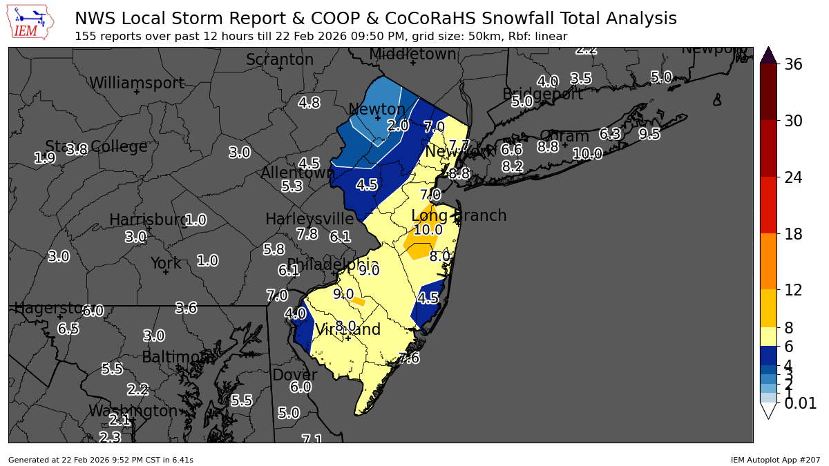
Not sure if posted..all the sites that reached blizzard criteria https://forecast.weather.gov/product.php?site=OKX&issuedby=OKX&product=LSR&format=CI&version=3&glossary=0
-
In between bands its still dumping
-
The euro sorta caught on at the end. Rgem never did. Every run was awful
-
Wow ewr up to 21
-
My app says I'm currently in a snow shower as I can barely see down the street
-
Hrrr keeps that heavy band over nj stationary or moving slightly west for the next 5 hours
-
Can barely see 100 feet
-
Not sure..I found it posted on another site
-
Ive never seen a running tally like this

-
Ewr 7" report
-
Hrrr shows weakening returns and a lull around 5/6z before the heavy stuff starts to rotate back in
-
2am
-
Late tonight
-
Not suspended?
-
Wait you have 7" already or is that including old snow?
-
Early afternoon. Light stuff may linger but probably end of accumulations by 1 or 2
-
I don't think it was a complaint just an observation.
-
Lol hes talking about the snow not being as wet as expected
-
The obs threads gone again lol Temp down to 30
-
Wild differences between the rap and the hrdps west of nyc
-
Rap has more by 4am than the entire gfs and rgem runs for western areas
-
31 with moderate snow and winds picking up
-
32 with mod snow and winds picking up. Roads covered
-
Its premium
-
Hrrr a foot plus for most through 6am