

Blizzwalker
-
Posts
94 -
Joined
-
Last visited
Content Type
Profiles
Blogs
Forums
American Weather
Media Demo
Store
Gallery
Everything posted by Blizzwalker
-
Does it torch ? Does it thermally exceed all expectations -- and dash our hopes ??
-
Interesting to me that u have little ice in Sullivan while just west of Middletown we have what looks like .25. U mentioned it may be elevation dependent. I am at 700 ft-- only expect a 1-2 degree lower temp from your elevation. Maybe some other variables also contributing to this difference ??
-
Very light steady snow just W of Middletown.
-
Snowing very light but steady just west of Middletown.
-
Cautious descriptions of a trend are always informative. Terms like "mega-torch, torch on steroids, and thermal cataclysm" not so helpful. They seem to imply a need to see extreme condtions that would disappoint others expectations...
-
Yeah it's about 2300 ft. I said Sullivan but it's actually Ulster co. Always looks more wintry than I expect.
-
2nd ice pix..
1-10-22two.thumb.jpg.653dcdb76295b19f91e5377487c1f986.jpg)
-
An ice picture I took on Jan 10. Went up on Sams Point near Ellenville in Sullivan Co. 0 wind chill. ( I'm always the first person to show disdain at windchill numbers thrown around in the media. OK, it was about 14, but 0 sounds better...)
1-10-22TWO.thumb.jpg.18c5bd89ed9c4dcbf8ecccdbbe1897ba.jpg)
-
Some mood (disorder) flakes near Middletown. Confusing diagnosis with December outlook, I guess...
-
Moon over Ashokan reservoir in Catskills last month. Something to look at while we wait for NAO, PDO, PNA, AO, EPO to favorably align...oh, I forgot the strat warming and gravity wave that might save us in February. Trying to be hopeful...
11-6-21.thumb.jpg.34f57ac5af78f3dae00e8d7996c481d8.jpg)
-
Looking on the NW thread but few comments about svr storms. Just w of Middletown have been rocked by lots of lightening and some winds past 50. Surprised I still have power. First gusts knocked my 2 mandevillas off my back deck.
-
I've wondered this too around Middletown, NY. We DID get reasonably well hit from convection line last nite with lots of lightening, but in watching radar intently over multiple summers, seems like there is some topographic feature that causes storms to "split" in Eastern PA as they are approaching western Orange county....looks like a decent line, then north and south (by 20 miles or so) get hit and we get an impoverished bit of rain and distant thunder. Seems it happens with non-noreaster snowstorms also. Maybe I'm just a frustrated wishcaster with too small a sample size.
-
Few Tstms with hail-gust 40-45KT 1P-6P especially NJ/se NYS/w LI
Blizzwalker replied to wdrag's topic in New York City Metro
Using word "tornadic" to mean "tornado like", or "pertaining to tornadoes". Perhaps I should have indicated that the protruding section of cloud in the image appeared capable of developing into a true tornado....seems like a semantic storm in a teacup... -
Few Tstms with hail-gust 40-45KT 1P-6P especially NJ/se NYS/w LI
Blizzwalker replied to wdrag's topic in New York City Metro
I defer to severe WX experts... -
Few Tstms with hail-gust 40-45KT 1P-6P especially NJ/se NYS/w LI
Blizzwalker replied to wdrag's topic in New York City Metro
Taken by my son around 2 PM today at airport where he works in Lagrangeville NY. Looks tornadic...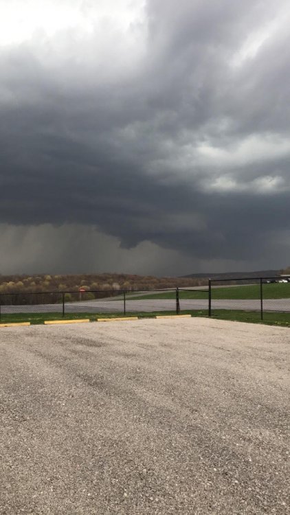
-
Are there microclimatological factors contributing to snow depth variation that go unaccounted for ? Sure. Are there differences in measuring techniques/instrumentation that lead to inaccuracy in snow depth measurement? Certainly. Do we have members whose self-esteem is so interwoven with snow depth that they would lie ? Unlikely....
-
Yes- i have also seen the larger flakes today. Was referring to all day yesterday until around midnite. All I saw was granules for many hrs-- ok, not 24, but we waited a longer time for flakes than most in the forum
-
Nice to get snow with actual Dendrites attached here in Middletown. Was getting tired of 24 hrs of micro-granules
-
OBS and nowcast Thursday morning 2/18 - 11PM Friday 2/19/21
Blizzwalker replied to wdrag's topic in New York City Metro
Just w of Middletown -- getting a light burst of .01 mm non-dendritic granules. Not what I had hoped for but trying to appreciate it.... -
Feb 18-19 long duration manageable snow and ice event
Blizzwalker replied to wdrag's topic in New York City Metro
That nws event total map is 6 hrs old- from 4 PM. Hope next such map does not lower amounts -
Feb 18-19 long duration manageable snow and ice event
Blizzwalker replied to wdrag's topic in New York City Metro
I was wondering more about the track of the storm as opposed to the intrusion of a warm layer. ( I know the more N track can lead to warming). -
Feb 18-19 long duration manageable snow and ice event
Blizzwalker replied to wdrag's topic in New York City Metro
Multiple storms have recently shown a modest NW shift late in the game. Are there reasons making such a shift less likely with this storm tomorrow? -
Feb 18-19 long duration manageable snow and ice event
Blizzwalker replied to wdrag's topic in New York City Metro
Yes, understood. But it is not just lower amounts with noaa total event map--- it is reverse gradient. Noaa had more snow NW, Nam had more snow SE -
Feb 18-19 long duration manageable snow and ice event
Blizzwalker replied to wdrag's topic in New York City Metro
Nam has 5 inches for nw Orange co but 8 for city at 57 hrs. Noaa has 7 inches on their "event total" for nw Orange co and less as u go SE toward city. Why would that be ? Because it is Nam beyond 48 hrs ?


1-10-22two.jpg.42545131eaf75193ee171488d9a9fc2d.jpg)
1-10-22TWO.jpg.7bee416deae39067fba2b110532f5891.jpg)
11-6-21.jpg.fb779f6e6f9717419c58b26855275085.jpg)
