ROOSTA
-
Posts
3,144 -
Joined
-
Last visited
Content Type
Profiles
Blogs
Forums
American Weather
Media Demo
Store
Gallery
Everything posted by ROOSTA
-
Surprise, surprise my power is out. Only one big pine fell, lucky. Only a foot of rain, highest gust 85mph.
-
Meant to post earlier https://www.facebook.com/share/p/B1WTggiDn4ppvrmC/ A variety of cams
-
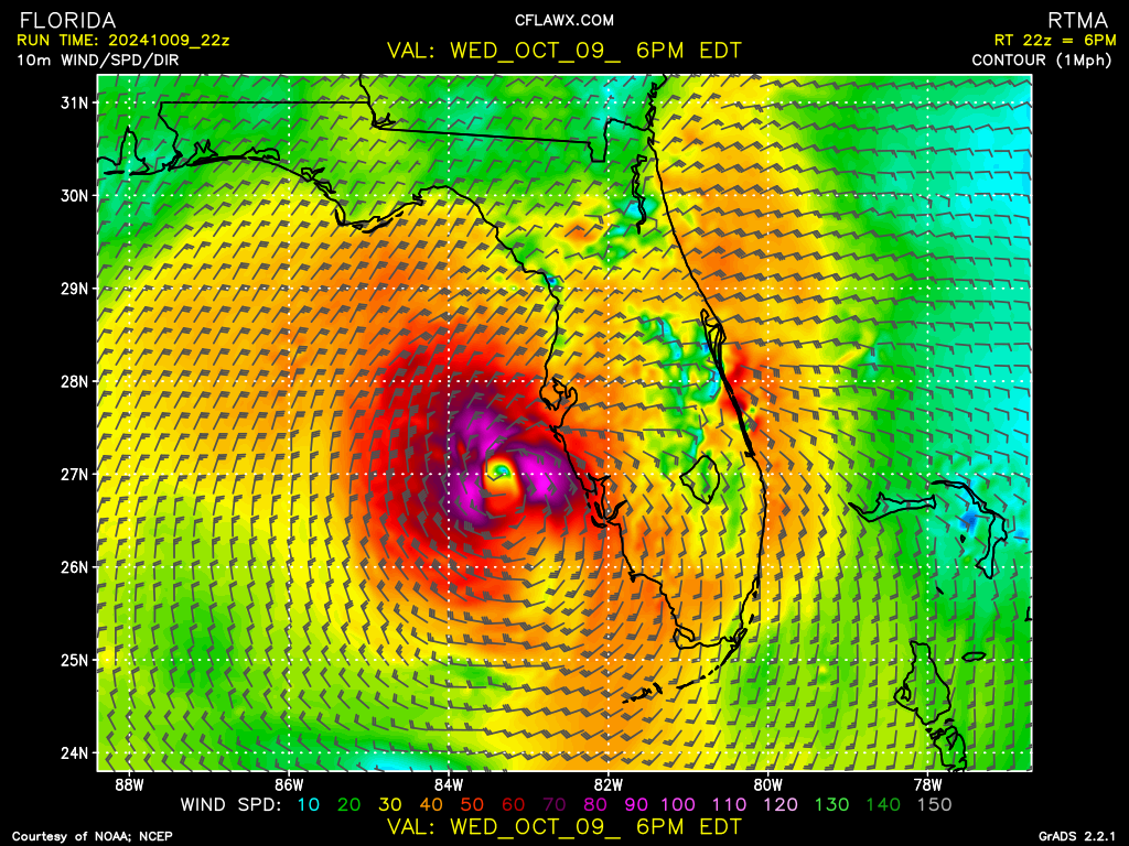
The Inner Core is intact

-
Blitzortung.org - Live Lightning Map Already starting to get some rumbling. This is not good.
-
Discrete cells with definite hooks propagating outward in the first true outer spiral band - RFQ Does anyone know how fast an EWRC has taken place? My expected gusts have dropped for N. Lake County. I just want the power to stay for one good meal Dinner tonight. LF Tampa Bay.
-
Moving slightly N of NE at least by my estimate. TB radar using GR3v2 range rings with marker. Official forecasted track N of previous advisory. GFS (hot stuff) has been steadfast on track. Social Media is bonkers everyone has an opinion, not worth posting anymore.
-
Almost in radar range. Discrete cells - waterspouts galore KBYX. Not a good sign for RFQ EF spin-ups tomorrow.
-
Yes, gaining more LAT than LON presently and not a wobble. My call straight into TB. Call it THE TB12 payback for Pats fans. LOL j/k Serious stuff right there. ****** PSU website has 1 minute refresh with better resolution for SAT
-
How low will it go before another ERC? Perfect symmetry. All systems go. LF earlier and stronger.
-
The further S this tracks the better as far as I'm concerned. Milton appears to be RI to maybe challenge the lowest pressure record once again. My adrenaline is pumping. Scary to think of the damage in Coastal communities as well as inland direct path.
-
Distinctly noticing a wobble to the right, lost the symmetry from its peak. EYE is contracting to a pinhole. Anyone have the latest vort data?
-
Written with a tinge of sarcasm. I'm well aware of the destructive nature of storms in New England.
-
Unfortunately, no. I did at my first house here a Generac. Just haven't gotten around to getting one at the new place. No portable generators in stock anywhere in the state. Nice to see the highways jammed, people heeding the warnings and threat. ERC in progress. What a Monster
-
Must be said. This doesn't even come close to tracking a Nor'easter (Blizzards) A nice gentle snowfall with 70mph. winds, accumulations 4"/hr. Sure, some power-outages and travel standstills BUT at least building stay intact. A 20' surge and 2-3X the wind-force is a completely different BEAST. I'm fully expecting the power outage here for 5+ days.
-
Just envision a 10-mile-wide tornado akin to Andrew and surge of Camille.
-
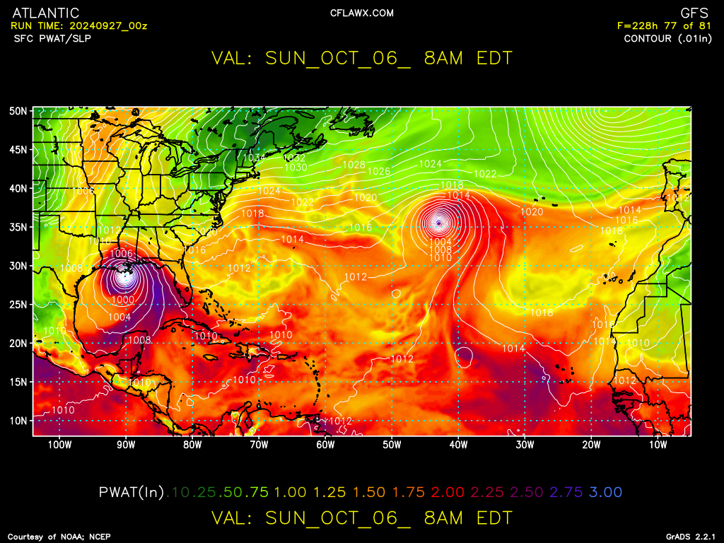
18z GFS initialized only 50mb off actual pressure. Uncharted even HFSA had the lowest at 910mb through the run. The 12z HFSB has an 880mb as the lowest pressure which will break Wilma.
-
AWESTRUCK is one word. BREATHTAKING is another. And to be in the path... Wow, I pray the people under evac get out. Record breaker for sure! How low will he go? NHC site is crashing.
-
Caught between the adrenalin rush from tracking, watching it bomb-out and the catastrophic damage this could cause. Family picked a bad week to come down to Disney. The wind-field radii is going to be expansive and strong. Cone is narrowing! How low will he go?
-
Reverse surge in TB if verified as is now, that's going to change on the 18z runs.
-
Alot at stake being a populated area to which many have never experienced. LF appears to be trending S with uncertainty catching many by surprise. Not liking the Hurr. models spitting out intensities to such a degree, hopefully shear and drier air gets rapped into which would be a double-edged sword- expanding the wind field. I'm living close enough to be very concerned. I have a huge Southern Oak overhanging the lanai in the back of the house not exposed to such strong winds in a longtime.
-
One of the experiences on "my bucket list" is to be standing in the eye of a Major Hurricane. ***NOT IN MY YARD*** Oh, baby here we go. Chances are increasing for just that with each run. I'm so far inland fear of surge or flooding should bypass (LAT 28.97, LON 81.63) None from the former and negligible on the latter. Milton for obvious reasons I will prep for.
-
Maybe a double hitter

-
That was an easy storm to track and forecast. The consistency of the GFS was dead-on from D10 to LF absolutely FANTASTIC. I only lost power from 8:00pm. to 3:30am. Started getting a bit concerned about intensity being spit out by the hurricane models being so right of the global. Could have wobbled at the 11th hour with my results being far worse. My stations data records: Lowest Pressure: 29.41InHg. - 21:03 Highest Wind Gust: SSW 63mph. - 01:26 A little Rain only - 0.36In. You can clearly see the discoloration in the Gulf from upwelling. NEXT
-
Just had a shower pass through, one of those outer-outer spiral bands. .23" in one-minute. This storm seems different than other events. It's a unique feeling with dews and temp in the upper 70's. The air you can wear. In the 12yrs being here the highest wind experienced was 93mph. in Michael. Power was out for 6 days!
-
It's not the quantity but the quality of the tropical season. Only taking one to memorialize and it ain't over. Was it dust, shear or the latitude of the waves exiting the African coast? Thinking is the present threat the whole W. Coast of Florida from Tampa Bay to the Big Bend. Ground Zero.