high risk
-
Posts
3,240 -
Joined
-
Last visited
Content Type
Profiles
Blogs
Forums
American Weather
Media Demo
Store
Gallery
Everything posted by high risk
-

2021 Mid-Atlantic Severe Weather - General Discussion
high risk replied to Kmlwx's topic in Mid Atlantic
I'm just about entirely out for tomorrow for those of us north of I-66 in VA and Rt 50 in MD. There isn't any guidance right now that brings sfc-based instability this far north. In fact, any severe threat is likely to be a good distance south of DC. Definitely expecting some elevated convection up this way, but we're going to end up on the cool side of the boundary. Not looking forward to the possibly low to mid 50s Saturday. -
2021 Mid-Atlantic Severe Weather - General Discussion
high risk replied to Kmlwx's topic in Mid Atlantic
That was the day several cells just north of I-70 interacted with the warm front there and produced several (low-end) tornadoes. -
2021 Mid-Atlantic Severe Weather - General Discussion
high risk replied to Kmlwx's topic in Mid Atlantic
Tomorrow has sneaky warm front potential for sure, as storms interacting with and just south of the front will be in an environment with very favorable hodographs. The question is where the warm front sets up. Right now, I'd definitely want to be south of DC (in line with the SLGT risk area), as I think it's going to be too stable at the surface for those of us north of town. -
2021 Mid-Atlantic Severe Weather - General Discussion
high risk replied to Kmlwx's topic in Mid Atlantic
had a bit of a downburst here in North Laurel. Had been heavy rain with very little wind, and the rain then went torrential with small hail and a huge burst of wind that took down some tree limbs and blew out a transformer in my neighbor's yard. -
2021 Mid-Atlantic Severe Weather - General Discussion
high risk replied to Kmlwx's topic in Mid Atlantic
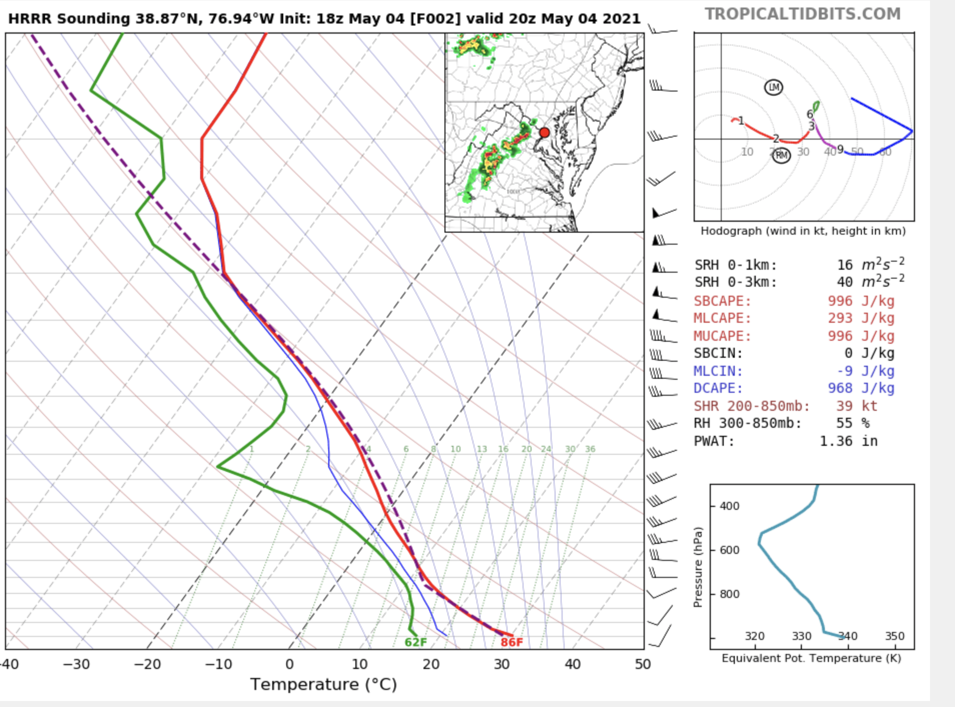
HRRR is still by far the most aggressive model in mixing out the low level moisture. I'll be closely watching the dew points early this afternoon - if they fall into the upper 50s or lower 60s, I'll temper my expectations. If they stay in the mid or upper 60s, the CAMs with stronger, more widespread storms are more likely to be right. -
2021 Mid-Atlantic Severe Weather - General Discussion
high risk replied to Kmlwx's topic in Mid Atlantic
Yeah, they extended the 2% down here because a couple of HREF members have some very, very modest UH tracks. The afternoon storms probably have close to zero tornado potential, because as you noted, the shear is so weak. A window for a brief tornado might exist in the early evening if there is a round 2: the LLJ will strengthen a bit, and since it will have a westerly component, if the surface winds can back a bit near a leftover outflow boundary, a cell could briefly acquire rotation. If SPC had a 1% TOR contour, that would work just as well. -
definitely encouraged about getting meaningful rain at the end of the week, although I'd prefer to not wash out the entire weekend. The Euro is really slow to move everything out and would make for a pretty wet and ugly Sunday. The GFS has been more progressive, but the GEFS is clearly trending towards a wetter Sunday. Slow movement of the trough is key to a big rainfall event, as the totals for Friday night across most guidance aren't huge due to the better overrunning likely setting up to our north.
-
2021 Mid-Atlantic Severe Weather - General Discussion
high risk replied to Kmlwx's topic in Mid Atlantic
Nice for sure to be "back in the game". Tomorrow certainly has some modest potential. Deep layer shear is going to be close to the lower thresholds for severe - the question seems to be how much will the moisture mix out. The NAM nest has been consistently keeping much higher low-level dew points, while the HRRR has been most aggressive with the mixing and lowers the dew points the most. The NAM nest therefore has the most widespread convection, while the HRRR has the least. The other CAMs are for the most part in the middle in terms of low-level moisture and in coverage of storms, so I think that a MRGL is ok for now, with potential to go to SLGT if the mixing of moisture ends up to be less of a factor. -
heavy gusty shower with small hail
-
2021 Mid-Atlantic Severe Weather - General Discussion
high risk replied to Kmlwx's topic in Mid Atlantic
Yeah, Friday is kinda interesting. There isn't much CAPE at all in the forecast soundings, but a 500 mb temperature of -25C is certainly worthy of attention....... -
2021 Mid-Atlantic Severe Weather - General Discussion
high risk replied to Kmlwx's topic in Mid Atlantic
Definitely a better event than I was thinking earlier, as the deep layer shear is better than progged earlier. That said, while I can see the stronger cells acquiring some broad rotation, you can't get strong low-level rotation with this wind profile: unless the model is way off with the weak low-level speeds that it's showing. It also doesn't look very good with the instability, but if lapse rates are better, there is plenty of dry air below cloud base to generate some intense downdrafts.
-
2021 Mid-Atlantic Severe Weather - General Discussion
high risk replied to Kmlwx's topic in Mid Atlantic
Yeah, trends are definitely good, and the full 12z suite of CAMs is quite encouraging. That said, despite some decent mid-level flow and inverted-V profiles, low level winds in the forecast soundings are quite weak. So, I'm enthusiastic about stronger storms in the area later today, but I think that not going any higher than MRGL right now makes sense. -
2021 Mid-Atlantic Severe Weather - General Discussion
high risk replied to Kmlwx's topic in Mid Atlantic
(5:30pm) That's a really interesting storm just northwest of Winchester.... -
2021 Mid-Atlantic Severe Weather - General Discussion
high risk replied to Kmlwx's topic in Mid Atlantic
The 12z parent NAM giveth, the 00z taketh away.... Not very excited about Tuesday now, based on what I've seen in the evening runs. I'm on board with the MRGL for Monday - looks like some stronger convection later in the day (especially north of DC), in an environment that isn't great but isn't awful either. -
One thing to watch is a secondary cold front that will move through in the very late afternoon. NAM Nest is most aggressive is actually generating a line of very gusty showers on the front. The frontal passage itself will likely enhance the winds even further.
-
2021 Mid-Atlantic Severe Weather - General Discussion
high risk replied to Kmlwx's topic in Mid Atlantic
Yeah, Monday and either Tuesday or Wednesday (per the Euro) seem to have at least some potential next week. -
2021 Mid-Atlantic Severe Weather - General Discussion
high risk replied to Kmlwx's topic in Mid Atlantic
We have a MRGL today for areas generally north of the Capital Beltway in MD and Rt 7 in VA. CAMs suggest that the small window of opportunity for a few small clusters of northeast-moving cells with modest wind potential exists around dinner time, and the best chances *may* be in north-central and/or northern MD. A decent line on the cold front will approach the far northwest sections by early evening, but due to winds veering in the DC-Baltimore area behind the lead surface trough, limited convergence will likely cause the line to weaken or entirely fall apart. I'll be happy with some rain and a few rumbles of thunder (neither of which is a certainty). -
2021 Mid-Atlantic Severe Weather - General Discussion
high risk replied to Kmlwx's topic in Mid Atlantic
As it looks now, the early Friday period does have some very limited SVR potential, with a strong front pushing through amidst some fairly impressive wind fields. Ultimately, though, the poor timing of the front and limited moisture will likely eliminate any threat without some significant modification to the evolution. The GFS idea of a phased trough, instead of the northern stream system shown by most other guidance, would help. -
31 this morning in southern Howard County
-
2021 Mid-Atlantic Severe Weather - General Discussion
high risk replied to Kmlwx's topic in Mid Atlantic
radar looks good along I-95 in VA for sure, although I think that this activity (except perhaps for the cells moving into Calvert County) is just behind the front which has now cleared IAD and DCA. -
2021 Mid-Atlantic Severe Weather - General Discussion
high risk replied to Kmlwx's topic in Mid Atlantic
Several of the CAMs this morning do break out some showers on the east side of town in the 1-2pm hour, although it appears that they are actually just behind the front. This lessens a threat of big wind, although it may still be sufficiently mixed to bring some decent gusts to the surface. The question is still whether something can form just ahead of the front around noon. Only the HiResW ARW2 suggests this scenario. -
2021 Mid-Atlantic Severe Weather - General Discussion
high risk replied to Kmlwx's topic in Mid Atlantic
I mostly agree with this. April tends to struggle to generate much SVR here (even the best setups often leave the Mid-Atlantic in a cold air damming scenario), but there are notable exceptions. And it certainly seems to be our best month for hail. It feels to me (and I'm too lazy to go check) that our best TOR threat here runs something like May 15-June 15 (maybe June 15 is a bit late, but I think you need to include at least the first 10 days of June), and after that, we get more of the linear or MCS severe threat. But I may be speaking out of my @ss on this. -
2021 Mid-Atlantic Severe Weather - General Discussion
high risk replied to Kmlwx's topic in Mid Atlantic
The Euro is clearly in the "faster front camp". Seems like the GFS/ECMWF/HRRR camp gets things going either just east or a good distance east of our area. The NAM and several HiResWindows (some of which are initialized from the NAM...) have a slightly slower front which gives most of us east of the Potomac a good event. A 1 or 2 hour change in the timing of the front is going to make a huge deal. -
2021 Mid-Atlantic Severe Weather - General Discussion
high risk replied to Kmlwx's topic in Mid Atlantic
I agree fully. Could be like that Sunday event in March when we had no lightning but had a bunch of wind reports. I still think, though, that the timing is the biggest factor that is *potentially* working against us. The HRRR is still faster with the front, and the better activity gets going just east of the area. The latest NAM nest is still good verbatim, but it has notably sped up the front, relative to earlier runs. A 1pm frontal passage vs an 11am passage could make all of the difference here. -
2021 Mid-Atlantic Severe Weather - General Discussion
high risk replied to Kmlwx's topic in Mid Atlantic
One clear fail scenario being depicted is the front going through too early in the day, as shown in the 00z HRRR and 12/18z GFS. If I had to wager, I'd say that the GFS is too fast, and the HRRR gets some indirect synoptic influence from the GFS, so that *might* explain why it looks similar. But I'm not confident at all in saying that. Ultimately, the later the front arrives, the better the chances of severe.