high risk
-
Posts
2,915 -
Joined
-
Last visited
Content Type
Profiles
Blogs
Forums
American Weather
Media Demo
Store
Gallery
Everything posted by high risk
-
I should have said "late spring", as April or May seems far more likely. WAY too much SREF talk in here this evening........
-
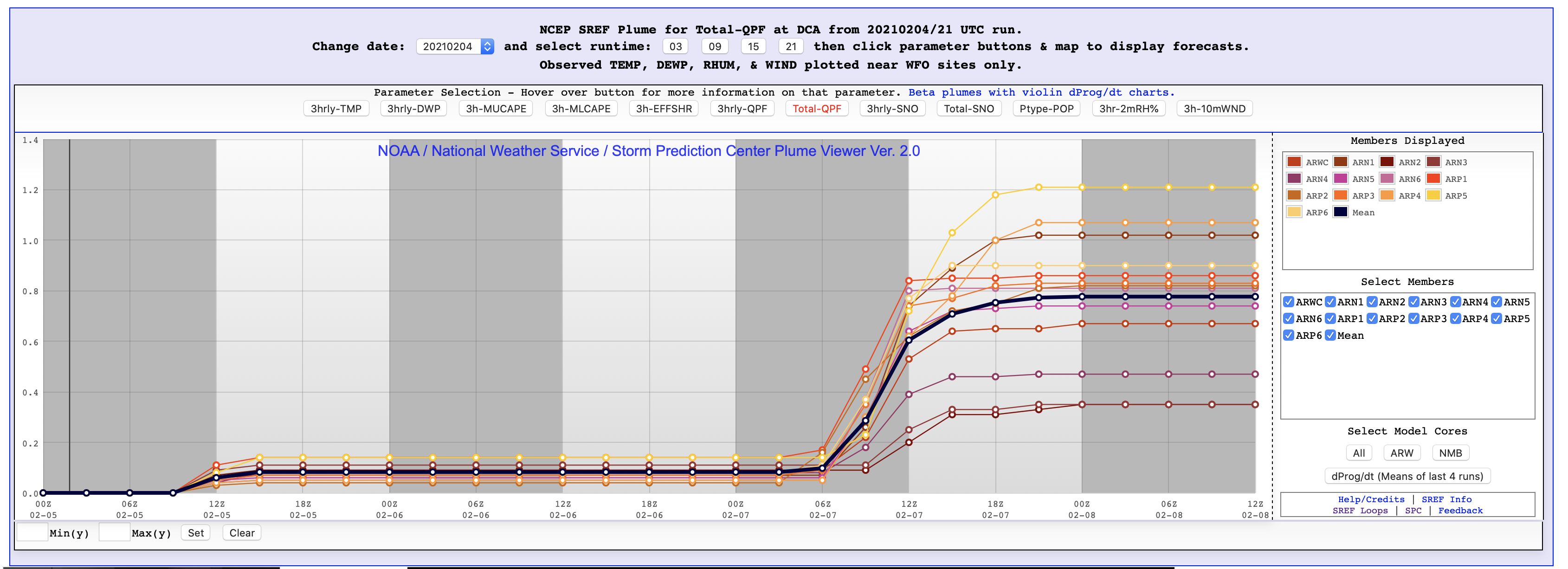
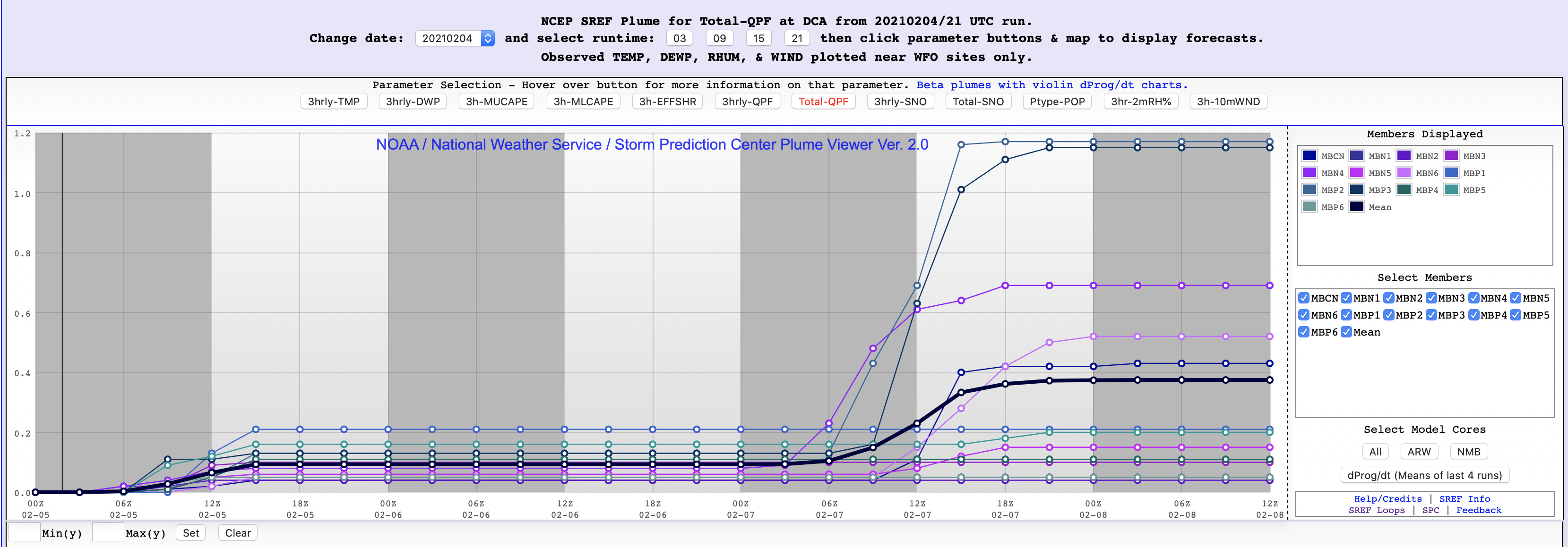
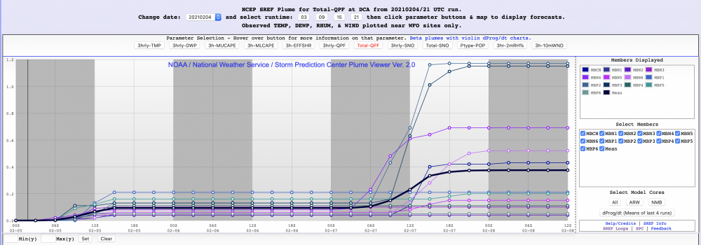
here's exhibit A for what I was mentioning about the two camps of SREF members. For the upcoming event, the ARW member are amplified, and the QPF is rocking' For the NMMB, there are a couple of exceptions, but they're mostly light, suppressed events:

-
The SREF was a good idea, as it mixed and matched two different model cores, initial conditions from three different systems, and different physics. It's really, really tough to get meaningful spread in the short range, so the approach was smart, but the problem is that things were never successfully tuned. You have 26 members, but you often get two camps, with clusters for each of the two cores. The ARW members tend to be very amplified, and the NMMB members tend to be flat. The middle ends up being ok-ish, but you could get the same answer with just one member from each of the two cores. But I agree that it shows the general range of possibilities. The SREF will be turned off once it is established that the GEFS can cover the short range, as AWC and WPC still use the SREF. HREF simply blends the NAM nest and the three Hi-Res Windows. Version 3 (coming this spring) includes the HRRR too, and the Hi-Res Window NMMB member gets replaced with an FV3 member. It's only as good as the models that comprise it, and there are shortcomings as Millville noted, but it scores quite well. It will serve as the baseline for the new Rapid Refresh Forecast System (hi-res, 10 member, hourly FV3 ensemble) which is probably ~3 years away.
-
Yeah, this morning's AFD from LWX is NOT aging well.....
-

Feb Long Range Discussion (Day 3 and beyond) - MERGED
high risk replied to WinterWxLuvr's topic in Mid Atlantic
Important note: The Euro run total maps include some snow tomorrow morning, including some for the northern part of this sub-forum. -
Feb Long Range Discussion (Day 3 and beyond) - MERGED
high risk replied to WinterWxLuvr's topic in Mid Atlantic
Absolutely. The last 4 cycles have all ticked to the northwest with an axis of moderate snowfall. -
Feb Long Range Discussion (Day 3 and beyond) - MERGED
high risk replied to WinterWxLuvr's topic in Mid Atlantic
The ICON isn't included. FNO is the Navy (Fleet Numerical) model. CFSR is a version of the Climate Forecast System that is serves a bit of a baseline. -
Feb Long Range Discussion (Day 3 and beyond) - MERGED
high risk replied to WinterWxLuvr's topic in Mid Atlantic
No offense, but that's a poor take - you can't assess it by a single 30 day period. It has been run since last summer in real-time, and retrospective runs were made to cover the previous year. The scores for the para were overall better, and it's also better in several aspects of performance besides the 500 pattern (reduced cold bias, improved precip scores, better hurricane intensity.....) -
Feb Long Range Discussion (Day 3 and beyond) - MERGED
high risk replied to WinterWxLuvr's topic in Mid Atlantic
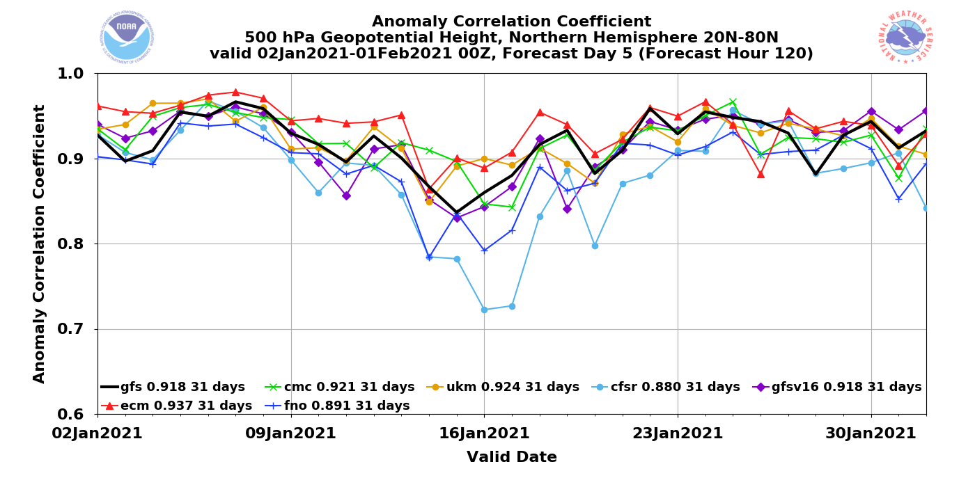
Fair, although if you look at the composite numbers at the bottom of that image, it's a tie over the past 30 days. And GFSv16 scored better than GFSv15 throughout most of the retrospective runs. Tons of great info here: https://www.emc.ncep.noaa.gov/users/meg/gfsv16/ -
Feb Long Range Discussion (Day 3 and beyond) - MERGED
high risk replied to WinterWxLuvr's topic in Mid Atlantic
FWIW, the GFS Para (GFSv16) has been scoring well in the past week. Here the day 5 scores for 500 mb heights over the Northern Hemisphere (GFSv16 is purple): That's just for the 500 flow over the entire Northern Hemisphere, and it doesn't mean that it nailed specific details for the storm, and it also doesn't mean that it will be awesome handling next week. Definitely encouraging, though! EDIT: to be fair, ALL of the models have been scoring well, so the pattern has been generally predictable. Perhaps that will be changing....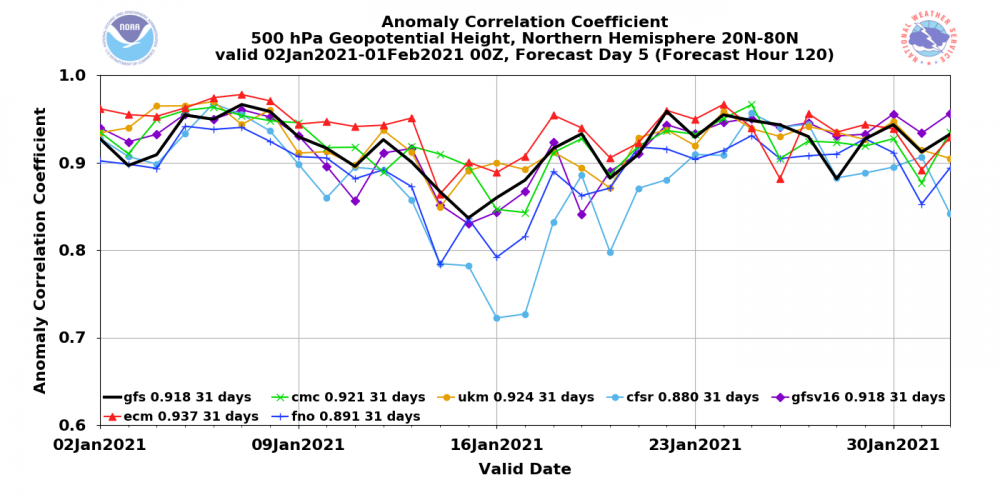
-
Feb Long Range Discussion (Day 3 and beyond) - MERGED
high risk replied to WinterWxLuvr's topic in Mid Atlantic
several of us on the previous two pages in this thread. -
Feb Long Range Discussion (Day 3 and beyond) - MERGED
high risk replied to WinterWxLuvr's topic in Mid Atlantic
Yikes. Thanks for pointing that out. Seeing the 12z GEFS out to day 5, at the risk of analyzing too early, it certainly appears to be headed at least somewhat in the same direction. -
Feb Long Range Discussion (Day 3 and beyond) - MERGED
high risk replied to WinterWxLuvr's topic in Mid Atlantic
That is a pretty crazy change in the 12z GFS, as so much troughing gets into the northern plains that it actually pumps up an east coast ridge for part of next week. There wasn't much support for that in earlier GEFS runs - curious to see if the 12z GEFS supports it. -
Jan 31st - 33rd Storm Obs and Disco like it's 1979
high risk replied to Bob Chill's topic in Mid Atlantic
It could certainly be overdone, but it's not on an island with the general concept. -
Jan 31st - 33rd Storm Obs and Disco like it's 1979
high risk replied to Bob Chill's topic in Mid Atlantic
18z NAM nest simulated radar for the DC-Baltimore corridor looks glorious, but the precip amounts....meh. That said, it certainly seems that some of the localized bands will over perform and perhaps in a big way (and this won't be well captured by guidance), so at this point, I'm happy to see a lot of simulated reflectivity over this area. -
Feb Long Range Discussion (Day 3 and beyond) - MERGED
high risk replied to WinterWxLuvr's topic in Mid Atlantic
This caught my eye too. This would be a line of heavy snow squalls that caused a disaster on the roads as temps plummeted behind it. Something like this happened here a few years ago on Valentine's Day 2015.
-
Jan 31st - 33rd Storm Obs and Disco like it's 1979
high risk replied to Bob Chill's topic in Mid Atlantic
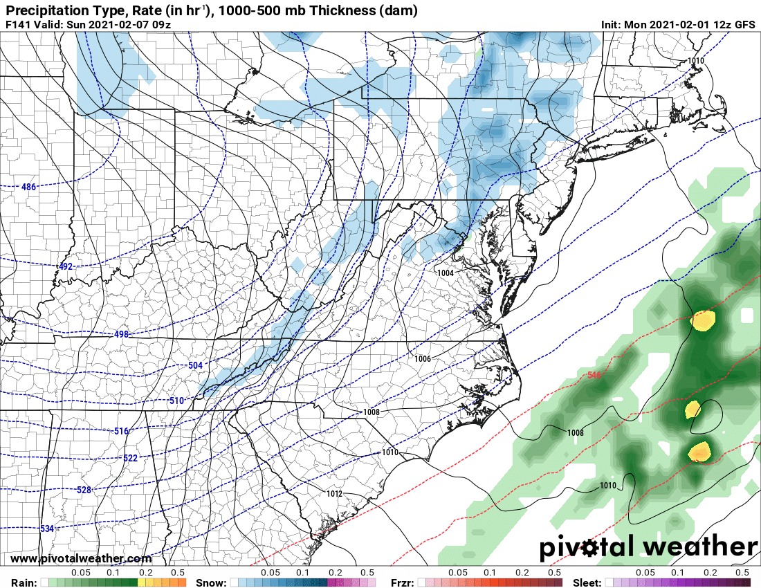
This thread has gone to hell, but the GFS para puts the brakes on the Baltimore snow party. It still wants to bring some accumulating snow to most of central MD and hits the MD/PA border nicely, but it's not doing what the ops GFS is. Looking closely, the GFS precip field is wacky with a big max on the Jersey Shore and reduced totals for the NYC metro area- GFS para looks more reasonable and consistent. -
Jan 31st - 33rd Storm Obs and Disco like it's 1979
high risk replied to Bob Chill's topic in Mid Atlantic
00z GFS is trying to sucker me back in..... -
Jan 31st - 33rd Storm Obs and Disco like it's 1979
high risk replied to Bob Chill's topic in Mid Atlantic
.... although it has a nice band going through Baltimore early Tuesday -
Jan 31st - 33rd Storm Obs and Disco like it's 1979
high risk replied to Bob Chill's topic in Mid Atlantic
It's heavier during the 00-03z or so window this evening - could be a sneaky period of moderate snow (or sleet, per the NAM nest) here before a change to light sleet or rain. -
Jan 31st - 33rd Storm Obs and Disco like it's 1979
high risk replied to Bob Chill's topic in Mid Atlantic
I'm looking at the 24h QPF totals between 12z Monday and 12z Tuesday. GFS para looks considerably drier to me. -
Jan 31st - 33rd Storm Obs and Disco like it's 1979
high risk replied to Bob Chill's topic in Mid Atlantic
Yeah, I didn't explain myself well, but I was referring to tomorrow - big differences in rates for Howard County. -
Jan 31st - 33rd Storm Obs and Disco like it's 1979
high risk replied to Bob Chill's topic in Mid Atlantic
I was very pleased with the GFS too, but the GFS para has the same general shape of the QPF field but cuts down the amounts between DC and the MD/PA by at least 1/2. -
Jan 31st - 33rd Storm Obs and Disco like it's 1979
high risk replied to Bob Chill's topic in Mid Atlantic
Might be talking about the GFS parallel which is definitely not feeling the love for the District. -
Jan 31st - 33rd Storm Obs and Disco like it's 1979
high risk replied to Bob Chill's topic in Mid Atlantic
I liked the 850 wind axis a good deal more in the nest, and there is more precip later Monday in our area than in the parent, but there is certainly no argument that even this run didn't get it done for our area.