das
-
Posts
2,298 -
Joined
-
Last visited
Content Type
Profiles
Blogs
Forums
American Weather
Media Demo
Store
Gallery
Everything posted by das
-
3.8”. They’ll go over 4” as this moves through.
-
I’ll have my daughter measure in a minute. Steeling myself for some serious “aw, c’mon dad, really?” when I ask.
-
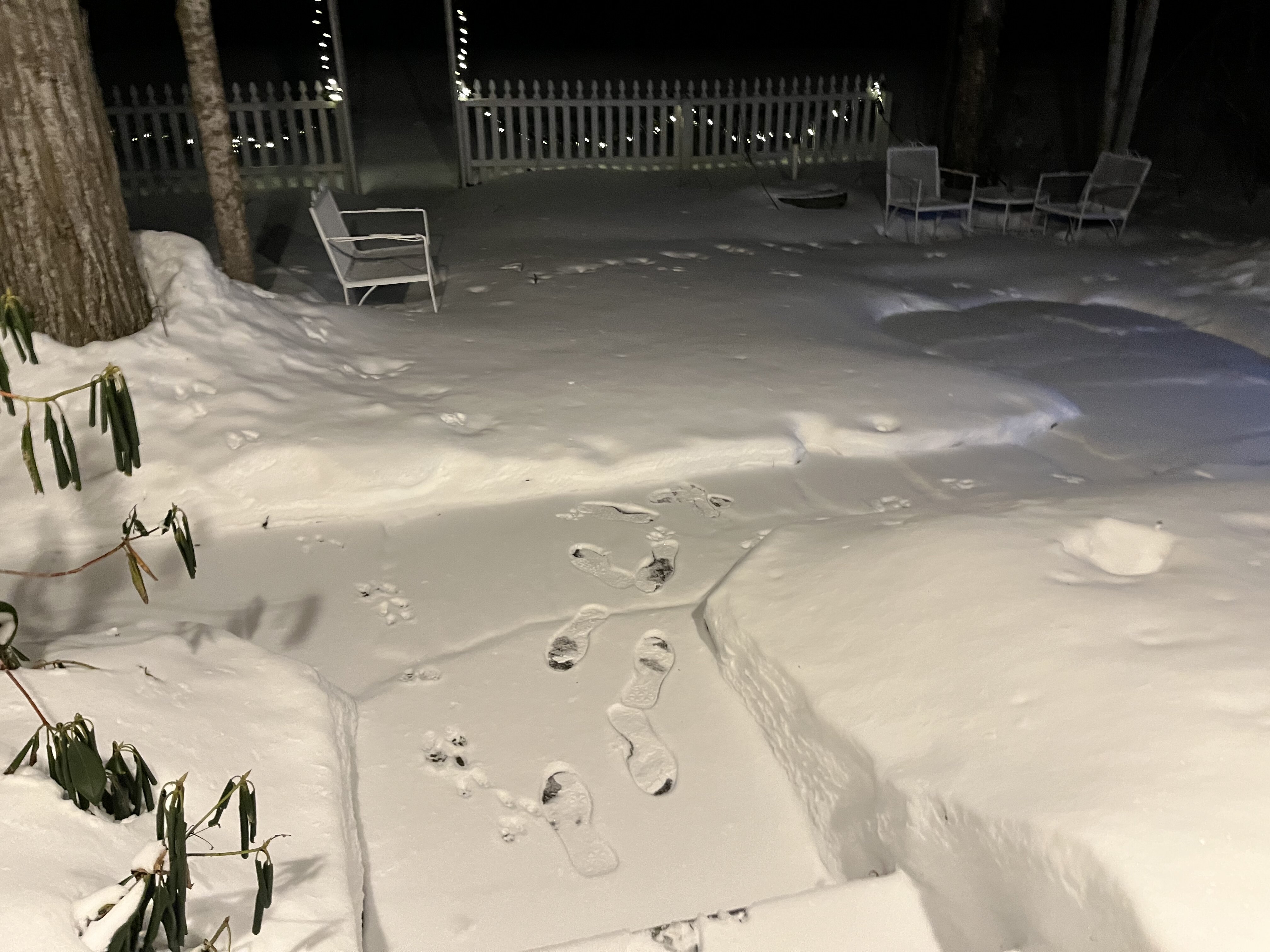
@CoastalWxYep, visibility down to 3/8 mile. This is Clarksburg, in upper Montgomery County in MD right now. IMG_0736.MOV
-
Central MD often does well in this setup. I’ll get some webcam shots from my place in MD as it rolls through in the next hour.
-
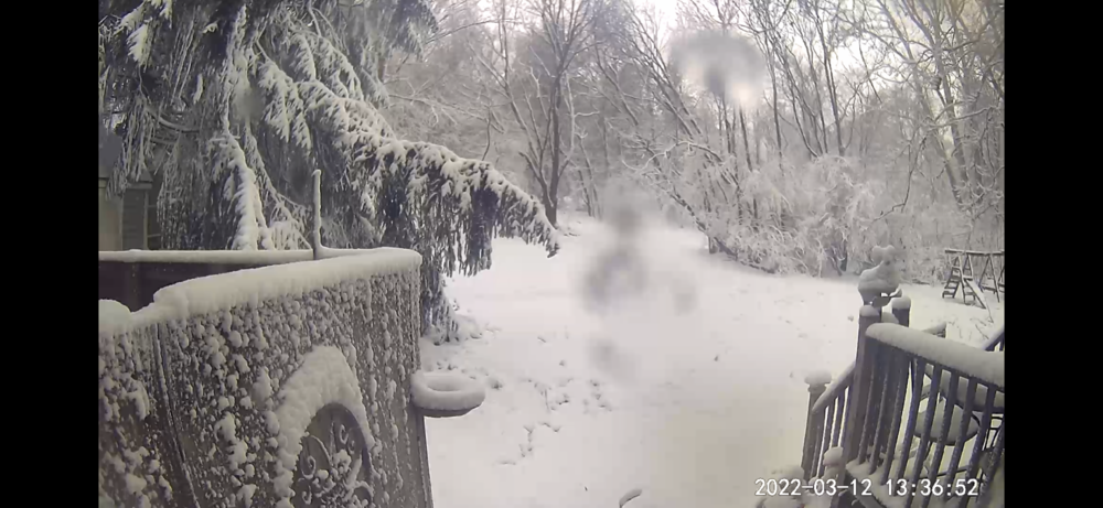
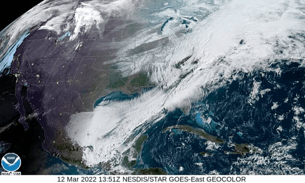
Accumulating snow in Northern Louisiana, all of Arkansas and Northern Alabama and Mississippi in mid March. Pretty cool. Just passed 4” here in Charlotte, VT.
-
March 2022 Obs/Disc: In Like a Lamb, Out Like a Butterfly
das replied to 40/70 Benchmark's topic in New England
Pretty consistent across all guidance for here. Even at 300'. -
March 2022 Obs/Disc: In Like a Lamb, Out Like a Butterfly
das replied to 40/70 Benchmark's topic in New England
54°F!!!!!
-
Winter storm for the 25th of February is imminent.
das replied to Typhoon Tip's topic in New England
Yep, here too. I saw something last week I'd never seen before. After our 1.7" of (cold) sleet, when the post-storm NW winds kicked up, it was blowing and drifting the sleet around. And, the same happened two days later when the winds channeled from the south. It's interesting around here to see storm after storm and many of the fields are largely bare for large parts of the winter due to the strong, channeled south and north winds. -
Winter storm for the 25th of February is imminent.
das replied to Typhoon Tip's topic in New England
This is what it’s like here in the valley on the other side of the Greens right now. It’s so hard it doesn’t even crunch when you walk across the top of it.
-
Winter storm for the 25th of February is imminent.
das replied to Typhoon Tip's topic in New England
I am assuming you are kidding. There is zero chance Randolph gets only 3" of snow out of this. 8-12" is nearly a lock at this point. Edited to add: on top of a glacial sheet of ice that will be really fun for sledding. -
0.7” of warm advection snow here in the Champlain Valley ahead of the squall. We’re in the calm between right now.
-
Here’s the storm report from Charlotte last night: 1.7” IP, 0.1” ZR and 0.2” SN. Water content for the lot is 1.3”. Suuuuuuper dense. Snowpack was down to 3” at the flip and probably has a couple of inches of water content since it melted down fro 7” and captured the initial rain. It’s like a glacier out there now.
-
It was pretty impressive when it went thru just past midnight last night. 5° drop in 3 minutes and 15° in 10 minutes. No real gusts as the wind shift happened. It just sorta oozed through.
-
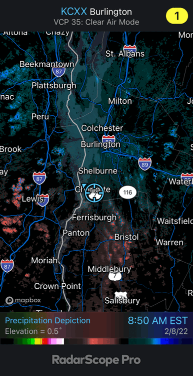
Good cold air example of Spectrum Width use tonight. You can see the cool air surging in in the lowest levels on a long loop of BTV radar. It’s usually used for TBSS and turbulent flows but tonight’s loop is a good example of a leading edge use, albeit not for a convective complex. Radar tech / remote sensing is absolutely amazing these days. IMG_0069.MOV
-
I'm down to 4" off of 7.3" to start. High today is 48ºF so far with rain on the doorstep. Normally, the rain would drag cold air down so that's where we'd top out today but the inversion overhead is sick. BTV afternoon sounding showed 19ºF at 1,800ft. and 36ºF at 3,800ft. So, 48º-->19º-->36º in the bottom 3,500ft. Will be interesting to see what the result is as the rain starts. Cold at all levels will get here just as the deep moisture is shutting off. We might eek out an inch of snow/sleet on top of the ice from overnight tonight. Here I am as the rain starts just now:
-
@jbenedetWhat model(ed)snow depth is that? It’s quite wrong here, 18 miles south of Burlington. It piqued my curiosity for MBY. 7.1” OTG with the 0.6” of fluff from the LES this morning.
-
I strolled into the gym this morning in my shorts instead of the usual sub-zero mad dash, trying to avoid stinging skin. It felt odd.
-
Snow showers took one look at New York and said, “no way, I’m not going there”. Eh, nevermind. I can't get the longer loop from 5:30am to save as a .gif in RadarScope. It showed the showers advancing from the ESE and then reversing course right at the border.
-
Light snow showers pushing thru from the ESE. 27°F. Coating so far.
-
Final total in Charlotte was 17.8” after the LES enhancement and late night PVA rolled thru with just some flurries flying around as some valley convergence pushes east and ends. Started the event with 3.5” on the ground. Snow depth sits at 15.1” right now.
-
It’s funny. I got so used to being in one of the most productive microclimates there on Parr’s Ridge in Clarksburg when you and I were in the mid Atlantic forum that it’s been odd being in one of the least here in the Champlain Valley. This has been a rare coup.
-
I’ve been under this lake-enhanced band for 2.5 hours and have 3” of fluff on top to show for it. Storm total is up to 17.4”.

-
It's picking up nicely with radar blossoming well to the WSW. I just finished shoveling and it looked like 1/2 - 3/4" per hour rates. I'm at 13.4" as of 2:30pm.
-
11.3” here in Charlotte at 8am. I’ll get a water content measurement when I can find my gage under the snow. It’s pretty dense.
-
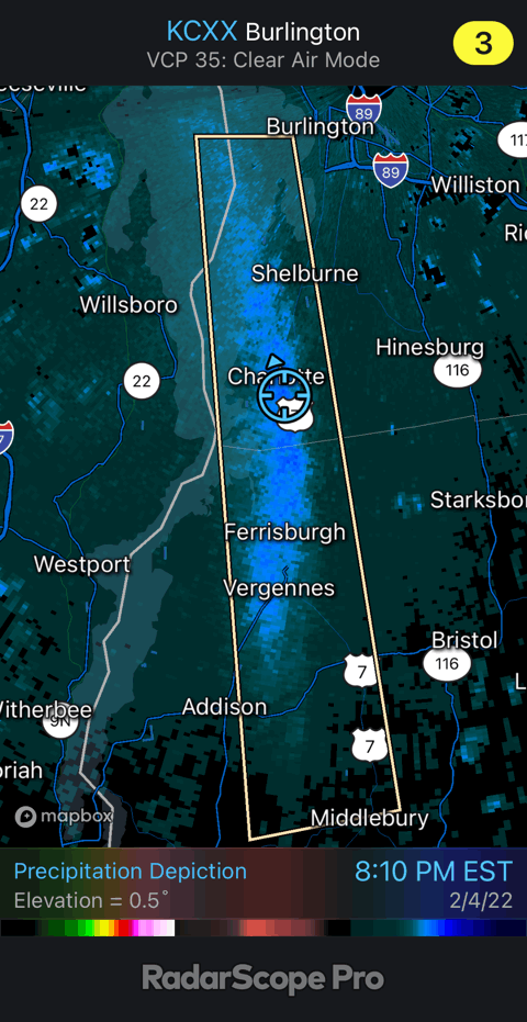
Latest Meso from SPC: Mesoscale Discussion 0128 NWS Storm Prediction Center Norman OK 0414 AM CST Fri Feb 04 2022 Areas affected...Upstate New York...central and northern Vermont...central and northern New Hampshire...and much of Maine Concerning...Heavy snow Valid 041014Z - 041615Z SUMMARY...Moderate to locally heavy snowfall -- at rates near or slightly in excess of an inch per hour in heavier bands -- is expected through this morning. DISCUSSION...Latest radar loop shows a zone of moderate to locally heavy snowfall ongoing in a band from portions of eastern/Upstate New York northeastward into Maine. The precipitation is ongoing in a zone of warm advection north and northeast of a surface low now indicated over the Blue Ridge Mountains vicinity of western Virginia, which is moving northeastward with time along quasi-stationary surface front extending from the low northeastward to southern New England. With the low not expected to deepen this morning, given very slow eastward translation of the upper system and only very weak height falls at best, the degree of low-level warm advection should remain steady. This suggests little substantial movement to the freezing/frozen precipitation transition zone with time, but instead only minor oscillations. As such, precipitation should remain in the form of snow across the discussion area. Given the cold temperatures, especially with northward extent across the region, a relatively high snow ratio (in excess of 10-1) should support rates locally in excess of an inch per hour in heavier bands. ..Goss.. 02/04/2022 ...Please see www.spc.noaa.gov for graphic product... ATTN...WFO...CAR...GYX...BTV...ALY...BGM...