jbenedet
-
Posts
7,682 -
Joined
-
Last visited
Content Type
Profiles
Blogs
Forums
American Weather
Media Demo
Store
Gallery
Everything posted by jbenedet
-
I believe MJO is still showing up according to its phases but it’s with a background that is ++AN. It’s therefore muting the cold aspect, and making it harder to notice relative to climo. But it’s there. We saw signs of this for 1 week in mid December (phase 1/8), ~5 days in Jan (phase 8), which was topped off by the weird (978mb coastal) that backed into Maine. And now with the MJO in phase 4 we’re seeing it again, with 4 days BN, topped off by PV arctic blast. But this goes right back to ++AN. MJO is loud noise; not a signal of pattern change.
-
On a Saturday; and no snow on either side of it. Screw that. Very cold and dry the worst.
-
PSM 45/41 Short term meso guidance has been trash for surface temps in similar situations all season. Just blind to it; not even correcting inside 12 hrs. So far the euro on top, but it’s also busting low.
-
We will be fighting it all day and lose by afternoon, but not before damage done and surface inversion popped.
-
Yea meso guidance over-correcting for climo again. This synoptic setup usually cooks us in the warmer months, but in winter we very often get socked in on low level northeast flow out ahead. Not the case today. Some pockets radiated last night, but there’s not even a hint of a low level cold tuck drain. Very warm day on tap in SNE and sea coast NH. Widespread 50ish again. 44/42 in Newport RI already.
-
Temps will bust way low today throughout SNE if the sun holds. 850s are warm; much warmer than yesterday. All short term guidance I looked at yesterday showed overcast. Well the sun is out; even here in Dover. Mostly cloudy, but far from socked in. Another pack-eating day with dews rising to 40.
-
March is like the longest weather month, it seems. We get like 6 months worth of March weather a year. Not just the cold months, but March weather days in April, May, and early June as well. New England
-
Lol. You guys are dense. “Birds fly south, blah blah blah.” No. But the point is really just as simple. You find animals, insects, whatever…wherever their food is readily available. Hypothesis: if the ground is snow covered and rivers, lakes, ponds frozen over, I should see no geese, bc their primary sources of food would be unavailable. If they stick around, they die. I’m in an area that Jan 29th is usually pretty shitty for geese. But they’re around, —lots of em—bc well, it’s been a lot warmer and less snowy than average. They can easily get to their food. That’s it. Boom. Mind blowing… I’m not saying the geese leave the region every winter. Hell they can probably do just fine out on the cape, or southern RI/CT, every winter, most of the season.
-
Was surprised to see Newington NH, in around the Little Bay bridge, with more bare ground than snow cover already; and the geese out in force reclaiming lost ground.
-
It’s looking like 5-10 BN instead of 20-30. Points south closer to 5, points north closer to 10 BN. And two days tops, before AN rules again.
-
There is in the northern mid Atlantic. At least sufficient for snow. It’s a small window and moderate event (at best) before we go back to ++AN the week after. This is a case where the highest amounts will be right along (just north) of the R/S line.
-
You’re in NYC. I think you misunderstood the takeaway. If things trend flatter in the eastern CONUS, the SE ridge would be helping you with the day 6 threat in terms of snow chances. But cap expectations under SECS. It’s not a suppressed look, more flat and progressive. My early take is this looks like a ribbon of snow broad, 4-8” 6-10” narrow; Indiana-Ohio to Northern Mid Atlantic. Open wave, traversing a North/south oriented frontal boundary
-
I mean, next week is looking more flat and progressive than suppressed due to confluence. If the shortwave in the southwest stays south it’s more because the southern stream is unlikely to hook up with the northern stream; and gain little latitude. This disturbance cuts off at H5 over California by the way. Not exactly a good start to pumping heights. The H5 look is messy; disjointed. Unsynchronized.
-
Looks like clipper potential. Doesn’t look exciting to me at all. I don’t think you’re too far north; you’re actually in a good spot to add a little to the pack looking out over next 7 days.
-
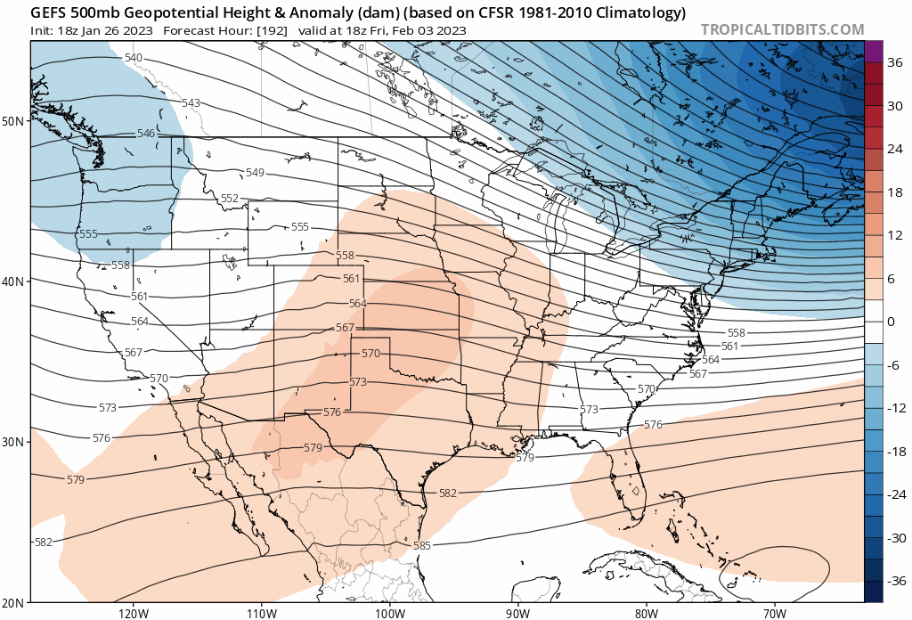
We’re losing the cold shot in early February as the SE ridge is doing what it’s been doing all season. Looks to be evolving into a more zonal look. Good news is suppression is off the table. Arctic cold with no snow is the worst.

-
Renting is under-rated around here, if you're smart. Property taxes + maintenance costs can easily surpass rent, with the right setup. That's not a loss in equity. And invest your money elsewhere. Also there's a lot of dumb landlords with much more money than sense. Get into it without knowing basic finance.
-
41/39 We melt
-
I'm expecting to lose the entire pack over the next week, save the piles.
-
Let the thaw commence
-
I get it. But we’re also heading right back into a pattern that looks especially torchy. So bias it tilted heavily AN and temps busting low for next 10 days.
-
meh. I didn’t do anything for my driveway. It’s a mess right now, but still have 40’s and sun the rest of today. The damage to the packs happens from here to sunset. And with what’s left, highs tomorrow will be mid 30’s and presuming your driveway is not in full shade, the sun will do a lot of work with that.
-
Show me the roads!
-
It seems like splitting hairs, but it's far from it. I'm a split between DAW and PSM, all year round. Take the obs in each and average them. That's Dovah.
-
DAW is north of CON. So as I said they could see 3" They are 10 miles northwest of me, and CAD on Maine Moose farts. Further from coastal plain. Dover 1" is still my guess.
-
But Wind: SE 9 I would never get out early for something like this. Not even close. There's better than even odds the roads are just wet in SW CT. The high sensitivity to this stuff assumes every parent has a full time remote job. Must be really tough for the families who don't.