

Chris78
-
Posts
4,670 -
Joined
-
Last visited
Content Type
Profiles
Blogs
Forums
American Weather
Media Demo
Store
Gallery
Posts posted by Chris78
-
-
3 minutes ago, yoda said:
We did... we already celebrated
See you Sunday with Holtby in goal

Nah. It will be Samsonov
-
 1
1
-
-
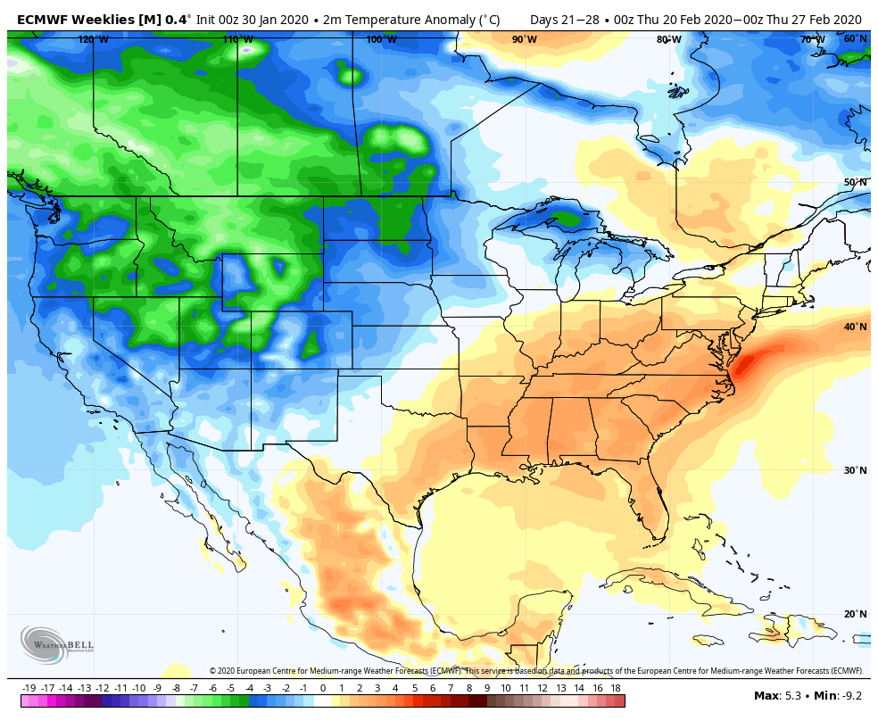
11 minutes ago, yoda said:
lol the Caps play so much different when Samsonov is in goal than when Holtby is
Case in point, look at period 1 vs NSH and period 1 vs OTT
Thats the same thing I was thinking. Not sure why but the defense seems better when Samsonov is in.
-
20 hours ago, nj2va said:
Holts is struggling big time...but hopefully he gets this out of his system. Samsonov has been crazy good for us. Hopefully there'll be some good fights at that Flyers game (I mean on the ice that is ha).
Looking forward to it. My wife and I are spending the weekend in DC for a Much needed getaway . Kids are staying with their grandparents.
The way Samsonov has played its makes the decision easier letting Holtby go after the season. Ive heard they wont have the cap space to resign him.
I've also heard rumors that they could trade him at the deadline to get something for him, but that would be crazy heading into a hopeful stanley cup run with a rookie goalie and Copley as the backup.
-
3 minutes ago, Weather Will said:
I will not clutter the forum with percentage maps. I plan to post the 0z EPS and 12z EPS. I want snow as well so it hurts me as much as it hurts others that want snow. I view the maps as a quick and dirty way to see if an event is in sight. Nothing more should be read into it.
I know others dont care for them but I like seeing them for trends. Thanks for posting them.
Lets hope we are all in the red at some point before winter ends haha.
-
3
-
 1
1
-
-
19 minutes ago, Solution Man said:
They were just a bit off for their January forecast lol
-
 1
1
-
-
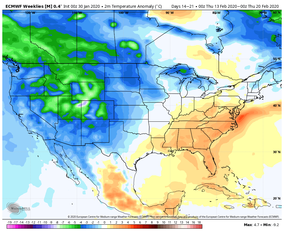
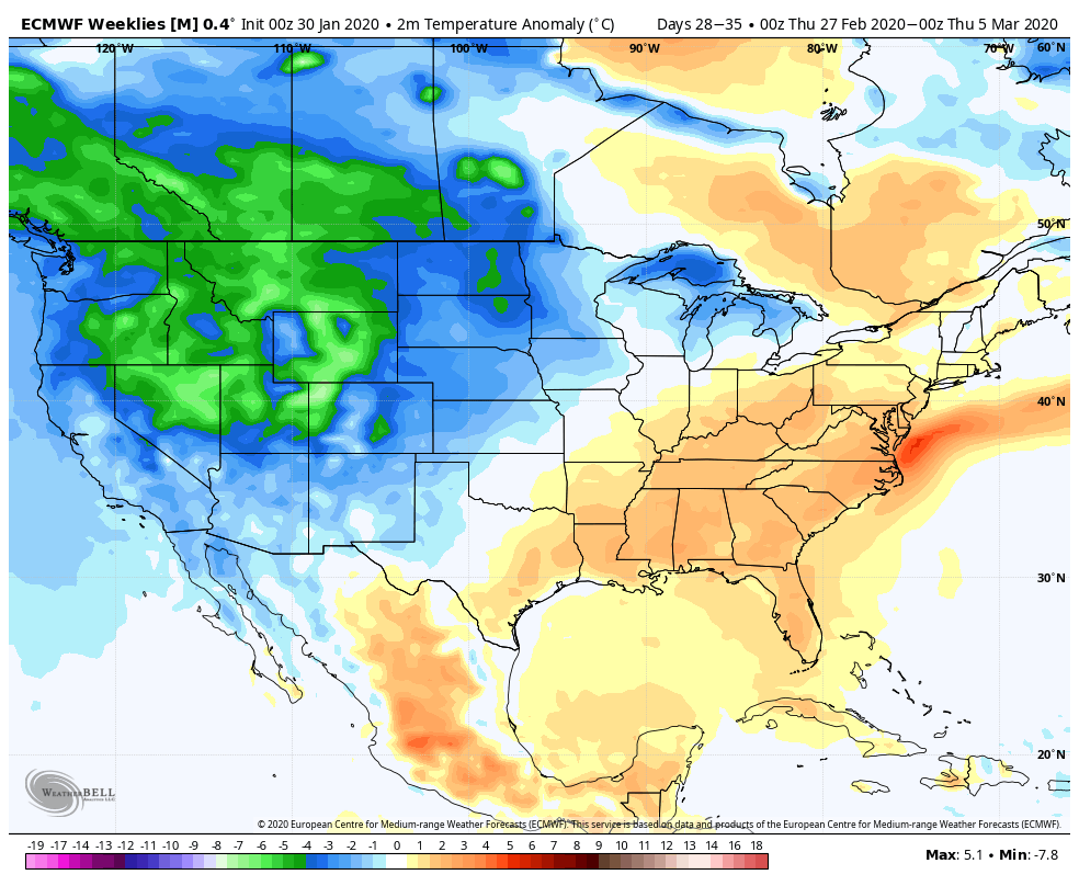
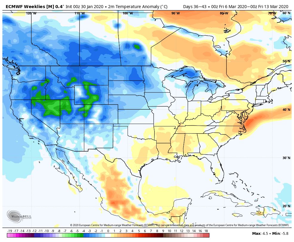
Just now, psuhoffman said:
Weeklies
week 3

week 4

week 5
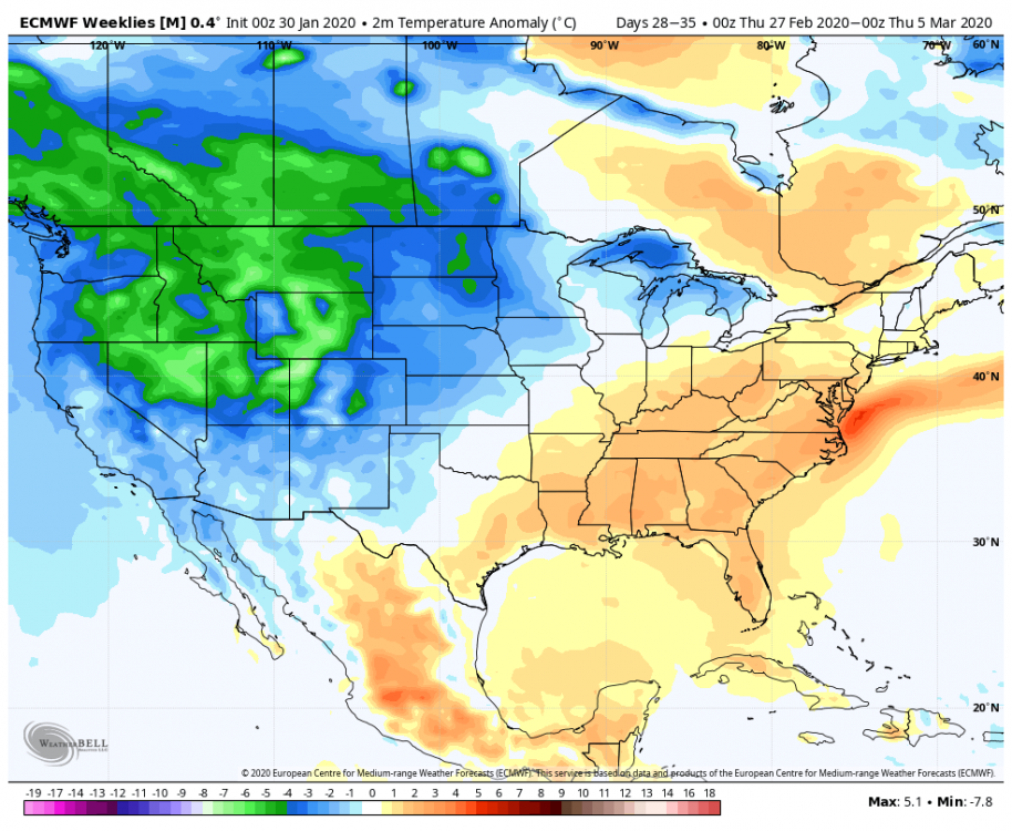
week 6

but they flip the pattern around March 15 so we can enjoy a cold miserable spring!!!

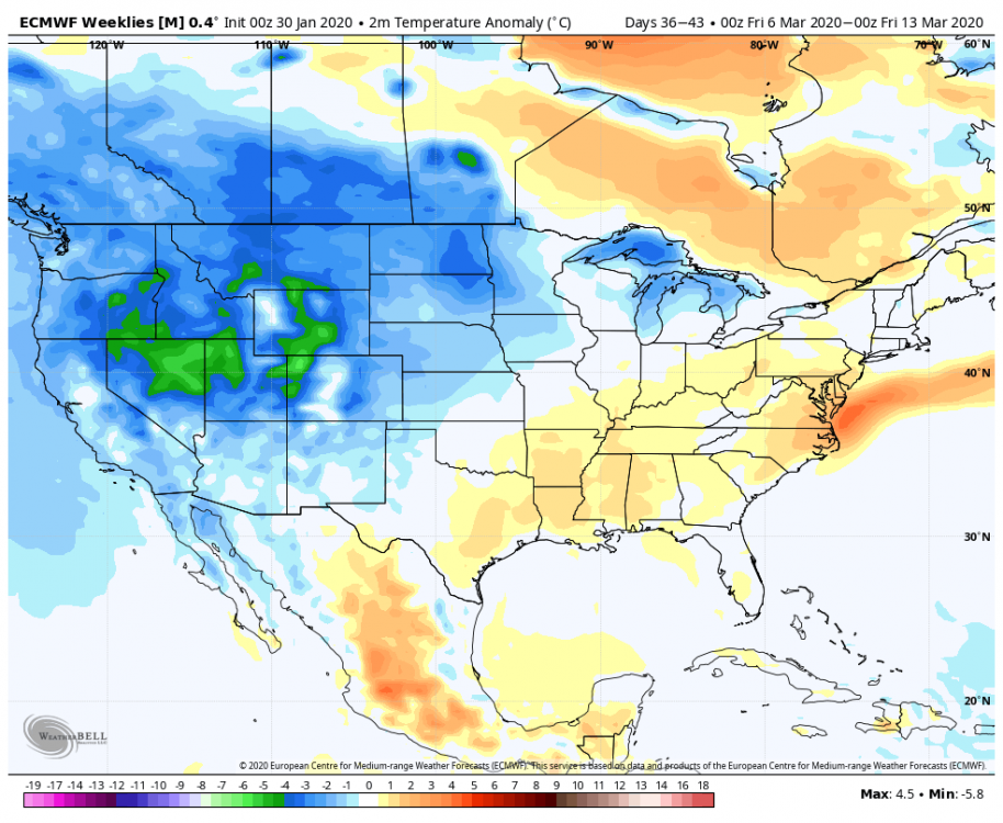
Pull down the shades lol
-
1
-
1
-
-
Just now, Ralph Wiggum said:
Man, what could have been. I guess it is still possible though very unlikely. If we were just to the N side of the gradient the next 5-15 days we would have made a run at seasonal averages if not exceeded them. Almost steady train of moisture.
I could see areas that end up on the right side getting a couple feet of snow during that 2 week period from several waves. Could be vermont and Maine though lol
-
2 minutes ago, stormtracker said:
Bitch ass SE Ridge
I would of thought the wave the day before would of pushed the boundary far enough south east. I guess not in this winter lol.
Euro,GFS and Ggem all look similar for next friday.
-
4 minutes ago, Ji said:
whats going to transfer it to the coast? Our non 50/50 low or our super postive nao?

Atlantic side is awful. Need to get the ridge out west a bit further east
-
1 hour ago, H2O said:
Gotcha. So more Caps talk, less Mdecoy.
Sounds good to me.
So when do they start playing Samsonov more and Holtby less lol.
Holts is struggling big time. Feels like you need to score 5 everytime he's in net.
Going to next Saturdays game against the flyers. Hopefully its Samsomov that night.
-
1
-
-
It really amazes me how good the euro is. Sure it can have big swings the further you go out in time like all models do but once you get to that 4 to 5 day timeframe its generally pretty right. All other models will be against it and they all eventually adjust towards the euro. Not always but in general they all do.
Ive learned over the years not to fully get on board with an event if the euros not feeling it.
-
1
-
-
Just now, nj2va said:
I’m in Dallas on my connecting flight back home. 3 goals in the first doesn’t give me the good feelings.
Good thing Nashville likes to score goals for us lol. They put one into there own goal.
-
1
-
-
@nj2va @Scraff @nw baltimore wx
Looks like its going to be a short night for Holtby
-
4 minutes ago, showmethesnow said:
Coming in here now-a-days it is like coming to watch a...
Lol.
We need an entire subforum warning level event stat!
Nah. Whi am I kidding It might calm things down for 6 hours lol.
-
1
-
-
6 minutes ago, Scraff said:
Nobody talking about the #2 model in the world?

Lol. Looks like the gfs and ggem traded places.
As @WinterWxLuvr stated probably wont know for another day or 2.
Wouldn't surprise me if we get some precip from the system. Always seems to trend north as we close in.
Tenps are brutal. Not sure the precip would be white though lol.
-
Gfs looks alot like the euro now.
-
Lol vorts everywhere

-
1
-
-
2 minutes ago, MD Snow said:
A miss. Not as good at 500. You could tell early on.
Wouldn't really worry about it unless all the other guidance shifts east tonight. Wouldn't take much to get it back at 6z.
H5 much more postive tilted compared to 18z. That made all the difference
-
1
-
-
@nj2va @Scraff @nw baltimore wx
Holtby looking sharp tonight.
-
2
-
-
Got this from another subforum. Im assuming this is the best the GEFS has looked in a while for the weekend.

-
2 minutes ago, Ji said:
The ss vort was much stronger on this run and was able to produce an event without a phase
This. Ill take my chances with 34 degrees and heavier precip.
-
One low in the gulf of main and the other off of NC
-
Gfs brings down a ns vort down the back side of the trough and gets a second low going right behind the initial low lol
-
Just now, WinterWxLuvr said:
6 hours of timing could bring the weekend storm to the forefront of all the discussion.
Im definitely not giving up. So many moving pieces. Especially the northern stream


Mid January/Mid February Medium/Long Range Discussion
in Mid Atlantic
Posted
Was pleaseantly surprised at the number of snowy eps members after next weekend. I know its far out there in time but hopefully its on to something. After basically nothing on eps through next weekend it appears that chances possisbly go up after that.