

Chris78
-
Posts
4,048 -
Joined
-
Last visited
Content Type
Profiles
Blogs
Forums
American Weather
Media Demo
Store
Gallery
Posts posted by Chris78
-
-
Fv3 in lock step with the operational,also showing a close miss to the south.

-
 1
1
-
-
27 minutes ago, C.A.P.E. said:
Happy hour GFS is right where we want it for Dec 9th.
Where it enters the west coast and progresses across the south has mid Atlantic winter storm written all over it. The progression was a thing of beauty for 9 days out. Now if we can just get this look to under 5 days....


-
GEFS looks pretty unanimous for the day 9/10 thing as a coastal. Doesn't support the Ohio valley track whatsoever that the OP shows.

-
1
-
-
1 hour ago, Bob Chill said:
This panel is a good visual. The ns vort helps raise heights in front of the ss vort and screws up the mid levels.

And before someone comes in to tell me not to take a d10 op seriously... I'm not... Just pointing out something to keep an eye on as the whole thing evolves. Obviously there's no way in hell an op is going to nail anything in the northern stream this far out.
Slow the northern stream down a bit and drop it in behind to phase and boom ! Could be fun.
-
1
-
-
Looking through the individual EPS members there's some heavy hitters in there. Also a good amount of southern sliders. I like seeing all of the southern sliders at this range. If there is an actual storm I doubt suppression will be our concern.
-
3
-
-
7 minutes ago, WxUSAF said:
EPS more robust than euro op for the 5th (but still pretty flat) and has a nice setup for D10.
Nice high pressure set up to our north and northwest. Really good look. Too bad it's still 10 days out. Hopefully we still have the same look in 5 days.

-
1
-
 1
1
-
-
Euro looks like a snow to rain deal for the day 10 thing going off of the 24 hour TT maps. Hard to tell off of that though.
-
33 minutes ago, C.A.P.E. said:
Pretty big jump up on the 0z EPS snowfall mean for days 10-12. That is a significant change from previous runs. Hopefully its not just a blip. That seems like the period with the highest chances to produce a winter type storm before the *possible relaxation* (being gentle and optimistic, lol). I am not giving up on next week though. I think we could still sneak in a minor event midweek.
GEFS still advertising a juicy storm system to our south for the 7-9th time frame. That's several runs in a row now.
My one concern would be that high pressure is building in from the west instead of being in place to the north. I would think that would possibly favor suppression but I know it's too early to worry much about details...lol.

-
1
-
-
11 minutes ago, Bob Chill said:
Control run is sweet but multiple good ones this run. Long ways to go but at least we have something to track/discuss.

Would definitely ease the pain to score something prior to things going to sh#t. 2 events prior to December 15th would be a huge win even if we get nothing the rest of December.
-
GEFS very bullish for a storm running the coast Dec 7-9. Hopefully we can score something during this time frame. We may be waiting for a while after that. Lol

-
2
-
-
2 hours ago, Zach’s Pop said:
Yea I hate when it’s cold in December
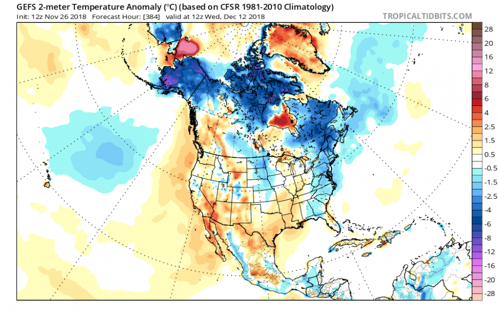
Lol. It's 16 days out so I'm sure it will change many times but if you loop it our cold source region is being flooded with average to above average 2m temps. Definitely not a look that would provide cold air and Snow chances for us. Most of western Canada is a/or above normal.
-
Man, the GEFS and GEPS are both ugly at the end of there runs.


-
Not a bad look heading into the middle of December. I'd take my chances with that.


-
3
-
-
Redskins offense is just awful. No playmakers at all. Doctson is a complete bust for a first rounder. Everyone talks about injuries but every team has injuries. Offense wasn't much better when Crowder and Thompson were both playing. Skins aren't good enough to turn the ball over 3 times and overcome that.
It's going to be a rough 5 games
-
Looks good to me.
Bring on December!!

-
1
-
-
11/15/2018 - 7.5"
-
13 minutes ago, poolz1 said:
@Chris78 I wouldnt be surprised if you were and inch or two higher up there...seems like reports closer to the MD line were a bit more. Thurmont with 8" and Cat Mtn with 9" on the reports.
Thanks.
I think your right. My in-laws live in Thurmont and they said they got 7.5. I'm thinking Smithsburg probably received between 7 -8. Hard to tell at this point with all of the rain on top of it now lol.
-
What was your total accumulation? I've been at work all day and was unable to get any measurements. Our totals should be similar. I'm in Smithsburg.
-
28 degrees with light snow in Smithsburg MD
-
@poolz1 Hagerstown should be able to get down to 27-28 degrees when the heavier precip moves in.
-
GFS is 2 to 4 degrees cooler at the surface across the area compared to 12z. Nice trends for the 18z suite.
-
2
-
-
The rgem is a heck of a snow/sleet storm for I - 81 corridor.
Frozen precip noticeably further south and east.
-
3 minutes ago, Bob Chill said:
18z 3k went a little colder in the mids than 12z. Step in the right direction at least...
Mesos taking a step towards the euro?
-
Still quite the difference between the GFS and Euro and were less than 18 hours to go time.
Stark contrast for sensible weather and travel conditions, etc
In guessing reality will be somewhere in between the 2 models.


November/December Medium/Long Range Disco
in Mid Atlantic
Posted
GEFS still showing a southern slider. At this range I'm good with that. It's just following the op. Id rather have this than it showing a Detroit blizzard.