

Chris78
-
Posts
4,048 -
Joined
-
Last visited
Content Type
Profiles
Blogs
Forums
American Weather
Media Demo
Store
Gallery
Posts posted by Chris78
-
-
850's below 0 n+w of dc through out but surface is torching. Upper 30's to around 40.
-
Just now, nj2va said:
The best part of the GFS is that if you don’t like the OP just look to the FV3 which seems to be the snowier brother to the OP. Wonky NCEP maps show precip getting to DC with 850s below 0. Waiting on TT to see just how much...
Do you have a link to the ncep maps?
-
14 minutes ago, WxUSAF said:
I've had the same feeling for awhile (i.e., that after Xmas we'd be in a step back to a more typical Nino pattern and cold air), but it keeps getting pushed right. Likely the MJO being in Phase 4-5 for so long is the prime culprit. But Christ seeing the can kicked once again with another Pac jet extension showing up after whatever happens on the 3rd/4th is frustrating for sure.
If we can score something around the 3rd or 4th it would make the following week much more bearable until the pattern hopefully gets right for good after the 15th or so. If we don't score something in the first 4 or 5 days of January it might take to the last 10 days of month. I didn't think December was going to be off the charts great but I also didn't think I would be waiting 2 months between seeing snowflakes...lol
-
8 minutes ago, NorthArlington101 said:
Rain is the predominant solution. GEFS backed off from its 06z run.
Good news for rain enthusiasts though, the mean precipitation is an additional 2.5' right through DCA and BWI before the New Year!
At this range the GEFS will play follow the leader. GFS showed rain so it's not surprising the members are also showing rain. I agree the best bet will be wet not white but the fv3 is very close to some snow atleast at the onset.
-
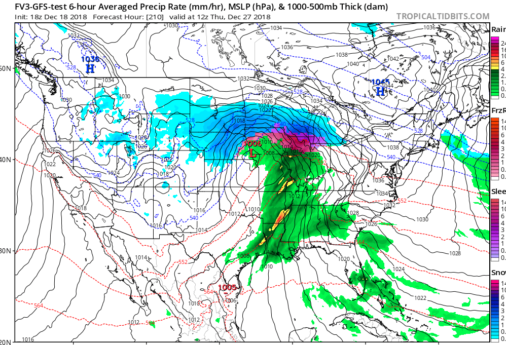
Fv3 doesn't have the best snow algorithm but this shows how close we are to something good.

-
Fv3 so close to a good hit for the pre NYE threat. We need about a 50 to 100 mile shift for the cold push and we would be in business. Fv3 is basically a 3 to 6 inch storm up in central/southern pa

-
12 euro looks close for 12/30 Just going off of TT. Looks like a good track for the weak low that skirts under us. Hard to tell though from the 24 hour maps
-
1 minute ago, Bob Chill said:
Gefs playing follow the leader.

Wow! That's very good agreement. If the 18z shows a cutter then all the mini me's will show a cutter also lol.
Seems like inside of 10 days there's not much spread.
-
The models are having a hard time fiquiring out how much energy to send out of the SW. The runs that are giving us a chance at multiple events are sending it out in pieces. The runs that wait and send it all out at once cut way west nd rain on us. Seems to be flipping every model run
Njaed by 87storms
-
 1
1
-
-
How does the individual members look on the GEFS for the NYE threat? The mean looks ok on TT.
-
Happy hour delivers!

-
4
-
-
1 minute ago, Cobalt said:
Snow mean shows, nearly 3.5" for DCA increasing to points NW
Is that for the day 10 to 15 period?
-
GEFS continues to key in on the threat around the 1st. Would be a great way to start out the new year.


-
1
-
-
10 minutes ago, Ji said:31 minutes ago, midatlanticweather said:This looks a little different from yesterday's Happy Hour! I do see the CAD set up - something frozen is better than none for some!
Different storm bro
Here's our happy New Year rain storm.

-
 1
1
-
-
Not an awful look at the end of the Run. Not there yet but you can see it heading in the direction we want.

-
1
-
-
Just now, BristowWx said:
Might have to drink a few more glasses of champagne if that rang true.
I'd drink a few more bottles if that happened lol.
-
Just now, Maestrobjwa said:
As do I...the window isn't WIDE open...but unlike 90% of our Christmases...it definitely ain't shut either! Will be interesting to see how it evolves...
Yep. Because it ain't pretty right after our 2-3 day threat window.
-
I still have hope for something around Christmas. We're not that far off from a small/med. Event.
Nice high pressure to the north and Northwest.

-
2 hours ago, Eskimo Joe said:
Long range outlook is about as ugly as it gets. All the fake TV mets in the Baltimore and DC markets that called for a big winter (cough, Doug K, cough) are in trouble.
I think we can still have a good winter but I have always thought to have a special winter would require us to score a time or 2 in December. I was hoping the AO was going to be more in the negative territory for December. That is concerning to me.
-
 1
1
-
-
1 minute ago, Ji said:
GGEM looks eerily similar to the Richmond/Greensboro storm smh

That actually looks like a good set up.
-
GEFS white Christmas??


-
1
-
-
Great write up as usual @showmethesnow. I enjoy reading your write ups in the morning.
I agree that if we can lessen the dump into the SW there may be just enough cold air around for Christmas to deliver white rather then wet.
-
1
-
-
-
1
-
-
I'm waving the white flag for this weekend. Hoping for stronger confluence for next weekend. Next Saturday/Sunday has my interest.
-
1
-


December/January Medium/Long Range Discussion
in Mid Atlantic
Posted
Agree. Great track.
Cmc has a track west of us like the Euro did. Hard to have much faith in the GFS details being correct with as much flip flopping as it's done.