Tullioz
-
Posts
2,469 -
Joined
-
Last visited
Content Type
Profiles
Blogs
Forums
American Weather
Media Demo
Store
Gallery
Everything posted by Tullioz
-

January 20-22 “bring the mojo” winter storm threat
Tullioz replied to lilj4425's topic in Southeastern States
Looks like it may be trying to make a comeback.
-
Winter Storm Izzy Obs Thread
Tullioz replied to Prismshine Productions's topic in Southeastern States
23.9/10.2 Light snow in Eden. -
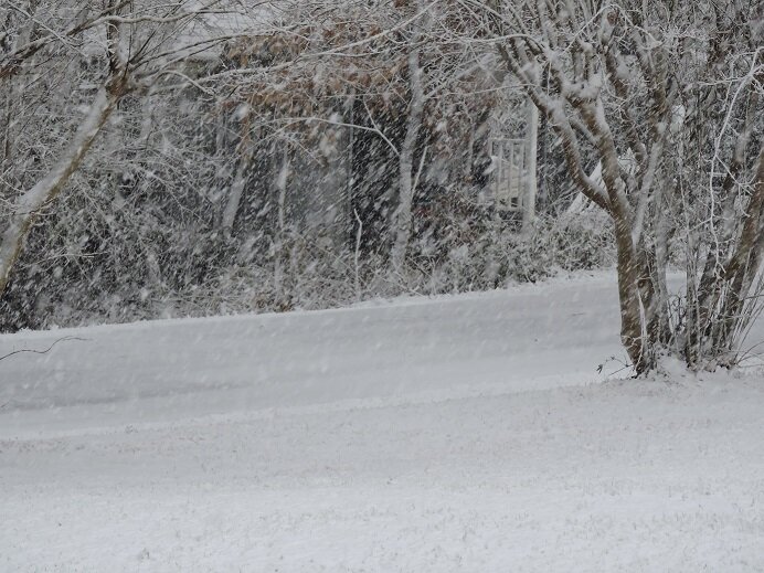
Snow is winding down now. Measured between 2" and 2 1/2". 32.4/32.1
-
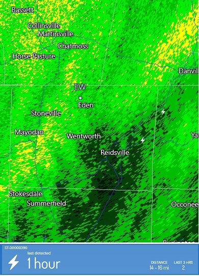
It showed up on Radarscope and was picked up on my weather station here in Eden.
-
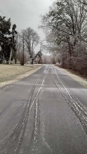
32.0/31.8 The road in front of the house is now covered.
-
Rain/snow mix in Eden. 33.8/33.5 Had a wind gust of 43mph at 6:34am
-
Unfortunately the Philippine government isn't allowing most foreign nationals into the country at this time. Even if Josh were to fall into one of the limited categories allowed entry, he would have to undergo a minimum 6-day quarantine which would have made it pretty much impossible to chase Typhoon Rai. There are also travel regulations on the local level that vary from one jurisdiction to the next that would have added to the difficulties of chasing.
-
Mid-Atlantic winter 2021-22 snowfall contest
Tullioz replied to AnEndlessMaze's topic in Mid Atlantic
BWI: 22.5" DCA: 16.3" IAD: 21.1" RIC: 11.8" LYH 15.3" -
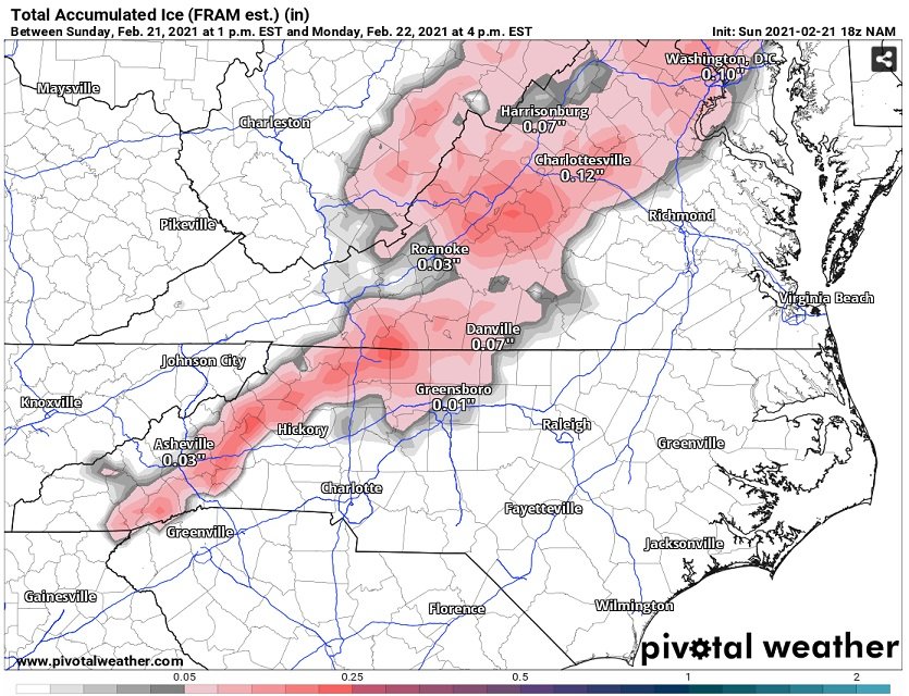
The NAM shows many in western NC, the NW Piedmont of NC. and up into Virginia having a chance of at least a light glaze early tomorrow before a changeover to rain.
-
February 18-19 MAJOR Ice Storm Threat
Tullioz replied to NorthHillsWx's topic in Southeastern States
It doesn't do well in situations like today. For example, I have measured .59" with my Davis weather station, and only .06 with the tempest. The wind is probably off also due to the restricted air flow from ice, but I don't have anything to compare it to since my Davis station is frozen up. Rain measurements have always been off with my Tempest station. Often more than 50% compared to my Davis and simple manual tube type rain gauge that I use.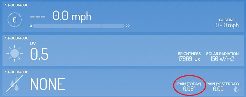
-
February 18-19 MAJOR Ice Storm Threat
Tullioz replied to NorthHillsWx's topic in Southeastern States
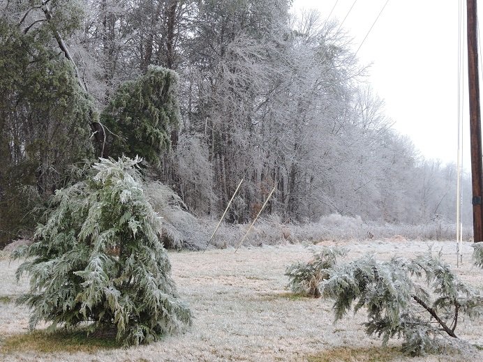
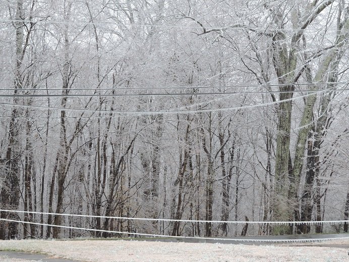
Just a stones throw from your location outside the city limits I'm currently sitting at 32.4/32.4 with a light drizzle. I also measured .59" in the rain gauge. There's been a lot of melting taking place, but there's still plenty of ice around. The pictures below were taken less than 5 minutes ago. I think the wind may be gusting higher than the 4 to 6mph I reported earlier since the air flow to my Tempest station has about a 50% blockage. My Davis station hasn't shown any wind readings for hours for obvious reasons.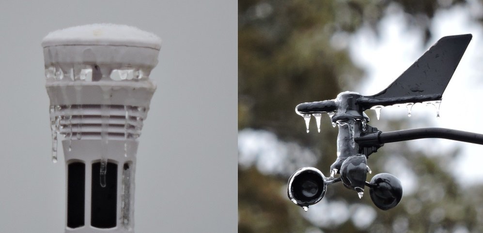
-
February 18-19 MAJOR Ice Storm Threat
Tullioz replied to NorthHillsWx's topic in Southeastern States
Just reached the melting point at my location. 32.0/31.8 -
February 18-19 MAJOR Ice Storm Threat
Tullioz replied to NorthHillsWx's topic in Southeastern States
The point and click forecast for my area still shows this: https://forecast.weather.gov/MapClick.php?CityName=Eden&state=NC&site=RNK&lat=36.5057&lon=-79.7422#.YC6d0-hKhPa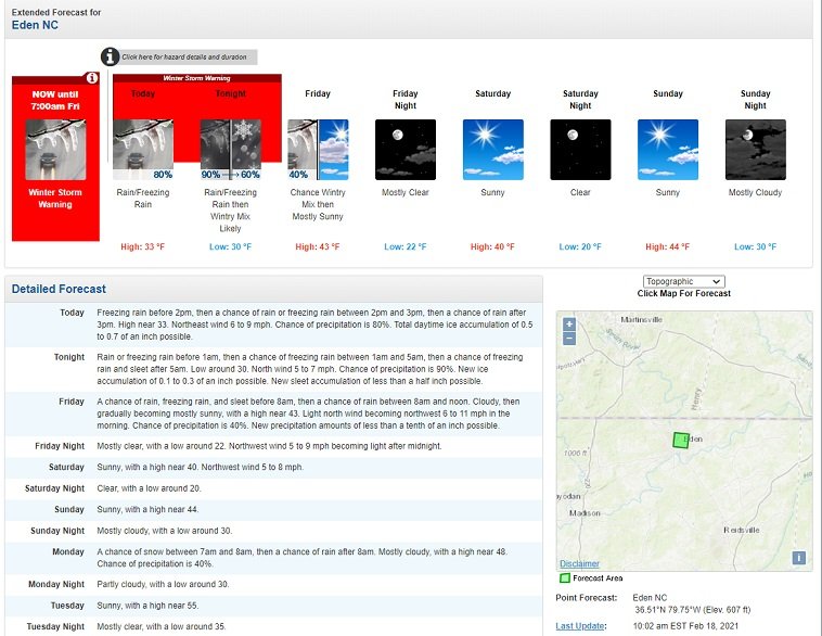
-
February 18-19 MAJOR Ice Storm Threat
Tullioz replied to NorthHillsWx's topic in Southeastern States
Yeah, I was expecting winds in the 15 to 25mph range by now. I did have a gust of 6mph around 10am and currently the winds are gusting to around 3mph. Lol It's about as close as you can get to dead calm outside at the moment.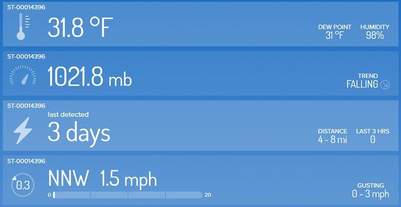
-
February 18-19 MAJOR Ice Storm Threat
Tullioz replied to NorthHillsWx's topic in Southeastern States
I'm back to freezing rain with lighter radar returns overhead. Had enough sleet to make the roads slushy. I measured right around .20" ice accrual on elevated surfaces, so we're not too far away from meeting Winter storm criteria here.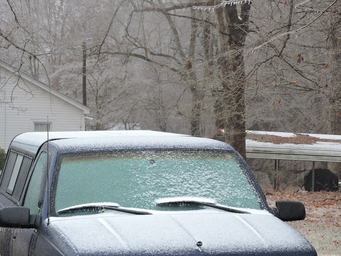
-
February 18-19 MAJOR Ice Storm Threat
Tullioz replied to NorthHillsWx's topic in Southeastern States
Mostly sleet now. Temperature continues to rise. Up to 31.3 now. -
February 18-19 MAJOR Ice Storm Threat
Tullioz replied to NorthHillsWx's topic in Southeastern States
This heavier band of precipitation that is moving through now has some sleet mixing just west of Eden. -
February 18-19 MAJOR Ice Storm Threat
Tullioz replied to NorthHillsWx's topic in Southeastern States
So far I have seen about .10" on elevated surfaces and the grass is crunchy when walked on. Roads have no issues. The temperature and dew point have been slowly rising since 6:15am when they were at 29.8/29.1. Currently 30.6/29.8 -
February 18-19 MAJOR Ice Storm Threat
Tullioz replied to NorthHillsWx's topic in Southeastern States
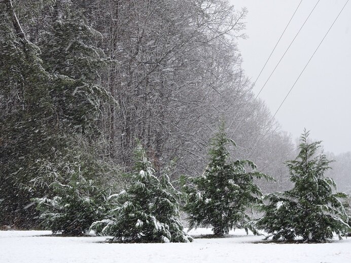
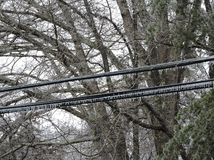
Since my previous post my temperature has dropped to 29.8 which is already lower than the lowest temperature reached during the last event which was 30.2. The dew point is at 27.9, so there's still room for the temperature to drop lower. There's a light glaze on all elevated surfaces already. Radar is filling in quickly and looks good down stream for some significant precipitation amounts in this area by the time all is said and done. This will no doubt be a more severe ice storm than the last one for my area. -
February 18-19 MAJOR Ice Storm Threat
Tullioz replied to NorthHillsWx's topic in Southeastern States
Precipitation started as rain at my location just west of Eden within the past ten minutes and the temperature and dew point have responded. Was: 33.6/23.1 at 1:50am Now: 31.5/27.6 2:15am Wind: NNE - 8 -
February 18-19 MAJOR Ice Storm Threat
Tullioz replied to NorthHillsWx's topic in Southeastern States
33.8/23.6 with mostly cloudy skies. Winds are light and variable. -
It may not have been a record, but the ice storm that occurred February 10-11,1994 had some pretty impressive accumulations of ice in NC. It was by far the worst ice storm I ever experienced. In my weather journal I recorded two inches of snow/sleet and 1 1/4" of ice accrual. I was without power for nine days. There were higher amounts of ice reported across the state (Up to 2") and many went without power longer than I did. Here's a link to a short summary of that event: https://climate.ncsu.edu/climate/winter/event_details?e=132
-
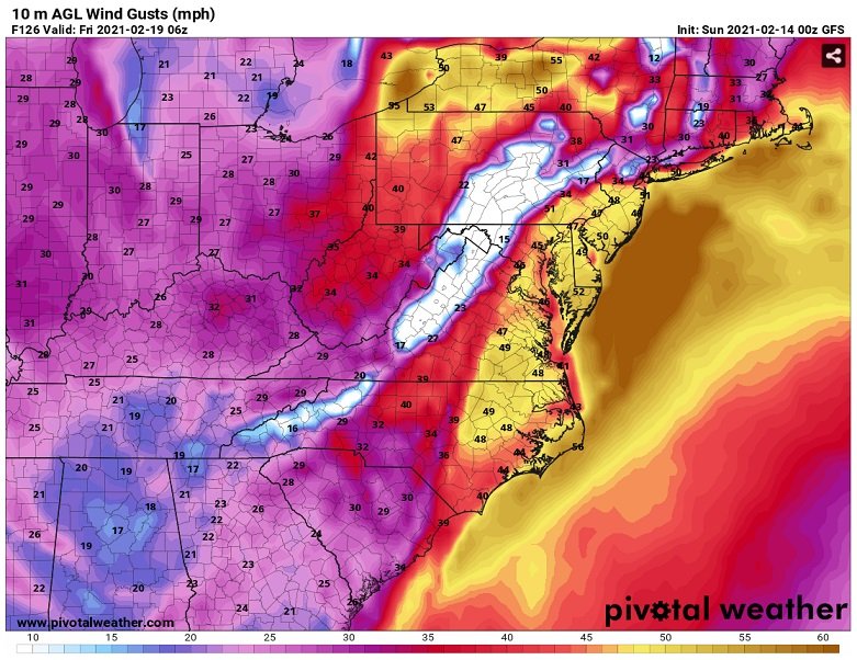
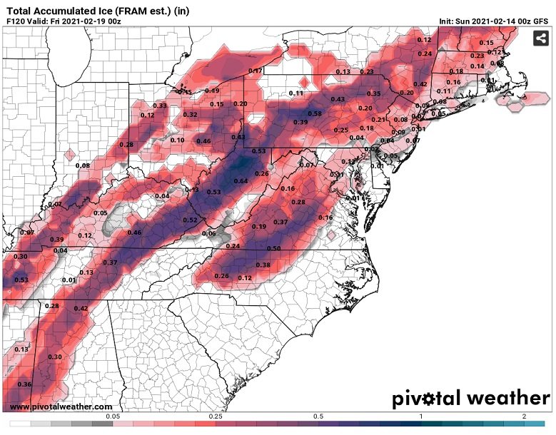
The 0Z GFS looks concerning. The combination of super saturated ground, significant icing, and strong winds as shown would be disastrous for much of the northern foothills and piedmont of NC into southside Virginia.
-
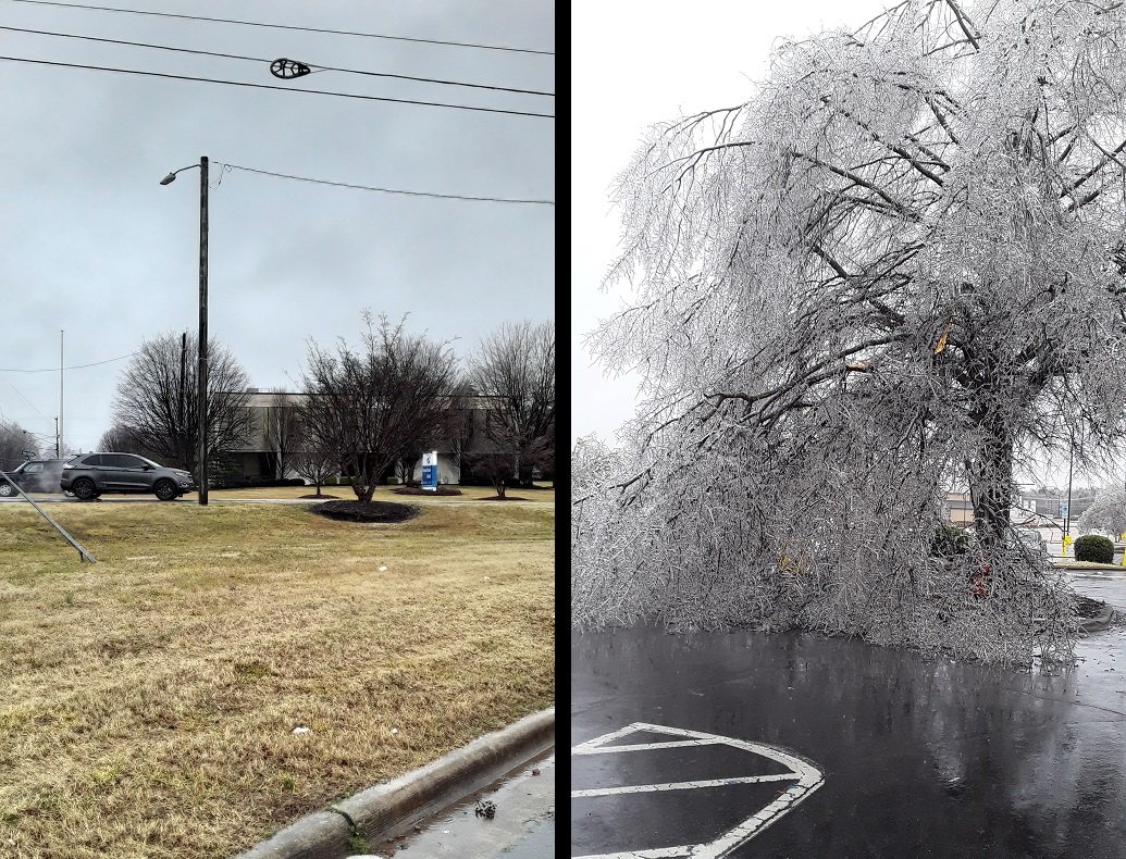
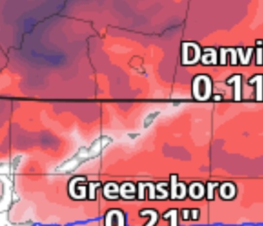
The temperature at my location just west of Eden went above freezing at 6:20am and currently sits at 32.9. I ended up with right at .10" ice accumulation on trees and elevated surfaces. Driving around Rockingham County and into the Ridgeway area of Henry County VA earlier I found ice accumulations that varied from only a trace in the center of Eden, to as much as .30" in the Wentworth and Western Reidsville areas. Ridgeway had what appeared to be between .25 and .30". The only place I took the time to get out of the car and measure was in Reidsville. The picture below shows Eden at the intersection of NC Hwy 14 and Stadium Drive on the left where little if any ice accumulation can be seen, and a picture from Reidsville near the intersection of Business Hwy 29 and US Hwy 158 on the right where I measured .30". I have seen this scenario play many times over the years where inside the city limits of Eden only marginal accumulations of ice occur while areas immediately surrounding the city have significant amounts. I have found that the HRRR and the 3k NAM usually do well with the topography in this area, especially in situations involving freezing rain. For example, below is an image from the HRRR where the Dan River Basin shows up quite well. It's easy to identify where the Dan River flows out of Patrick County Virginia into Stokes County, and the Mayo and Smith Rivers flow out of Henry County Virginia and feed into the Dan in Rockingham County. Driving around today I was able to confirm that both the HRRR and the 3K NAM did very well in identifying what locations would see the highest accumulations of ice from this event.

-
Light freezing rain and a slowly rising temperature just west of Eden. Currently 31.1/30.9 Was 30.2/29.7 at 5pm.