Tullioz
-
Posts
2,469 -
Joined
-
Last visited
Content Type
Profiles
Blogs
Forums
American Weather
Media Demo
Store
Gallery
Everything posted by Tullioz
-
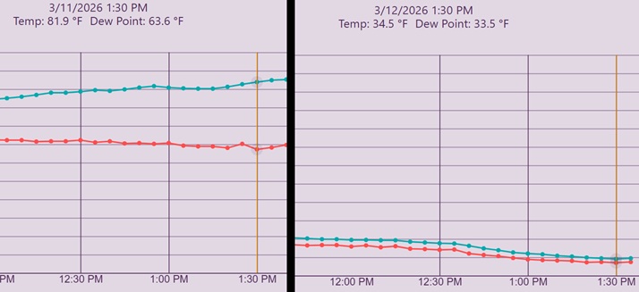
What a difference a day makes. Yesterday at 1:30 pm it was 81.9°. The high was 85.6°. Today, it's 34.5° with snow falling at 1:30 pm, after a high of 74.5° at 12:30 am.
-
Rain and sleet with a few wet snowflakes mixed in just west of Eden. 38.6°/37.2°
-
Nine out of the last ten years Eden has seen the temperature drop below 30° in April. 28.4° April 9, 2025 28.4° April 7, 2024 29.7° April 11, 2023 28.6° April 20, 2022 29.4° April 23, 2021 28.8° April 12, 2020 29.1° April 3, 2019 28.6° April 9, 2018 26.6° March 10, 2017 26.3° April 11, 2016 The latest date the temperature fell below freezing during this ten year period was May 11, 2020 when it dropped to 30.3°.
-
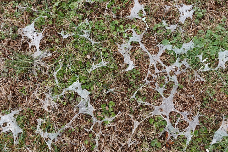
I had a very mild morning low of 45.9° after a high yesterday of 66.2°. This morning was the first since January 14th that the temperature didn't fall below freezing overnight in my backyard. Yesterday was a big snowmelt day and in its wake, I have noticed a few patches of snow mold.
-
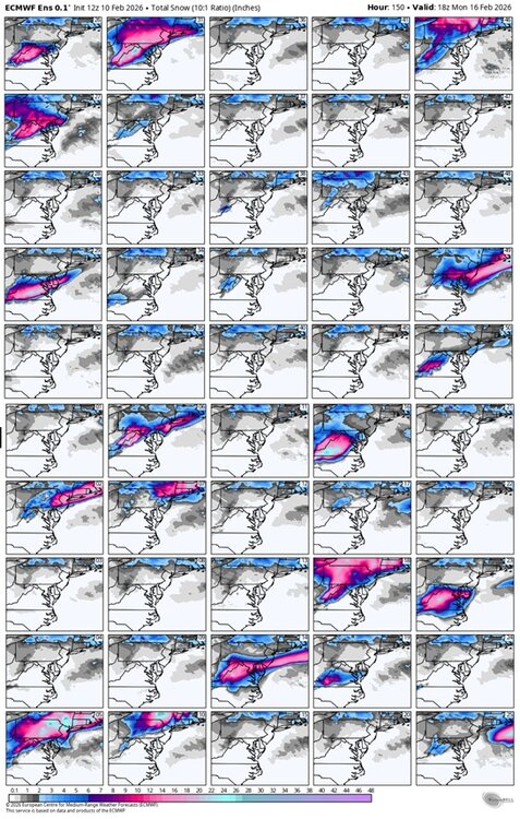
If you look at the ensembles, you will notice there's also a lack of cold air at the surface and aloft to support snow in south-central Virginia.
-
There are only a handful of ensemble members showing snow in south-central Virginia. Of those, there are a few outliers showing significant amounts of snow, and they are skewing the snowfall mean.
-
Light to moderate snow just west of of Eden. 38.8°/27.5°
-
My morning low just west of Eden was 4.1°. There were several other locations in Rockingham County that were colder. The coldest temperatures I could find were in the Madison area, where two personal weather stations, KNCMADIS60 and KNCMADIS38 dropped to -4.5° and -3.5°, respectively. KSIF dropped to 2.3° at 7:35am. Both the Dan and Smith rivers are frozen over in several locations. The first picture is of the Dan taken from the Hwy 87 bridge, and the second, the Smith taken in North Spray. I've only seen this much ice on the rivers a handful of times over the years. In January 1985 Eden saw temperatures fall well below zero a couple of nights, and highs only reached the mid-teens during the day. This is also when I recorded the lowest temperature in Eden since I first began keeping records in 1981. I had a morning low of -11° on the 21st and -6° on the 22nd. I was much younger and foolish back then, and my friends and I walked across the Smith River during that cold spell. The pictures below were taken on January 23, 1985 and are of me standing in the middle of the river and my friend Robert as he was walking across.


-
I've measured 8.6" just west of Eden. Snow has tapered off to just a few light flurries, so this will likely be the final storm total. 16.0°/14.1°
-

January 30th- Feb 1st ULL and coastal storm obs
Tullioz replied to JoshM's topic in Southeastern States
7.7" just west of Eden. Moderate to heavy snow right now. 17.1°/16.1° -
January 30th- Feb 1st ULL and coastal storm obs
Tullioz replied to JoshM's topic in Southeastern States
4.1" of snow so far just west of Eden. Light to moderate snow continues. 15.4°/13.8° -
January 30th- Feb 1st ULL and coastal storm obs
Tullioz replied to JoshM's topic in Southeastern States
2" on the ground just west of Eden. Light to moderate snow continues to fall. 15.1°/13.4° -
January 30th- Feb 1st ULL and coastal storm obs
Tullioz replied to JoshM's topic in Southeastern States
Light snow continues just west of Eden. Measured 0.5". 23.7°/21.8° -
January 30th- Feb 1st ULL and coastal storm obs
Tullioz replied to JoshM's topic in Southeastern States
Very light snow just west of Eden. 27.7°/19.8° -
Southern Crippler - Get well soon Jimbo Storm Obs
Tullioz replied to BooneWX's topic in Southeastern States
Very light snow just west of Eden. 20.4°/2.5° -
Wow.
-
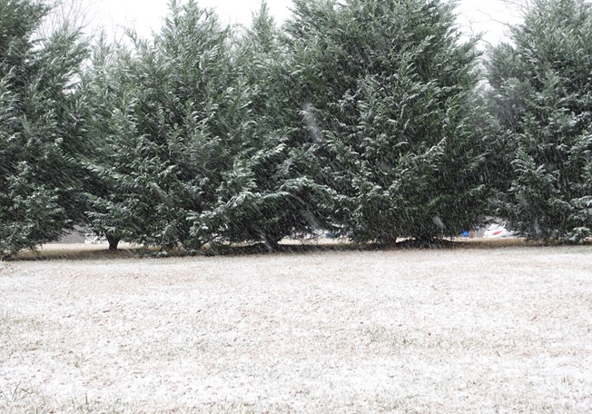
This turned out to be a nice little event IMBY. The snow fell at a decent rate for around an hour. This, along with the temperature quickly dropping below freezing, allowed for a light accumulation. Currently sitting at 31.6°/29.3°.
-
Light snow just west of Eden. 37.4°/28.9°
-
I never said otherwise; in fact, when replying to a member who said, "I guess snow falling from the sky without accumulating is considered measurable nowadays," I replied with, "Measurable snow is considered .1" or more." The comment I was addressing was "not even a single trace, much less multiple instances" had occurred in the Hickory/Catawba County area. I replied to that comment saying that there had been multiple reports on social media of snow falling on different dates, which confirms that at least a trace of snow had fallen on more than one occasion so far this winter. I think most would agree that seeing snow falling on three or four separate occasions at any given location in NC outside of the mountains before mid-December, even if it melts on contact, is impressive.
-
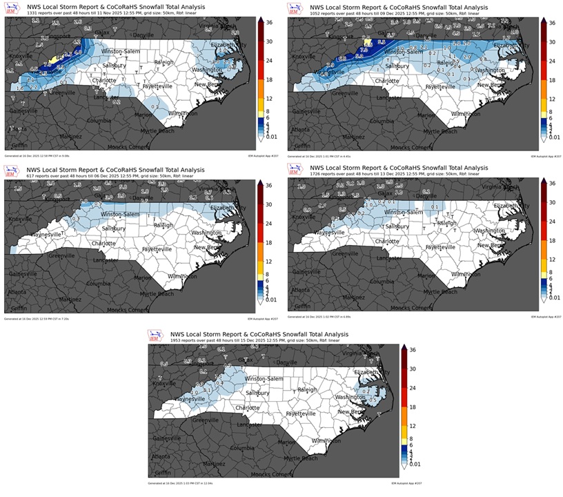
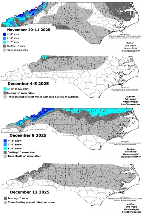
There was definitely a trace of snow that fell in the Hickory/Catawba County area on November 10th, December 8th, and December 12th. There were multiple reports on social media of snow falling on those dates.
-
Measurable snow is considered .1" or more. Looking at the IEM maps, it appears most of the state has seen at least .1".
-
Those maps are a bit more generous than the IEM maps shown below; regardless, most of NC has seen measurable snow.
-
-
The temperature at my location just west of Eden bottomed out at 8.4° at 7:30 this morning. This was only half a degree from the coldest temperature I recorded last winter, which was 7.9° on January 23rd. The coldest temperature I could find in Rockingham County was 7.2° at a location about halfway between Eden and Stoneville. KSIF recorded a low of 9.7° at 7:15am.
-
It's been snowing lightly here since around 7am. Seeing the heaviest rates of the day right now, but looking at radar it should be coming to an end very soon. 34.7°/30.1°