ILSNOW
-
Posts
1,606 -
Joined
-
Last visited
Content Type
Profiles
Blogs
Forums
American Weather
Media Demo
Store
Gallery
Everything posted by ILSNOW
-
I remember a time when December rolled around we actually had storms to track and it would actually snow. These days we impatiently wait for our 2 week window in mid January where we will have a couple of near misses as the arctic air suppresses the storm south of us and Oklahoma City gets a foot of snow. We will then proceed to warm back up until we get a few inches of snow in April. I do miss the good times of following every model run!!!
-
Chicago NWS Lake IL-Northern Cook-Central Cook-Southern Cook- Including the cities of Waukegan, Buffalo Grove, Mundelein, Gurnee, Evanston, Des Plaines, Schaumburg, Palatine, Northbrook, Chicago, Cicero, Oak Lawn, Oak Park, La Grange, Calumet City, Oak Forest, Lemont, Orland Park, and Park Forest 245 PM CDT Tue Oct 31 2023 ...WINTER WEATHER ADVISORY IN EFFECT FROM 6 PM TO 11 PM CDT THIS EVENING... * WHAT...Burst of accumulating snow expected. Total snow accumulations of 1 to 3 inches. Winds gusting as high as 45
-
Great writeup by Ricky on the flash flooding potential The 12z HREF LPMM notably features some pockets of 3-5" of rain, with ensemble max hinting at upside potential being 5-7" amounts where repeated rounds of intense convection occur. See WPC`s recent MPD for additional thoughts on this. We`re looking at a decent chance of issuing a Flood Watch once convective trends have shown their hand more conclusively.
-
Chicago NWS There are increasing concerns that isolated to scattered thunderstorms develop a bit earlier in the afternoon along the backdoor front/lake breeze boundary. Have nudged up the start time of the thunder mention (VCTS) to 22Z for all terminals due to the anticipated northwest to southeast orientation of the boundary. There is a low chance (20 percent) that storms develop as early as 21Z over the Chicago metro terminals. There remains greater confidence in a separate cluster or line of severe thunderstorms that develops to our northwest and progress southeast across the area during the evening hours. While severe weather is possible with any storms that develop today, the more organized severe wind threat would likely be tied to the evening convection.
-
big fatties flying and starting to stick on grass. Edit: 455pm backed off considerable
-
started as snow here flake size is getting larger
-
12z EPS and snow depth
-
RC .UPDATE... Issued at 1140 AM CST Wed Mar 8 2023 No changes were made to the Winter Storm Watch in effect for the Wisconsin state line counties. The key points from the early AM AFD remain similar and there`s still generally speaking two camps, the higher QPF and snow NCEP guidance (including some but not all CAMs) and the lower QPF and snow foreign guidance. Heaviest precipitation rates, possibly including some rain at onset, look to be mid-late Thursday afternoon into the early evening. Part of that includes daylight hours and temperatures starting a few to several degrees above freezing, so it`s uncertain how long heavier snow rates will take after onset to result in pavement accumulations and worsening impacts. Thinking is that decisions on the winter headlines should be able to be made this afternoon after assessing the rest of the 12z model cycle data, which primarily is the ECMWF and its ensemble at this point. Castro
-
yep nice to look at the NAM (Never Accurate Model)
-
Winter 2022/23 Medium/Long Range Discussion
ILSNOW replied to Chicago Storm's topic in Lakes/Ohio Valley
Garbage model -
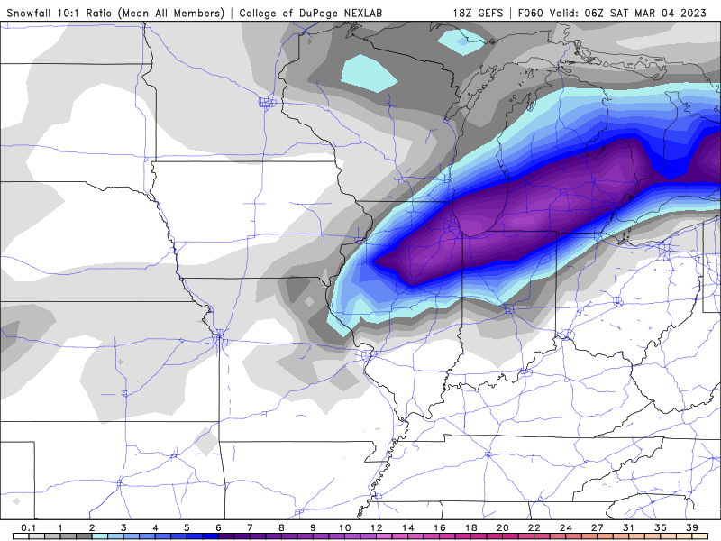
18z GEFS for those getting the snow enjoy.
-
Right. Clearly the NAM is onto something and will prove correct making the Euro, GFS, GEM,RGEM, ICON,JMA, NAVGEM and JMA all wrong. and 18z HRRR
-
best Model and this is the lower snow depth output. What a joke!!!
-
thanks
-
Maybe RC or Chicago Storm can share if the have it.
-
12z EPS
-
good luck to folks south and east of here enjoy !!!!
-
12z NAM apparently didnt get the message. Why is this model even around any more. We are within 24 hrs of a potential storm and most models have no precip in the Chicago area and this model has a 13 inches . It should be replaced by a dart board. At 18z is will go from 13 inches to 0.
-
so Chicago goes from WSW to partly sunny highs in the low 40's!!!!!
-
Euro caves
-
0z GEFS
-
NAM hasn’t gotten the south and east memo (YET)
-
Would love to see EPS if you can share
-
Euro goes south and east
-
yes the mean remains NW of the op run