

ILSNOW
-
Posts
1,644 -
Joined
-
Last visited
Content Type
Profiles
Blogs
Forums
American Weather
Media Demo
Store
Gallery
Everything posted by ILSNOW
-
12z UKMET really focuses on the possible lake enhancement.
-
Thinking Chicago NWS would like to go with WWA instead of WSW for the entire area.
-
12z NAM depiction of ALEK duster
-
In ICON we trust
-
0z NAM
-
18Z Euro slightly drier
-
and Milwaukee In addition to storm track and strength, there are a couple of other uncertainties associated with Wednesday`s system. First, as east to northeast winds become better focused early Wednesday, and winds then turn more northerly during the day, lake enhanced snow is possible for locations near Lake Michigan, particularly from Milwaukee south toward Chicago. This could result in higher totals for this area. Second, SLRs look to be above average for much of this event, meaning this should be a dry and fairly fluffy snow. However, several factors have to come together just right to generate these higher SLRs, so any deviation could result in lower snow amounts. For now kept SLRs around 15:1 for this event, which is above climatology of 12:1, but lower than what some guidance is showing (closer to 20:1).
-
Izzi Unfortunately, as far as amounts go, there remains uncertainty in regards to specific totals. The uncertainty is driven largely by the questions in regards to the snow:liquid ratios (SLRs), with climo for southwest originating storms and the Cobb method both favoring SLRs closer to 10 to 11:1. NBM guidance is substantially higher, closer to 14-18:1, highest northwest CWA. For this forecast have split the difference between the 2 extremes, though forecast soundings (particularly in the warmer NAM) show a fairly deep isothermal layer closer to the -5C with the heavier precip, which would tend to favor more aggregates and lower SLRs.
-
12z GEM going all in totals for BOTH storms
-
Winter 2024-25 Medium/Long Range Discussion
ILSNOW replied to michsnowfreak's topic in Lakes/Ohio Valley
12Z GEFS total for run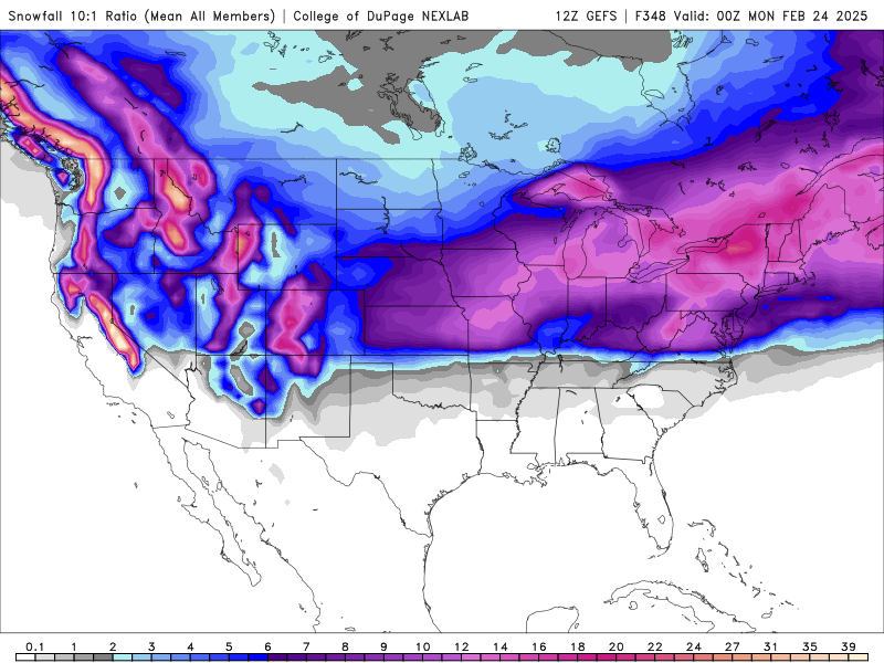
-
Winter 2024-25 Medium/Long Range Discussion
ILSNOW replied to michsnowfreak's topic in Lakes/Ohio Valley
0z GFS -
Winter 2024-25 Medium/Long Range Discussion
ILSNOW replied to michsnowfreak's topic in Lakes/Ohio Valley
Alek ICON still hot. -
Winter 2024-25 Medium/Long Range Discussion
ILSNOW replied to michsnowfreak's topic in Lakes/Ohio Valley
Could you please expand on your thoughts for the upcoming pattern -
Winter 2024-25 Medium/Long Range Discussion
ILSNOW replied to michsnowfreak's topic in Lakes/Ohio Valley
wait 12 hours -
Winter 2024-25 Medium/Long Range Discussion
ILSNOW replied to michsnowfreak's topic in Lakes/Ohio Valley
prolly make you final call now DAB!!! -
Winter 2024-25 Medium/Long Range Discussion
ILSNOW replied to michsnowfreak's topic in Lakes/Ohio Valley
yep for 24 hours there it looked like we were entering our standard 7-10 days of winter. -
agreed hope to get some snow from the saturday system.
-
Chicago NWS Taken altogether, this leads to an expectation for highly variable ice accumulation amounts across our area, ranging from a few hundredths near the Wisconsin state line to perhaps locally 0.25 to 0.33" in the wake of convective cores (near/south of the I-88 corridor?). Regardless of the eventual uneven ice amounts, we will have to issue a Winter Weather Advisory for some if not all of our area for the Wednesday evening into early Thursday morning timeframe for hazardous travel conditions, downed tree limbs, and localized power outages.
-
12z Euro ICE
-
Winter 2024-25 Medium/Long Range Discussion
ILSNOW replied to michsnowfreak's topic in Lakes/Ohio Valley
I will take the 12z Euro! -
Remember when we anxiously waited for the 0z NAM to see where the first model run was indicating for the snowstorm coming the following day?
-
Winter 2024-25 Medium/Long Range Discussion
ILSNOW replied to michsnowfreak's topic in Lakes/Ohio Valley
Checkout the Iowa ,ILL, Indiana snowhole, at lease southern Missouri, southern IL and Southern Indiana get more -
Winter 2024-25 Medium/Long Range Discussion
ILSNOW replied to michsnowfreak's topic in Lakes/Ohio Valley
Still waiting and hoping for our 7 days of winter in hopes that we can top New Orleans in snowfall. -
Ricky giving us some hope Then as we move into the first week of February and beyond, a more La Nina-like pattern may finally unfold, bringing a more active (and more moisture laden) storm track. With pronounced mid-level ridging up to and north of Alaska shown on medium range ensemble guidance, the potentially more active pattern in early Feb should still have decent cold air in place across the north central US. If this holds, there may be opportunities at accumulating wintry precip events, hinted at by the last several cycles of ensemble member meteograms (member view and mean 24-hour QPF and snow).


