ILSNOW
-
Posts
1,644 -
Joined
-
Last visited
Content Type
Profiles
Blogs
Forums
American Weather
Media Demo
Store
Gallery
Everything posted by ILSNOW
-
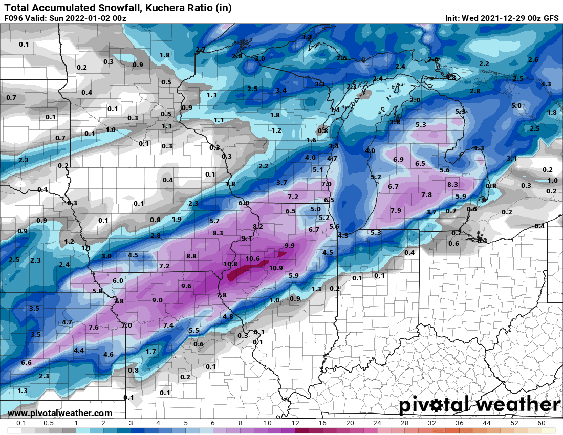
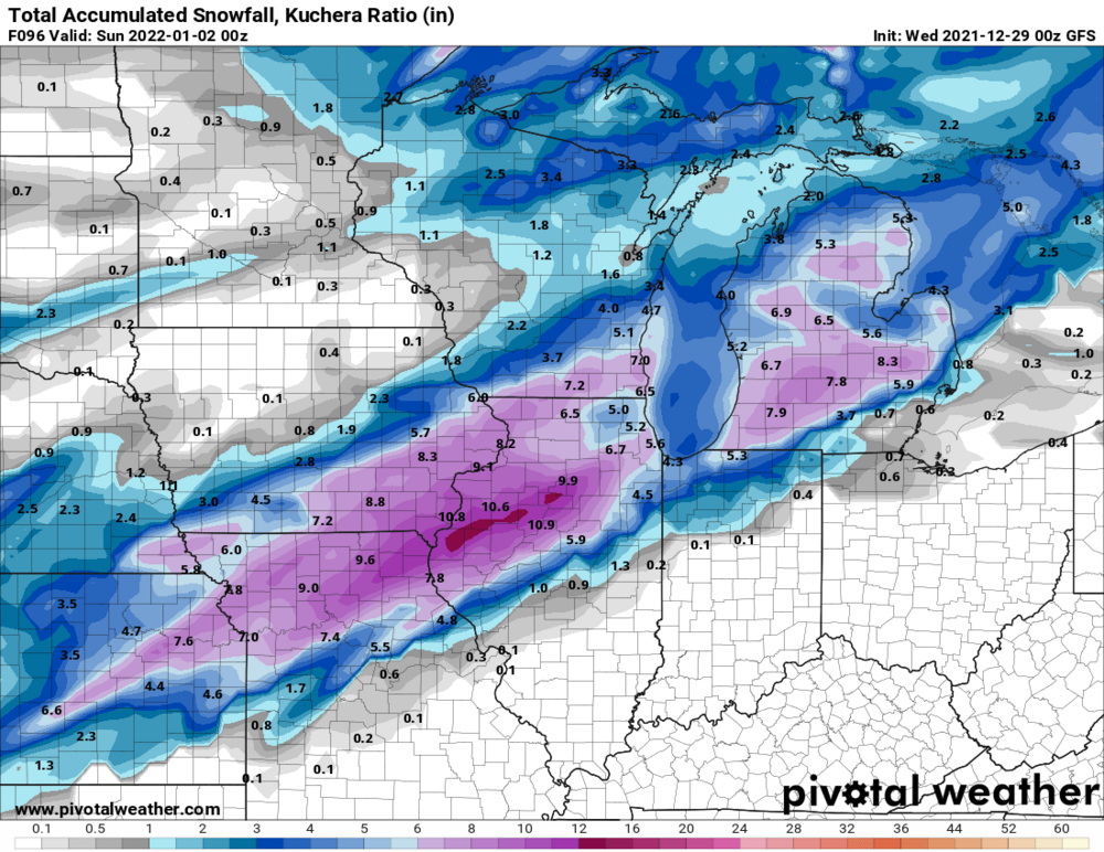
0z GFS
-
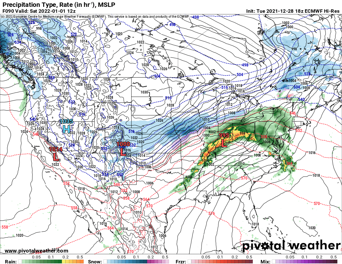
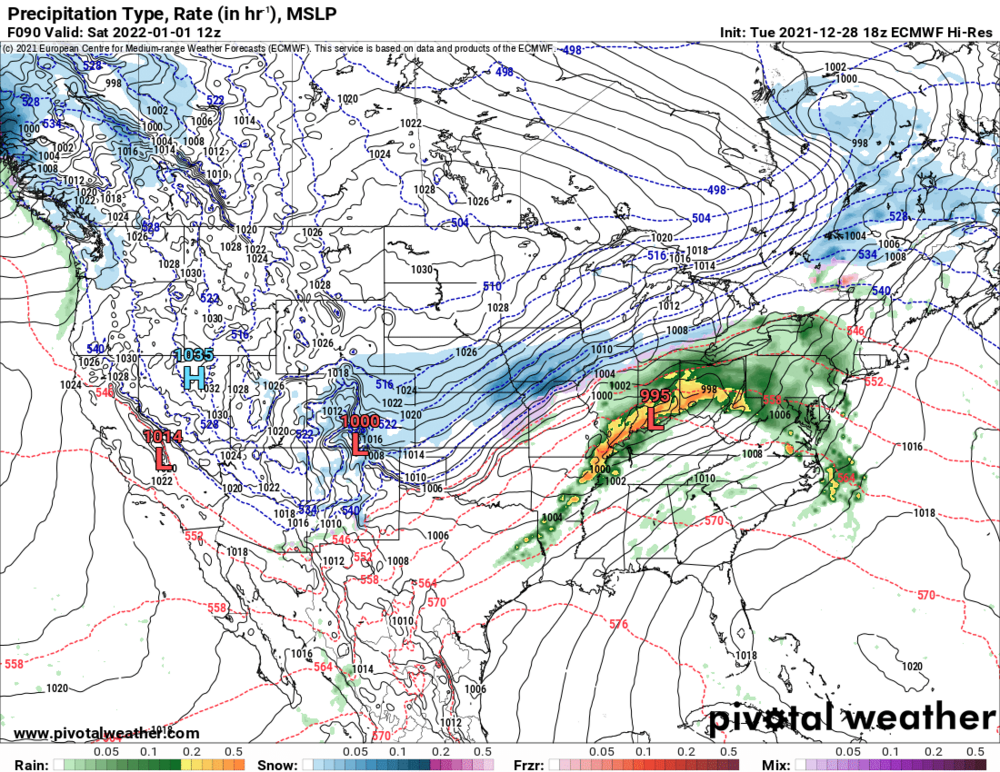
18z Euro 90 hours some big changes
-
Nice closeup
-
fantasy 18z 84hr NAM
-
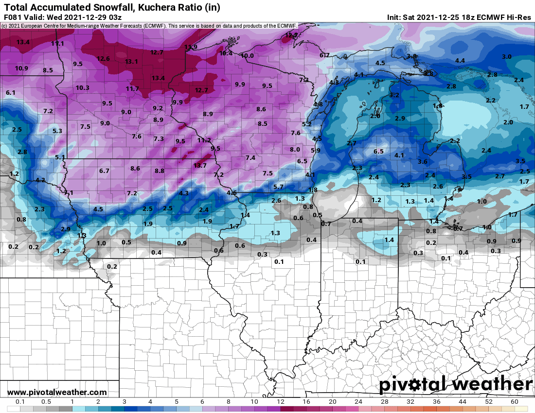
12z Euro 24 hour storm totals
-
URGENT - WINTER WEATHER MESSAGE National Weather Service Chicago IL 203 PM CST Mon Dec 27 2021 ILZ003>006-008-010>013-103-104-280415- /O.NEW.KLOT.WW.Y.0013.211228T1500Z-211229T0000Z/ Winnebago-Boone-McHenry-Lake IL-Ogle-Lee-De Kalb-Kane-DuPage- Northern Cook-Central Cook- Including the cities of Rockford, Belvidere, Crystal Lake, Algonquin, McHenry, Woodstock, Waukegan, Buffalo Grove, Mundelein, Gurnee, Rochelle, Oregon, Byron, Dixon, DeKalb, Sycamore, Aurora, Elgin, Naperville, Wheaton, Downers Grove, Lombard, Carol Stream, Evanston, Des Plaines, Schaumburg, Palatine, Northbrook, Chicago, Cicero, Oak Lawn, Oak Park, and La Grange 203 PM CST Mon Dec 27 2021 ...WINTER WEATHER ADVISORY IN EFFECT FROM 9 AM TO 6 PM CST TUESDAY... * WHAT...Slippery travel conditions due to steady snow expected. * WHERE...Portions of north central and northeast Illinois. * WHEN...From 9 AM to 6 PM CST Tuesday. * IMPACTS...Plan on slippery road conditions. * ADDITIONAL DETAILS...The peak snow rates of up to one half inch per hour are expected between noon and 3 pm CST. Snow totals are expected to range from 1 to 3 inches by the time snow ends.
-
KLOT AVIATION... For the 18Z TAFs... Upper-level clouds will thicken toward daybreak Tuesday as a storm system approaches from the southwest. Precipitation will arrive at the terminals between 17 and 18Z and continue through 21 to 22Z. Confidence is increasing that the predominant precipitation type may end up as steady snow, especially at RFD/DPA/ORD/MDW, with steady temperatures prevailing near the freezing mark. After collaboration with CWSU ZAU, the outgoing TAF package will feature TEMPO groups for visibility and ceiling drops to 3/4SM and 300 feet, respectively, at ORD and MDW between 18-21Z. Should snow end up steady enough, visibility may actually drop as low as 1/2SM. Elsewhere, targeted TEMPO groups may be introduced with the 00Z TAF package. After 21Z, the snow is expected to transition to light rain showers or drizzle as temperatures warm above freezing, though ceilings should remain at or below 500 feet. Winds are expected to be out of the southeast through the precipitation event. Confidence is medium in the forecast for precipitation type and associated reduced visibilities and ceilings. Borchardt
-
12z NAM is liking Hoosier
-
Winter 2021-22 Short/Medium Range Discussion
ILSNOW replied to Chicago Storm's topic in Lakes/Ohio Valley
18z Euro still has Tuesday N IL "snowstorm" -
Winter 2021-22 Short/Medium Range Discussion
ILSNOW replied to Chicago Storm's topic in Lakes/Ohio Valley
Great Izzi writeup (excerpts) Textbook La Nina pattern in place across the country and likely to continue through the long term period with a powerhouse jet stream, progged at times to exceed 200kt at 250 mb, separating record breaking cold over the Pacific Northwest and southwestern Canada from record heat over the southeastern U.S. Over the past week or so long and then medium range models have been advertising a gradual southward shift of the jet stream and storm track, placing our area under the gun for more active, and potentially wintry weather, during the long term period. The timing differences among the various models have shrunk considerably with precip expected to move into southern CWA shortly after 12z Tuesday and then spread quickly north, likely reaching the IL/WI border by around 18z. Unfortunately there remain meaningful differences in thermal profiles Tuesday, with the GEM and NAM both on the warm end of the spectrum and the ECMWF on the cold end with the GFS sandwiched between. In the GEM/NAM scenario, a brief period of wintry mix would quickly change to all rain with little or no accumulation. The ECMWF holds onto a deeper cold air mass longer and allows for a period of accumulating snow Tuesday roughly north of I-80 with the most significant accums north of I-90. Conceptually, a weakening/filling surface low would be less effective in dislodging low level cold air, which would lend a bit of credence to the EMCWF solution suggesting a quick couple inches of snow will accumulate, mainly northwest of I-90 Tuesday. The hyper active, La Nina fueled Pacific jet is progged by medium range guidance, which is in remarkably good agreement at this distance, to develop a classic Panhandle to lower Great Lakes strong storm late Friday into Saturday. If this system materializes as advertised, it would have the potential to produce a significant winter storm with heavy snow and strong winds Friday night into Saturday somewhere in the Midwest. Our area is certainly in the "cone of uncertainty" with this system and it will bear close watching over coming days. It`s worth noting that at this time range it isn`t the slightest bit uncommon for there to be dramatic changes in model guidance in both the track and strength of a potential storm systems, so it is way too early to place any stock in any particular model`s current forecast track or intensity, let alone their snowfall output. The primary message this distance is: stay tuned, it could get messy next weekend somewhere in the region. -
Watching the bears play Seattle in the snow when we have had none is unbelievable
-
Winter 2021-22 Short/Medium Range Discussion
ILSNOW replied to Chicago Storm's topic in Lakes/Ohio Valley
Excellent point in fact the 12z GFS still has the storm but it has a gone from a snowstorm (0z) to a rainmaker 12z. But good thing is a still has a decent storm in that time frame giving us something to track at least for now. -
18z Euro for Tuesday snowstorm

-
Winter 2021-22 Short/Medium Range Discussion
ILSNOW replied to Chicago Storm's topic in Lakes/Ohio Valley
12Z Euro with a full fledged snowstorm in N IL!!! -
Winter 2021-22 Short/Medium Range Discussion
ILSNOW replied to Chicago Storm's topic in Lakes/Ohio Valley
I get what your saying and would love for it to be correct but this is yesterdays 12z GFS. Cyclone lost 20 inches in 24 hours. -
Looking forward to our 2 weeks of winter in late January
-
18z GFS bringing the goods for saturday!!!!
-
Winter 2021-22 Short/Medium Range Discussion
ILSNOW replied to Chicago Storm's topic in Lakes/Ohio Valley
Christmas Eve 240 hr Euro -
12z Euro to the rescue
-
Just saw 3 flakes so well on the way to meeting seasonal averages!!!
-
January is gonna rock
-
awesome hit for cyclone!!!! Only 11 GFS days away!!!!!
-
KLOT update UPDATE... 1157 AM CDT Showers and thunderstorms have begun to expand in coverage across wester central into north-central Illinois. In collaboration with DVN, we have expanded the Flash Flood Watch to the remaining forecast area. Latest radar mosaic shows the corridor of developing activity to be better focused toward the western sections of the area. Morning DVN and ILX soundings show precipitable water values of greater than 1.8 inches with latest RAP analysis shifting this a bit westward. While far northern and northwestern areas have seen less rainfall in recent days, the efficient precip production and potential for multiple rounds of showers and storms thought that expanding the watch was prudent. Do not think that the threat has changed much for the original watch area as high water already exists and showers and thunderstorms are beginning to develop. MDB
-
Getting pounded last 1/2 hour here in buffalo grove and have the neighbors kids swimming in a newly created lake in my backyard
-