

PivotPoint
-
Posts
714 -
Joined
-
Last visited
Content Type
Profiles
Blogs
Forums
American Weather
Media Demo
Store
Gallery
Posts posted by PivotPoint
-
-
1 minute ago, LeesburgWx said:
Pummeled westernFFX/Loudoun County westward. Sign me up
Pummeled a strong word for FFX in that image. We should save that for actually pummelings, yes
-
 1
1
-
-
DC will prob be all but out of the snow by 6z tomorrow. Is what it is. Hopefully points NW can score
-
The only times I have found the nam useful at range is to confirm trends 1-2 runs after the Global’s spin them. Nam 48+ is not a great mode and pinning down main features like the Globals are. Now I have seen the nam not follow a trend for 2-3 runs in a row after globals suggested it. And nam has turned out to be right here and there last I remember was 2017 but can’t recall the event.
Anyhow, nam has played its part perfectly. It’s confirming globals. Just as always, is one to two sets behind.
-
 1
1
-
-
29 minutes ago, Ellinwood said:
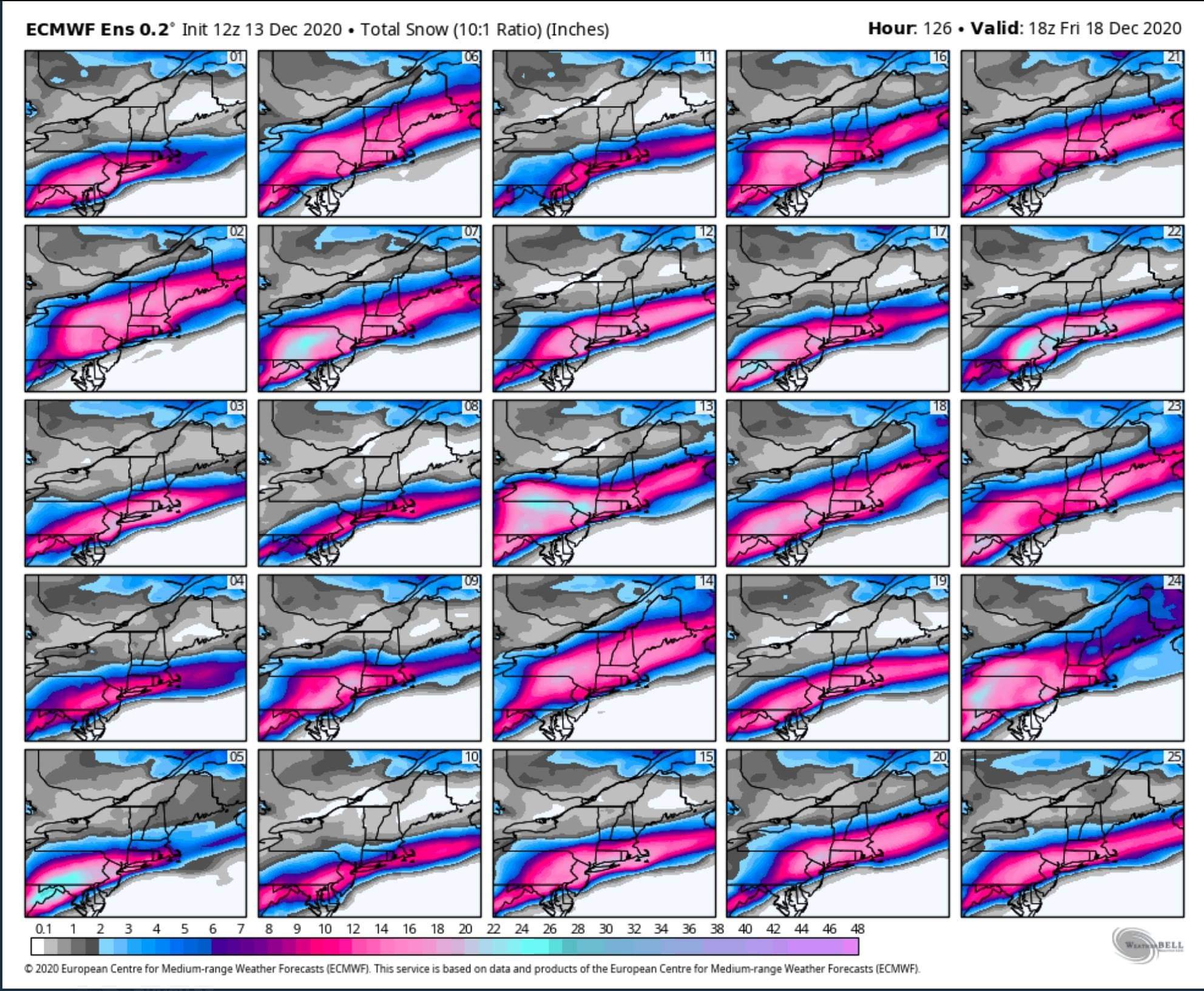
Updated my snow map... cut down on the total on the eastern gradient (mainly DC up I-95 and through southern and central NJ). Increased totals along the Appalachians.
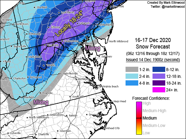
Pretty good imo. One exception is I think it's a little light for Leesburg, Middleburg, etc. That zone I still think verifies 10-12". DC is probably accurate, unfortunately.
-
1 minute ago, wxtrix said:
i got 32” in 2016 without any deformation banding. you just need rates.
Negative. The whole storm was a deform band at one point lol
-
1
-
-
1 minute ago, eyewall said:
After living in VT for a few years I need my fix LOL.
Good to see you on here. I use to creep all the time in the Northern NE Winter thread. Always enjoyed reading your stuff. My avatar pic is side-country at Stowe. Sad that I'm not allowed to up to VT this year.
-
6 minutes ago, NorthArlington101 said:

Doesn't look like we get CCB'd down this way but any shift at all (like 10-20 miles even) SE with LP track and things get exponentially better fo 95.
-
1
-
-
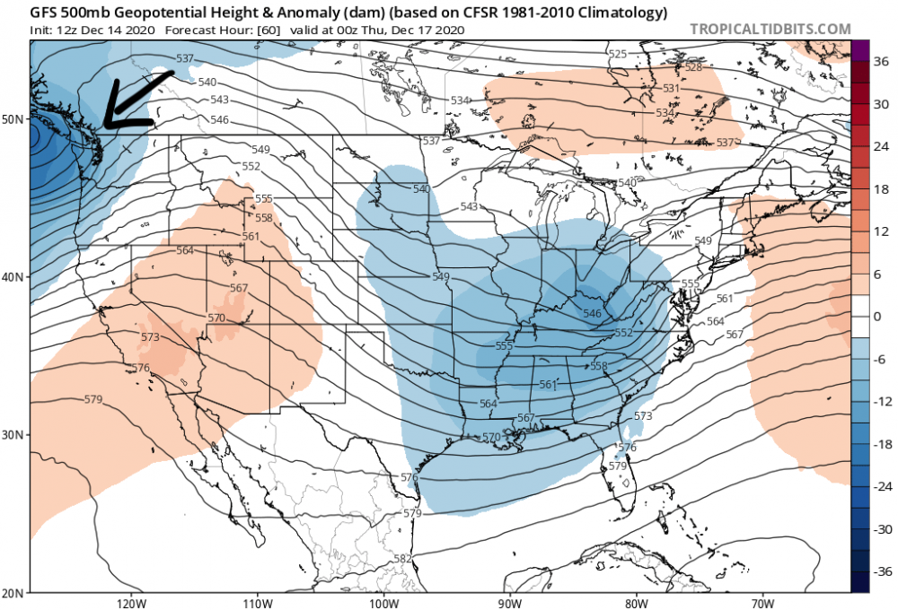
On 12/13/2020 at 11:44 AM, nj2va said:
Are we sure this is a Nina?

Funny you say that... Think DT was looking into the possible flip in the ENSO state that might happen during winter. Basically flipping from low Nina to neutral. Perhaps if that is taking place and we finally get some cyclical blocking periods this winter... We can actually have a winter that has threats throughout. Not just one period of 2-3 weeks, which stinks.
11 hours ago, poolz1 said:Cherrypicked....
This pattern doesnt look to go anywhere soon...and maybe improve to include some real cold to work with. -EPO joins the party.
Stable looking pattern.

Great to see AO continue to prog negative. EPO joining the party will help with our ridging out west.
-
Looking at some more specifics... I see one of the issues for us is the west coast ridge is getting squeezed by the incoming coast storm in Washington st/BC. It's hurting us because it adds a "pusher" up stream which affects us down stream and doesn't allow for our storm to have early development and close that H5 off like a 100 miles earlier. If that storm out west could slow down significantly or come in at a higher latitude, it bodes better for us imo with earlier development.
-
2 minutes ago, psuhoffman said:
The GFS is by far the lowest. It will adjust. Every other model has a qpf max of 2”+. There will be 20” totals from this storm it just won’t be over us. The Max is likely up in PA. That’s our problem...not qpf.
1 minute ago, clskinsfan said:CMC is wetter than the GFS. 1.3 out here for the event. A foot is still on the table for the 81 corridor.
I agree. I feel like QPF will not be a factor this go around. Still see the 1.5"+ up and down shen valley.
My wag is that the lp placement is too tucked with some of these latest runs. The speed of the system seems to be increasing each model run. I think best case for dc -- 20 miles west, will be the low placement staying a little further east and cold air hanging as long as possible. My initial call from 4 days ago still stands 2-6 dc area, Leesburg 6-12, Winchester to the mountains 12+. Hard to beat climo around here.
-
10 minutes ago, yoda said:
CCB is noice on the 00z CMC at 72... mauling everyone I95 and west
What are you talking about. A) not a mauling for most the sub forum, b) cuts total from previous run significantly. Honestly, close to banter man
-
1
-
-
Just now, clskinsfan said:
I am just stating what the model says. And even if DCA got 10 inches they would report 3
")
Unfortunately, there’s some issue with layers and surface 33-35 you can all but cut that in half, if not more. Not a great run. Loss the robust ccb look it was advertising but we all knew that was overdone. Key is that general track and synoptics hold course.
It’s been said but HUGE euro run tonight, lol
-
1
-
 1
1
-
-
25 minutes ago, mappy said:
My apologies! The emoticon of rolling eyes must have meant something different, sorry to interpret that incorrectly.
That’s my b. I thought I selected smiley face. Internet mishap

-
2 minutes ago, CAPE said:
Ok, just this one time..

HOLY GEFS.
There are some bigggg hits in there. P25 and I’ll never be snarky to mappy ever again. Pinky swear
-
3
-
-
Watching the eagles game so focus is elsewhere. But SOLID gfs run. Hoping this holds! Gfs has been pretty steady along with the euro. Not trending badly at the moment
-
45 minutes ago, mappy said:
And here I was thinking you and I had made some progress and had a level of respectfulness to each other, but I guess not. Anyway, you’re welcome.
I was kidding with you a bit too! Hence the smiley face. Truthfully. I like you Mappy. You’re cool
-
1 hour ago, mappy said:
Many have asked about Bob Chill. We don’t know. He hasn’t showed since March. I think it’s best we stop asking, he will pop up when he wants to, and we all hope he is well. Let’s try to keep the thread on the threat
Yea if you re-read I didn’t actually ask where he is. Just said I hadn’t heard. But yea the other two responses are on the thread. Thanks for updating with the non-update

-
41 minutes ago, jaydreb said:
No, please keep analyzing the DC metro area. Thanks.
@psuhoffman is vital to this community and should have free reign to dissect, interpret, inpart his knowledge. I’ve learn like 70% of what I know by reading his stuff over past 6-7 years. The remainder is made up of @Bob Chill which I still haven’t gotten a whereabouts for him. Hope he’s ok. He’s awesome too.
36 minutes ago, AmericanWxFreak said:
Basically only difference between gfs ens and ec ens is like 30-40 miles more south for gfs. Actually pretty impressive models are that close multiple days out. Shows how far weather modeling has come.
13 minutes ago, AmericanWxFreak said:
Process of elimination. The dc hits are disappearing. Becoming clearer for dc proper, unfortunately
-
 1
1
-
-
1 minute ago, CAPE said:
Yes I know, thus why I got "turned on" and posted it. lol.
Oh lol. My bad... I was “excited” too. Pants party
-
14 minutes ago, CAPE said:
Who cares what the wonky surface maps look like. This looks interesting.

That’s a banding signature.
eta: ninjad
-
1 hour ago, Baltimorewx said:
I think it’s pretty clear that 95 and metro areas will struggle with mixing and snow accumulating until about 00z, but it also looks clear that we all get destroyed by the CCB all the way to the bay. So 02z or so until about 8z should be pretty damn fun.
I’m always untrusting I’d wrap around ccb. Feel like this is very easy for models to over do at range. We would need to explain why this either a) slows down and deepens quickly, or why ccb looks so good on just gfs. I wouldnt trust wrap around unless I see some meals closer to game time.
-
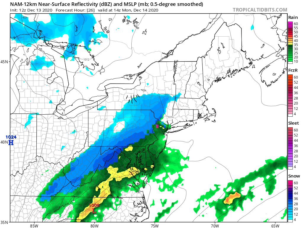
Nam liking the monday deal a bit more

-
4 minutes ago, MN Transplant said:
You don't want the purple line anywhere! You want the best upward motion (the black areas) in between the -12 and -18 contours as much as possible.
Oh lol, I thought the purple was -12 and the red -18. Haha, just looked purple is zero! Yea, I see now... I was so confused why it looked like a decent vertical field for upward motion between the two temp layers. But the bottom layer is actually zero degrees. Thanks
-
1 minute ago, MN Transplant said:
Nice visualization from CoolWx for the GFS. You have Omega (effectively upward motion), -12 and -18 °C contours to highlight the dendritic region, and the freezing line.
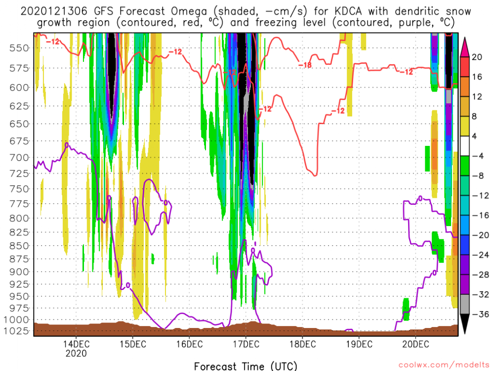
Hey MN-
Ideally, you want the purple and red line on this frame to be 850 to like 725, respectively, for optimal dendrite growth?


December 16/17 Winter Event
in Mid Atlantic
Posted
Stinks because there is decent slug of cold air to the nw. If this had developed a little more we could of tapped that. The progressive nature though is not going to allow for heights to crash after the deluge of low level warm air advection.
So close