

PivotPoint
-
Posts
714 -
Joined
-
Last visited
Content Type
Profiles
Blogs
Forums
American Weather
Media Demo
Store
Gallery
Posts posted by PivotPoint
-
-
Just now, mappy said:
lol buzz off

“Do as I say, not as I do.” Yes?
What do you think of my early totals call? I have you in the 6-12” range for Wed’s storm
-
52 minutes ago, mappy said:
That is does! 11 years next week, and my kid turns 8 the week after that. Goes by too fast.
Keep the banter down guys.. we got a storm we’re tracking here!!
-
 1
1
-
-
25 minutes ago, Eskimo Joe said:
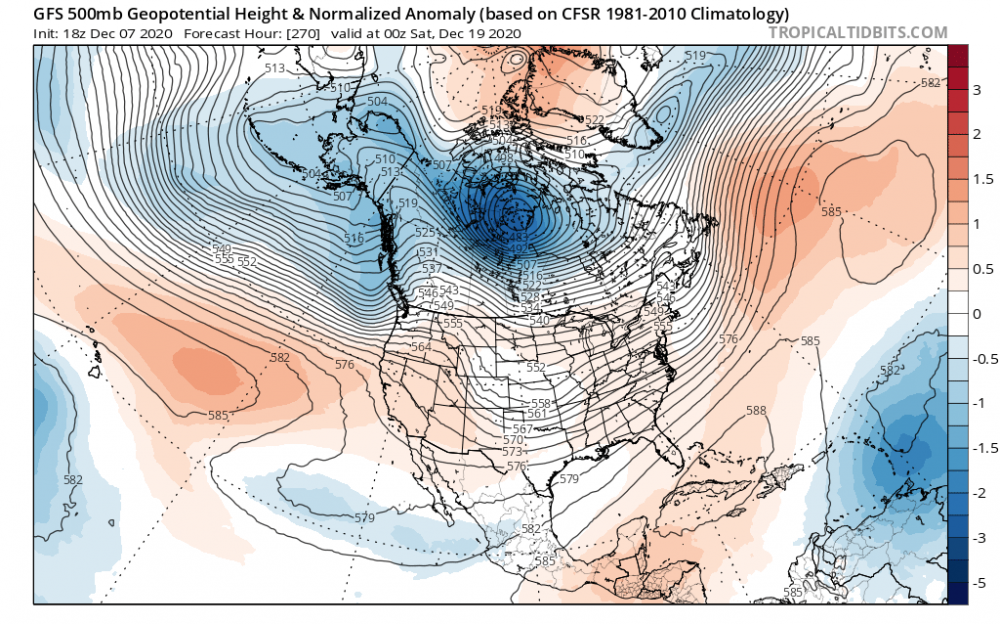
So far, the 12z Euro looks better for the 12/16 event at 500mb. Better confluence, and western ridge.
4/5 days ago when the pattern started to advertise itself I mentioned the PNA and ridging probably being the greatest key to this setup.
We have a stout high in the correct spot but the airmass is still marginal given it’s early in the season. We need to amplification and a ridge out west that flattens or breakdown as our sw amps up will not produce for the cities. I still see this as a mix event at best for the most of dc metro and immediate suburbs.
Winchester on west to Canaan Valley should do real nice. If the ridge axis and heights out west stay the course. Perfect ridge placement and I think the rest of the ingredients will be there in some form or another.
Early call for weds storm is 2-6” with mix cutting totals and some melting around the city and Nova, 6-12” Winchester through Frederick MD, Baltimore 4-8”, then jacks of 12”+ at elevation Canaan and eastern part of laurel mountains. Central PA jacks as well as parts of jersey.
-
2 hours ago, Snowchaser said:
I agree. It will be hard for snow in Virginia on Monday. But West Virginia near Snowshoe could see a nice snow event
Yea, it looks pretty good for a pasting. They do well when layers look marginal elsewhere.
28 minutes ago, LP08 said:
Icon always has issues with precip shield modeling. In reality, the wave is too progressive at h5 and doesn’t support that type of expansive shield to the NW. I call bs
-
 1
1
-
-
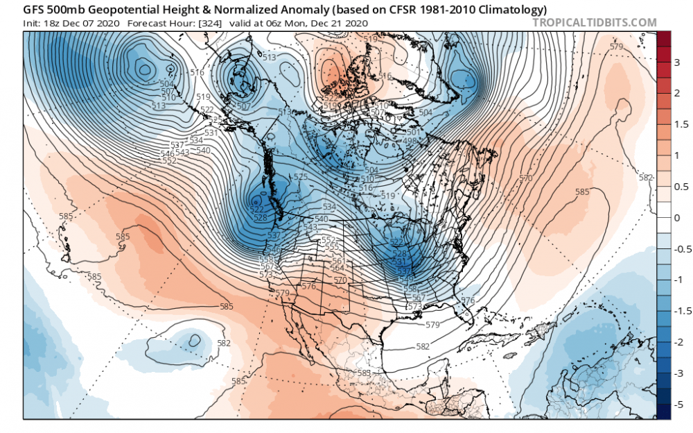
1 hour ago, SnowLover22 said:
GFS D12 is interesting. All caveats apply of course but this is a nice H5 setup.

This is the time frame I mentioned couple days ago. It’s interesting to me because of the storm prior to this (15/17th) seems to consistently be there run-to-run. Making for some blocking. However, the ridge out west is all over the place each model run and is super key to this recipe coming together.
I think the odds are That the ridge out west flattens out and this cuts. But there’s a chance if we can get inside the weekend and it’s still in some form on the models.
-
6 minutes ago, psuhoffman said:
1955/56 and 2011/12 are the two best examples of somewhat healthy nina's that collapsed rapidly to weak status during winter. 2011/12 was a little weaker of a peak and 1956 made it into strong nina category. 2011/12 it did us absolutely no good. 1956 we did turn cold and snowier in the mid atlantic region in March. Of course there are other variables you have to control for and a sample size of 2 is kinda small to draw conclusions.
Thanks. Either way my moving out of La Niña is the way to go.. but yea, small sample size
-
Nina talk aside..
I like how multiple runs I see the PV building strength then being disrupted. If you look around the 18th, the gfs has strengthen PV and WAR. The WAR isn’t in the most ideal spot but if you pan forward to the 20/21st, the PV sends a lobe of cold air diving SE. We seem to be losing our ridging our west (stupid AK vortex needs take a vacation).
I like the look because the WAR does some blocking while cold air builds in central Canada. If we can get a positive/neutral PNA, I think the timing of a cutter could allow for downstream timing to work in our favor... assuming there’s even a s/w there to do anything...
-
1
-
-
56 minutes ago, DTWXRISK said:
.. we are NOT in strong La Nina.
WE have NOT been in a strong La Nina
and we will NOT be in a strong La Nina and all of the model data shows rapidd weakening of the La Nina by early Jan
it doesnt matter how many times you say it.. Its wrong
That’s what history of moderate to strong Nina’s say.Are there any decent analog years for weak Nina flipped to neutral/ weak nino?
Like, what’s our goal posts here?
-
6 hours ago, pasnownut said:
I can roll w/ this....would be nice to see some clippers. Snowbelts likely approve as well.

Yea, unfortunately that’s not even a great look for LES. Too dry. But at least the Atlantic isn’t awful. I always feel like we have ways to score (usually small) if at least there isn’t a big WAR.
-
1
-
-
3 hours ago, psuhoffman said:
The EPS still shows a brief window around Dec 16-18 before the pac puke arrives if something can amplify before the cutter vacates the 50/50 region. After that looks ugly. Silver lining is the Atlantic side stays ok. Unlike last year there are hints, including signs of a SSW, that the NAM might not be a complete lost cause this year. The pac looks a mess. I kind of assumed that was coming. But last year the Atlantic side was hostile too. That’s a no hope situation. If we get some Atlantic side help this year we should get some opportunities. It will still be a struggle and a fight. Nothing will come easy. But it’s not hopeless like last year.
That’s the key and how we get lucky now and again. Spacing is close enough where a cutter turns 50/50 and allows the a s/w on it heels to drag the boundary far enough east that it locks some cold on tap.
Atlantic will need to ply nice so it still doesn’t run west of us, but not such a pushover that It doesn’t develop and slides OTS.
Atlantic can’t be any worst than last year. It was horrendous.
1 hour ago, psuhoffman said:It’s good news...but it doesn’t get back to weak Nina status until around Feb and there is typically a lag in atmospheric response so I’m not totally sure it will save us from a generally hostile pacific pattern during the “meat” of winter. I am optimistic at signs (including the SSW) that we might get more help up top and on the Atlantic side that could offset a less ideal pac pattern at times. Last year EVERYTHING was wrong. And not saying the weakening Nina isn’t a good though. Every bit helps.
I tend to agree with the lag on these big seasonal drivers. But DT is right on the mid Atlantic goal posts — it’s really not till very end of Dec through mid March. WW has pushed itself closer to start of spring over the last 20 years in NOVA and I don’t know how to explain why , but anecdotally, I feel like it has.
1 hour ago, DTWXRISK said:FWIW I consider March to be part of winter
if you take a look at recent Trends over the past 20 or 25 years you will have noticed that the month of December has really become an extension of November for the eastern half of the CONUS. By that we mean that for the most part they have not been a lot of significant cold air outbreaks or big snow storms especially before Christmas. On the other hand over the past 20-25 years the month of March has seen very little early spring weather in the eastern half of the country. There have been quite a few number of significant snow storms ice storms and below normal temperaturesTotally agree with this
1 hour ago, DTWXRISK said:CAPE .. the Big Alaskan Upper Trough / Low is in part associated with Mod / strong La Nina
in 2nd half of the winter as La Nina weakens that feature will go bub bye ... and IF .IF... Atlantic side holds
we may be in businessIf that happens... I see signs of a flexing and waining PNA for us this year, which is a good thing. Do not see that tele as dominant feature either way.
As PSU mentioned, Atlantic looks more neutral driver than the killer it’s been (really past two winters). If Nina weakens as we move through Jan then west pac riding becomes more likely and we might score.
-
23 hours ago, LP08 said:
There is definitely a window between say the 13-18 of a pretty decent pattern available. After the cutter next week, there will be some fresh cold air to tap.

AK trough rotates down and squashes our +PNA. It’s also a 240+hour frame so I personally wouldn’t bank on this general idea
23 hours ago, CAPE said:Per the GEFS and GEPS, finally some below normal air in northern/central Canada mid to late month. Lets hope the trough over AK doesn't park there and deepen, and scour it all back out. Then we just need a mechanism to bring it southward.
Bermuda high is creepy back in a little more each GFS run. We’d need a stout HL block to prevent cutters each time the PNA relaxes.
I actually think the look for D5+ is marginal and trending worse, unfortunately.
What would be better is if the one eyed monster would vacate and the Atlantic cooperates. Then we can see sliders, clippers and maybe even an Mill-A
-
Deleted and hiding is semantics. If it’s not up there then it’s being suppressed.
Most be nice for you... hide, move posts at your discretion. Manipulate the narrative as you see fit. If you’re not in media you should think about it. You’d fit in perfectly.
-
1 minute ago, mappy said:
Your post wasn’t deleted, and I moved it to banter for you. You’re welcome
Lie.
it was originally deleted and you just moved here cause I called you out.
Thats the truth. Own it
-
I love how posts disappear for calling mods Out for their own banter lol
It’s hilarious how sensitive the hall monitors are In here to their own critiques they so willfully hand out to others.
Deleted... not even moved to Banter!
If something is not offensive or doesn’t use bad language then it should not be completed deleted. That’s un-American in every sense of the idea.
The age of censorship... welcome my fellow Americans.eta: oh and @mappy since she is the by far and away the biggest banter accuser and simultaneous banter creator in the whole lot.
Its actually impressive the lack of self awareness (incoming response about my lack of self awareness... beat you to it)
-
 1
1
-
-
On 12/4/2020 at 9:54 AM, mappy said:
do you think you could cancel winter in the banter thread, or panic room? its incredibly tiresome to see it in every thread.
It’s called humor. Lighten up
On 12/4/2020 at 10:05 AM, mappy said:yup. stop canceling winter in every thread. do it in banter or the panic room. thanks.
Uh oh she’s getting mad...
On 12/4/2020 at 10:12 AM, mappy said:you better figure it out. i'm not asking you again.
Tea kettle starting to whistle
23 hours ago, mappy said:Banter
9 hours ago, DTWXRISK said:who ever said that about 18z euro was wrong sw va will do ok with this little event
We all live in NOVA. Virtually all
6 hours ago, psuhoffman said:You’re not wrong from the perspective you are analyzing this. But the majority of the people in this thread are in the Baltimore/DC area and so to them it’s looking like a fail.
Bingo
-
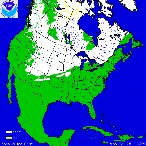
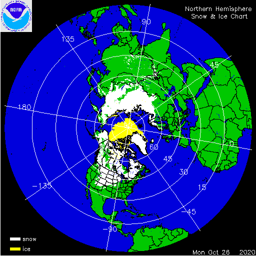
Not a bad looking coverage map for oct 26th
Maybe our La Niña winter will buck the trend.
October Siberian snow coverage doesn’t look all that robust though. Ehh
-
BWI: 10/27
IAD: 10/27
DCA: 11/14
RIC: 11/13
TB: Warmest October Temperature: 81F
-
10 hours ago, showmethesnow said:
Overnight GEFS pretty much showed what we don't want to see as we move into our possible favorable period. Below are the run over run changes that we saw and you can see that it became aggressive with dumping energy into the SW. Thus we see the response of the ridging going to town in the east.
Now for comparison sake here was the previous run. Here we see a split flow in the West (circle) creating basically a northern +PNA over-cutting a weakness (trough) in the SW. That's a good look for possibilities in the east. As you can see the SS dips in the west and we see it creating ridging to its east. But this ridging is muted and shifted to the west (good look for possibly pumping southern moisture into any developing system). The differences we are seeing with that ridging can be attributed to what we see with the NS. The NS in the below example is for the most part bypassing the SW weakness and moving eastward (follow the flow lines) creating push back to any ridging as it carves out the trough in the East. Now if you compare that to the above example we are seeing the NS (follow the flow lines) is more aggressive with the SW dump creating a full latitude trough. In response we are seeing full latitude ridging in the east.
Now the first look just isn't a winning looking. It just isn't. Sure we could always luck into something. But it would be highly doubtful. Now we really need to see the NS for the most part bypass the SW. Otherwise we would be highly dependent on seeing very strong blocking up top to counter and push back against the desire for the pattern to pump up strong heights/ridging in the east.
Now the models have been teasing back and forth with what they want to do as far as dumping energy in the SW. This just happened to be a run that went to the Dark Side. Who's to say that it won't flip right back come the 06Z run. So at this point I am not overly concerned. But if we start seeing this dump run after run on the various models....
I love the thoughts (and arrows) but it ain’t gonna progress that way brotha. Submit to the snowless winter of 19-20’
9 hours ago, C.A.P.E. said:Remember the PNA ridge? I pointed this out the other day on both the GEFS and GEPS- although they both were attempting to build a +PNA on the means, the tendency for h5 heights to quickly build back further west was also notable. Well, look at the latest runs. This should hardly come as a shock lol. I am not a believer in the HL region becoming favorable and mitigating the crappy Pacific. The +AO/NAO has been very stable, and although it may relax a bit, not sure it will be enough to make a meaningful difference. The most notable ridging "up top" on the GEFS in the LR is over central Canada/Hudson Bay. Been there this winter.
Yea, too many stable features that models want to breakdown and end of runs. Never happens. Still surprised anyone I even trying to forecast beyond 4-5 days this year
6 hours ago, Weather Will said:0z EPS finally came out on WB. Nothing to report through the end of February....only hope appears to be that the EPO will go neutral to negative by the end of the month to give us a chance in March until Spring arrives. My expectations are low. There are the 10 percent chances here and there before the end of the month but unless I see the probs. going over 50% for a time period under 10 days , no more prob. maps from me. (I hear the alleluia chorus).

This.
It’s the truth. Nothing to report and it will be that way. It’s not negative. It’s weather
6 hours ago, showmethesnow said:Most on here realize the futility we have gone through this year. We get it. So why state the obvious (being failure) on something posted that actually has somewhat of a positive spin? All this negativity gets old, hell it has been old for several years now. Just saying.
Eta: you know, if you would have just added a reason to why the map was bs, any reasonable reason, then I would have been fine with it. But seeing as you didn't it becomes nothing more then just another post of the multitude we see these days that add no value except to add to the clutter and perpetuate the misery we see in here.
You’re always the optimist. And the pessimists are the pessimists. We need both to have a good vibe. And with winter weather as poopy as it has been this year we need the fatalism for a little levity in the thread
5 hours ago, psuhoffman said:I think some are managing emotions. They would rather not expect anything and resign themselves to crap then get their hopes up to repeatedly be let down. Thing is they don’t need others agreement to manage their own emotions.
As for me I’m just a realist. I’ve tried to mix in some positive spins at times but there really hasn’t ever been anything more than Hail Mary type long shots all year. While there were some snows in a +AO regime none featured this pac look. On top of that none featured the +4 stdv type AO we’ve been dealing with. A quick glance at the h5 loop everyday is all it takes to quickly ascertain how hopeless it’s been most of the time.
It’s emotional. But more so, the optimists are still grasping at straws. It’s over man. It’s just over. With a super positive AO and reloading WPAC ridging here and there, it’s almost March. It’s fun to analyze but this winter is not really winter lol
2 hours ago, Deer Whisperer said:I’ll go with p01 to verify
That is 100% correct
2 hours ago, psuhoffman said:GEFS did not trend the way we want for the day 8 super long shot but it does do what I said I wanted to see in the long range. Followed the progression I highlighted on the EPS earlier.
We need to get that ridge centered back in central Canada or west of Hudson Bay would be ideal...

GEFS strongly indicates the cutter idea day 11-12 but then sets up a look we can work with at the end.

Being that far out there is obviously disagreement on exactly where the waves will be and that is why we see that huge spread out trough...but the key features are the ridge centered west of Hudson Bay in Canada and the strong indications of a 50/50 type feature to our northeast. Then we just need to see how the timing works out with whatever waves eject out of the west in that look.
Again...assuming the look is real...but another run with that look so I guess odds continue to increase that MAYBE this isnt a mirage if we keep seeing it move closer in time.
Huge surprise
2 hours ago, stormtracker said:Man, without that caution, I would have gotten excited and expected a foot of snow for sure.
Lol
1 hour ago, psuhoffman said:GEPS was a nice run. Caved to the idea of a Canada ridge and cutting a trough under into the east. It’s likelt transient and it’s reloading the super + AO at the end but it would create a good window first. This temp profile works in early March.

I am trying to be positive and at this point I’m just hunting for a look that could produce one storm. That’s all.
So far the possibility of a workable look to start March hasn’t collapsed....yet
It’s 384 man. Step back from the ledge!!
1 hour ago, psuhoffman said:What do you want me to do about the fact the next 10 days (at least) we are still stuck in the same crap pattern? Pattern change has to come first. Then maybe we get an event. Whether that is 5/10/15 days away you can’t force a threat where there isn’t one. If you keep latching on to every lottery ticket level prayer from day 8 in this awful pattern you will continue to be let down and frustrated. Maybe something does hit on one of these crazy long shot setups that require 15 moving parts to all go our way but I bet if it does it will be something not resolved until short range and it pops up closer in. We are not getting some long range trackable event in this pattern.
Y’all should do what I’ve done since mid January:
Mt baker
Jackson Hole
Stowe Vt
Currently Innsbruck, Austria as I type
Go to the snow. It’s around just not in dc
-
1
-
1
-
 1
1
-
-
1 hour ago, Ji said:
to where? the north pole?
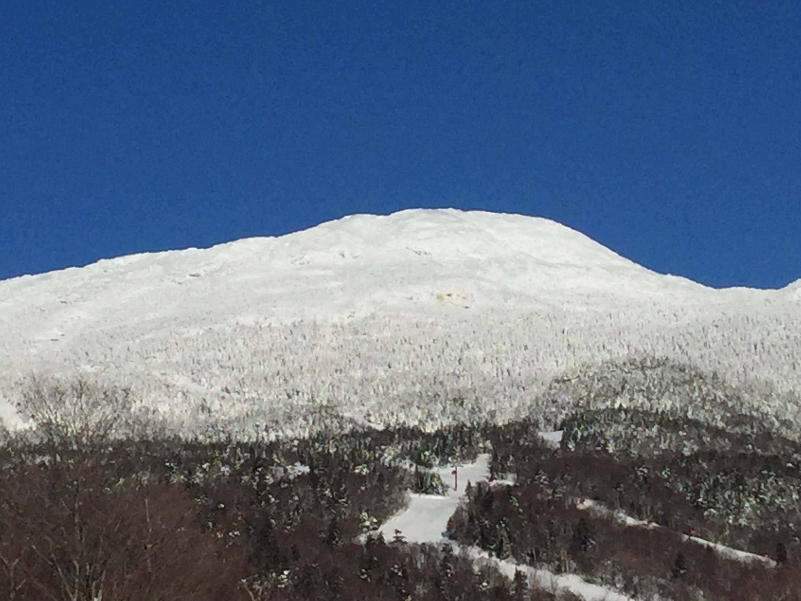
56 minutes ago, stormtracker said:Burlington, dude. They've been getting clocked with every west/app runner we've had.
I’m in Burlington since Friday morning. Skied Stowe today. Friday I bar hopped and watched 12” fall between 10am and 7pm. 22 degrees and cold smoke for 8+ hours. Skied 14” at the resort today.
If y’all love snow then become addicted to skiing (like me) and you’ll always have a good reason to travel.

-
1
-
-
4 minutes ago, powderfreak said:
So looking at the Snow Cam... 9am nothing... 1:30pm there's about an 8" stack.
8" in 4.5 hours and it really didn't get going until 11am to be honest.
We are checking the High Road stake manually in a bit to see if it confirms.


That’s so awesome and I believe it. I’m down in Burlington and it started in earnest around 9:30/10am. I checked at 12:30pm when I went for a walk and the spot I cleared in a minimally wind prone area had 4.4 inches. No doubt the mountain is cleaning up at a 30-40% higher rate.
-
7 minutes ago, J.Spin said:
Well remember, for the vast majority of people there, it simply means a 5 to 10-minute walk back to their dorm or apartment in town. Or, it just means not leaving their dorm or apartment at all for their afternoon class that’s been cancelled. For the small percentage of folks that live out of town it’s a huge hassle, but canceling classes (especially for the medical students who essentially have class all day, every day) is a big logistical issue. I definitely didn’t want to drive back and forth to the mountains in this though unless absolutely necessary, so my teaching assistants and I worked extra yesterday so we could cancel our midday meeting today. That was probably the best approach, but not everyone’s Friday schedule would have permitted that option.
That’s a well thought out approach
Is it me, or does the low seem to be a little ahead of schedule position wise? Looks a little faster, no?
-
It’s crushing in Burlington right now. Hope PF is getting the goods
-
Biggg dry slot in Northern Vt right now.
6z NAM had it. Hoping it fills in soon
-
Driving up 91. About 1.5 hours from Jay Peak. Getting light snow, no sleet. Returns overhead are moving in from NW? Thought there was a warm nose? Looks like a NW flow.. hmm


December Medium/Long Range Discussion
in Mid Atlantic
Posted
Fair enough fair enough