

PivotPoint
-
Posts
714 -
Joined
-
Last visited
Content Type
Profiles
Blogs
Forums
American Weather
Media Demo
Store
Gallery
Posts posted by PivotPoint
-
-
32 minutes ago, mreaves said:
I'd like to lock that now. Stop the presses on the other model runs. And I want it exactly as its shown here, none of that "It's the NAM cut back on the qpf by 1/3" BS. I want the whole enchilada 12" of snow fortified by some sleet and freezing rain.
I like where your head is at. Gotta get the next couple runs to pull her back south. Stop the mid level warm air push.
Make Big Snow Storms Great Again!
-
24 minutes ago, CoastalWx said:
Stop with those TT maps. That includes sleet and inflates those totals.
You’re right. I still think it shows trend wise that the big slug of qpf distribution is not still jogging north. Gotta stop the trend
-
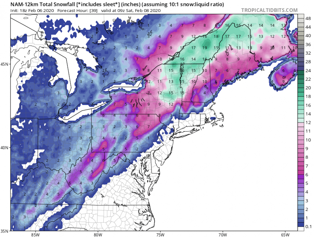
18z NAM holds serve. Maybe slight tick south with best qpf from prior run -
59 minutes ago, powderfreak said:
Tucky tucky. The HRRR tracks the low over SLK lol.

The trend will reverse slightly and jay and Stowe will be back in the 15+ range. Models do this a lot with wound up systems right as they develop. I bet the next couple of runs tic it back down another 50-75 miles. Track adjust slightly south
-
11 minutes ago, powderfreak said:
Up to 3-4” range... need to grab 8” tomorrow.
I forecasted 8-16” on here and 7-14” on FB so I think that’ll nail it.
Bush league to run with the heaviest guidance all the time
") .
.
The globals are almost in lock-step. GFS just ran and its easily 12+ Euro is 12+
Stowe-Jay peak is gonna get crushed tomorrow. Easily 15+ total. It's locked.
-
1 hour ago, moneypitmike said:
For you and a wide swath where no one else lives or cares about (except skiers).
")
The other 90% of the board are fully prepped for another round of meh.
I VERY much care.. and will be visiting the land of PF this weekend. Driving up from DC starting 6:30pm Thursday night after work. Thinking first wave is starting to clear out by then. Looking at timing, hoping to be past Boston by midnight-ish. Can’t tell exactly but looks like my biggest trouble will be once turning to snow Connecticut rt 91 heading into VT.
Dont hate.. par tic i PATE!! Everyone in the forum should come to Stowe. Screw work.
Go Euro- ukie combo
-
Just now, WinterWxLuvr said:
At some point something HAS to trend our way.
Warmth never has a problem trending

I do like this vort though. The little vort that could

-
PP storm gaining traction...
-
16 minutes ago, showmethesnow said:
Pretty much given up on that. Get a day of two of better looks/trends in that direction and yet inevitably it slides backwards. Has happened pretty much every time. Been one of the more frustrating winters in that regards because it wouldn't really take much in the way of shifting that PAC ridging eastward to get a somewhat half decent setup despite no N Atl help. Whatever. Think I am going to do what others have been discussing and travel to the snow. That is if I can get a decent storm to time up around the weekend in a local that is within 3-4 hours driving distance.
I’m a skier so I’ve been watching 40north and obviously they have a good chance at multiple events in he next two weeks. They actually do well with a neutral or slightly positive nao. We get screwed unfortunately. Checkout Burlington. It’s a cool spot. PF (powderfreak)in the New England forum works at Stowe and can give good recommendations on things to do if you don’t ski.
Our chances improve if we get a modest ridge to develop over Idaho and a neutral Atlantic. I’m done speculating though. I’ll believe it when we’re within 3-4 days
-
 1
1
-
-
34 minutes ago, stormtracker said:
It's still there! But we get the screw! Bidness as usual..carry on
Lol. I’m grasping at straws... I know

-
1 minute ago, Interstate said:
The ads feed off your browser history.
Well done Ji lol
-
5 hours ago, Ji said:
Sunday wave

That’s my wave. The PP storm

-
2 hours ago, showmethesnow said:
Be careful with that look on the diving NS. That was the look that reeled me in at range for the system we are currently seeing run through now. As you can see now the NS ended up being more progressive and dropping into the States farther east then originally projected.
eta: But I agree, I like the look as well if it can actually verify. Good drop placement and track to actually pop a good little event.
Yea, you’re right. And I don’t expect this to come to fruition. But I, like you, think the placement at 500mb looks like a great spot if something were to have enough space and strength to dig.
-
I’ve been watching this time frame for a little while. We get this pseudo ridging in the middle of the country right as a NS vort is rounding the base of the trough sliding east.
Ive seen these small clippers that redevelop before. They usually redevelop off the EC too late for us due to the ridge axis and progressive nature of our troughs, but sometimes they slow down enough if the trough can dig a little deeper and upstream flow is slowed down with 50/50 of exiting coastal (storm before the storm)
Something to keep an eye on for a 1-4” deal. Would sure brighten the mood

-
42 minutes ago, psuhoffman said:
I’m going to hit up either Utah or Aspen sometime before the season is over. I would prefer SLC, so many great options but might lean Aspen because flights to Denver are a lot cheaper and easier to get last minute.
Aspen is cool. Go a bunch myself. Two words: Apres Ski...
-
2 hours ago, Ralph Wiggum said:
You're debating 'textbook' look over what I posted which you stated wasnt a 'good' look. I agree it wasnt strong on the ens means but plenty of members had such a look and besides the GFS there were other ops that had similar looks. My point isnt to debate you on textbook epic vs good. More was pointing out how guidance essentially did a 180 on that map I posted. I'm sure you can at least agree with that no?
I agree. I don’t care it’s op at range the point is there were a few good runs that gave us a glimmer now it’s a desert waste land of bad runs. And it makes sense given pna, epo, ao, nao, etc. None of which are sided in our favor or progged to be at least in next 10 days
22 minutes ago, cbmclean said:Looking at the NAO, at first glance, the 2010s doesn't look too horrible. Definitely skewed positive from about 2013 on.
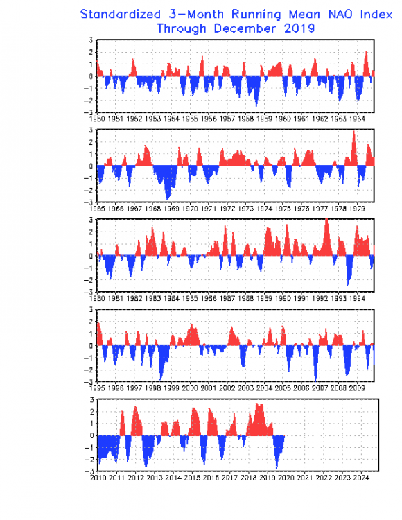
But its deceptive. Most of the blue is in late summer to fall. If you just look at Jan - March, a different and more familiar picture emerges.
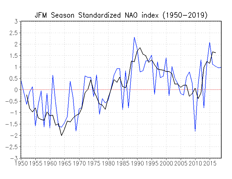
After the spectacular neg spike of 2010 it has been downwhill, or rather uphill, uninterrupted + since 2015.
That graph also clearly shows the state change from the 50s/60s/70s "good ole days" to a much more hostile environment since 1980. Something is clearly different. The big question for us, is it natural variability or you know what?
It’s definitely unnatural influence, at least to a degree. The degree being the question. But I will say that 24hr/365 days a year of pumping green house gasses by multiple industrialized nations... it doesn’t take more than 2nd grade logic to understand that this action cannot go on in perpetuity with ZERO consequences. Lol, I mean... come on.
The great debate (if there even is one any longer) ends with a simple truth... there is no “free lunch” that exists in our physical universe. If we want to pump co2 from sun up to sun down across the entire planet , the earth will eventually respond, in kind (of some form). End soap box (sorry)
-
 1
1
-
 2
2
-
-
1 hour ago, psuhoffman said:
It’s very rare to get under 20” here. Only happens about 10% of the time. But we’re due. Hasn’t happened since 2008 when there was only 19.2” here. 2009 barely got to 20”.
psu - what are you at on the season out of curiosity? I’m like .5
37 minutes ago, Bob Chill said:I barely looked at anything this fall because all signs pointed to a lame year. Then I got suckered into believing we had a chance with the big -AO in Nov and a decent start to Dec. Once the AO flipped +++ I had that sinking feeling but still hung in because we've had a number of storms lately with a +AO and favorable pac.
Sinking feeling returned in Dec after the relentless -pna but it was too early to give up. The latest long range ens flip away from -epo cold was the end for me. I knew right then that spending any more than a few brief mins a day is a complete waste of time.
Thankfully I got really busy with work stuff and I'm having a great start to 2020. Perfect timing there. I'm done participating unless something realistic gets inside of 5 days or a legitimate good pattern gets inside of 7-9 days. D10+ has made every single one of us look like a fool this year. I've never seen such good agreement completely disintegrate every.single.time. At least 2011-12 never looked good. Those kind of disaster years are far better than this one.
Yea man. It’s been brutal. Telleconnections at one point early on looked encouraging... cfs and some of the bigger Mets were calling for a backloaded winter with feb having a good year potentially. All looks like smoke and mirrors now. However I will say thy I think the no snow eventually turns in our favor in the sense that it actually becomes anomalous the longer it doesn’t snow. Eventually something breaks. Could be a March 93 for all we know but I agree for time being... not a lot of effort warranted
14 minutes ago, Ralph Wiggum said:It wasnt that good? It had a block in a prime spot for several runs and on the final run before it flipped it actually remained there rebuilding for 5 or 6 days. No sense arguing what once was, but it was a good look on the ops for a few days of runs.

Yea, that’s a real good like actually. Trough at a perfect angle too
-
2 hours ago, psuhoffman said:
I planned a more in depth post after the 12z runs finished but I will probably be too busy later so i will just dump my thoughts now. There might still be a window where something is "possible" in the week 2 period but the season long pattern flaws of the +EPO/AO/NAO will continue. A very transient wave through the PAC NW ejects some cold into the CONUS though...and there are some signs a second wave could do the same, but any hopes of those 2 waves effecting a real change on the NAM state are pretty much dead. At range those 2 waves were severely weakening the PV...but the trend away from that has been steady and now neither of those waves even really makes much of a dent. They do at the least deliver some cold. But the trough axis is going to be too far west. To get anything to work it will take luck with taking up waves like the op GFS does. The best way would be to get a series of waves where the first wave draws a front through and a second wave follows close behind. We have lucked out way to some snow in a bad pattern that way before, but its going to take luck and not be something we can track from day 10.
After that I have a feeling things get ugly again. It's easy to see where the MJO is heading...
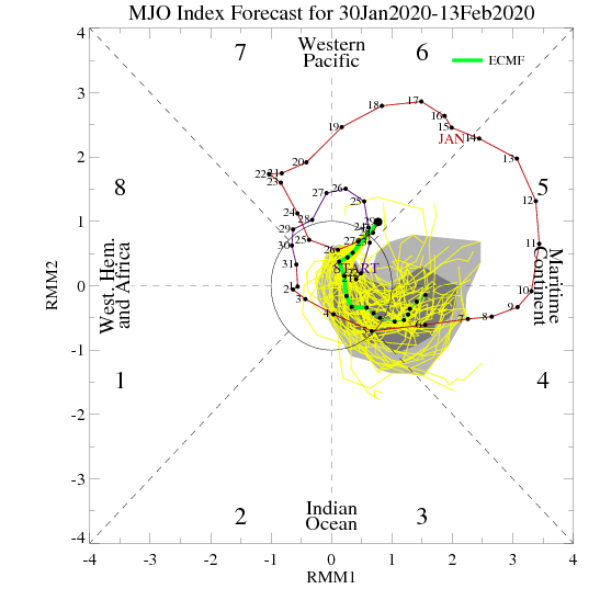
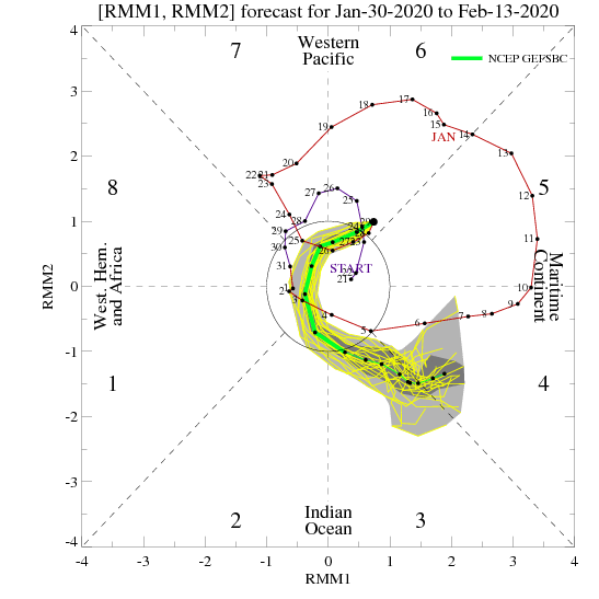
another high amplitude cycle through 4/5/6/7 is likely on the way. 7 is also a warm phase in Feb/Mar so we would have to wait until it gets through that whole rotation again to have a chance at a meaningful pattern flip. The feedback from those phases is likely to pull the pacific ridge back and pump the SE ridge in the kind of gradient TNH pattern we are looking at. I suspect this February will end up looking a lot like last February...except with a raging positive NAO instead of a neutral one. The timing of that next MJO rotation takes us into very late February or more likely March. If, and I have no confidence in this, the PV is more vulnerable at that time...that would be the next window to get a meaningful pattern change. Just in time to get 45 degree rain all spring.
Very doomsday-esque, and well explained.
MJO rotation through all the phases will take way too long. SE ridge is rearing its ugly head. If we finish with <1” at dca it will go down as a major ratter. Tough pill to swallow considering how long we have to wait till December 2020.1 hour ago, Ji said:whats going to transfer it to the coast? Our non 50/50 low or our super postive nao?

Lol, I think we’ve seen every permutation of orange and blue this winter EXECPT the one combination that would produce snow. It’s like it’s trying NOT to snow. I blame all of the negativity on this board. The snow can hear us people!
-
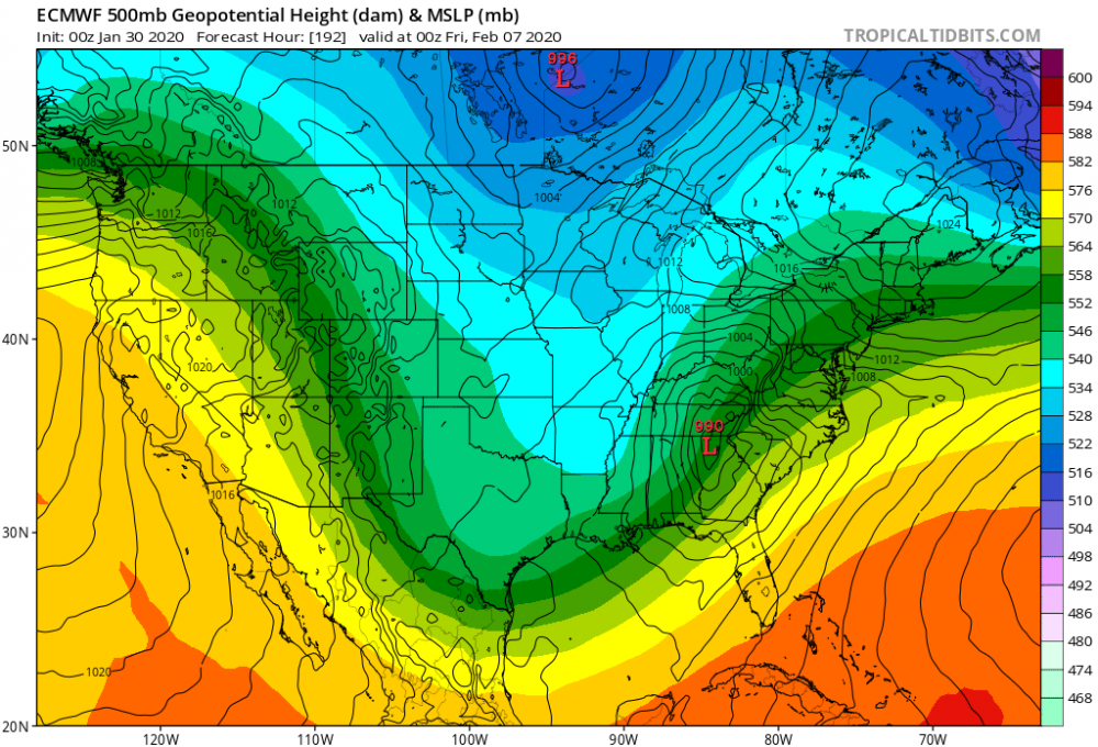
9 minutes ago, Solution Man said:
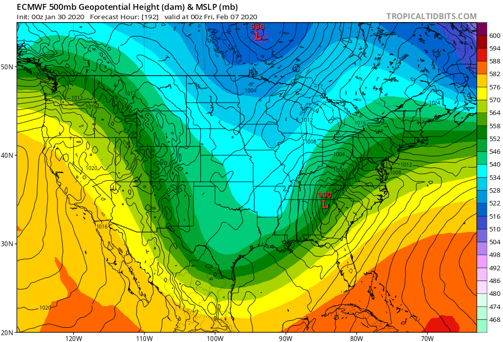
Get that 996 Low out of there
Yea, it’s not helping there that’s for sho
-
21 minutes ago, showmethesnow said:
I am not overly enamored with what the EPS has to offer at this time as well. But it is a look that can potentially work. We really won't know what we have though until we get much closer in time and the smoothing decreases enough where we can start seeing the finer details/smaller scale features.
Very true. That’s the tough part dealing with smoothed averages, it’s only really useful to see (generally) if we MIGHT be on the right side of things. Even then it’s a total guessing game lol.
This is a frame from 0z Euro. Not a horrible overall setup. A couple things break our way and this looks even better
-
1
-
-
1 hour ago, showmethesnow said:
As has been noted by others on the board it looks as if we will have a gradient pattern setup in the extended. That is if the models can be trusted.
If this is the case there are a couple of things I will be watching for. Below we have the Euro day 10/11 500's. Couple of things I want to point out. Note that we are seeing the greatest height builds running from the south and up the east coast. Consequently we are seeing the height lines in the east running up hill in response. Not really what we would want to see as it is pretty much a look that suggests that any energy running the boundary will run to our west and north. And short of seeing the boundary forced way to our south to offset its inevitable push northward with any system this is a look that will probably not work . And currently that doesn't look to be the case as to where the boundary will be far to the south.
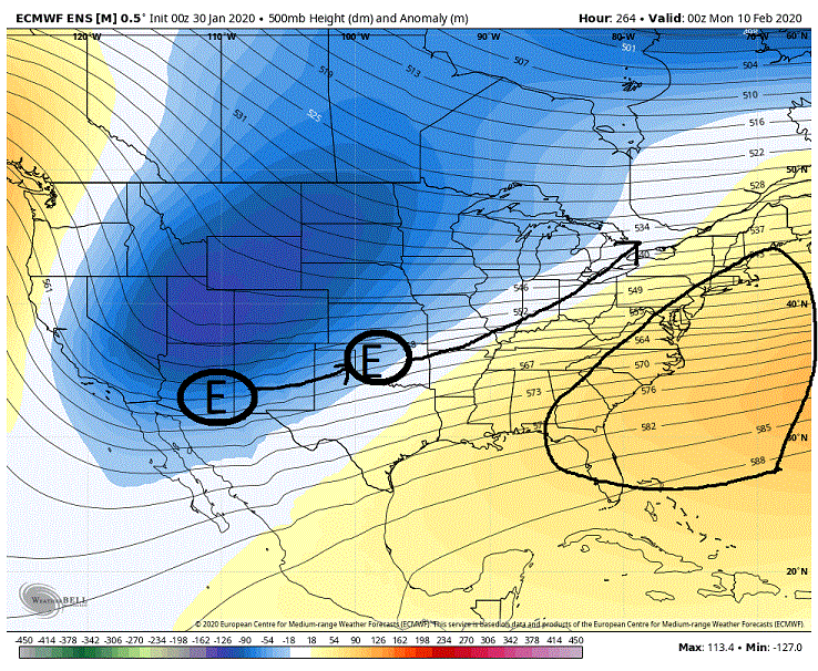
But look what we are seeing day 14/15 on the EPS. Note that the height builds are situated more to the south then the previous example where they were running up the coast thus we are seeing the heights lines running flat through the east (optimal look is to see the height lines running slightly down hill through the east). The reason we are seeing these differences in the heights is because we are seeing a stronger push of the PV towards the 50/50 region. This is a more forgiving look then the previous as it allows for the energy to run more W to E then SW to NE on the previous so we shouldn't see a major push northward of the boundary with any incoming system. This is a look you can potentially do well in if you can get the boundary underneath you by 100 maybe even 50 miles on an incoming system.
*Now there is one word of caution I will throw in here. If you note that the greater neg anomalies are located up in southern Canada. I would prefer to see them farther south into NY or even into PA as they signify deeper, colder air. As is they are possibly suggesting that we might run into issues with the temp profile of the atmosphere even if we can get the boundary south of the region. But given the time of the year that may not be so much an issue.
SE ridge my be back. Been seeing hints of it last few model cycles on GFS and euro has more pronounced boundary setting by up to our west then the GFS...Not a good look attm
-
2
-
-
20 minutes ago, Isotherm said:
@frd -- thank you.
Additionally, I wanted to provide my thoughts on something I saw posted regarding the IO interference and its attendant correlation to the NAO mode. While I am not asserting that the hypothesis should either be rejected or fail to be rejected, concurrently, I would caution [not you, the individual proposing the hypothesis] attempting to attribute a particular phenomenon to the perturbations of a multifactorial index like the NAO. As I've mentioned in previous posts, the NAO is forced via numerous pathways adjunctively, which is why it is more difficult to prognosticate (IMO) than other indices such as the PNA [much more modulated by Pacific based perturbations]. The Indian Ocean standing wave was certainly a factor, among many others, this winter. For example, another factor includes expanded Hadley Cells, driven in part by the SSTA structure, and the macro-scale propensity to intensify the mid-latitude jet in the West Pacific. The mode experienced was really the inverse of what is desired for the coastal Eastern US.
Also, if interested, I posted an updated in my outlook thread which effectively rehashes the thoughts two weeks ago [no significant changes in thinking]. RNA structure February with potential / putative amelioration end of Feb-Mar.
Question
IO interference has a confounding effect along with PNA state that effects the oscillatory nature of NAO - i.e. upper-level velocity patterns (200-hPa) wind anomalies at mid-latitudes (mjo phase 2, Indian Ocean) drive jet stream patterns at our latitude ? Then -PNA mean leads to -AO mean, which typically is found to correlate with NAO state as well... yes?
Thanks
-
Just now, Ji said:
get the EPO a bit more east...and we are on the right side
Lol. “Justttttttt a bit outside”
-
1
-
-
8 minutes ago, Weather Will said:
WB 12K NAM....Won't amount to much but some mood flakes early Sat. could not hurt if it verifies.

Start a thread. We need some good juju. I think you’ve got it

-
1
-
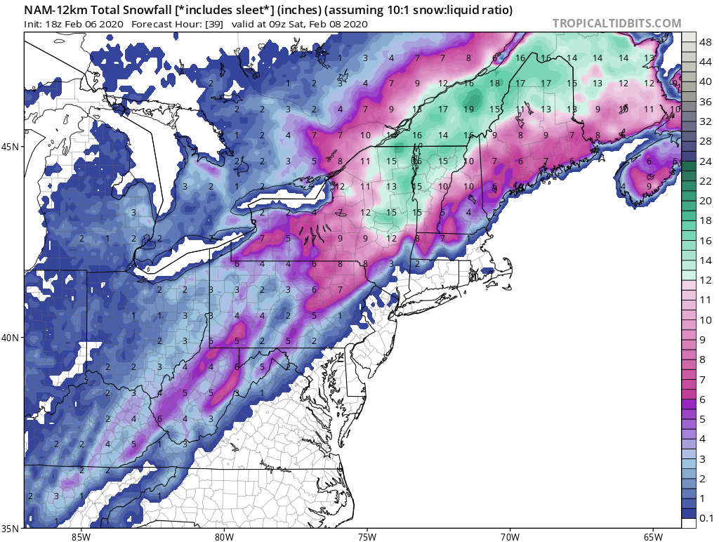


February 5-7 Wintry Mess Potential
in New England
Posted
12z comparison