

PivotPoint
-
Posts
714 -
Joined
-
Last visited
Content Type
Profiles
Blogs
Forums
American Weather
Media Demo
Store
Gallery
Posts posted by PivotPoint
-
-
29 minutes ago, wxtrix said:
then your measurements are false.
And you’re annoying. Not false!
-
 1
1
-
 2
2
-
-
Hrrr continues to look really bad. Might hit the cancel button on this one. I highly doubt Arlington sees much more than a dusting-.5”
Heres hoping for Sunday night-Monday storm
ETA: this thing is absolutely racinggg out of here too. Will be over by 5/6am
-
22 minutes ago, jaydreb said:
0z GEFS is better for DC. 18z was basically a shutout comprised of rainers. 0z is almost an even split of rainers and wintry precip.

E7 right at the BM. Oooo how Id like
-
1
-
-
One thing to keep in mind is that moderate sleet is actually pretty effective at cooling ground that is marginally above freezing. Better job than snow does. So having that before it starts snowing could help surfaces cave a little quicker. Just trying to find the silver lining
-
1 minute ago, ravensrule said:
He is in Mchenry in Western MD.
Makes sense. That’s the money spot attm. Lucky dog
-
It’s be nice to see the northern extent of the precip shield up in pa start to get flattened a bit. A little confluence would go a long way right now to compress this thing down and get these returns moving west to east and filter in a little more cold. Not much right now
-
3 minutes ago, nj2va said:
1.4” so far. Hope you all can cash in overnight/tomorrow morning too.
Where you located again?
That band in Winchester looks tasty assuming it’s. It a blob of sleet
-
12 minutes ago, Deck Pic said:
Agree. I think the upside for us is to get in a band at the right time. But we’re not getting 2” calmly spread across 6-8 hours. I’m shooting for 1”+
Oh, yea. 100%
ETA: Heard a pinger
-
This thing is racing NNW. Looks like dc hugs the snow line. I’m liking md for some decent 3-4” spots. Here in Arlington I’m not seeing more than an inch. Hrrr looks terrible. Not like that means anything though
-
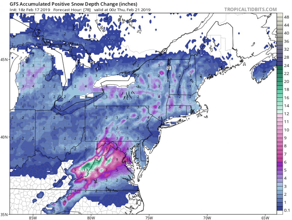
Gfs looks good. This is snow depth change which is more conservative. Take half that for algorithm purposes and it’s still around 4” of sno for dc
. That’s a good solid thump. Don’t like how it’s during the day but if rates are good the. It won’t matter
-
17 minutes ago, osfan24 said:
People really need to stop looking at the GEFS in this type of pattern where so many mixed systems are possible. It's showing ridiculous snow outputs because it's counting a lot of ice as snow.
Unfortunately with no NAO help and a -PNA, the majority of the time that signals a better snow chance for New England.
Ive actually read them talking about how too strong a negative NAO is not great in their neck of the woods. Being the skier that I am I don’t hate that Vermont looks to be bulls eyed next two weeks but I would be pretty disappointed if not one of these waves break in our favor for mby.
I do like the potential for weds-thurs next week for a thump with decent CAD. But that could very quickly turn rain if the shortwave digs too hard considering there’s no back side blocking in the flow with such a negative pna.
-
1 minute ago, clskinsfan said:
Man you guys to east are in for a treat. Picked up .3 in 20 minutes. It is absolutely dumping here.

Hope it holds together. Just light, random fat flakes here. No forcing has really come through yet. Need to get some rates because based on radar we have some moderate returns over McLean right now. If models were accurately counting that precipitation then we are losing our QPF attm with nothing really coming down.
-
1
-
-
I love how LWX trimmed down their totals. And the 1/10 chance max is 3” dc. Even though I think 3” is more than what we’ll receive I don’t understand why they pair down these maps when current guidance is trending more in favor than it did when they had more robust maps up.
Always seems backwards to me when they post revised maps that don’t fit the current trends.
-
Got it. Thanks
The trough does a pretty interesting trajectory. Excited to see how it unfolds
Based off guidance and optimism I still set the bar at a quick inch maybe 2" if we're lucky!
-
1 hour ago, Bob Chill said:
We have a close pass with the tpv and an arctic front going neutral and then negative. I can't think of a single time in the last 13 years that we've had a progression like this. Maybe Feb 14th 2015 but I don't remember the front curling and bowing out like this one.
Might end up a total snoozefest. No way to know yet. I don't think you can compare this progression to all arctic fronts. It's a razor edge but has potenial to surprise. I'll wait until that's off the table before cancelling the event. I encourage anyone with a wxbell sub to scroll through every single ens surface plot. It's really eye opening how interesting this event might be.
Ok, so maybe I’m not evaluating this properly here. You and @showmethesnow seem interested so now my interest is peaked lol
Could either of you explain why this artic front is more unique and why there’s bigger potential then my untrained eye “isn’t” seeing. Thanks in advance
-
1 hour ago, clskinsfan said:
I agree with you to an extent. This one is a little different because all of the models are showing some energy get held back and pass through in time for us to change over. If one was gonna work out this is the way it would.
I would agree with you there. Definitely has been some amount of QPF on most all guidance. I guess I’m just pessimistic against anafronts lol
-
Not sure I see much excitement with this wave passage. Looks like all the rest to me. Looks great now. Not so much in 24-36 hours. The backside seems to be drying out quicker on the 18z gfs. Don’t see a trend on other guidance either that would make me think this is going to yield more than a dusting
-
4 minutes ago, pasnownut said:
Not sure I agree bud.
Anafront snows to me are like atmospheric leftovers....we get whatever is left upstairs. That typically is nothing short of a cartopper at best.
IMO get that front further east and give the caboose something colder to work with and let dynamics do the work. JMO, but I think you understand my point. Its a gamble either way, but to your point and like a bunch of us have been touting, not going to parse over how it snows.....just snow damnit.
Oh yea, totally agree that it’s usally a car topper at best.
However, this anafront has been pretty consistently modeled with the low to our NW helping drag the frontal passage in our area as it passes through (like was mentioned yesterday) there’s enough time for the moisture to flow back over top the cold air. Point is it’s not the “typical” fast moving front we sometimes get that has no corresponding low to our NW creating that elongated/dragging that helps slow the passage just in time as it comes through our region.
My opinion differs in that I do not think the front swings through in time even if we get a low to pop off the SE coast. And if it even does it’s a catch 22 — if the low to our NW gets out of the way and slows the front more to allow for development then it’s probably to warm. If it swings though and the NW low is too vigorous then it probably means a low that pops near us is OTS. All speculation. But I do see your point
-
1
-
-
7 minutes ago, frd said:
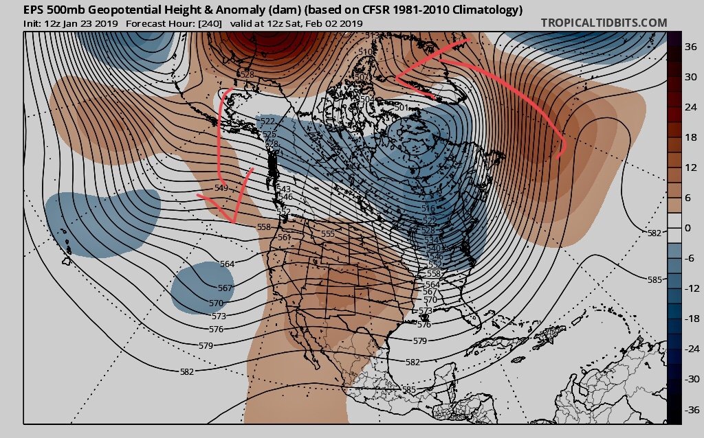
Does this map jog your memory ? From the seasonals and the 46 day snowfall ?
The persistent area of heavy snowfall to our East , very little in the former jackpot zones to our West and SW
Looks like late bloomers and Miller Bs
These maps are guidelines but really useless for the most part, but the look is interesting.
Certainly the only take away here is storms being pushed South of us looks unlikely according to the EPS.
Things are so confusing even Mount Holly had this to say , here with a focus on temps fior my region:
After the system moves out by Wednesday night, the cold
temperatures will be the story. Guidance is trending colder,
which is not unusual as the event approaches. The large Canada
vortex digs into the area, at least briefly, to end the week,
and very cold air will filter into the region. Statistical
consensus guidance has temperatures around 20 in Philadelphia
for highs and around or maybe below 10 for lows for Thursday.
Noteworthy, though, are some large differences among the
individual statistical members. The 00z EC guidance is much,
much warmer (by nearly 15 degrees, give or take) and appears to
be tied to how the Canada vortex pivots after the system moves
out of the region during the middle of the week. In other words,
it will likely be cold, but there are still some questions as to
how cold and for how long. Stay tuned.
Interesting point to this too is I’m not sure a southern system is our best option. Temps out in front of the frontal passage will be in the mid 40s. With the anafront idea we’d have a dynamic temp gradient working in our favor that produces a short but looks to be intense period of snow showers/squalls as the front swings through. This would probably yield as a couple inches if accurate.
With a SS low development the cold air might not be in place yet because the front has not come through. Complex timing here but my gut tells me a southern wave might not have the cold quite there yet.
-
6 minutes ago, Isotherm said:
@PivotPoint, I think the west Atlantic is a "result" forced by other mechanisms, rather than a cause in and of itself. It's partially a function of the upstream dilemma delineated above re: Nina-esque forcing, which, as this ameliorates over the coming week(s), should begin to decrease the WAR's deleterious effects. The WAR is also a function of the oscillating, positive NAO. A classic -NAO features low-heights from the East Coast across the ATL to Europe.
Got it. Thank you
So if PNA ridge axis is in a more ideal spot then that in-turn promotes downstream troughing which can create wave breaks which can contribute to forcing that pumps heights into the NAO... I have that right? Thus, Atlantic ridge is a domino affect of upstream mechanics of PNA, which in large part, are Nina/nino driven during winter months. So since we've been in a weak Nino do we still expect Nino type results with the pna or the Nina-esque as you mentioned...
-
Interesting write up Iso and very informative on the pna. I relate it to the likened of baking a cake -- the pna are the ingredients and the nao the oven. Yes, you need the oven at the right temp to get a great cake but if you start with crappy ingredients (upstream pna) then how much does the temp (downstream blocking) really matter in the end. I know my analogy is an over simplification of the concept. Nevertheless, thanks for your insigh
What's your opinion on how the western Atlantic ridge has fit into the overall EC track and if it really is a spoiler or just seems that way due to (at times) less than ideal placement? Thanks
Good stuff too. In your estimation where exactly do you want the tpv placement to be to allow the war progression into the nao space?
Thanks
-
41 minutes ago, psuhoffman said:
Umm regarding all the mjo talk phase 7 is awful late January and February. We need it into phase 8.
Sorry you’re right. I forgot 8 was better not 7. My bad
-
10 minutes ago, mappy said:
Thanks boo
Nah I’ll leave it. Thanks for your opinion
That’s very magnanimous of you. See, I personally think we have a charming back and forth but who knows.
On to weather:
Just saw the 12z eps and tbh I see some positives in there unfolding day 8-10 then moving forward (hopefully) evolving day 10-14.
As I see it, there’s a decent +pna, neutral/slight negative epo and the atlantic ridge that seems to be retrograding northeast (maybe some into the nao space). If the upper level high situated above Alaska can keep rotating down through pna space then I think we can actually see some sort of split flow develop again as the western ridge gets pumped up. Big maybe but I can see it.
Time that with some tropical forcing and a more conducive mjo phase 7 and maybe we can make this happen begining of February.
-
19 minutes ago, psuhoffman said:
At least when your trolling we all know you want it to snow and your just venting. He was rooting for it to be a disaster so he could annoy us and rub our faces in it.
I thought it was kinda funny. I like the dichotomy, personally. People who take him seriously are missing out on the levity of his character.
People like @mappy can exist to take every comment in the world too seriously but snow(pick a #) is just too much for people to handle. I think we got it backwards
Go ahead and delete this mappy — wrote this one just for you
")


March 3-4, 2019 Snow Discussion and Obs
in Mid Atlantic
Posted
Can someone post the 12z euro snow map please. Don’t have access attm and would like to compare to gfs see how much spread we need to cover over next couple model runs..
Thanks in advance