

PivotPoint
-
Posts
714 -
Joined
-
Last visited
Content Type
Profiles
Blogs
Forums
American Weather
Media Demo
Store
Gallery
Posts posted by PivotPoint
-
-
6 minutes ago, terpsnation said:
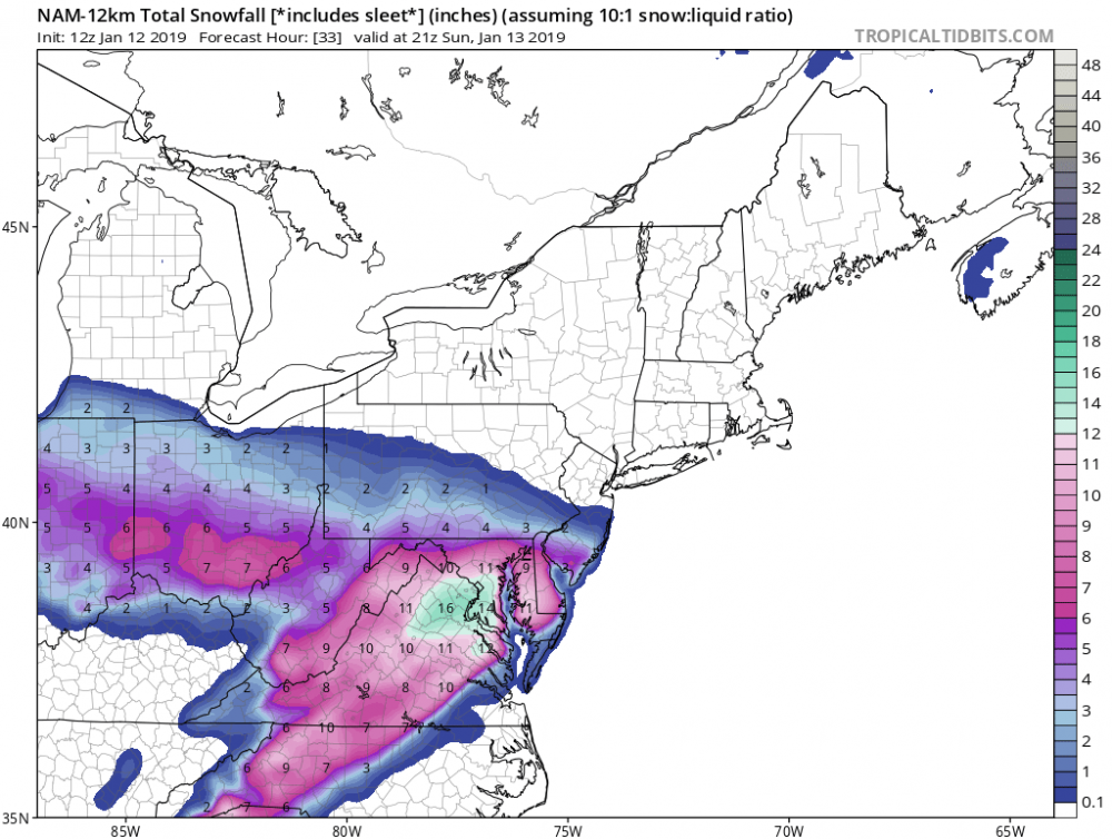
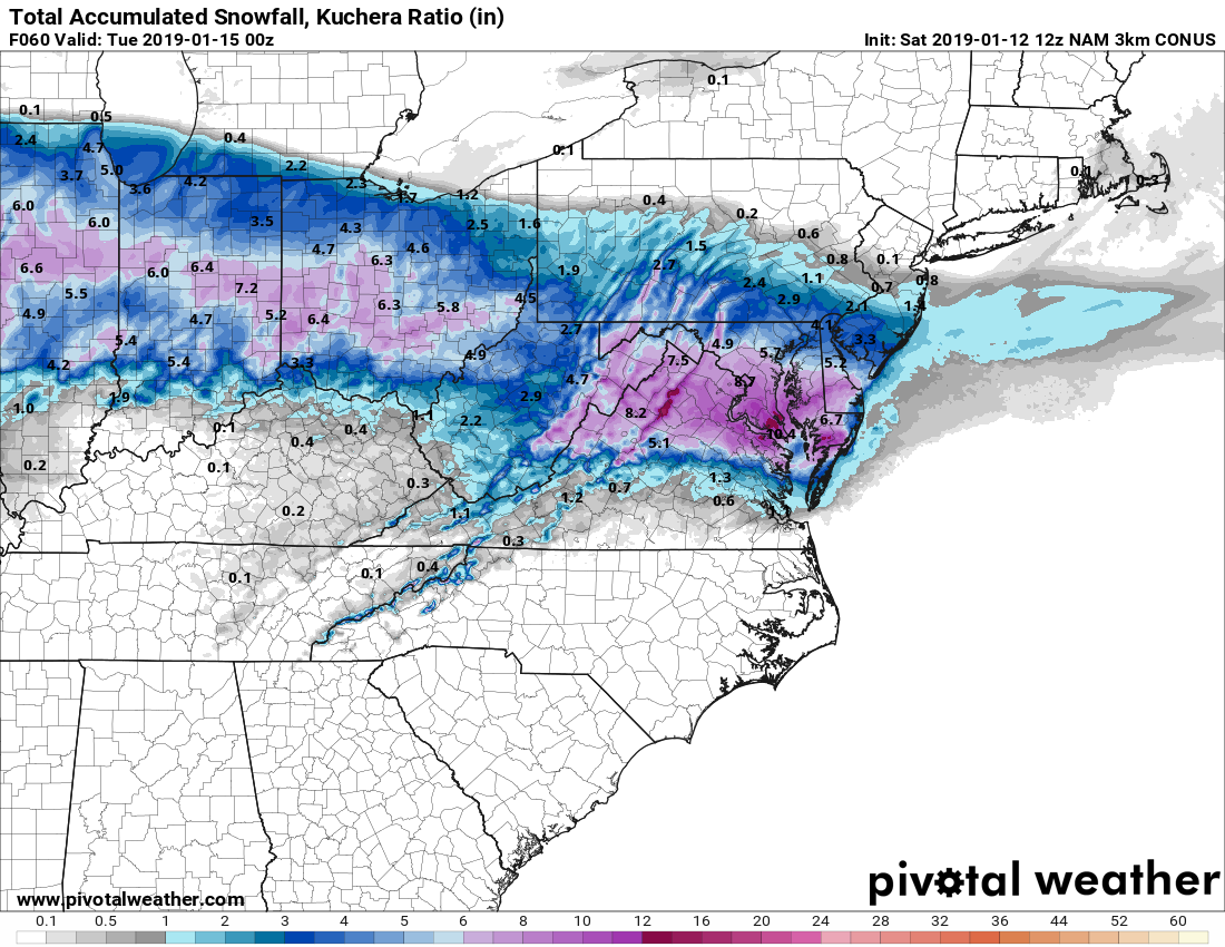
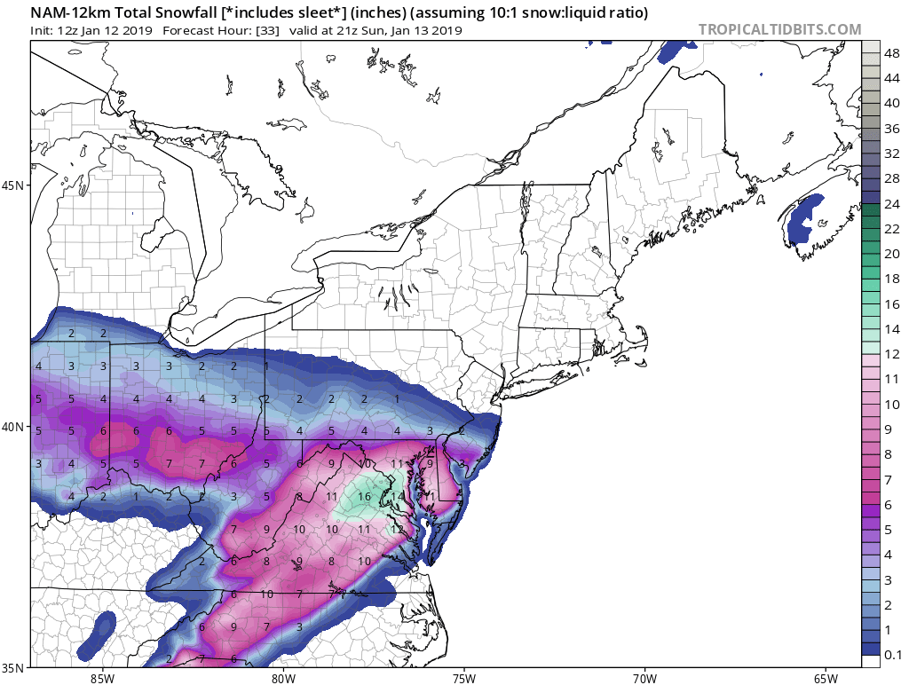
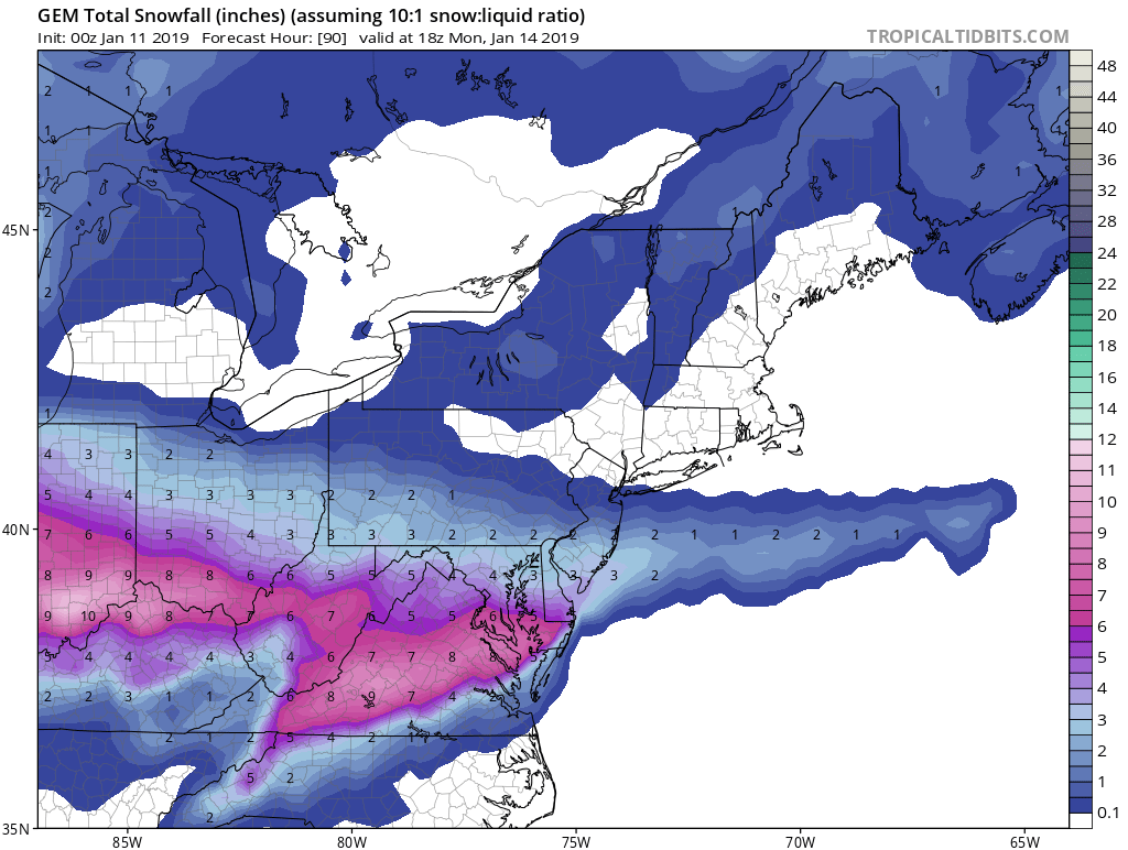
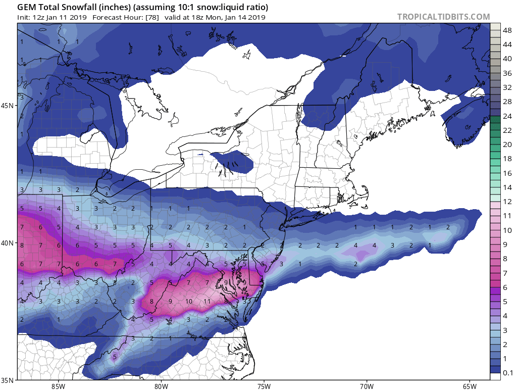
3km Kuchera...

Close to 9” on the 3k nam. Split the difference with 12k and I’ll take my double digit snowfall. Wow. Sipping coffee reading all of this is literally the best thing ever. Thank you NAM for your entertainment.
-
 1
1
-
 1
1
-
-
18 minutes ago, wasnow215 said:
Kuchera poss?
Yea could someone post Kuchera please, just for.. you know
-
1 minute ago, Beachin said:
Absolute destruction ahahahhahahah

The low just literally sits and stalls. Lol
-
It’s still going!!
“And.. the Weenie Run of the Year Award goes to... you got it folks, the NAM!!”
-
2
-
 1
1
-
3
-
-
31.2/14
Clarendon (Arlington)
Surprised we haven’t been upped to a warning. Oh well, here we go!!
-
3 hours ago, Bob Chill said:
Nothing definitive can ever be said about a storm 8+ days away. All we know is there's probably going to be a fairly strong storm during that time. Mostl likely track/ptype and all that can be figured out over the next 3-5 days. It's not nearly as good a setup as Jan 2016 or either Feb 2010 storms. Those were much easier to figure out with the track. Lots of moving pieces on this one.
I remember how the Jan 2016 storm locked in on the models at 8 days away. Never seen anything like that in my life before. Just run after run after run of perfect hits. Once in a lifetime experience to see such consistency with such a monumental hit come to fruition like it did.
-
1
-
-
Just now, BristowWx said:
Elkins?
Oh that makes sense
-
6 minutes ago, Ji said:
Wdca 20 8-12
Q107 4-88-12 where? Nova?
-
1
-
-
8 minutes ago, Bob Chill said:
Fv3's detailed qpf:

Before the blanket stops by and reminds us that it's less than 12z... it's very similar to the euro and right in line with consensus.
Very solid. Looks like euro. Looks like mesos. 18z euro holds within .1 or so range and its all good at that point for a solid 3-5 most places. Im officially in
-
1
-
-
1 minute ago, snjókoma said:
I don't think 0.25" spread out over 12 hours would amount to 3".
I see .3-.4 dc proper. So it’s approx 3-4 inches and more with advertised ratios. I don’t gfs is picking up on the banding and coastal enhancement. I think it’s underdone imo
-
7 minutes ago, yoda said:
Looks like 18z GFS will be a slight step back... but probably noise
18z gfs actually not a step back. QPF bumped to our south. It’s just not in line with the mesos which are showing the banding structure better imo. It’s what their for in these short lead scenarios so I’ll take their word for it unless reason not to. But gfs is same maybe slight improvement south
-
Big run on th nam and still going. .5-.6 DCA and not done. Deform shield more consolidated. This is NAM’s wheel house so hard to totally discount. Still skeptical but as depicted looks realistic given current trend. This might be happening
-
1
-
-
24 minutes ago, Bob Chill said:
Here's qpf. Make up your own ratios

I like the shape of that blue blob. Looks like might be a favorable area for banding. Extend that structure and we are in business
-
1
-
-
1 minute ago, LP08 said:
Let’s just hug the RGEM

I was just about to post that lol
ninja’d
I tell you what too... CMC has consistently pointed at higher totals (little ebb and flow) and better coastal enhancement. The 12z is even better than 0z lol.
If it scores a coup on the gfs/euro I’ll build a mini shrine to it on my desk


-
1
-
-
Just now, LP08 said:
It’s noise. A global isn’t going to nail precip to the .1. I wouldn’t worry. You can see on the precip maps that it’s starting to pick up on banding, etc so the contours will shift around.
Yea I did see the contour shifts and I’m not too worried. Less than I was yesterday that’s for sure! But I’m pretty happy with my call of 2-4” I made two days ago. Has felt that way to me and all the guidance I’ve absorb over last 72hours lol hasn’t really changed that general premise. Chill is probably right, just model noise as we close in. Almost game time so feeling solid at this point for putting a score on the board
-
1
-
-
9 minutes ago, LP08 said:
Gfs holds from 6z. Not much change.
Slight change for my back yard in Arlington. 6z had me 4-5” this is 3-4”. So slight qpf reduction across the area on the whole. Not horrible but definitely didn’t bump up
-
I was definitely feeling deb mode last night. Wake up to some improvements. Great to see euro catch on to them as well. I’ve been conditioned to expect worsening towards game time so it’s nice to see the opposite of that for once! Hopefully we can hold serve till tonight’s run then we’re pretty locked in
-
1 minute ago, Ji said:
I like this particular map...and I think Roger Smith is a burner account for justin berk

That would be sweet except you know that’s not gonna happen. FV3 is JV at this point. Maybe varsity one day but it was one of the last to catch on to the track euro and gfs had two days ago. Might as well be a 3rd cousin to the 84 nam
-
3 minutes ago, nj2va said:
It’s not worth discussing the NAM when its on an island by itself. The “trends” term is overused and misused around here. Every model has the area within 0.2-0.4”. 2-4” is a good forecast.
I agree it is over used however I think I’m using it fine here. Euro 18z down from 12z, correct? Gfs 0z down from 18z and 12z I believe. More Nam comes into range the worse it’s looking. Cmc cut down its totals although still looks good. On a whole multiple models paired down as the event approaches closer. Looks trendy to me
-
Just now, yoda said:
RGEM and GGEM are two different models. I am not sure where you are getting the 1 inch weaker stuff. All models besides the NAM twins suggest 2-4 inches
Sorry, I meant to say cmc. Cmc shows close to 6 and is by far the wettest. And gfs has trended down and nam is close to a non-event. Not trying to deb but I see optimism around which is great but wonder why considering things seem to be slowly unraveling to a very minor event imo
-
1
-
-
2 minutes ago, yoda said:
Huh? RGEM/ICON/GFS/FV3 all are a go for 2-4...
18z RGEM is not 2-4 for dc metro. It’s closer to 4+ and it’s the wettest model now with cmc. Is that not correct??
-
16 minutes ago, yoda said:
Lol GGEM... it cut back from 12z... but it probably makes more sense now
It’s overdone. All other guidance agrees with that. It pairing down is playing catch up. Guaranteed it pairs down every subsequent run.
Im hoping for 2” in Arlington but looks like best guess is 1” considering the WAA looks less and less robust with every run
-
2
-
-
2 minutes ago, DCTeacherman said:
Sure it’s possible but it doesn’t seem like the likeliest outcome since no models are showing that.
You’re right, but we keep losing ground and it soon will be a possible outcome. Additionally, I’ve live in nova for 30 years and have seen the mountains gobble up WAA snows that have taken that approach angle west to east. I hope it doesn’t obviously but I think it’s now more of a real possibility than my thinking earlier today
-
6 minutes ago, DCTeacherman said:
1-3 of snow that sticks is better than our 60th rainstorm in a row...so I’m not mad at this.
But the real problem when dealing in .1-.2 is that might actually mean zero. Seem it happen
-
1
-


January 12-13th Cold Smoke Obs and Nowcast
in Mid Atlantic
Posted
That’s a good point
Eta: seriously they do and the nam albeit prob way overdone might be picking up on better dynamics and enhancement from the coastal. We can hope