

PivotPoint
-
Posts
714 -
Joined
-
Last visited
Content Type
Profiles
Blogs
Forums
American Weather
Media Demo
Store
Gallery
Posts posted by PivotPoint
-
-
30 minutes ago, Maestrobjwa said:
Aren't GL lows more prevalent during Nina's due to them being more NS dominant? Or is it something else?
That sounds right. Our resident (honorary) meteorologist @psuhoffman could probably confirm.
-
3 minutes ago, Cobalt said:
18z EPS has a small cluster of those lows off the shore on Thursday (12z EPS had a few but not as many) . I guess considering that if that followup wave happens, it's 6 days out now, but wouldn't the great lake low ruin the party??

Too many GL lows on that plot. That’s the issue (right now) as well with the day 9-12 time frame. Lots of northern stream action and lows hanging around the lakes. Does this happen with greater frequency due to the cross polar flow that is being modeled?
-
 2
2
-
-
48 minutes ago, IronTy said:
Thanks for the kind words. Also good to hear you're doing so well. So far it's been a classic case of the flu for me:
1. Very run down for a few days wondering why my workouts are so crappy.
2. Whole body starts aching and feels like I'm 110yo with arthritis. Also have weird dreams and night sweats. This started two days ago.
3. Cough starts and headache too. This started today.
So basically a textbook flu for me, just a really amplified one. Next will be the sore throat and stuffy nose. I never get fevers for whatever reason.
I am fortunate enough to have a very well equipped basement gym so I don't even go to the actual gym anymore. But for sure I won't be doing any workouts for a while other than gentle stretching and foam rolling. I'm retired from competition now anyway, I just lift for fun at the old age of 40.
Good stuff man. Sounds pretty classic. Feel better soon brother. Then you gotta get back to those heavy DLs... 40 is the new 25!
On a weather note, lol, check out this crazy map on TT. This is the time period I’m looking at right now. There is some potential for merging right here of the NS and SS. So close to a good storm look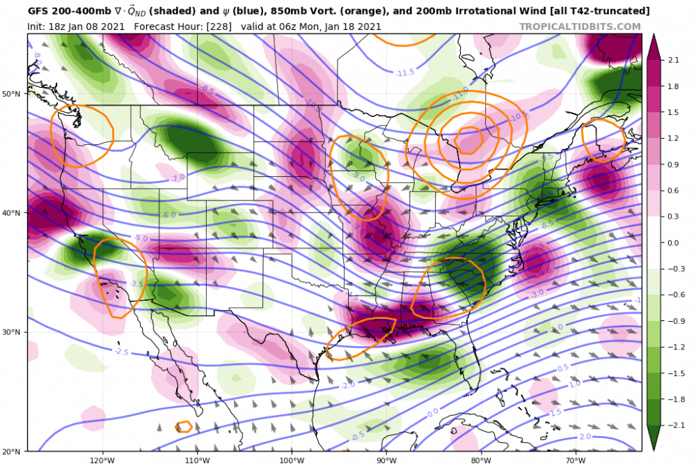
-
1 hour ago, IronTy said:
Good for him I guess. I definitely wouldn't be able to play football this Sunday though. The joint and muscle aches are out of this world and I'm a former competitive bodybuilder so I don't consider myself a slacker.
I got tested Monday and got it. How you feeling so far. I felt a little not ok for about 2/3 days and now feel pretty good. Except I can’t taste or smell. Hope you recover soon. Don’t workout for awhile. Even a couple weeks thereafter. You’ll want to avoid myocarditis.
My regiment has been lots of fresh squeezed juice (I have a juicer) tons of fresh ginger and lemon water. Tons. And the key vitamins suggested for specifically helping with covid. Zinc, d, and a quality multi. Also, eating minimal to limit inflammation and tons of water.
Access to fresh air and I’ve been practicing light yoga and breathing for blood flow and some sort of cardiovascular work. Just very light.Hope it goes well for you. Again don’t work out. I know it’s hard. I was a former collegiate strength coach so yea, that parts rough
-
My fear about the upcoming “good” pattern is starting to seem a bit more substantiated at h5 on recent runs, as we move past the 15th. Lots of sw’s that shear ots under our block and fast flow coming off the eastern seaboard, IN to the Atlantic @psuhoffman thoughts?
-
Para has a slider day 11. It will totally be there next run too
-
24 minutes ago, psuhoffman said:
I hate using normal... to me "normal" should be the median not the average since our avg is skewed by big years. So this is kinda a silly point but my AVG is about 40" my median is about 35". By the "avg" I should be at about 14" by now...so yes even with that one big storm in December I am still running below climo for this date. But not by that much and I am NOT complaining...just pointing out even up here it has underperformed expectations for a sustained deeply -AO. Frankly you would expect to be above climo with that.
Yea but not all -AOs are created the same. Even though it’s like multiple std dev negative the underlying cold is not what one would expect in an anomalous AO state. So it’s almost like who cares it’s negative. The AO is Luke warm to begin with this year
-
1
-
-
3 minutes ago, jaydreb said:
About 35 are whiffs for early next week. The other 15 are acceptable.


Thanks. Yea, so op is not really supported all that much. Still good to see a potential window though
-
48 minutes ago, nj2va said:
Haven’t dug into the individual members but certainly a signal on this panel for a coastal. Get that MSLP deeper and more west but since this is 7 days out, this is a good signal.
and this one

Looks good. Would love to see the individual members for 12z ens
-
Thread title is the kiss of death. Sheesh
-
2 hours ago, psuhoffman said:
There is always that risk in a blocking regime but you have to remember we are too far south for most patterns to work. Absent blocking to suppress the flow we are usually south of the storm track. But take Friday for example. The issue is the blocking is a bit too strong and centered too far south. The ensuing trough in the east gets centered south of ideal. You can see on the means this week the west to east “blue” is a bit south of that “big snow” plot I posted. But if the track was further north we would be just fine. The few runs that did show snow for us were mostly west to east systems too...just they came west to east just under us instead of way down in the Deep South. But it’s unlikely the blocking stays at the current really ridiculous levels. It will wax and wane and during those relaxations we could get a system to gain a bit more latitude or come west to east at a higher latitude. Take that storm that fringed us on the long range GFS last night. That gained no latitude at all. It moved straight west to east but if it comes across 50 miles more north we get a HECS. PD2 was like that. It moved straight w-e until it hit the coast then gained some latitude but not much. PD1 1979 also. We also could get a storm that gains some latitude with a temporary relax that won’t show on a 7 day mean. The slight one day ridging ahead of the storm is washed out on means by the N flow behind the storm. We don’t need a lot of latitude gain. Our ideal track is a primary to TN then jump to NC coast and a latitude gain to about Ocean City. From there ideally we want it to move east.
That said the building positively tilted western PNA EPO ridge later in the period does add more threat of suppression. January 1977 featured that look and it was arctic cold but bone dry. That’s going to flood cold into the CONUS and suppress the baroclinic zone way south. So yea that’s a threat.
But now I’m honestly getting frustrated and here is why. A week ago when the blocking showed but there was still a N PAC trough and not a lot of PNA and no EPO all the debs were saying “but it’s not cold enough in that look we would need a perfect track”. And now that the EPO/PNA ridge goes up it’s “but that could be suppressive”. Ok well what do you freaking want? Those two things are mutually exclusive. You have to dance with one of those devils. Our HECS look actually has less PNA EPO for the very reason you just said. But it’s not a cold pattern and sometimes it’s not cold enough and we get a perfect track cold rain. The epo ridge -NAO is a cold pattern but dryer and sometimes we don’t get any big juiced up coastals. No pattern is 100% fool proof guaranteed to snow.
There’s some good points in there. I think one of the ones I find pertinent is the angle of PNA ridge and that lending to suppression. We’d ideally like that to have a more negative tilt to allow any sw that gets under us to gain latitude without the PNA punting is into a huge block and then OTS. Good points
-
14 hours ago, psuhoffman said:
You mean the flow into the Atlantic? We are upwind not down. They are packed tighter because that’s where the mean storm track is and so you get a tighter thermal zone there. They are more w-e because of the block. Storms cannot gain much latitude under that. And that’s what we want. A minor gain in lat like say from NC to MD before turning east is what we want but that will get washed out on a 7 day mean. Look at the mean for our best snow years. It’s the same feature. A W-E oriented trough from the mid Atlantic across the Atlantic Ocean. That’s a blocked signature. Storms cannot lift poleward because of the block end are forced east.
Yes, flow into the Atlantic. Yea I understand all that. I thought close iso represented tighter pressure gradient this faster wind speeds. Either way, the orientation of the west to east trough seems flat off of the eastern seaboard. The analog composite you showed has that trough slightly sharper and with a more SE component. Small difference but I was saying if we were to fail, by that map, it would be because of suppression and lack of storm development due to the orientation of the trough and flow into the Atlantic. Just saying
-
1 hour ago, psuhoffman said:
I’m not sure what you mean. We need suppressed. Just not too much. But frankly the difference between a DC or a VA/NC border snowstorm is too subtle to show up on a 7 day h5 hemisphere view mean. I could show you a 7 day mean from a DC snow period and a Richmond to Raleigh one and you probably couldn’t tell the difference. That’s just a chance we have to take. Let me post the mean of DCs 15 snowiest winters one more time to compare.
this is a 5 day mean from the EPS centered day 10-15
Yea, I get that it’s a mean. Like I said. I probably didn’t articulate my point properly. Aren’t the iso bars on the 500mb flat and spaces closed together off the eastern seaboard. Wouldn’t that suggest fast flow (ISO’s being close together) and flat (the ISO’s angle is almost horizontal).
Is that not suggestive of a faster and flatter flow off the Atlantic?
-
2 hours ago, psuhoffman said:
Everyone complaining about no cold recently gonna be crying about too much soon watch...


Bring it!
1 hour ago, psuhoffman said:Week 1 might be a bit too much blocking...

but week 2 everything is exactly where we want imo.

And it’s typical we score as blocking relaxes not as it peaks. If we can’t score with that look...
People have been touting this frame as an ideal pattern. And it is a good look (if it happens) but that flow is fast coming off the Atlantic, and the look (verbatim) is more indicative of suppression. I’d like to see that ensemble mean hint at more blocked flow and not so progressive
-
4
-
-
52 minutes ago, Wentzadelphia said:
Agreed, but never doubt backups playing for next years contract lol. I wish we would start Sudfield. I got my 76ers anyway.
ralph I’m surprised the ensembles don’t interest you... this is earlier run but that’s a good signal

Why would you wanna start sudfield?
-
 1
1
-
-
17 minutes ago, Wonderdog said:
6z GFS- Para ends up riding up coast late Friday. NOVA looks to do well according to the run. Don’t know if the ridging out west is where we want it. Maybe someone can comment on that.
Ridge axis not as important here as the storm makes its phase at our latitude under a strong block. We’re hoping that the block doesn’t suppress the SW. the ridge out west is flat but the confluence to the north makes it unlikely to cut. Normally for a GOM low that phases early, wed want the west coast ridge axis to be through Idaho for allow for enough spacing and deepening of the trough so that the NS and SS merge and form our KU. Anyone else want to add
-
On 12/31/2020 at 8:27 AM, yoda said:
This would be awesome news if we could indeed getting any stretch of +pna. We need some help in that department for our upcoming block
-
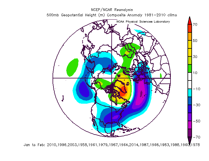
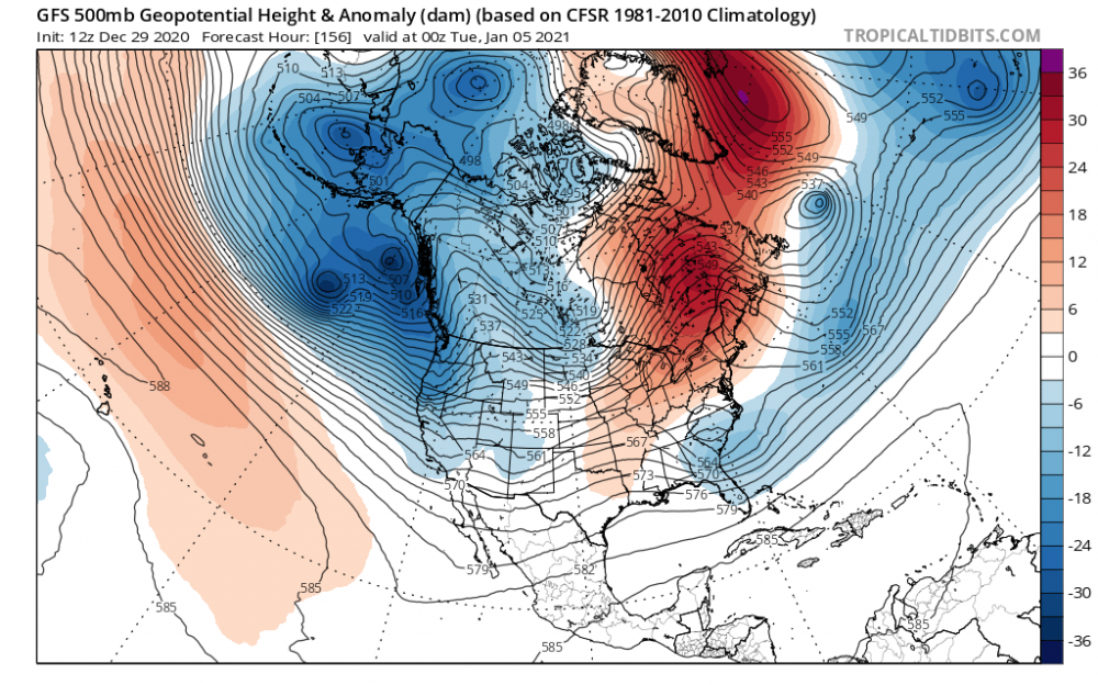
3 hours ago, psuhoffman said:
Deepest trough in the northern Hemisphere showing up over the eastern US. And a tiny spec of “Barney” for the first time in how long...

Now that’s a classic look. That PAC is just right. Still way out though
2 hours ago, psuhoffman said:Their ability to predict the high latitudes that far out is very low. The reason I had confidence in the blocking coming now is it made sense wrt progression of features I could already see and had faith in not in fantasy land ranges. It’s normal for blocking to wax and wane and sometimes a relax is when our best chances come. We don’t want a full break down but I’m not worrying about that yet. Guidance has spooked us many times breaking down blocking at long range only to have it simply be a relax or in some cases not even a relax. History strongly suggests when we see blocking of this magnitude develop it lingers quite a while. I would ride that for now.
Models always try and break down blocks to fast, once the blocking actually comes to fruition. Seen it tons of times
1 hour ago, WxUSAF said:I think we get teased in the Jan 7-15 time period. Maybe something does work out then. It wouldn’t shock me. The difference between “great” winters or periods of winters and “fine” are usually whether we luck our way into some marginal events.
By many numeric indices (AO, etc) we’re going to underperform this December. For the folks north of the Fall Line, it’s going to be a “fine” December. But could have been better. We’ll see what January offers.
I agree with this. I’ve been watching the trends in the GFS and it’s increasing mean H5 trough over the 6-10 day period. The troughs with each sw seem to dig deeper and cut just a little less each run. I actually wouldn’t be surprise if we start seeing some runs in next 1-2 days that pick up on a 5-7 day out evolution. Maybe a piece of trailing energy off one of these apps runners?
-
8 hours ago, psuhoffman said:
I doubt anything cuts there. But out airmass at that point is still pretty abysmal. It’s going to take a couple waves and cold air drainage in the NW flow behind them to fix that. I remember a similar situation to this early in several blocking regimes that started with pac puke airmasses. Specifically I remember an exact clone to this discussion in early January 2016 when long range guidance hinted at a cutter...and we had this same exact exchange, and it ended up not cutting but was still rain. Because of the general warmth the primary hung on too long (not had there been cold but too long when we have a crap airmass) and it ended up a big old rainstorm anyways with a pretty good track. I could see that here. I agree with Wxusaf that we could luck into something with a perfect track. It’s not impossible. That block will likely keep us close and tease us. But until we get some cold into the east (probably around the 15-20th) it’s not going to be a high probability imo.
Well at least we’re all on the same page now! I like the progression of the west coast. And the extreme events up in the Aleutian/AK makes me feel that an extreme (hopefully) ku solution is a possibly even in a neutral/Nina-light background. I know the ku scenario has virtually nothing to do with crazy strength of storms rolling up in the northern lats, but still, very interesting
24 minutes ago, frd said:That was one extreme wave 1 event.
Pretty cool. This is interesting
-
4 hours ago, WxUSAF said:
The H5 looks on all guidance are excellent by mid January. But 850 and 2m temps are still mild at that point. Going to take a bit of time to get some cold air moving south, but that much improved Pac will do that eventually.
You summed up in two sentences what I couldn’t in like 4 posts lol.
3 hours ago, psuhoffman said:My guess is around the 18-20th is when we start to rock. It’s possible one of those waves in the Jan 10-15 works but a long shot as the antecedent airmass is a train wreck. But the thermal profile over the conus will slowly cool in mid January with a flow out of northern Canada. Maybe we get lucky with something amplifying and doing the mythical “create your own cold” thing sooner but I think we have to be patient.
So above is exactly the argument I was making. 2m temps would lag behind a good upper air pattern. Why did you push back against what I was saying.. this was my point earlier
-
15 minutes ago, psuhoffman said:
@PivotPoint you’re arguing apples and oranges then. For about a week starting now the pac trough crashes into the west. That’s a problem. That has to back off. But that has not been the case all winter so far and it looks to only last about a week. No one has said we want that trough on the west coast. But getting it to back off slightly to be centered back where it has been most of winter so far isn’t a big change or reshuffle it’s just the pac resuming its base state so far this cold season. We have not had a legit NAO block yet. We did have a AO crash and it did produce cold and legit snow threats. If we get a legit NAO block with the pac base state we have had most of December we will be fine.
Fair enough: I went back and checked the PNA tele for past 60 days and you’re right, it’s more neutral to slightly positive than I had thought. I don’t think we’re arguing apples to oranges as you said, but I guess my focus for winter is always mid dec- mid March. After the spike in the PNA for our dec 9 storm, it’s been pretty flat since then to now trending negative over the next 5-7 days. My concern is everyone is saying “but look at day 10+” ridging and blocking. Great, I think we all have seen that exercise in futility with the day 10+ deal. Listen, if you recall I stared woofing for the dec storm on dec 1 because I saw transient ridging in the NAO domain and a ridge forming out west as the GOA low migrated poleward. I said then I liked the day 7-10 period. I didn’t get hit but a lot did. And it was great. So, not just nay saying. I bark when I see things. Maybe you’re seeing it sooner, thus, congrats. I’d like to see the PAC better in the day 7 timeframe to feel better about our future block
eta: apologies, got my dates confused: dec 17 storm and started discussing it on the 9th
-
4 hours ago, LP08 said:
Your points are for sure valid for the next 10 days and I tend to agree with you. I think what everyone here and on Twitter is saying is the 12-15 day and beyond (I know dubious but all guidance has it). +5 temps in eastern Canada is still plenty cold for our source area for a good storm track. The December storm had the H5 go north of us and never close off until it was well past us and it still was a good storm for many. I think what everyone is trying to say is that we don’t need below normal anomalies in Canada in mid Jan for it to snow here.
This is a good point. I am looking a little more medium range as anything beyond the day 10 period is just pureeee speculation. You can have hints here and there but mostly confirmation bias if it actually turns out to be correct. I do think that we see some PAC help simply because troughs out west don’t last forever. However, I’ll say it again, surface temps could become an issue for us closer into the city (as they always are) but as a finance guy, I would be hedging my bet against temps being cooperative. I would argue there’s a greater chance we DO get upper air to look right but the surface struggles (even more so than we usually do) just my wag
4 hours ago, Kmlwx said:We don't even need a "cold outbreak" to get snow during climo favored times. In fact, we've seen plenty of times when a massive cold outbreak suppresses stuff to the south and we get shafted in that manner. Give me "cold enough" to snow and I'll take it. We don't need some frigid Arctic outbreak to get snowfall here.
Nobody has mentioned a major arctic outbreak or even calling/asking for that. I do think though that given our “new” base state for background temp that seeing +5 anomalies in our source makes me (dc and se) feel EVEN worse about our snow chances then I usually do. But I hope PSU and Cape et. al are right and the blocking overcomes this marginal temp look of the northern lats
3 hours ago, dailylurker said:Those of us east of DC pretty much do. That's probably half this fourm.
I tend to agree here. Marginal for leesburg on west means we mix the ENTIRE TIME, instead of the usual 70/30 snow to snizzle ratio we get for most mil a’s or overrunning will flip sooner, etc
1 hour ago, clskinsfan said:GFS starts bringing ridging to the west coast on the 11th and 12th. Has a monster cutter during that time frame. But the pattern looks better after that.
A model run 13-14 days from now. You have a better chance of guessing a number 1-100 that I’m thinking of right now then that look coming to fruition as depicted, lol
As long as there are small improvement improvements out west over next 6-10 days then the blocking has a chance to help. But I’m not looking at 12+ days out into fairytale land.
-
37 minutes ago, psuhoffman said:
We have never done well in a Nina without blocking. Ever. So your assertion that we should toss the blocking doesn’t have any historical support. NAO phases often last months so your idea that it could break down then reform in time to save the end of winter is dubious. We do not want a ridge where that N PAC low has been. We want a ridge centered over eastern AK into western Canada. That N pac low has been, and guidance suggests will be again, centered west of AK. Most of our best snowstorms have a low there. If you put a ridge there you will get a trough in the west and a ridge in the east! If you are only talking about the one week coming up where that low becomes a monster and crashes into western N Amer then yes that needs to back off. That does temporarily flood us with pac puke next week. But that’s only temporary not the permanent base state. It’s a result of a sub 920 low crashing into the Bering sea. Assuming that pulls back to where the N PAC low base state has been it’s fine Imo.
Correct, I was referring to this...the day 5-10 time frame where there is a trough extending from the N. PAC through AK and down through west coast.
I would think we would want ridging there that extends up and over AK/BC. And to your point yes, La Niña would need blocking based off the fast pacific flow and west coast trough that’s more indicative of a cold enso. But my point was not a) completely do away with all ideas of blocking, and b) allow those cold anomalies you see diving down the west coast to move eastward to central Canada. We would not see cold out here, correct. Not a good winter storm look but would (in my mind) possibly set the stage for more cold out breaks if blocking reloads and there is evidence to suggest blocking (once stable) can wax and wane
-
25 minutes ago, Ralph Wiggum said:
We haven't had a block yet. It is just showing up on the 8-12 day now. All of this 'blocking" you are referencing were higher smoothed height extentions from the WAR that is about to break off and wobble into the western NAO region as a true block. We get it, your blinds are shut until you see cold air up North and a channel to get it down to the US. I dont agree with that as yes, temps have been AN in our source areas but temps have seen seasonal here and seasonal/marginal will work imo when the actual block settles in. Patience.
We’ve had easy based -NAO. And it’s kind of muddled because yes it is an extension of the WAR but it’s hard to tell if it’s all an extension of the WAR or not. Yes though, the west based blocking is still modeled out in time so patience is a must
-
1
-


January Long Range Disco Thread
in Mid Atlantic
Posted
Lol. I was like “really. Come on man.” He’s not wrong