

PivotPoint
-
Posts
714 -
Joined
-
Last visited
Content Type
Profiles
Blogs
Forums
American Weather
Media Demo
Store
Gallery
Posts posted by PivotPoint
-
-
10 hours ago, CAPE said:
Did you consider anything else, or did you arrive at this conclusion by glancing at a single h5 height panel? There are some pretty significant changes depicted between now and that period, which you aren't going to see on that h5 mean.
I checked h5 and vort panels. I also zoomed out to include all of northern hem to see epo, NAO, west pac, and SER. Didn’t think think the overnight runs were very inspiring.
10 hours ago, Ralph Wiggum said:That is not a zonal flow look on a smoothed LR means at 354hrs as posted.
Yes it is. Or pretty close to it. Flow is pretty west to east. Here’s an educational graphic for you
-
 1
1
-
-
That look doesn’t inspire me. It screams zonal flow as wentz mentioned above. Anytime we rely on NS waves to cross over the Allegheny to deliver us snow, we lose lift and moisture and are left with flurries or maybe an inch (if were lucky. We need our block to retro East a bit and allow a PNA yo build. Cycle that block back down as a wave gains steam out of the central plains/gulf coast and we’re in business.
-
1
-
-
5 hours ago, psuhoffman said:
But what if the pac isn't fixable...some of us are focused on ways to work AROUND the pac...because that jet isn't going anywhere...its been a non stop thing for 5 years! So we can either try to work around it or just give up!
Oh, I’m not giving up. I’m with ya. We’re going to get some flat wave NS stuff soon, at least that looks as much right now. Hopefully we reorganize that west coast ridge and activate the SS as we progress through February. Feels like forever since feb has been rocking. We’re due
-
1 hour ago, frd said:
I have been reflecting and feel when we talk about threat windows, intervals of + PNA , transit ridges it really means we are in trouble.
Anyone whom doubts the Pac needs to reassess in my opinion. SSWE, - NAO, - AO , - NAM state, HL blocking, etc., etc., mean nothing , all that really matters is that the Pac cooperates and that Canada doesn't torch in December.
When I see some - SD deviations on the Canadian 10 mean and see the Pac improve instead or worsen only then do I feel we have a chance at something more than a pity event.
Look at how this PNA has evolved.
I said the same exact thing like 3 weeks ago and everyone was like, "the Pac doesnt need to be perfect to get a storm". Thats an exact quote. And although I agree with that statement my comments and context was never for a perfect setup on the PAC side. But I made the point that UNTIL that cooperates, then who cares about all the great pieces in the atlantic and poleward. But nope, everyone criticized me for being a Debbie.. Mmhmmm
-
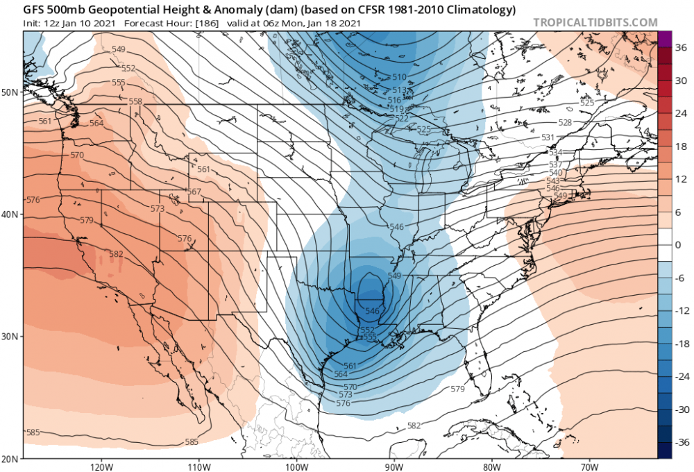
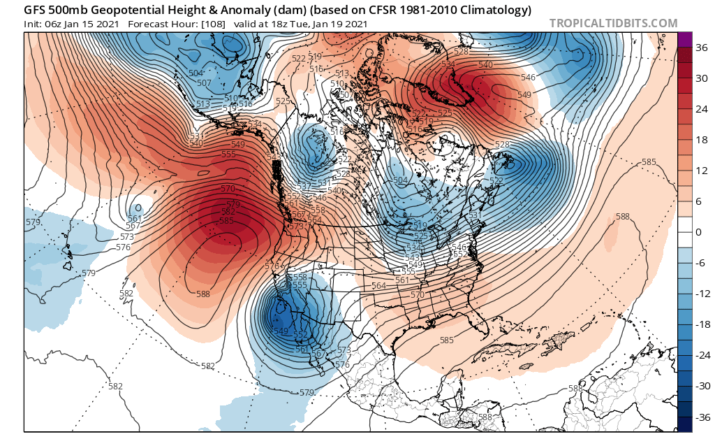
This is interesting. Our issue now is one I wouldn’t have expected.
You can see below that this h5 looks like a decent setup - ridging out west, trough diving east and some confluence up from our departing system.
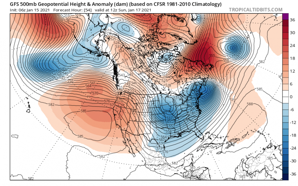
But our trough has no energy to work with and doesn’t dig deep enough and we get a dry and cold solution. But then (the interesting part) we this crazy ridging and almost full blocking in the pacific that forces all theses NS pieces of energy into the southwest - even so much as to move energy east-west and capture the energy UNDERNEATH the west coast block. Crazy
The frame before this you seen the NS energy decent south then merge with SS energy and little backtrack through the southwest. What does this do - it pumps up riding and heights ahead of the flow creating and even greater shear factory across the middle of the country. Not allowing for any amplification or spacing to develop between vorts.Finally as we move through time you can still see the intense west coast ridge/blocking causing a break in the NS energy as it try’s to make its way east. Again, it shoots energy straight down the west coast and pumps heights to the east. It’s a vicious cycle even though we have good blocking to our north, with a 50/50 at times. We just have no mechanism to allow NS and SS to interact.

In my mind (to fix this) we need the huge AK ridge to reposition and create a split flow scenario where the angle of the NS is more oriented BC to central plains, then AK straight down the backside of the west coast where we lose all of energy and potential for interaction. I think a reshuffle of that ridge, and a couple warm days for us as that breaks down and hopefully reloads in a more ideal spot would do wonders IF we can also cycle our blocking up top. Perhaps one of those big pacific storms could do its dirty work in the PAC and reset that h5 look on the west coast, a bit
-
3 hours ago, LP08 said:
Decent Signal day 10 and beyond on the EPS.

Wait... your saying day 10 and beyond looks good? Stop the presses! This is shocking news
lol
-
1
-
-
1 hour ago, Ji said:
i mean it kind of falls into the progression that PSU has talked about. That its the next one after the next one
Nah man, it's the one after that one.
And the "real" storm is the next one after the next one after the next one. Winter 2023, it's gonna be ridic
-
8 minutes ago, psuhoffman said:
It’s a -AO/NAO. It’s not a bad pattern. But the pac is offsetting it. It still does force that wave further east then we would see without it. It secondaries. But can’t save us. There is no antecedent cold. If there was that pattern would be fine. We can cry about the fact that a pretty darn good pattern isn’t doing a freaking thing for us and I’m with you. It’s crazy. It’s scary. But what I’m saying is obviously a simply -AO isn’t doing it. If we need to step it up the true Rex block that can exert a lot of pressure on the upstream flow doesn’t kick in until day 7/8.
Got it. Thanks
-
Is this not technically blocking

-
2 minutes ago, osfan24 said:
It's a billion hours away. Stop over-analyzing.
Yup, just said that above. I agree. Good point
-
25 minutes ago, nj2va said:
I'll let someone way smarter than me confirm, but wouldn't you expect a 50/50 low and western ridge to show stronger on an ensemble mean than a random azz gulf low 15 days out?
I never said they should look the same as those features I was just making the point that those dominant atmospheric features (which are more constant, yes) shows in the mean. A slight mean pressure down south that represents are little blue area could simply just be a blip from one ensemble run to the next, which guess what, (earth shattering news coming) it probably is just a blip! So relax. Differing opinions are ok, and realize there HAVE been stronger long range, mslp ensemble looks down in the gulf. NEVER said once that this particular look wasn’t good, just said it’s not a strong signal. Why are we still talking about this? It’s all minutia anyways and pure speculation
-
2
-
-
6 minutes ago, psuhoffman said:
You expect as deep a pressure along the gulf coast or southeast as a vortex in the North Atlantic?
I’m making the point, PSU, that the 318 ensemble mean low heights in the gulf are great, awesome, but I’ve seen maps where there is a stronger signal there. That’s all I’m saying.
Geeze, you guys are wound too tight right now. We also ALL KNOW that it probably WONT happen anyways, so my point is even more valid. Yea, the look is great but we’ve also said that 646,876,239 times in the past month and what do we have to show for it.
Ive have seen lower (and darker) blue down there before — would you disagree?
-
10 minutes ago, nj2va said:
Dude, its a smoothed 324H mean. It's not going to show a parade of 982 LPs riding along the coast. I'll take my chances with a 50/50, blocking, and lower anomaly pressures in the heart of climo any day.
The constant search for a PERFECT pattern is tiring and a waste of time.
And also. If you read my previous posts I said that I liked the overall “futuristic” setup in the LR. I was pointing out that the mean heights in the southern tier, even for an resemble mean, was not highly suggestive. Which that look could change too. I never said it won’t happen or isn’t going to happen. Simply look at the strong features on the map. That wasn’t one of them
-
7 minutes ago, nj2va said:
Dude, its a smoothed 324H mean. It's not going to show a parade of 982 LPs riding along the coast. I'll take my chances with a 50/50, blocking, and lower anomaly pressures in the heart of climo any day.
The constant search for a PERFECT pattern is tiring and a waste of time.
3 minutes ago, WxUSAF said:It’s a D13 ensemble mean dude.
Yep, understand that. But if you look at the intensity of the western ridge and the low heights off in the eastern Atlantic, those are strong signals (and means as well) for those features to be present in 13 days. Means work both ways, and the strength of those mean features is stronger this more reliable, imo to come to fruition then a barely present mean low look in the souther tier
-
1 hour ago, psuhoffman said:
This is an excellent look. Mean H pressure to our NW with low pressure running the gulf states and up the coast...

To be fair, that’s not what I’d call a “strong” signal southern lows. It’s intensity it’s pretty paltry, comparatively
-
 1
1
-
-
2 hours ago, frd said:
Rain at 330 hours GFS and 240 GEM. Yea I know OP at range , but we need a real game changer. Same thing last 24 months, cutter, coastal hugger or inland runner.


The para has that 240 time frame as well as the euro showing a low somewhere in the vicinity of the Tennessee valley and the gulf. So, that’s a good sign considering gfs-reg and gem have a signal there too
19 minutes ago, psuhoffman said:EPS has a big signal for that range around Jan 25-26. So does the gefs. West to east type wave as blocking relaxes some. Way too far out but it’s there. Remarkably similar on both ensembles
Yea, I noticed that. I think the ensemble guidance is starting to converge on the blocking and building heights out west. I’m starting to be intrigued now. I never bought this early pattern development with the PAC look at western pac ridge. Now signs of epo ridge and west based block... I’m seeing a light around Jan 22-31
-
3 hours ago, psuhoffman said:
But that’s a permanent issue with the pac jet blasting in. It’s irregardless if the NAO. I’d still rather have a good longwave pattern over N Amer then not when trying to overcome that issue. Going forwards as the pac ridge shifts poleward it should help mitigate that some.
Exactly. I also think a building epo ridge will help us cutoff that pac flow. And if our block can retrograde a bit more west then we can definitely score then. I saw hints on the eps of the blocking progression. End of January could ACTUALLY be a go or able period, imo. Like, no no more pushing out in time.
-
7 hours ago, psuhoffman said:
Yes
I said a week ago. The potential fail potential with the upcoming “good” pattern was fast flow shredding sws. Psu remembers. I’m like halfway decent at this hobby now
-
5
-
-
1 hour ago, Wentzadelphia said:
Agreed, but I can see it now, we get shutout until the st paddy’s day Flizzard of 2021.
Corrected it for you
-
3 hours ago, psuhoffman said:
I was actually saying that was a pretty good setup. It’s not perfect. More wave separation and a 50/50 would be ideal. But a displaced TPV lobe diving in and phasing just to our west is a way we have scored before. It can cut inland if the trough amplifies too far west so it’s not this sure thing can’t fail look. Get more spacing and a 50/50 and it becomes that. But I was saying that tpv there makes getting higher heights in the lakes impossible. But so long as the low is behind the southern wave and not in front it’s ok. The way that works is the cold is locked in long enough in front then by the time the lakes low would screw us the coastal takes over and the mid levels close off and the lakes low becomes irrelevant. That only works if the NS isn’t dominant like the gfs and ggem showed. The euro was all NS and that won’t work. To make my point look at the 12z gfs run. The mid levels stay cold enough. We’re rain because it is just too warm at the surface despite a closed circulation and saturation. The lakes low wasn’t really a huge issue it was just too warm at the surface. That’s sad for Jan 19 with a bombing low off the coast!
Oh, I get what you’re saying now. But my point was is that if there’s no phasing then those lower heights act as confluence as opposed to amplification. My point was if it made not going to phase into the SS sw then I’d prefer it were out of the way all together.
-
Tracking sucks right now. 18z gfs with a big whiff. Has zero snow through Jan 26. I guess we’re building up cred for next years massive HECS. This blows
-
 1
1
-
-
1 hour ago, psuhoffman said:
Imo the same thing that has been...we just don’t get lucky in a decent to good longwave pattern. This year the problem hadn’t been a failure of guidance to see the pattern. It’s been the failure of mostly a decent to at times good pattern to produce anything. Imo the pathetic lack of cold for the pattern is the culprit. Yea it’s snowed in TX and TN and NC but they were all isolated upper level dynamically driven events with a really narrow expanse. If you were to look at a snowfall mean map so far more places are struggling then doing well. There have been scattered local hits because the track of SWs has been pretty good (good longwave pattern) but without cold and a lack of good baroclinic boundary due to that systems are pathetic at the surface and lack a big expense of snow that makes it more likely for us to cash in.
Agreed.. and I’m not sure I gathered what you were saying earlier. You were saying that the upcoming h5 setup in the 7-10 day range is more indicative of how we fail then how we usually succeed? Because of the TPV being displaced this far south? I understand that we don’t want the TPV centered in the southern central CA but not sure what your explanation was for a ridge out west and lower heights in the southern tier being a fail setup. Seemed like the heights around the lakes were keeping our trough from turning negative and moving up the coast. What am I missing
-
1 hour ago, psuhoffman said:
Btw after looking like a wreck the other day the GEPS has trended to the GEFS and has a very nice look days 7-16
Days 7-16 you say?
What could go wrong

-
1
-
-
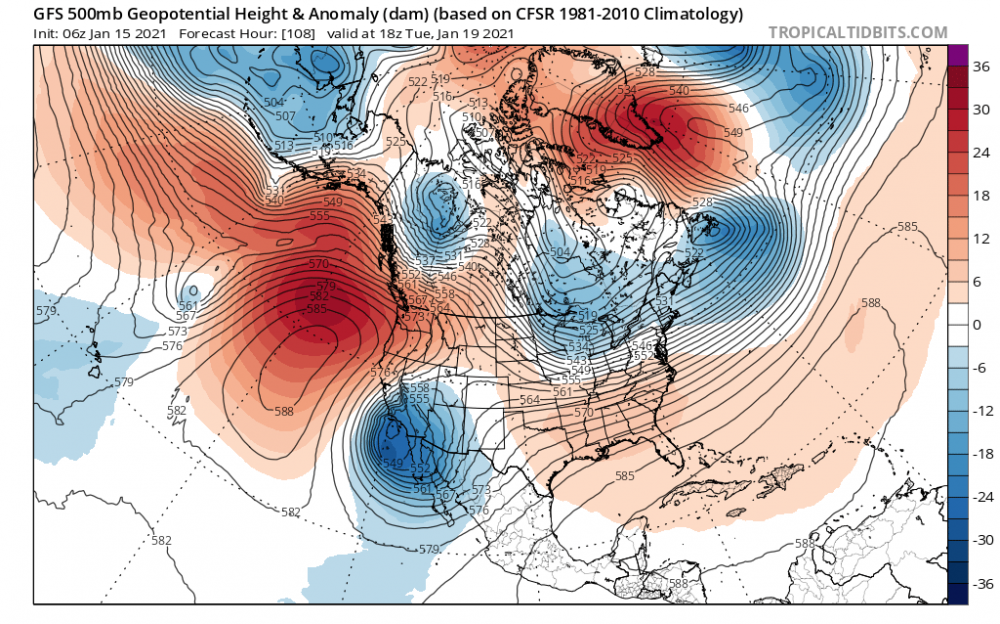
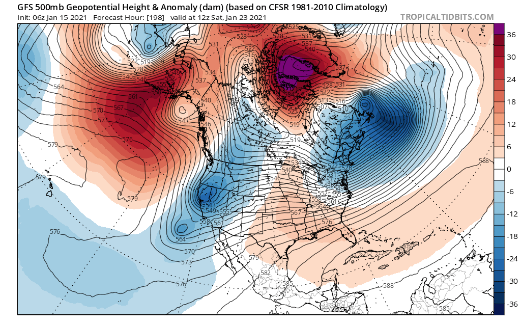
5 minutes ago, psuhoffman said:
The signal for the 19/20th has only become more pronounced in the last 24 hours. All the parts are there. Severely displaced TPV in southern Canada. Colder antecedent airmass. -NAO. Very nice wave depth and alignment signature. But the details models will not get accurate at this range will determine exactly how it plays out. No sense getting upset over those details that will change every run for another couple days. 150 hours seems to be about the magic spot where the globals start to hone in on some synoptic level details. We’re still 2 days from that.
I will say this about the 12z gfs. If we get a big rainstorm on January 19th from a 984 low 75 miles east of Ocean City with a closed h5 low track across southern VA and a TPV just north of Michigan I am done for the year and I mean it. That’s absolutely ridiculous. And don’t someone tell me how this or that was 2.5 miles off from being perfect. If that setup doesn’t get us a snowstorm we’re wasting our time.
The good thing is it’s only 7ish days away. Not super fantasy land. We just need to get rid of these low heights around the lakes and move a stout high to our NE. This h5 is pretty darn close to a thumping though


Feb Long Range Discussion (Day 3 and beyond) - MERGED
in Mid Atlantic
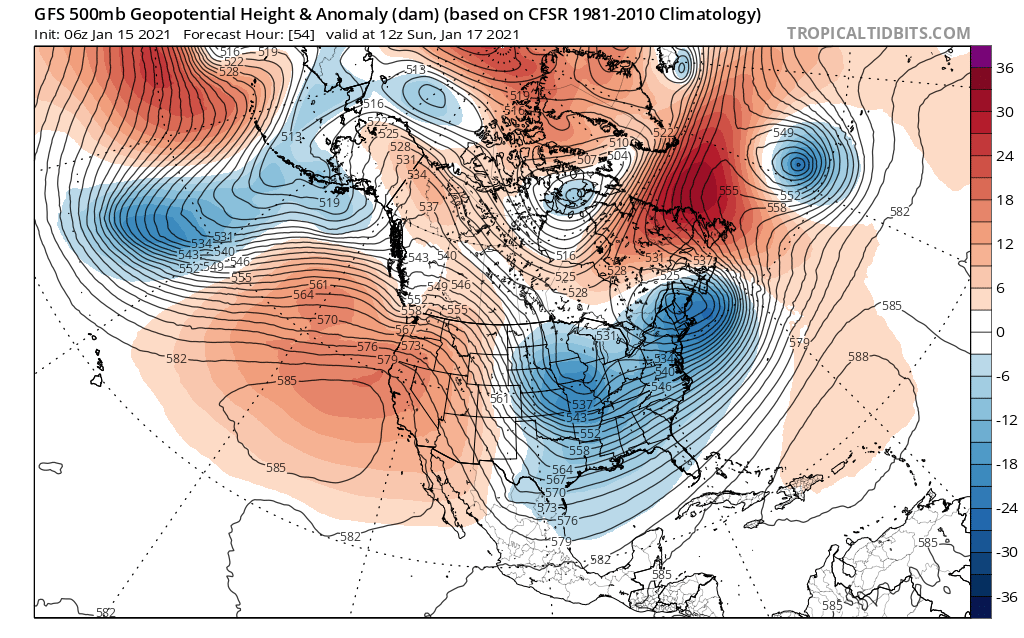
Posted
Agreed. You can see the inter mountain ridge here better at 250, but if we’re talking entry point on the west coast and exit on the east coast it’s fairly zonal, with the caveat of a northern dominant flow. Not saying all panels are like that but that’s what I saw at h5 and 250 when I looked at the 6z gfs