CAPE
-
Posts
36,849 -
Joined
-
Last visited
Content Type
Profiles
Blogs
Forums
American Weather
Media Demo
Store
Gallery
Everything posted by CAPE
-
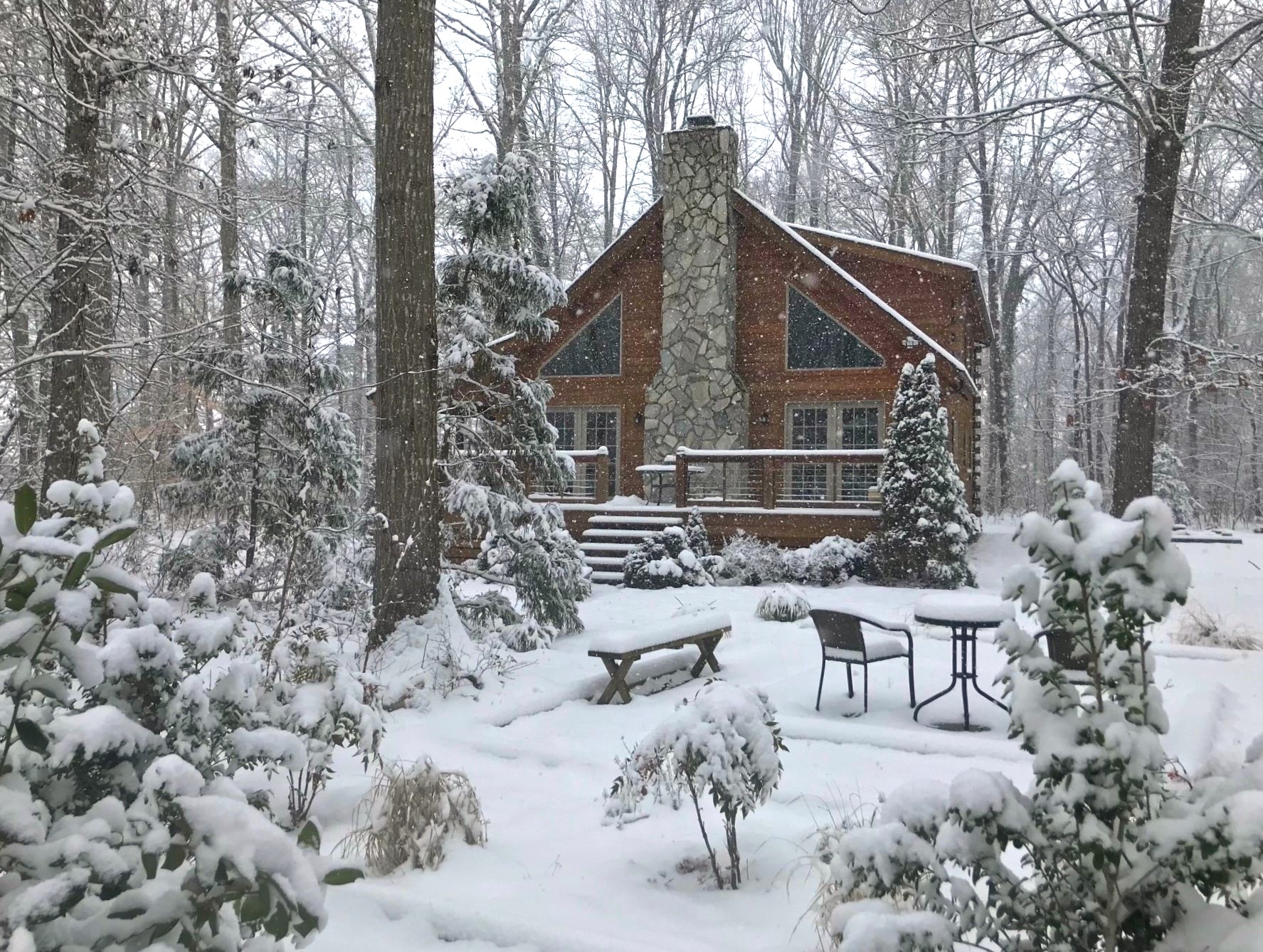
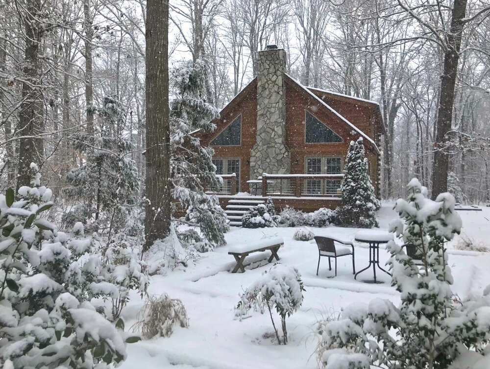
Right at 4". Average of 5.5 snow depth in the yard. Took this when I was out shoveling off the front steps a little while ago. Temp 31.
-

Southern MD / Lower Eastern Shore weather discussion
CAPE replied to AnEndlessMaze's topic in Mid Atlantic
Right at 4" now. Too bad it isnt a few degrees colder. Would be less compaction. -
Radar looks impressive down there. Kinda wish I were at DFH brew pub sipping a WWS watching it come down.
-
The way it was looking this morning I wasn't sure about 3 lol. Forecast is 3-5..would be nice to max out.
-
Nice band setting up now. Some yellow in there on radar.
-
Best rates since early this morning here now. Bigger flakes. Over 3 inches but can't be bothered measuring atm.
-
Just home from work. 2.5" so far despite a nearly 3 hour lull this morning after that initial heavy band. Steady light to moderate snow now. Temp is 29.
-
Southern MD / Lower Eastern Shore weather discussion
CAPE replied to AnEndlessMaze's topic in Mid Atlantic
Just got home and 2.5" here. Steady light to moderate snow falling. -
Southern MD / Lower Eastern Shore weather discussion
CAPE replied to AnEndlessMaze's topic in Mid Atlantic
That sucks but it will go over to snow. -
Southern MD / Lower Eastern Shore weather discussion
CAPE replied to AnEndlessMaze's topic in Mid Atlantic
Radar is beginning to fill in nicely now. Maybe we can overcome this 3 hour lull of occasional pixie dust that all the guidance seemed to miss. -
Southern MD / Lower Eastern Shore weather discussion
CAPE replied to AnEndlessMaze's topic in Mid Atlantic
It's trying to blossom a bit. Might be moderate snow at my place now. Wish I would have charged the damn battery on the security cam. -
Southern MD / Lower Eastern Shore weather discussion
CAPE replied to AnEndlessMaze's topic in Mid Atlantic
Based on the 'trends', Mount Holly upped the totals for my area this morning to 3-5" from 1-3. Maybe 3 is doable. We'll see. -
Southern MD / Lower Eastern Shore weather discussion
CAPE replied to AnEndlessMaze's topic in Mid Atlantic
Dover radar is back up. At least we can properly track the pixie dust lol. Looks like some better returns moving eastward over the bay. Need that to blossom some. -
Southern MD / Lower Eastern Shore weather discussion
CAPE replied to AnEndlessMaze's topic in Mid Atlantic
The late south trend on guidance is going to bust. NS systems rarely work out here. The places that were progged to get the best lift over the last several days are are getting it. My wag is the forcing for this afternoon will be less expansive than guidance is depicting, and probably not as impressive as what is occurring over N central MD now. -
Southern MD / Lower Eastern Shore weather discussion
CAPE replied to AnEndlessMaze's topic in Mid Atlantic
The HRRR has picked up on the zone of nothingness that didn't seem to be present on any model I looked at this morning. Looks like the best forcing will shift over towards DE this afternoon. Hopefully we will get in on the edge of that. Latest HRRR halved snow totals for my yard lol. -
Southern MD / Lower Eastern Shore weather discussion
CAPE replied to AnEndlessMaze's topic in Mid Atlantic
Ofc Dover radar is down again lol. -
Southern MD / Lower Eastern Shore weather discussion
CAPE replied to AnEndlessMaze's topic in Mid Atlantic
With the shift southward it looks like central and even parts of southern DE are going to benefit from the lift associated with the inverted trough this afternoon. Latest GFS has 5" for Dover to 3" for Lewes. -
I thought I would be ahead of it on the drive in. Came in hot and heavy. Despite all the salt, roads caved immediately and visibility was low. Snow became notably lighter towards Easton.
-
Just started snowing here. I'll be off to work in 30 mins. Drive back might be fun. Mount Holly evaluating the model trends. Now have a WSW for DE. This is their 2am update- As we head through the overnight, the latest model guidance has continued a shift south, focusing the inverted trough extending westward from Friday`s coastal low back closer to the Delaware coast rather than southern NJ. Dewpoints have been running slightly lower than forecast, signaling some low-level dry air that will be initially tough to overcome as light snow aloft continues to spread toward our region from the Appalachians during the predawn hours. Still looking at light snow arriving generally between 5 and 7 AM, with it just entering eastern West Virginia and far western Maryland between 1 to 2 AM. Much of the guidance suggests that the steadier snow will focus more on southern NJ into Delaware at it`s peak this afternoon, and linger there longest as the coastal low pulls away, dragging the inverted trough behind it. While higher snow ratios may make up the difference for a bit less liquid equivalent precipitation along the northern edge of the steadier snow, all these indications suggest that we`ll have to adjust some of our totals downward somewhat north of Philadelphia to Tom`s River or so. Will continue to analyze the data over the next few hours.
-
Southern MD / Lower Eastern Shore weather discussion
CAPE replied to AnEndlessMaze's topic in Mid Atlantic
Yeah our area is on the southern edge again. NS systems are touchy here. There is a general shift south on latest guidance though. 1-3 for the mid shore seems reasonable. -
Qualifies as deep winter around here. Twice as much snow would be better ofc. Forecast for here after the snow tomorrow- Saturday Areas of blowing snow. Increasing clouds, with a high near 26. Blustery, with a northwest wind 10 to 15 mph increasing to 15 to 20 mph in the morning. Winds could gust as high as 35 mph. Saturday Night Areas of blowing snow. Partly cloudy, with a low around 16. Breezy, with a northwest wind 15 to 20 mph, with gusts as high as 30 mph.
-
Weenie nature. Always greedy. IMBY thing mostly. Time for an old fashioned.
-
Not bad, but verbatim I prefer the 12z run.
-
Jan 19th Snow on Snow: the this always works until it doesn't thread
CAPE replied to psuhoffman's topic in Mid Atlantic
Natty blend good trend -
32 Still full snow cover here in the woods. Last snow on snow was early Jan 2 years ago.