

40/70 Benchmark
-
Posts
78,558 -
Joined
-
Last visited
Content Type
Profiles
Blogs
Forums
American Weather
Media Demo
Store
Gallery
Everything posted by 40/70 Benchmark
-

December 2025 regional war/obs/disco thread
40/70 Benchmark replied to Torch Tiger's topic in New England
18z. -
2025-2026 ENSO
40/70 Benchmark replied to 40/70 Benchmark's topic in Weather Forecasting and Discussion
I buy it for MBY. -
First Winter Storm to kickoff 2025-26 Winter season
40/70 Benchmark replied to Baroclinic Zone's topic in New England
There is just too much data. -
First Winter Storm to kickoff 2025-26 Winter season
40/70 Benchmark replied to Baroclinic Zone's topic in New England
I would definitely lose it if I get skunked, and interior se MA has a nice event. -
First Winter Storm to kickoff 2025-26 Winter season
40/70 Benchmark replied to Baroclinic Zone's topic in New England
I am. -
First Winter Storm to kickoff 2025-26 Winter season
40/70 Benchmark replied to Baroclinic Zone's topic in New England
It wasn't a serious post. -
First Winter Storm to kickoff 2025-26 Winter season
40/70 Benchmark replied to Baroclinic Zone's topic in New England
As long as I get like 4", I'll be fine...but less than that, I'll probably have an early melt. -
First Winter Storm to kickoff 2025-26 Winter season
40/70 Benchmark replied to Baroclinic Zone's topic in New England
The reason you have this impression is because it's run more often now, which provides more opportunity for error, but it is actually more accurate in the mean. -
First Winter Storm to kickoff 2025-26 Winter season
40/70 Benchmark replied to Baroclinic Zone's topic in New England
Don't worry, it will consolidate into a blizzard in time for that fat, bald dude to do his obnoxious siren video, and collect another 5,236 followers. -
2025-2026 ENSO
40/70 Benchmark replied to 40/70 Benchmark's topic in Weather Forecasting and Discussion
Not necessarily....it depends where it's located because a strong vortex located in the vicinity of James Bay is the coldest pattern there is. -
2025-2026 ENSO
40/70 Benchmark replied to 40/70 Benchmark's topic in Weather Forecasting and Discussion
@Stormchaserchuck1I am just north of that 60, where the arrow is pointing.....60% shot at 3"+ according to the EPS.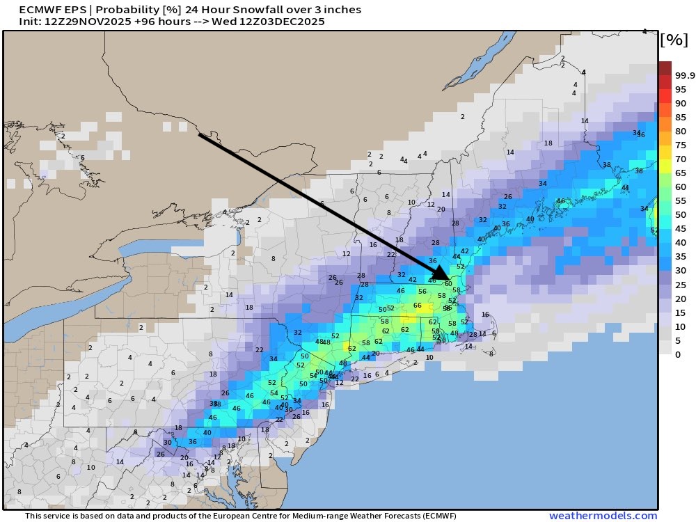
-
First Winter Storm to kickoff 2025-26 Winter season
40/70 Benchmark replied to Baroclinic Zone's topic in New England
Yes, this was never going to be more than 8" IMO. -
First Winter Storm to kickoff 2025-26 Winter season
40/70 Benchmark replied to Baroclinic Zone's topic in New England
I just gave it a quick eyeball....matched up generally speaking, I didn't compare it that specifically. -
First Winter Storm to kickoff 2025-26 Winter season
40/70 Benchmark replied to Baroclinic Zone's topic in New England
Whooooosh. -
First Winter Storm to kickoff 2025-26 Winter season
40/70 Benchmark replied to Baroclinic Zone's topic in New England
I'm just mocking Kevin's inane outbursrs. -
First Winter Storm to kickoff 2025-26 Winter season
40/70 Benchmark replied to Baroclinic Zone's topic in New England
The whole thing has gone to crap. -
First Winter Storm to kickoff 2025-26 Winter season
40/70 Benchmark replied to Baroclinic Zone's topic in New England
DT's First Call map looks like mine. -
2025-2026 ENSO
40/70 Benchmark replied to 40/70 Benchmark's topic in Weather Forecasting and Discussion
I'm not doom and gloom...I went 19-29" for you on the season. I'm just not as optimistic about December as the consensus for your area. -
First Winter Storm to kickoff 2025-26 Winter season
40/70 Benchmark replied to Baroclinic Zone's topic in New England
I would be fine with an advisory event. -
2025-2026 ENSO
40/70 Benchmark replied to 40/70 Benchmark's topic in Weather Forecasting and Discussion
Maybe I will be wrong on some aspects, which is fine...I'll learn from it....but all I ask from those who comment on my work is to accurately reference what the forecast was. -
2025-2026 ENSO
40/70 Benchmark replied to 40/70 Benchmark's topic in Weather Forecasting and Discussion
Keep thinking what? It's not subjective...I told you what my forecast was...that is objective fact. -
2025-2026 ENSO
40/70 Benchmark replied to 40/70 Benchmark's topic in Weather Forecasting and Discussion
I used December 2000 as an analog for the warming in that it would narrowly miss a reversal, but also mentioned December 1981 as an example if it were to actually reverse. I said that the MJO would staddle the border of MJO phase 8 and perhaps make it into phase 8 at a reduced amplitude, which would allow other factors to potentially modulate the pattern. And I'm not sure how in the hell you are grading the nuances of the 500mb composite for a month that has yet to begin. You are absolutely desperate for snow in Central Park, I get it. -
2025-2026 ENSO
40/70 Benchmark replied to 40/70 Benchmark's topic in Weather Forecasting and Discussion
I stopped reading your response right there. Either you didn't actually read my outlook, or you're illiterate to some extent. -
First Winter Storm to kickoff 2025-26 Winter season
40/70 Benchmark replied to Baroclinic Zone's topic in New England
Just see how EPS trended. -
2025-2026 ENSO
40/70 Benchmark replied to 40/70 Benchmark's topic in Weather Forecasting and Discussion
I have explained my forecast rationale in quite vivid detail, so if the logic is still lost on you, the issue is not mine. I will be sure to pay particularly close attention to how much the I 95 cities south of Boston receive in December. Good luck-


