OHweather
-
Posts
5,043 -
Joined
-
Last visited
3 Followers


About OHweather

- Birthday 09/01/1992
Recent Profile Visitors
7,111 profile views


-
We heard (and felt) the sonic boom from the meteor at the office in Brooklyn Heights, and then dealt with a barrage of phone calls and media requests that rivals a major severe weather event. What a day. Also saw some gnarly snow squalls today (and drove on some icy roads last night and this morning) as March does its thing. I believe that 85mph gust at Burke on Friday was the strongest gust measured at the site.
-
It’s always fun to guess if the low CLE measurements are real, or a product of “measurement difficulties” at an open airfield. In this case the snow was mainly upslope driven so they definitely got less, but it’s possible the measurement was still a little low there since it was pretty windy. I can say in Brooklyn Heights there was dramatically less snow than even 2-3 miles farther inland most of the day, it was pretty remarkable.
-
I had 3” during the day yesterday and a little over an inch more overnight. My total since Saturday night came out to 8.4”. In terms of counties needing warnings, it was really close in a few. The upslope definitely was more impressive than expected. The tricky aspect is the storm totals are impressive, but occurred between Saturday night and early Tuesday morning which is a very long duration. The heaviest snow was during the day yesterday and it was struggling to consistently cover main roads due to the higher sun angle for several hours. Still, some areas got over 8” and a <24 hour span which is getting to the point where it’s hard to look the other way. I’ll be looking closely at Medina and Geauga in particular…a few spots in Cuyahoga, Summit, and Erie Co PA were close to that as well, but Medina and Geauga seem most impressive overall.
-
The upslope has been performing quite well all day (arguably over performing). It’ll be confined to a narrow strip along the higher terrain from Medina to Geauga, but it seems like spots in there will come in with 6-9” type amounts. I got close to 3” overnight, pushing my storm total to 4” as of 7am. It’s been snowing pretty good at home all day, so I’m expecting to come home to over half a foot on the ground. Not a bad event, not really an impressive setup but the upslope is really pulling it out for the favored areas.
-
Had a bit under an inch here as of 10:30 AM, since then it's been snowing lightly at times but largely not accumulating. It looks like the best push of snow will be late tonight/Monday morning in the Cleveland area and NE OH snowbelt...west of Cleveland may see a half decent uptick late this evening, along with late tonight into Monday. Overall not the most exciting, but winter is back and the higher terrain/upslope areas should see snow add up to several inches by Monday night.
-
The squalls didn’t disappoint, at least where I’m at. Slept through a good portion of it, but it was nearly a whiteout when I looked outside and it looks like I’ve gotten 2-3” of new snow since 6pm.
-
There was definitely more freezing drizzle and less snow than hoped this morning. Upstream honestly looks a little underwhelming, but there’s still a bit of time for stuff to pick up before the front gets here.
-
Recently tallied up my seasonal snowfall, and I'm sitting at 67" to date. Last season, I had 68" all winter. Friday's system looks like a nice refresher of the snowpack. It's more of a lobe of the polar vortex than a regular clipper...there will be synoptic snow in the warm advection ahead of the system Friday morning and afternoon, which looks like a quick 1-3". The more dynamic portion will be Friday evening/night, when an Arctic front pushes through. That should bring a nice burst of lake-enhanced snow (looking at satellite, the ice is still somewhat lose and has cracks, so there should be a limited flux from the lake), along with rapidly falling temperatures and strong wind gusts. It'll only last a few hours, but conditions will be quite harsh along and just behind the front Friday evening. Some limited lake effect lingers Friday night into early Saturday. The snow Friday evening through early Saturday probably adds a variable accumulation of 1-4" to most of the area downwind of Lake Erie, pushing event totals into a 3-6" type range.
-
After getting a little over 7" of synoptic snow through Sunday evening, got a little over 3" of LES overnight Sunday night through Monday. Event total of 10.4". Today, had about a two hour period of light to moderate snow late morning, followed by two pretty decent snow squalls in the early evening. Another 2.2". What a stretch of cold and snow! Could use a little warm up soon though for sure!
-
The strongest lift was focused above the preferred dendritic growth zone (DGZ) for most of the storm…so flakes were forming in a part of the atmosphere that was too cold for good crystal growth. It seemed like there were bands of higher ratios across parts of NW OH, and then down towards central OH ENE towards YNG, with lower ratios in between. It’s not uncommon to get bands of higher/lower ratios based on where better banding sets up, and is not easy to predict ahead of time unfortunately.
-
The fluffy lake enhanced snow last night into this morning has been a nice bonus…I was a little over 7” for the synoptic snow, but was at a running total of 9.6” this morning after the overnight lake enhanced stuff. A few spots may add 2-4” of fluff today. The lake enhanced snow will make most of the totals look nicer in the metro area.
-
1/24-1/25 Major Winter Storm - S. IL, IN, and OH
OHweather replied to A-L-E-K's topic in Lakes/Ohio Valley
Fluffy/efficient lake effect processes occurring beneath/within a broader synoptic snow are basically magic in terms of getting good snow, but it’s rarely organized into a firehose like what’s been going into Toronto. -
1/24-1/25 Major Winter Storm - S. IL, IN, and OH
OHweather replied to A-L-E-K's topic in Lakes/Ohio Valley
Glad the lake effect came through for the Chicago folks! -
Yeah I’ve been underwhelmed by this in the Cleveland area. I’m at 6” or so right now…one more better band to swing through the next few hours then it’s down to off and on lingering lighter stuff through Monday. The drive in this morning was pretty bad, the drive home was not any worse, so it just wasn’t snowing much during the day at times. The snow to liquid ratios at some of the airports through 1 PM was near or only a little over 10:1, so I think the big issue was we needed ratios to come through for bigger totals and we largely have struggled to make good flakes most of the storm. Overall it’s still a warning level snow in what’s been a cold and snowy stretch, but am a little bummed that despite last minute upticks in guidance until pretty much hour 0 we’re finding a way to come in on the disappointing side around here. Par the course for synoptic snows I guess. The Canton and Youngstown areas have or will clear a foot, so it was close.
-
1/24-1/25 Major Winter Storm - S. IL, IN, and OH
OHweather replied to A-L-E-K's topic in Lakes/Ohio Valley
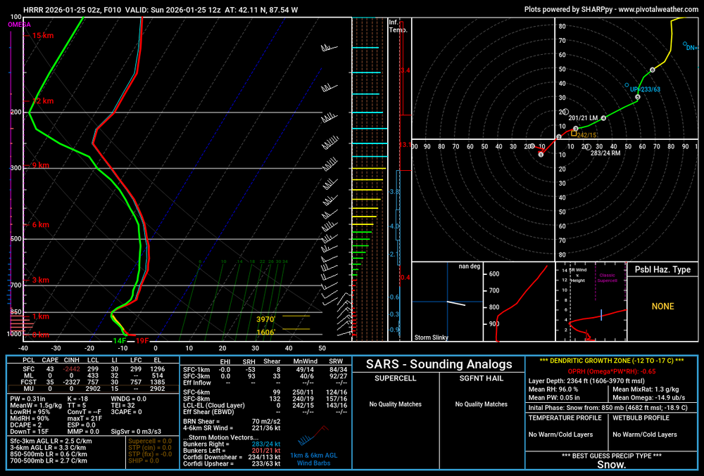
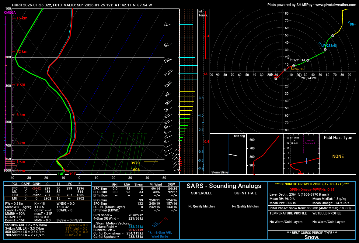
Even though the lake effect affecting the southwestern shoreline of Lake Michigan tonight into Sunday is rather shallow, forecast soundings within it depict strong low-level instability with lift maximizing in the DGZ. Supportive of relatively intense and very fluffy/high ratio lake effect. If the band can sit over an area for several hours...which may be possible somewhere over NE IL or far SE WI within a few miles of the lake...there's definitely local overperformance potential into the 6" range.