KeenerWx
-
Posts
846 -
Joined
-
Last visited
About KeenerWx

Recent Profile Visitors
6,255 profile views


-
Love these types of mornings. Low 70’s and stormy.
-
Pulled this from IEM for LOT, 1/1-3/31. Looks like most active start by a good margin in the last 20 years when considering all modes. 2026: 5 watches, 59 warnings, 135 storm reports 2025: 4 watches, 36 warnings, 92 storm reports 2024: 2 watches, 32 warnings, 80 storm reports 2023: 1 watch, 16 warnings, 25 storm reports 2022: 2 watches, 18 warnings, 23 storm reports 2021: 0 watches, 0 warnings, 0 storm reports 2020: 2 watches, 4 warnings, 4 storm reports 2019: 1 watch, 16 warnings, 16 storm reports 2018: 0 watches, 1 warning, 1 storm report 2017: 3 watches, 45 warnings, 62 storm reports 2016: 2 watches, 11 warnings, 12 storm reports 2015: 0 watches, 0 warnings, 0 storm reports 2014: 0 watches, 0 warnings, 0 storm reports 2013: 0 watches, 3 warnings, 3 storm reports 2012: 1 watch, 6 warnings, 8 storm reports 2011: 0 watches, 6 warnings, 5 storm reports 2010: 0 watches, 0 warnings, 0 storm reports 2009: 1 watch, 14 warnings, 16 storm reports 2008: 2 watches, 17 warnings, 4 storm reports 2007: 3 watches, 8 warnings, 4 storm reports 2006: 4 watches, 7 warnings, 25 storm reports Keep saying this, but March has been incredible when you consider all the svr action, warmth, & yes - snow for some.
-
A couple solid boomers but nothing noteworthy. Pretty satisfied that we continue to get an at-bat shot for interesting weather!
-
March def shaped up to be most exciting month since Nov, locally. Ready for boomtown tomorrow.
-
Through first half of the month: 2 SVR Watch, 1 TOR Watch, 1 SVR Warning, 1 TOR Warning & 2 High Wind Warnings. Suppose an alleged cherry on top would be some winter headline, but I’m done with snow tbh. Am entertained.
-
S tier, really. Hope we don’t pay too high of a price for it later.
-
Sucker (thankfully) missed the house by roughly a third of a mile.
-
Still cellular, but slowly getting more information locally. Damage and videos show probably a few hundred yards to noticeable impact and probably less than half of a mile from considerable damage reported. Also replayed the video I took while coming out from shelter to check on the situation*. The tornado is very audibly noticeable. Boring video because it’s pitch black, but features constant roar of wind and a suction sound as the door to my patio shuts. *I’m dumb for coming out of shelter to check. It was a chaotic environment featuring me, spouse, an elderly grandparent we are caretaking, 3 dogs & 3 cats. From the moment power cut, I lost ability to monitor radar. Not even cell data would work. The couplet was clearly headed for us, and I did my best to estimate it the time it would take to clear. I was too focused on alleviating the chaos with an all clear. Lessons learned. First time I felt genuine threat from a tornado. Nerves still fried and I generally love the spicy booms.
-
I heard either the tornado or some nasty straight line winds. But thankfully no damage to the house. I was going to get out and see how close it got. But unfortunately right outside the neighborhood there’s already tree and powerline damage so I’ll have to check in the morning. Power’s out and cell service is jammed and slowwwww. I can’t even load Facebook and whatnot to see what people are sharing locally.
-
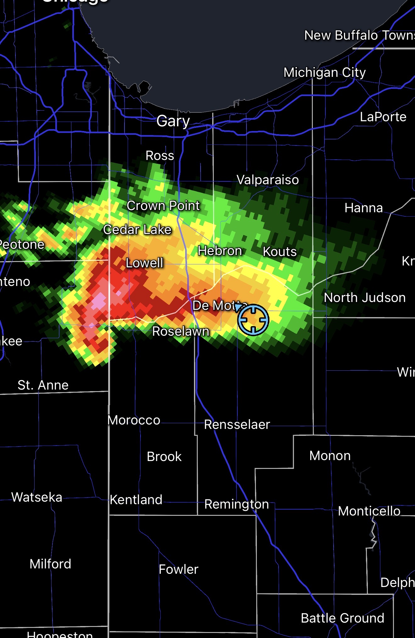
Gonna be close.

-
Yeah the lightning show is incredible.
-
Interestingly we already have sirens going off but not under any warning. Does look like we will at the very least get clipped
-
Already hearing constant rumble from her and nice CC lightning overhead. If it keeps rightward motion, may actually get close.
-
IKK cell will slide north, so locally it looks like we’ll be waiting until later tonight for any action.
-
Lake breeze went through here between 1 and 1:30. Became noticeably more chilly. But now suns out and warming back up nicely.