All Activity
- Past hour
-
I am pleased with our low this morning. If only every morning can have lows in the upper 50s in summer it would be amazing.
-
He dead
-
Records: Highs: EWR: 97 (1943) NYC: 99 (1925) LGA: 96 (1943) JFK: 91 (1971) Lows: EWR: 48 (1964) NYC: 48 (1926) LGA: 51 (2023) JFK: 49 (2023) Historical: 1825 - A hurricane struck Long Island NY leveling trees and causing damage to ships. The early season hurricane, which originated around Cuba, caused major damage along the Atlantic coast from Charleston SC to New York City. Many were lost at sea. (David Ludlum) 1825: A severe storm of tropical origin swept up the Atlantic Coast during the first week of June 1825 with reports of significant damage from Florida to New York City. Shipping logs told of a disturbance at Santo Domingo on May 28th and Cuba on June 1st. Gales were reported at St. Augustine, Florida on the 2nd. The Norfolk and Portsmouth Herald reported "undiminished violence" from the gale force winds for 27 hours, ending on June 4th. The effect of the storm reached well inland. Washington had cold, heavy rain all day on the 4th with high winds laying the crops in the vicinity. The wind also tore up trees by the roots in front of the State House in Philadelphia. This storm impacted the New Jersey Coast and the Long Island area as well with high winds and a two-foot storm surge. A Columbian frigate was driven ashore as were many smaller boats. The largest loss of life occurred along the Long Island shore when a schooner capsized. The entire crew of seven was lost. 1860 - Iowa's Commanche Tornado , with wind speeds estimated in excess of 300 mph, was unquestionably one of the worst experienced by early settlers, with nearly a million dollars damage. (The Weather Channel) 1877: A tornado of estimated F4 intensity touched down just west of Mt. Carmel, Illinois and moved east-northeast, devastating the town. 20 businesses and 100 homes were damaged or destroyed. At least 16 people and as many as 30 were killed, with 100 others injured. 1885: Pittsburgh, PA & Cleveland, OH received up to 10 inches of rain that caused serious flooding. (Ref. Wilson Wx. History) 1892: A rare June snowfall occurred at Cheyenne, WY with 8 inches reported also in 1937 Cheyenne, WY reported 3 inches of snow.(Ref. Wilson Wx. History) 1945: Several locations in the upper Midwest had their coldest June temperatures on record. La Crosse, WI and Waukon, IA dropped to 32°. This was their latest spring freeze and coldest June temperature. Other locations recording their coldest June temperature were Mondovi, WI: 29° and Richland Center, WI: 31°. (Ref. Wilson Wx. History) 1958: An F4 tornado tracked 32 miles through St Croix and Dunn Counties in Wisconsin, killing 20 people and injuring 110 others. (Ref. Wilson Wx. History) 1982 - A four day storm began over New England which produced up to 14 inches of rain in southern Connecticut breaching twenty-three dams and breaking two others. Damage was estimated at more than 276 million dollars. (David Ludlum) 1987 - Early morning thunderstorms in south Texas produced 6.5 inches of rain at Hockheim, and five inches at Hallettsville, in just a few hours. Afternoon thunderstorms in Virginia deluged northern Halifax County with 5.5 inches of rain in two hours. Thunderstorms produced wind gusts to 76 mph at Dusty WA, and wind gusts to 88 mph at Swanquarter NC. (The National Weather Summary) (Storm Data) 1988 - A dozen cities in the eastern U.S. reported record low temp- eratures for the date, including Atlantic City NJ with a reading of 40 degrees. Fifteen cities in the north central U.S. reported record high temperatures for the date, including Glasgow MT and Havre MT with readings of 102 degrees. (The National Weather Summary) 1989 - Thunderstorms produced severe weather from the Southern Plains Region and the Lower Mississippi Valley to the Southern Atlantic Coast Region during the day and into the night. Just four tornadoes were reported, but there were 87 reports of large hail and damaging winds. (The National Weather Summary) (Storm Data) 1993: Lynchburg had 70 mph winds, 95% of city lost power, 21 million damage. Severe thunderstorms were widespread from Missouri and Arkansas eastward to the Mid Atlantic states with more than 260 reports of severe weather, including over two dozen tornadoes. An early morning mesoscale convective complex over southern Missouri and north Arkansas moved eastward and evolved into a vicious derecho, traversing eastward across Kentucky in excess at 80 mph at one point. Wind gusts reached 100 mph near Elizabethtown, KY. Damage was widespread. 30 homes and mobile homes suffered major damage in Butler County. Over 75% of the roads in the county were blocked due to downed trees. 4.5 inch diameter hail fell at Smith Mountain Lake, VA. Total damage from the high winds at hail in Virginia was $60 million dollars, with $21 million of that occurred in the city of Lynchburg. 3.5 inch inch diameter hail was reported in Davie County in North Carolina. (Ref. Wilson Wx. History) 1998: The temperature at Williston, ND dropped to 26° to establish a monthly record for June. Neillsville, WI also reported their coldest June temperature as they dropped to 22°. The mercury dropped to 24° in Tower, MN as winter made one last call across the northern Plains. 2 to 3 inches of snow fell in portions of South Dakota and 7 inches fell in portions of Wyoming. (Ref. Wilson Wx. History)
-
Nice, a dog fighting video. Fuck that and fuck him.
-
You should have been a surgeon instead of poisoning people with your MRNA vaccines
-
It is actually 100x and it has stabilization...but when zooming in, you really need a still hand. This was around 645 this morning.

-
I despise the sound of all powered garden equipment, especially the sound of gas powered blowers.
-
it is claiming tho. heh yesterday we hit the nadir temp at 5:49 am at 45, and by 8 we were 61. today, we nadir at 54 right around that same hour::minute, and by 8 we were 64. so even though we are ahead of yesterday by a couple few clicks, are delta is only 10 vs 16 not having much else to go on .. it seems reasonably that smoke may be playing a mitigating factor. there's also some high clouds being generated/back-building down from the N as the anticyclonic curl is passing over the Greens/White so... bottom line it's a polluted sky. i gotta say ...so far its seems the writing is on the wall for this summer. Earth is going to obsess over finding reasons to always run the temp results along the bottom edge of the what all indicators combined suggests the probability spectrum could be.
-
63 / 55 - warmest day since May 17th or May 2nd for many. Mid - upper 80s, stray chance one of the hot spots in C/NE/N-NJ could touch 90. Some haze / smoke could reduce a degree. Tomorrow first 90s for many in NJ / NJ/NYC metro areas and some of the boroughs. Friday would get there too but clouds and scattered showers / storms look likely. Another cloudy weekend with storms and showers, although the latest forecasts have less focus of rain still think 1 inch is likely. Sunday could clear later in the day but other data has gone to the slower frontal passage the ECM has had most week, cloudy but warmer than the last 2 weekends. Next week 6/9 - 6/13 - near / above normal still rain chances with trough west of us into the GL/MW. Overall warmer look - wetter look into mid month. Heights rise later and pieces of the western heat building over the top and expanding east. GFS continues to try and get some tropical activity in the Gulf. Next shot at 90 degree temps would be in the 6/14-6/17 range.
-
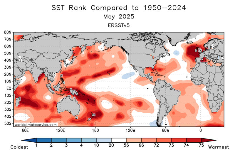
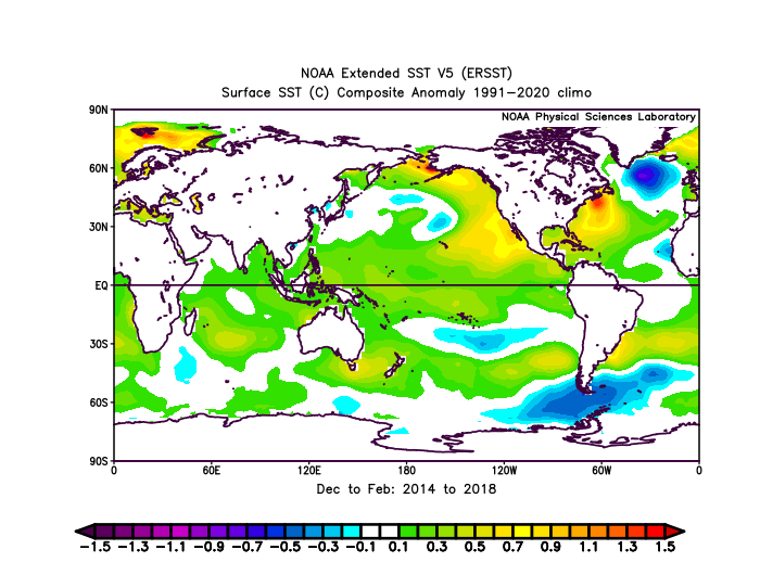
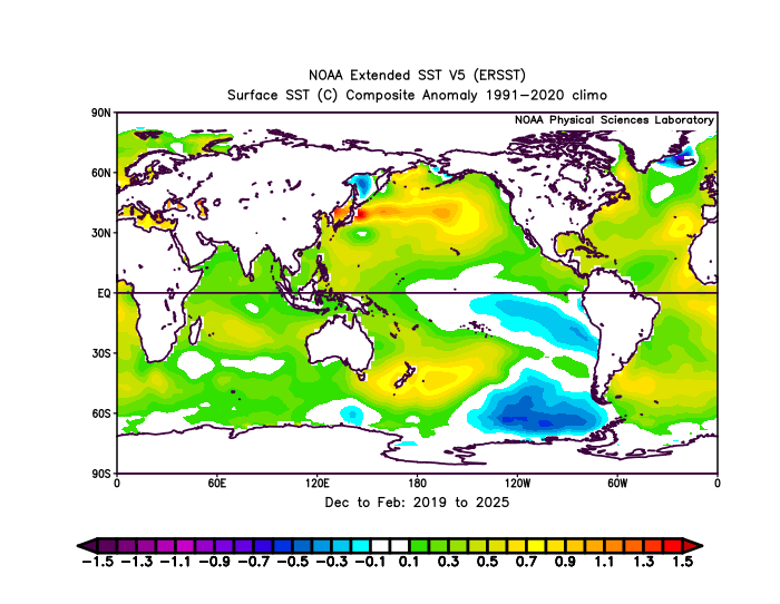
My guess is that the duration of this current -PDO interval, which emerged around 18-19, will linger as long as the WPAC stays this warm. May had multiple areas near and west of the Dateline ranking near the warmest on record. We probably would have continued the +PDO which emerged around 13-14 right into the 2020s if it wasn’t for that rapid increase in WPAC 500mb heights which warmed the WPAC leading to the -PDO. Hopefully, the changes in the WPAC at 500mb and the surface don’t permanently load the dice for more -PDOs with only intermittent +PDOs. In the old days, the -PDO defined more by the cold pool off the West Coast. Now, the warm pool and 2nd EOF of the PDO in the WPAC are running the show. It would be nice to get monthly real time 2nd EOF updates. But the the ranking charts below can be used in place of the formal 2nd EOF numbers. 2019 to 2025 -PDO 2014 to 2018 +PDO
-
no shit... how much is smoking claiming temps - ooh!
-

-
lol what clowns we are. Whatever it’s Wednesday and weather is boring as hell.
-
One of his better songs . Thanks for clarifying your error
-
You think it’s a fucking game??
-
yeah, was asking about this yesterday .. with the HRRR stuff etc ... So far we're ahead of yesterday in T recovery by 4 ( 64 vs 60) by hour::minute. We didn't bottom out quite as deep. 54 here. I realize others came in at or just under 50 but by and large these readings were above the previous night's lows. The higher launch may be skewing/hiding if there is any smoke-induced lag so hard to quantify -
-
He was still listening to RUN DIT in the 90s
-
He fail
-
Still some smoke but bluer sky than yesterday
-
Wrong song. What’s my name
-
Yeah, NJ has done a good job of keeping the heat during the 2020s. The enhanced onshore flow has lead to quite a 90° gradient. The last 5 seasons have averaged 41 days reaching 90 west of the sea breeze front in NJ. Here along the CT Shore we have only been around 12 days. Monthly Number of Days Max Temperature >= 90 for HIGHTSTOWN 2 W, NJ Click column heading to sort ascending, click again to sort descending. Mean 0 1 6 19 12 2 0 41 2024 1 1 11 17 11 0 0 41 2023 0 0 2 18 5 6 0 31 2022 0 3 3 22 19 2 0 49 2021 0 3 10 14 13 1 0 41 2020 0 0 5 23 13 1 0 42 Monthly Number of Days Max Temperature >= 90 for NEW HAVEN TWEED AP, CT Click column heading to sort ascending, click again to sort descending. Mean 0 0 2 5 4 1 0 12 2024 0 0 2 3 4 0 0 9 2023 0 0 0 4 0 4 0 8 2022 0 1 1 6 9 0 0 17 2021 0 0 4 3 5 0 0 12 2020 0 0 1 7 4 0 0 12
-
God, I love June weather dialogue....
-
It’s not one of his better ones.
-
I wish we could get a stretch like New England had in 1780 with the Dark Day
-
I wonder how many people know that song lol.


