All Activity
- Past hour
-
That makes my skin crawl, even though I know we need them lol. Just not inside my house =\
-
Yep, this is the case in many other countries too and it's driving the pollinator mass extinction.
-
JFK ISP batting shut outs for 90 degree days in August. I've had 1 (last Thursday) How is ACY getting shut out of 90 degree days in August, that's very unusual! They might end the month with zero 90 degree days if Sunday doesn't pan out, has that ever happened before?
-
September is still summer and can be quite hot. Our seasons are more closely in line with astronomy than these bogus *Met seasons*
-
Congrats Ant, have you picked a name yet?
-
His new avatar seems to show the Mets are on fire lol
-
Oh wow happed to look outside and it is raining here. Quite the surprise I mean I saw that it was getting a bit darker out but that has happened so many times before I ignored it.
-
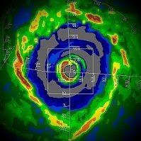
What a beast. That perfect eye on the San Juan radar.
-
You don't even need to get that far into the interior on many of these sea breeze days, I'm a few miles south of Sunrise Highway (but also a few miles north of the ocean), and it often doesn't get here until after 3-4 pm. I'm a little suspicious of 6-7 days of 100+ lol, the summer hasn't been hot enough to do that (1993 and 2010 were wall to wall heat.) Wait, are you sure EWR has had 7 days of 100+ Chris? I thought they only had 4. They're still behind 1949 and 1993 but now it's getting close.
-

Hurricane Erin: 160 MPH - 917mb - W @ 17
Boston Bulldog replied to BarryStantonGBP's topic in Tropical Headquarters
This is trochoidal wobbling of the core, as of right now the eye is deviating back to the NW. The greater motion of the storm is as forecast -

Hurricane Erin: 160 MPH - 917mb - W @ 17
Windspeed replied to BarryStantonGBP's topic in Tropical Headquarters
I mentioned earlier that Erin is embedded in an above mean background pressure regime. So if we get readings down near 910 hPa before Erin levels off, we may see some higher sustained winds yet. We saw this during Dorian and Irma near their peaks, though I'm not saying Erin will get that intense. 150 kts/175 mph sustained doesn't seem unreasonable now, however. -

Hurricane Erin: 160 MPH - 917mb - W @ 17
WxWatcher007 replied to BarryStantonGBP's topic in Tropical Headquarters
-
Unfortunately, I'm not in Queens, I'm in Nassau County so there's no way to do that here, do you know if they are planning on expanding the micronet to Nassau County? Lots of us exceeded JFK's 102 degrees in late June. I remember the sea breeze made it there and then got stuck there before backing off lol.
-
Don could you run the numbers for 1949 and 1944 at NYC too with this new weighting system you're using? They seem like they are very close (1949 is 9th and 1944 is 10th), if you used your new weighting system would 1944 leapfrog over 1949? August 1944 had so many heat records that still stand to this day. It would be interesting to see how summers rank in terms of record highs and let's bring September into the mix. For either NYC or JFK (or both) can summers be ranked in terms of most record daily high temperatures in JJAS?
-

Hurricane Erin: 160 MPH - 917mb - W @ 17
Windspeed replied to BarryStantonGBP's topic in Tropical Headquarters
Wow at that dropsonde from the previous pass, which splashed down in the SW eyewall. -
Hurricane Erin: 160 MPH - 917mb - W @ 17
Eskimo Joe replied to BarryStantonGBP's topic in Tropical Headquarters
So, uh, Erin's on the south side if rhe cone again. -

Hurricane Erin: 160 MPH - 917mb - W @ 17
Boston Bulldog replied to BarryStantonGBP's topic in Tropical Headquarters
While the GFS’s initialization was egregiously high, in a storm with a small intense inner core like this, it will always be playing catchup. Global models simply do not have the granular resolution to initialize a small core correctly, especially in a genuinely extreme RI scenario. Their resolution is far too coarse. Only telescoping models like HAFS have the ability to initialize a storm with Erin’s structure correctly


