All Activity
- Past hour
-
Are you sure?
-
FWIW Norton is watching it: Then early next week will have to monitor the tropics as GFS and ECMWF show a potential tropical system approaching from the south, although GEFS and EPS ensembles keep it well to the south through Tue.
-

September 2025 OBS-Discussion centered NYC subforum
FPizz replied to wdrag's topic in New York City Metro
This was a narrow band of heavy snow. It lead to a normal winter for here while most had a well below average winter. Shows how snow averages can vary widely for parts of areas by decade.
-

September 2025 OBS-Discussion centered NYC subforum
SACRUS replied to wdrag's topic in New York City Metro
-

September 2025 OBS-Discussion centered NYC subforum
LibertyBell replied to wdrag's topic in New York City Metro
Oh that's a good point maybe air pollution from industrial smoke stacks in PA also had an influence. -
September 2025 OBS-Discussion centered NYC subforum
LibertyBell replied to wdrag's topic in New York City Metro
Was this another PD snowstorm that doesn't get talked about much? By the way, I remembered another storm like that, I think it was in January 2022? The one that gave Brooklyn and Queens and points east a foot or more of snow. The wind mostly blew the snow away so I didn't need to shovel at all. -

2025-2026 ENSO
donsutherland1 replied to 40/70 Benchmark's topic in Weather Forecasting and Discussion
Yes, that's correct. I fixed it.. -
September 2025 OBS-Discussion centered NYC subforum
LibertyBell replied to wdrag's topic in New York City Metro
It looks MUCH worse than what we went through a few years ago. Are we sure it wasn't smoke from some mushroom cloud of nuclear testing going on somewhere? -
Hey Don! I think the second chart should be for La Niña and not neutral-cool.
-
September 2025 OBS-Discussion centered NYC subforum
donsutherland1 replied to wdrag's topic in New York City Metro
The preponderance of guidance had it either as a tropical depression or tropical storm. Intensity forecasts this far out aren't very accurate. -
Got a nice storm last night, looked like the heaviest of the system at the time went through here? That's not common nowadays. I don't know how much, though, sorry, because I live in an apartment, so I don't have a rain gauge. Raindrop.farm (if that's reliable?) says 0.61. Hoping for more! The humidity is so awful, though, I couldn't sleep well last night.
-

September 2025 OBS-Discussion centered NYC subforum
Sundog replied to wdrag's topic in New York City Metro
Ah yes my favorite event of that year I think LGA had like 40:1 ratios in the 2004 event. -
September 2025 OBS-Discussion centered NYC subforum
LibertyBell replied to wdrag's topic in New York City Metro
Interesting news stories from 1950 lol, I take it the Korean war was ongoing? -
September 2025 OBS-Discussion centered NYC subforum
LibertyBell replied to wdrag's topic in New York City Metro
Even 49/40 at Pittsburgh! Are we sure wildfires in Western Canada caused all this? It looks like night time in the middle of the day.... -

September 2025 OBS-Discussion centered NYC subforum
TheClimateChanger replied to wdrag's topic in New York City Metro
Well, I think it was wildfire smoke, but it wasn't without some questions. Sounds like the thought of wildfire smoke from Canada causing such an obstruction to the sky was just unthinkable in 1950, if they had only been around these days, it's no big deal anymore. -
September 2025 OBS-Discussion centered NYC subforum
FPizz replied to wdrag's topic in New York City Metro
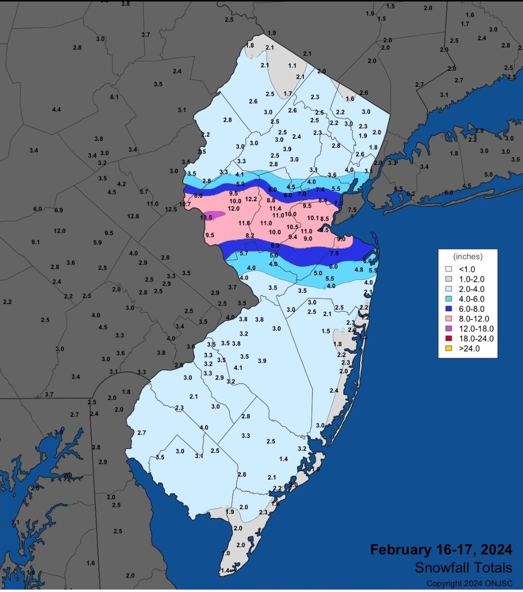
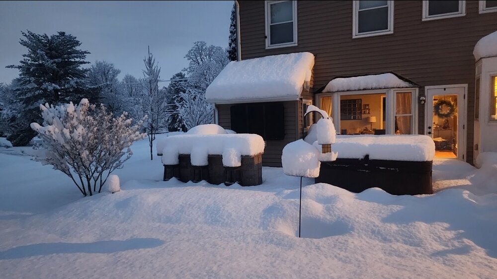
Feb 16-17 2024, the foot of snow we got here was like that. Ratios were 20 to 30:1 -
September 2025 OBS-Discussion centered NYC subforum
Sundog replied to wdrag's topic in New York City Metro
If not wildfire smoke then what would it be? -
September 2025 OBS-Discussion centered NYC subforum
TheClimateChanger replied to wdrag's topic in New York City Metro
They claim the smoke was at 15,000 to 20,000 above the ground, so probably minimal impact. But the AQI would have been horrible back then just from industry most likely. -
Been on the regional spinner threat for days now for tomorrow
-
September 2025 OBS-Discussion centered NYC subforum
LibertyBell replied to wdrag's topic in New York City Metro
Thanks, I'd love to see some pictures from this, I wonder what the AQI would have been? -
September 2025 OBS-Discussion centered NYC subforum
TheClimateChanger replied to wdrag's topic in New York City Metro
Well, that was the official explanation, but it would seem even some Weather Bureau meteorologists were a little skeptical of that explanation: "The most noteworthy feature was the unusual darkness from 2 to 4 p.m. on the 24th, allegedly caused by a heavy smoke layer brought by north-west winds from Canadian forest fires..." -
I lived in Providence for ten years (2000 - 2010). Congrats to my friends and family down there!
-
I don't do tropical seasonal calls. Show me the forcast that called for a hyper active season....JB maybe? I guess there is an inherent level of subjetivity at play with respec to what one considers "very" active, but to me, this isn't it. Forecast for 2025 Hurricane Activity Forecast Parameters CSU Forecast for 2025* Average for 1991-2020 *CSU released its first seasonal forecast for 2025 on Thursday, April 3th, with updated forecasts on June 11, July 9th, and Aug 6. Named Storms 16 14.4 Named Storm Days 80 69.4 Hurricanes 8 7.2 Hurricane Days 30 27.0 Major Hurricanes 3 3.2 Major Hurricane Days 8 7.4 Accumulated Cyclone Energy (ACE)+ 140 123 ACE West of 60 degrees longitude 87 73
-
We got .25 in about a half hour, most of it. Damp and warm, humid, not bad here this morning!
-

September 2025 OBS-Discussion centered NYC subforum
Brian5671 replied to wdrag's topic in New York City Metro
We do need the rain-just bone dry last 3-4 months