All Activity
- Past hour
-
It's looks like another below normal day in the books. 9 in a row! I remember the AHATT folks saying it was a brief cooldown. Lolz!
-
He was a cut-up ol' Dwight. Seem to remember seeing that on the 8-in philco.
-
Peaked at 92° at ORD and 93° at MDW today. ...2025 90°+ Day Tally... 24 - ORD 24 - MDW 24 - DPA 23 - PWK 22 - ARR 19 - RFD 19 - LOT 14 - UGN
-
I think there is a photo of Eisenhower pointing a map showing Carol hitting North Dakota.
-
Total bullshit
-
My analysis had nothing to do with date of formation. It was strictly based on date of Conus landfalls.
-
 Highs: PHL: 85 TEB: 83 EWR: 82 NYC: 82 New Brnswck: 81 LGA: 81 TTN: 81 ISP: 80 ACY: 79 JFK: 79 * missing the intra hour highs BLM: 77
 -
Meanwhile back on earth, 70/52 you couldn't draw it up any better. Again! What a stretch!
-
Still no Beavers? Signed a guy off the street to play tonight in Baltimore. Lol. Wtf
-
I'd be happy with a miss like that - 5-10" of rain and gusty NE to NW winds
-
aaaaand that's a miss for us
-
I won't be needing this anymore.


-
way way OTS
-
-

2025 Atlantic Hurricane Season
BarryStantonGBP replied to BarryStantonGBP's topic in Tropical Headquarters
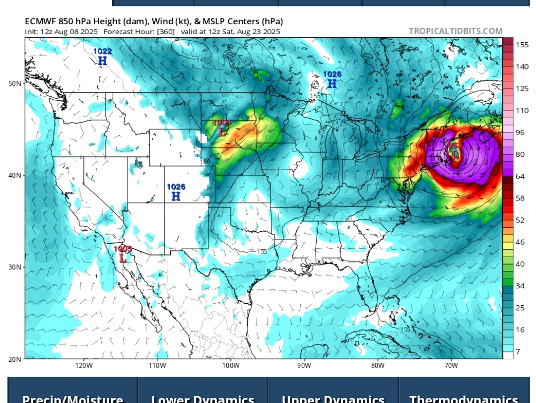
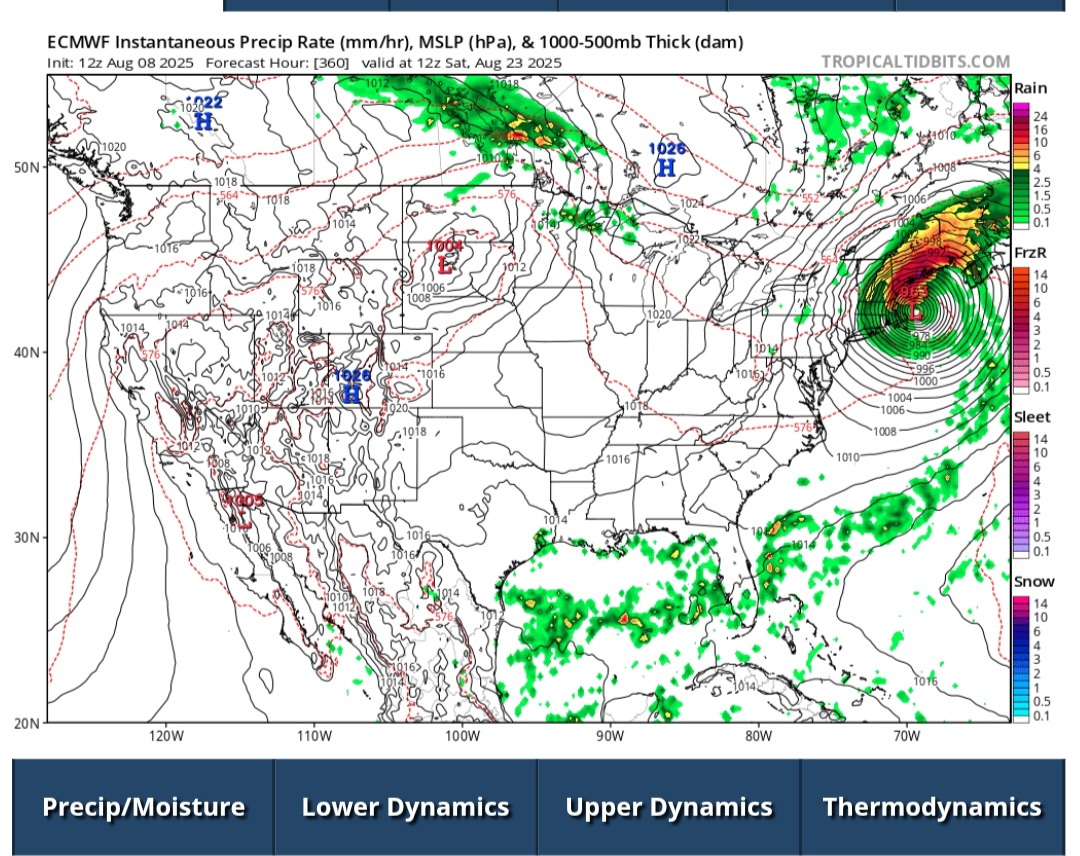
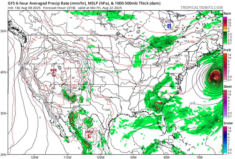
OT but I'm fucking laughing at the fact the phase 7 formation was a fucking 110kts major hurricane in this example A fucking 110kts major hurricane how the fuck does this happen
- Yesterday
-
oh okay i see gotcha kdxken thanks
-
No need to be sorry. He's hard to decipher.
-

SE Area of Interest--10% two day, 20% five day odds
WxWatcher007 replied to WxWatcher007's topic in Tropical Headquarters
This might be one of the very worst forecasts I’ve ever attempted -
sorry for any of the confusion i got mixed up with what was said in here i saw damaged in tolland said daniel san and so i looked it up and saw it was in reference to the guy who was in the movie the karate kid so i said that because i thought he was talking about my profile picture
-
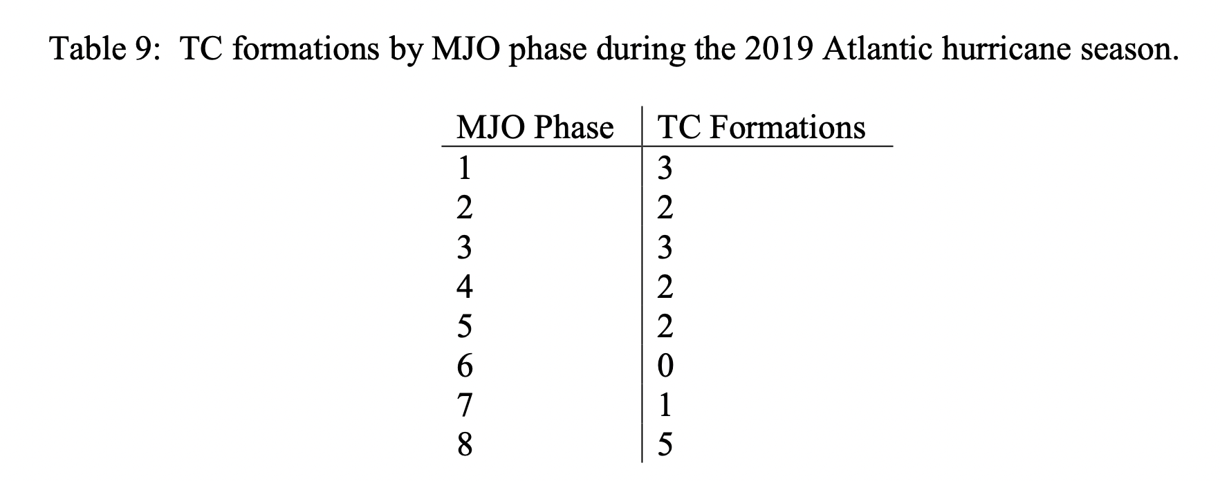
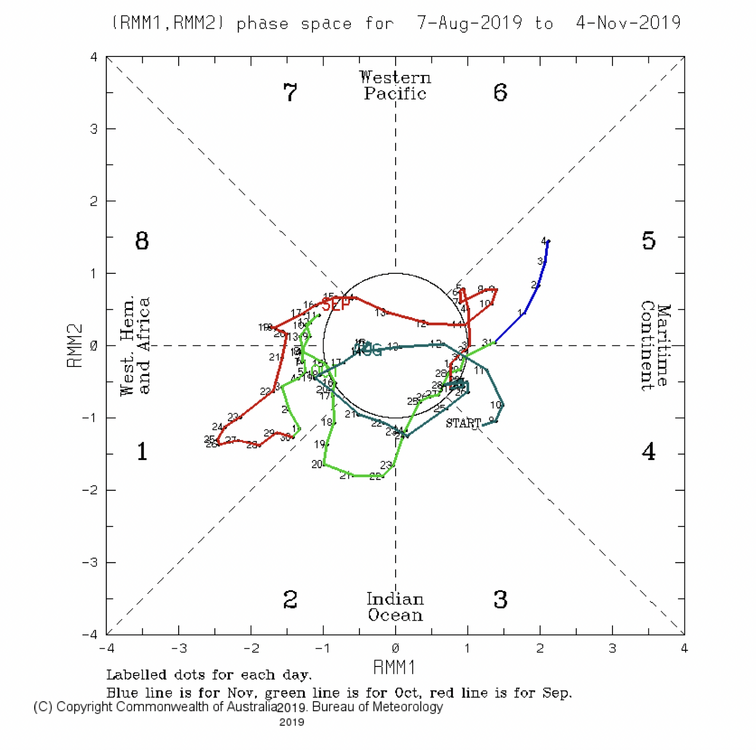
MJO phase (whether inside or outside the circle) 1975-2024 Jul-Sep on day of 67 CONUS hurricane hits 1: 7 (10%) 2: 17 (25%) 3: 7 (10%) 4: 7 (10%) 5: 10 (15%) 6: 6 (9%) 7: 2 (3%) 8: 11 (16%) ——————— MJO phase (whether inside or outside the circle) 1975-2024 Jul-Sep on day of 23 CONUS MAJOR hurricane hits 1: 3 (13%) 2: 9 (39%) 3: 2 (9%) 4: 2 (9%) 5: 2 (9%) 6: 2 (9%) 7: 0 (0%) 8: 3 (13%) Analysis: Whether considering all US H hits or just MH hits, phase 2 has easily had the most hits of any one phase. You may wonder (and I wondered at first, myself) if that’s because there were far more days in phase 2 than any other phase during Jul-Sep 1975-2924. Answer: 16.8% or 1 in 6. So, it had somewhat more than an avg share, which is 12.5%. But that’s not nearly enough to fully explain the high phase 2 #s. Conclusion: So, phase 2 really has had by a good margin the highest frequency of H and especially MH CONUS hits per days in that phase during Jul-Sep since 1975. Sources: I looked at the following sources and did the calculations: 1. MJO phase: http://www.bom.gov.au/clim_data/IDCKGEM000/rmm.74toRealtime.txt 2. H classification/hit dates: NHC archives 3. For Katrina and Ian, I counted only the day of the more intense hit to determine MJO phase. For Andrew, both hits were during phase 6.
-
No. Anywhere from Atlantic Canada to the Mexican Gulf coast should be on alert for this potential storm that hasn't even splashed down from Africa yet. No one location should be on any higher alert than another.
-
I’m on my second Vantage Vue. I didn’t realize they had come out with a new touchscreen model.
-
huh im not sure what you mean
-
SE Area of Interest--10% two day, 20% five day odds
BarryStantonGBP replied to WxWatcher007's topic in Tropical Headquarters
L 1. Western Atlantic: A large area of disorganized shower activity off the coast of North Carolina and the Mid-Atlantic States are associated with a non-tropical low pressure system. This system is expected to merge with a front and move over cool waters this weekend, and tropical or subtropical development is not expected. * Formation chance through 48 hours...low...near 0 percent. * Formation chance through 7 days...low...near 0 percent.