All Activity
- Past hour
-

Winter 2025-26 Medium/Long Range Discussion
HillsdaleMIWeather replied to michsnowfreak's topic in Lakes/Ohio Valley
Euro also has pretty widespread freezing rain up to the border, definitely something to watch -
Would've loved to see more of the 0z Euro... but it almost alludes to what BAM said regarding the big storm for the first week of January.
-

E PA/NJ/DE Winter 2025-26 Obs/Discussion
LVblizzard replied to LVblizzard's topic in Philadelphia Region
0z models are looking VERY interesting for Friday-Saturday. If that blocking trends just a little stronger some of us could be in for a pretty significant snow or ice storm. -

Winter 2025-26 Medium/Long Range Discussion
SouthOaklandCtyWX replied to michsnowfreak's topic in Lakes/Ohio Valley
The cutoff between 6+ inches of snow and nothing is pretty sharp too. -
yes and since its multiple models trending that way and its only 5 days away chances are good we will have at least some sort of frozen event - still way too early for details..........
-
0z Euro and GFS are advertising some ZR for our northern crew on 12/26-27. It has ticked south a lot over the last 24 hours... maybe they can tick again?
-
Yep. Now the eps is also south. Looks like the models latched on to the blocking tonight.
-
agreed and its only 5 days away....
-
Its further south like the other models. Good trends tonight.
-
The problem with the Euro is that HP in Canada is not holding in place compared to the GFS - the LP is allowed to move further north
-
Winter 2025-26 Medium/Long Range Discussion
HillsdaleMIWeather replied to michsnowfreak's topic in Lakes/Ohio Valley
0Z GFS is wanting to utterly nuke Grand Rapids to Detroit with an ice storm the day after Christmas -
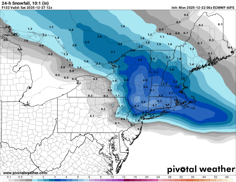
Several inches This is getting interesting
-
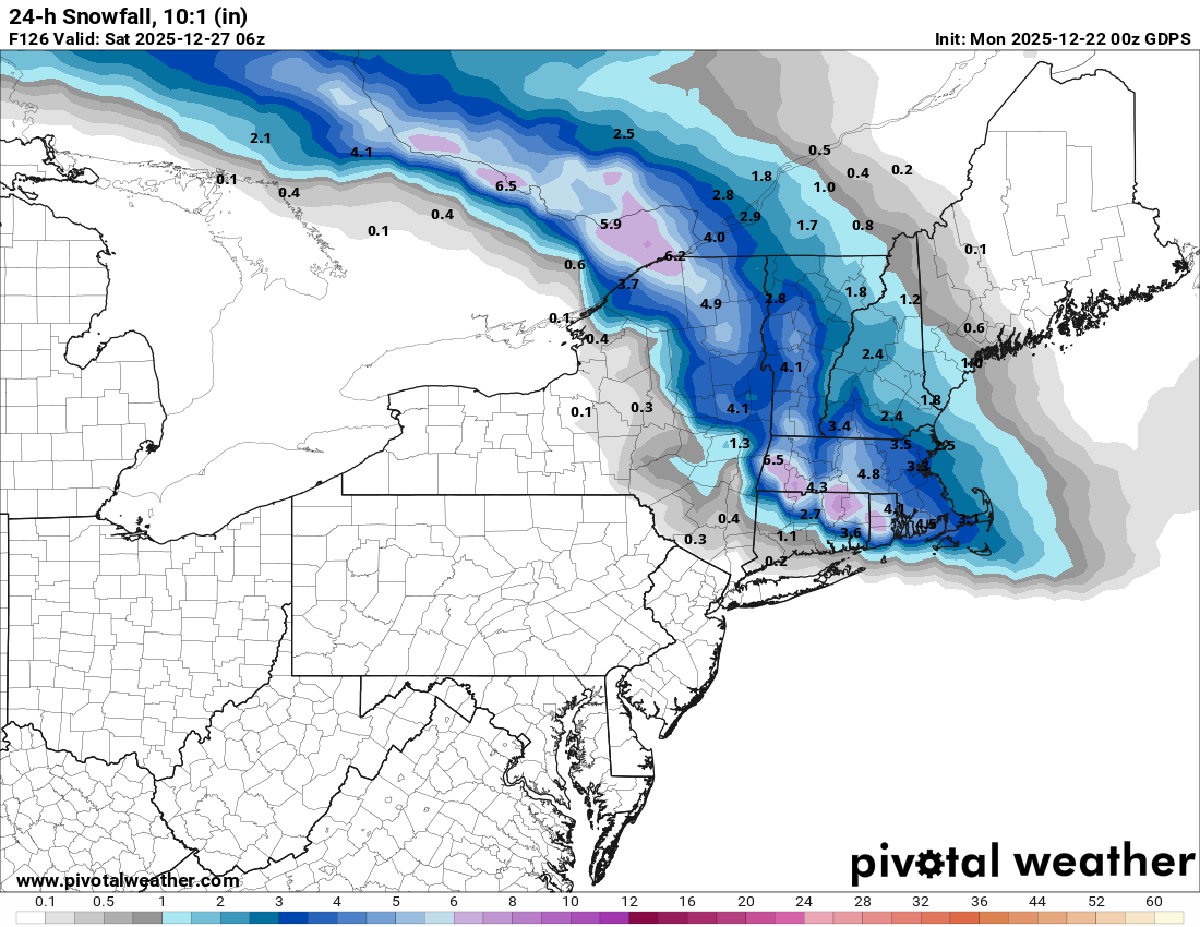
have a snow map?
-
That’s not just a cold shot though. That’s a 500mb map with a clear trend toward a stronger, more west based ridge (+PNA) and a trough forming in the east. Block is establishing etc. That being said… still very far out so it’ll change 50x. Grain of salt yada yada
-
Euro !
-
Euro south


- Today
-
AI euro is south for next week
-
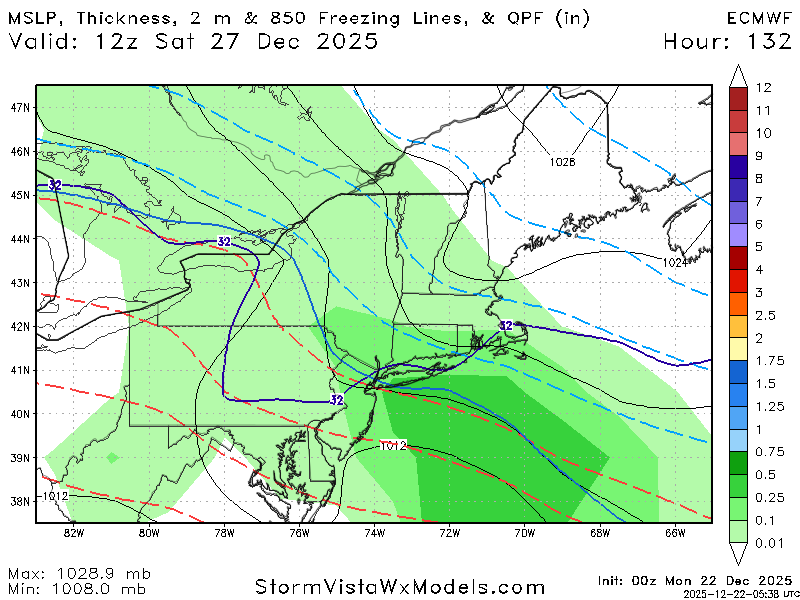
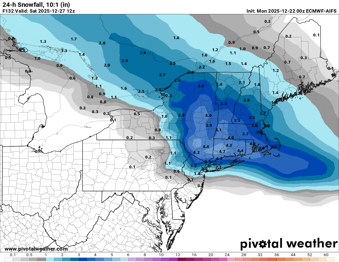
00z ecmwf ai is also south snow to rain.
-
IF's And's or But's -all involving where that HP is in southeast Canada and the strength of it throughout the event- pattern is changing back into a colder one along with more blocking developing
-
.thumb.png.4150b06c63a21f61052e47a612bf1818.png)
December 2025 regional war/obs/disco thread
HIPPYVALLEY replied to Torch Tiger's topic in New England
Those totals will shift around a bunch this week but good to see something on most models. -
I think it's fair to say that in the last 24 hours this potential storm has become more interesting and that if trends continued it could open up the possibility of a mostly frozen or even a mostly snow event Friday. But there's a lot of *ifs* there. WX/PT
-
May be the beginning of models moving toward analogs
-
Gefs also shifted well south of 18z. Ukie also shifted south. Nothing like the gfs as of right now.
-
.thumb.png.ad95a2f1a7b6fc730f4903f5699d9b79.png)

-
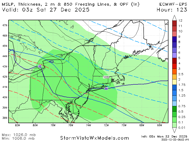
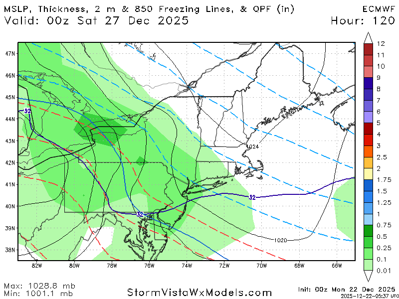
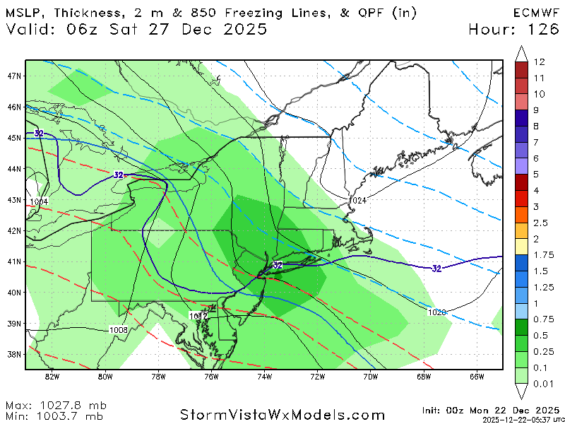
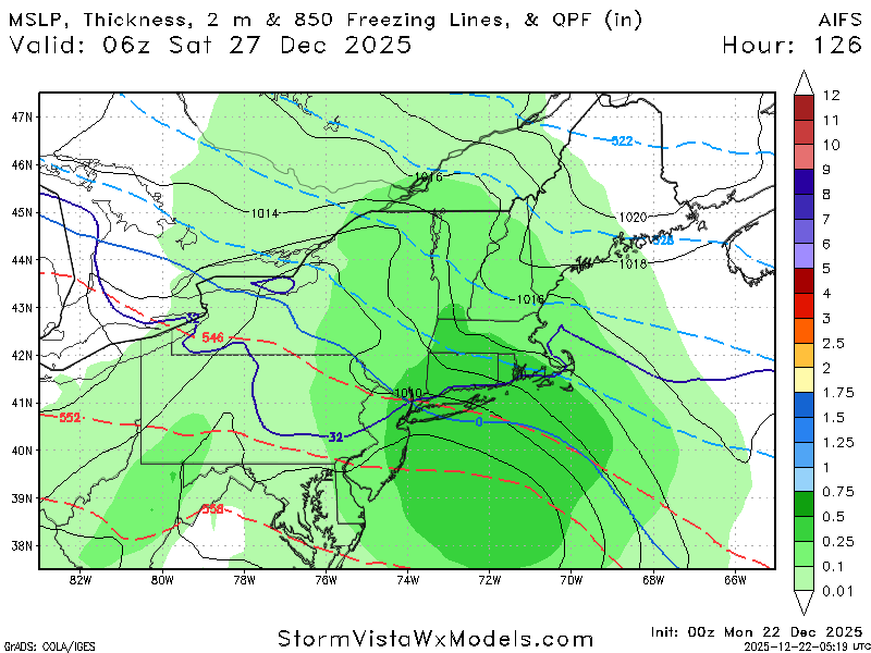
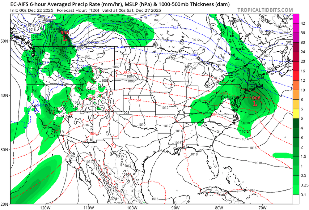
Operational GFS is mostly snow for that event and a good amount of it. It shows a more suppressed storm track primary low dies over the Appalachians and re-develops well offshore east of Delmarva Peninsula. We'll see this change more than a few times over the next 3 days. I think it's worth watching. 18Z Euro AI had storm track right over us with nothing but rain. WX/PT


.png.2aa504b947a898267c6ab426c4eb59bf.png)