All Activity
- Past hour
-
Deep summer today? Maybe the hazy look..but its also like 75/54 here. Tomorrow should be closer
-

2025 Atlantic Hurricane Season
Stormchaserchuck1 replied to BarryStantonGBP's topic in Tropical Headquarters
ACE is probably a better metric. Either way, there is a clear SLP pattern of Atlantic tripole for active seasons Apr-May vs the opposite. We've had a little more +NAO/+AO this Apr-May. -
We are locked and loaded for quite sometime kid . We sweat
-
All this MCS activity and convection along the front is causing some major model chaos. Part of the issue too is the degree of convection is so extensive that this will cause some big wiggles in the placement of the boundary throughout the day today and tomorrow. So it may seem at times the front is farther south and east that modeled, but as convection wanes a bit in the overnight the front position corrects back northwest a bit. Makes it very challenging on what to expect here in terms of frontal timing and placement.
-
2025-2026 ENSO
Stormchaserchuck1 replied to 40/70 Benchmark's topic in Weather Forecasting and Discussion
That's the way I'm leaning too, but it wouldn't surprise me if the decadal started moving less positive 1st month in out of 4.. and the N. Atlantic SST index is slightly negative right now. Like -0.3 -
LOL, I know that is true. Although we had an event in late May 2004 (at least locally) under sunny skies and light NE flow with some great aftn SVR. Mostly hail, but I was shocked. But I get it...typically does happen. GFS has the boundary a bit more to the north, but the GFS won't resolve the NNE leakage too.
-
“Only” 76 at home at noon. Smoke cutting temps a bit?
-
2025-2026 ENSO
Stormchaserchuck1 replied to 40/70 Benchmark's topic in Weather Forecasting and Discussion
It looks like Apr to May this is the 3rd biggest move since 1948. The other two were trending negative to positive.. all 4 biggest moves since 2014. 1. 2024 -23.42 -6.52 2. 2015 -24.38 -12.33 3. 2025 6.94 -4.59 4. 2014 7.15 -2.81 -
Thanks. That shower here late last night was just a quick, isolated rain. But late this morning it has been much more widespread in SE GA.
-
mm kinda (personally) don't wanna see that nam set up. If we lift mu caped air over a boundary ... regardless of kind, it fuzzes out into a putrid warm rain with embedded orange flickers and distant thunder
-
2025-2026 ENSO
Stormchaserchuck1 replied to 40/70 Benchmark's topic in Weather Forecasting and Discussion
We had a G4 solar storm 2 days ago, and G3 the day before that. This Winter is probably going to be another good data point for high solar. -
That stuff makes me real nervous. I get real paranoid when being outside when thunderstorms start getting within a certain distance. That is one thing I think that would freak me out most about chasing in the Plains...at least here there is a good chance there are taller objects around you, but out there you are the tallest object
-
Had a nasty bolt from the blue last year under clear skies, but caught a house on fire down the street. Storm was probably 5-6 miles north. That scared the shit out of me.
-
81 here
-
For Friday? Yeah certainly could be more CT/RI focused. But there is decent MU CAPE to the north..so I could see it being a little elevated which means maybe a bit more north than the srfc front would argue. But, not worth being picky....just discussing.
-
Lock in CEF/Holyoke flood.
-
Could be those pulse type with lots of CGs and probably even some of those nasty +CGs.
-
exc Except that the NAM's grid indicates a convective induced frontal sag through the region with under cutting N-NE cooled air... It's all probably just NAM fantasy at this range, but if suppose it had legs ... it's pretty clear in the FOUS that day's SB CAPE is shit smeared. It's also now losing the low transit through NNE so it's going after Saturday too.
-
I'm really hoping to get something out of this...even if non-severe. I am off this week and next week for my friend and I's annual get together for local chasing. One of these years we'll do out west but my energy levels are fading and I'm so tired of driving so who knows
-
I see what Wizzy is seeing on the NAM. There is a psuedo EML tickling S coast and decent CAPE near and SoP. Despite limited shear, forcing looks to be along wavering from near pike. So yeah...a few storms could be interesting.
-
Heat comes right back for sweaty COC.
-
Assuming the 12z GFS is correct. A big assumption right now - but that has a great look for strong/severe Sunday afternoon.
-

2025-2026 ENSO
40/70 Benchmark replied to 40/70 Benchmark's topic in Weather Forecasting and Discussion
You mean the QBO is oscillating back and forth from westerly to easterly...must be CC!! JK -
Red hot news bulletin (followup): Not at all surprisingly based on past patterns, the 30 mb QBO dropped to negative in May (-4.59) from April’s +6.94: https://psl.noaa.gov/data/correlation/qbo.data
-
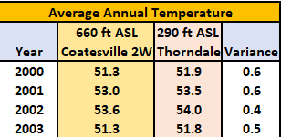
 Your problem is you have zero proof any of those moves required a 2 to 4 degree temperature adjustment which is what took place. As a simple example (small sample size but enough to be clearly directional) I have analyzed the difference between the relatively rural Coatesville 2W at 660 ft ASL vs Thorndale 290 feet above sea level and in the middle of a sprawling development but only a few nautical miles apart. Even a move from the relatively rural Coatesville 2W to an suburban sprawl development at almost 400 ft asl lower does not result in anywhere close to the magnitude of changes the NCEI tries to apply.