All Activity
- Past hour
-

Jan 30th-February 1st 2026 Arctic Blast/ULL Snow OBS Thread.
zbrown89 replied to John1122's topic in Tennessee Valley
Ty appreciate it . -

The “I bring the mojo” Jan 30-Feb 1 potential winter storm
Silver Meteor replied to lilj4425's topic in Southeastern States
Weather Balloons / Government Isn't The Only Solution https://windbornesystems.com/products/observations -
I’m sorry but did GSP use the word blizzard? I’m east of northeast Georgia and west of that triangle area. Ugh. Hoping the band forms further west than the models have progged.
-
The “I bring the mojo” Jan 30-Feb 1 potential winter storm
Berlin1926 replied to lilj4425's topic in Southeastern States
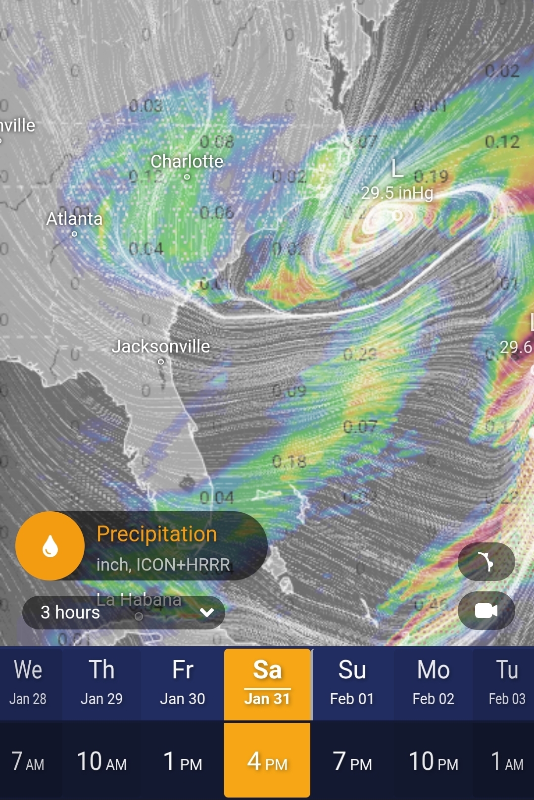
Cool tool. Here it is at 4p.
-

Jan 30th-February 1st 2026 Arctic Blast/ULL Snow OBS Thread.
Stovepipe replied to John1122's topic in Tennessee Valley
The super heavy dbz stuff looks to have wobbled over to west Knox, Loudon, and NW Blount. The overall blob is growing towards Madisonville and Tellico Plains. Oscillating between periods of peas with dimes and dimes with nickles here. Pretty dang good rates even when the radar shows relatively lower. -

January 30th- Feb 1st ULL and coastal storm obs
Jmoon replied to JoshM's topic in Southeastern States
Light snow here to. Starting to ramp up. -
It's on now brother!!!
-

Jan 30th-February 1st 2026 Arctic Blast/ULL Snow OBS Thread.
bearman replied to John1122's topic in Tennessee Valley
If you are wondering if there is really mixture there, no there is not. I am not sure how the tech is supposed to work and determine what is falling, but it is not real accurate. -
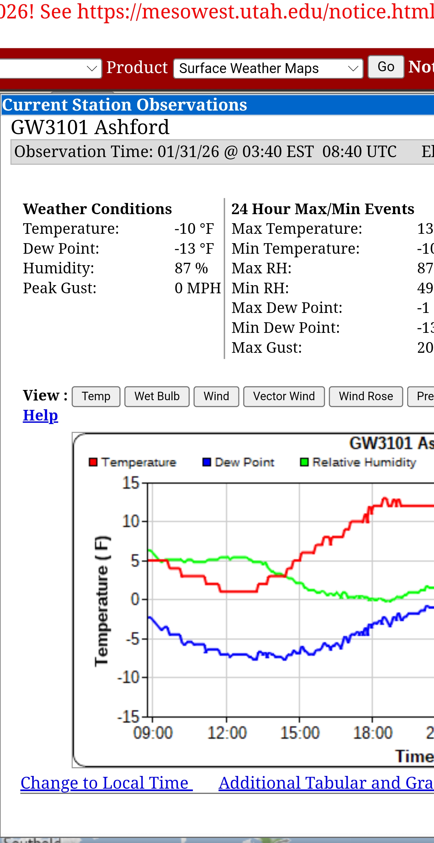
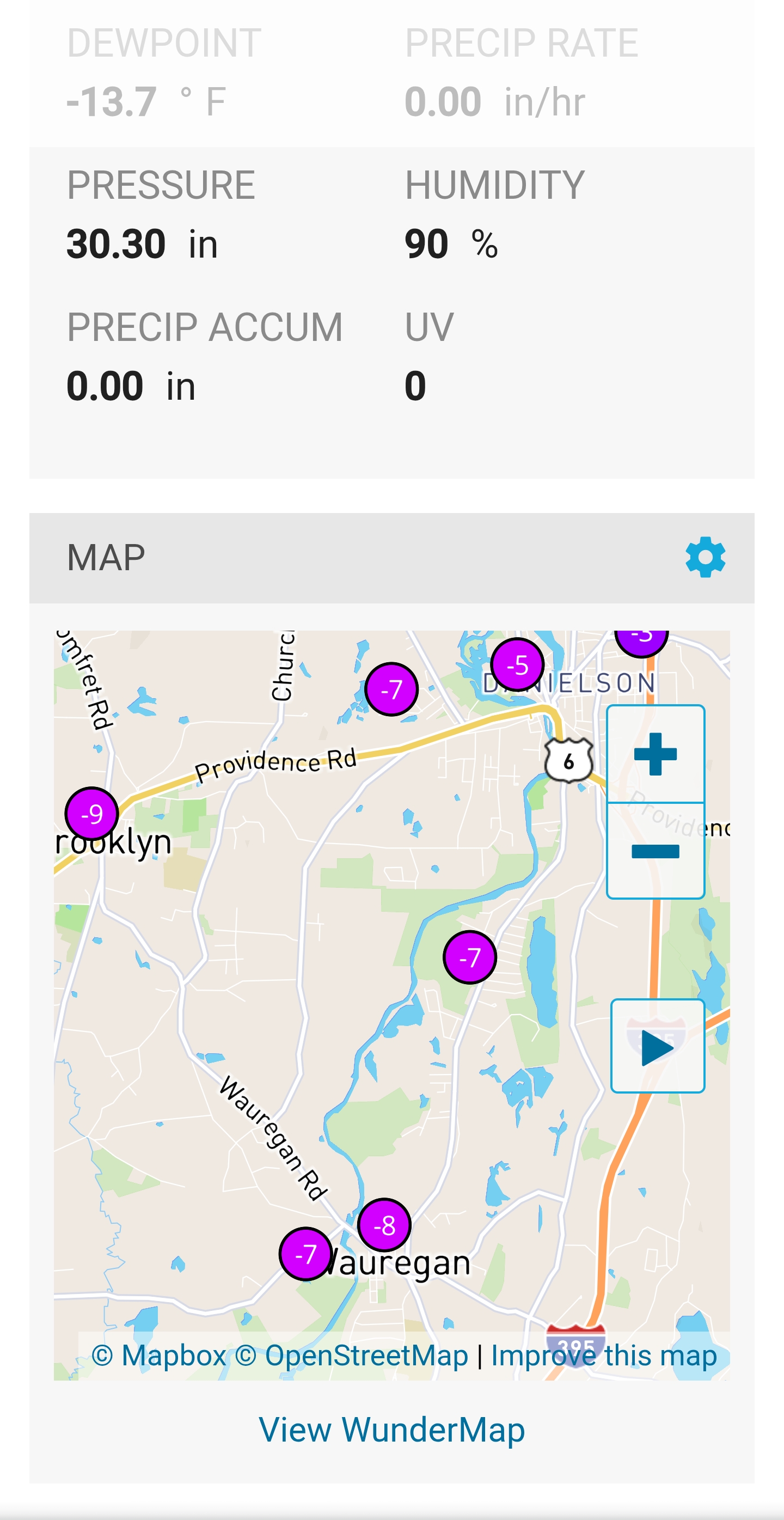
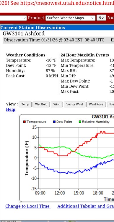
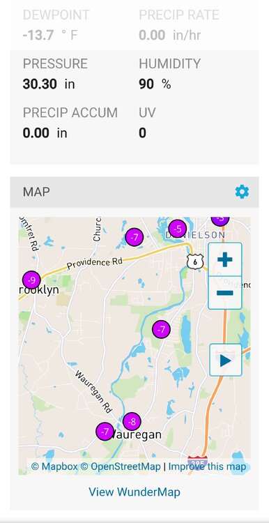
Man valley decoupled.Colder at IJD -8 Belchertown-8 Asford CT-11 than NNE
-
Area Forecast Discussion National Weather Service Greenville-Spartanburg SC 116 AM EST Sat Jan 31 2026 The CAMs continue to suggest banded structures in the simulated reflectivity though this might not be a strong case for mesoscale banding. If that were to develop, there could be sharp stripes and gradients of snowfall. Either way, there will probably be at least one axis of heavier precip/snow where the better frontogenesis sets up on the north side of the 850 mb low. What is interesting is how several guidance sources want to place the best snow potential somewhere out in that triangle area bounded by GSP/CLT/CAE later today. Guidance also has been consistent with a stripe of better snow potential somewhere in northeast GA, but confidence in placement will be elusive until/unless we see it start to materialize. Note that if we have banding, some places will get less than expected. However, the air mass should be cold enough...generally in the low/mid 20s outside the mtns...and the rates high enough...upwards of 1/2 to 1 inch per hour...that even lower accums will result in significant challenges to transportation as the snow easily sticks to roadways. There could also be some blowing snow concerns through the event that could result in brief near-blizzard conditions in some spots, particularly during the daylight hours.
-

Possible coastal storm centered on Feb 1 2026.
ineedsnow replied to Typhoon Tip's topic in New England
6z NAM gets the cape good again -

January 30th- Feb 1st ULL and coastal storm obs
JoshM replied to JoshM's topic in Southeastern States
Flurries flying, 28.8/15.6 -

January 30th- Feb 1st ULL and coastal storm obs
strongwxnc replied to JoshM's topic in Southeastern States
Lets go! -
January 30th- Feb 1st ULL and coastal storm obs
strongwxnc replied to JoshM's topic in Southeastern States
27/18 light snow! -
Its ripping in boone per the cccti watauga campus cam .
-
Uppped totals. Good to see as I get up I thought a decrese.
-
January 30th- Feb 1st ULL and coastal storm obs
NCBlizzard replied to JoshM's topic in Southeastern States
Flurries have started off and on in Belmont. 29° -
Jan 30th-February 1st 2026 Arctic Blast/ULL Snow OBS Thread.
zbrown89 replied to John1122's topic in Tennessee Valley
Not gonna lie been a long time lurker and this is my first time posting but it is 26.2 degrees here in north Ringgold…I could be way off but this is odd to me and I am curious to learn about this radar imaging. Thanks for your patience and time. . -
Area Forecast Discussion National Weather Service Greenville-Spartanburg SC 116 AM EST Sat Jan 31 2026 .WHAT HAS CHANGED... Snow amounts have been bumped up slightly across the region, mainly over the NC Foothills, but most places very similar to the previous fcst. LETS GO. Flakes. I just woke up!
-
Jan 30th-February 1st 2026 Arctic Blast/ULL Snow OBS Thread.
Stovepipe replied to John1122's topic in Tennessee Valley
HRRR still good through 2pm for snow in most areas and some far longer than that in the east. Showing a 4 to 7 inch gradient over Knox still! I'm likely between 3 and 4 currently at 19.6 degrees. We reeled us in a good one! -

January 30th- Feb 1st ULL and coastal storm obs
WiseWeather replied to JoshM's topic in Southeastern States
It is ripping in boone per the cccti watauga campus web cam . -

The “I bring the mojo” Jan 30-Feb 1 potential winter storm
Jimbo! replied to lilj4425's topic in Southeastern States
Haven’t measured but it sure looks like we’ve got at least that here in Danville. Plows running on the mains and lots of powder all over the neighborhood. . -

Jan 30th-February 1st 2026 Arctic Blast/ULL Snow OBS Thread.
John1122 replied to John1122's topic in Tennessee Valley
I'm down to 14 degrees and it's back to absolutely pouring down again. Vis around 1/4th mile. The radar doesn't even look impressive but even seeing returns at all on the Plateau when the DGZ is almost to the surface, is impressive. -

January 30th- Feb 1st ULL and coastal storm obs
WXNewton replied to JoshM's topic in Southeastern States
Light snow in Newton. 28.1/14.3 -

January 30th- Feb 1st ULL and coastal storm obs
tgarren replied to JoshM's topic in Southeastern States
Light snow in Asheboro, NC