All Activity
- Past hour
-

Junorch obs and discussion 2026
Damage In Tolland replied to Damage In Tolland's topic in New England
Can’t even drop fertilizer with no rains -
It'a not a bad setup. Dews increase, decent s/w, 500 temps cool late day.
-
yeah, that's a good point. I've come to think based on experience that mlv lapse rate may be our most important metric up here in NE. Maybe orographic forcing offsets some
-
Junorch obs and discussion 2026
Damage In Tolland replied to Damage In Tolland's topic in New England
Stein pattern now -

2026-2027 Strong/Super El Nino
GaWx replied to Stormchaserchuck1's topic in Weather Forecasting and Discussion
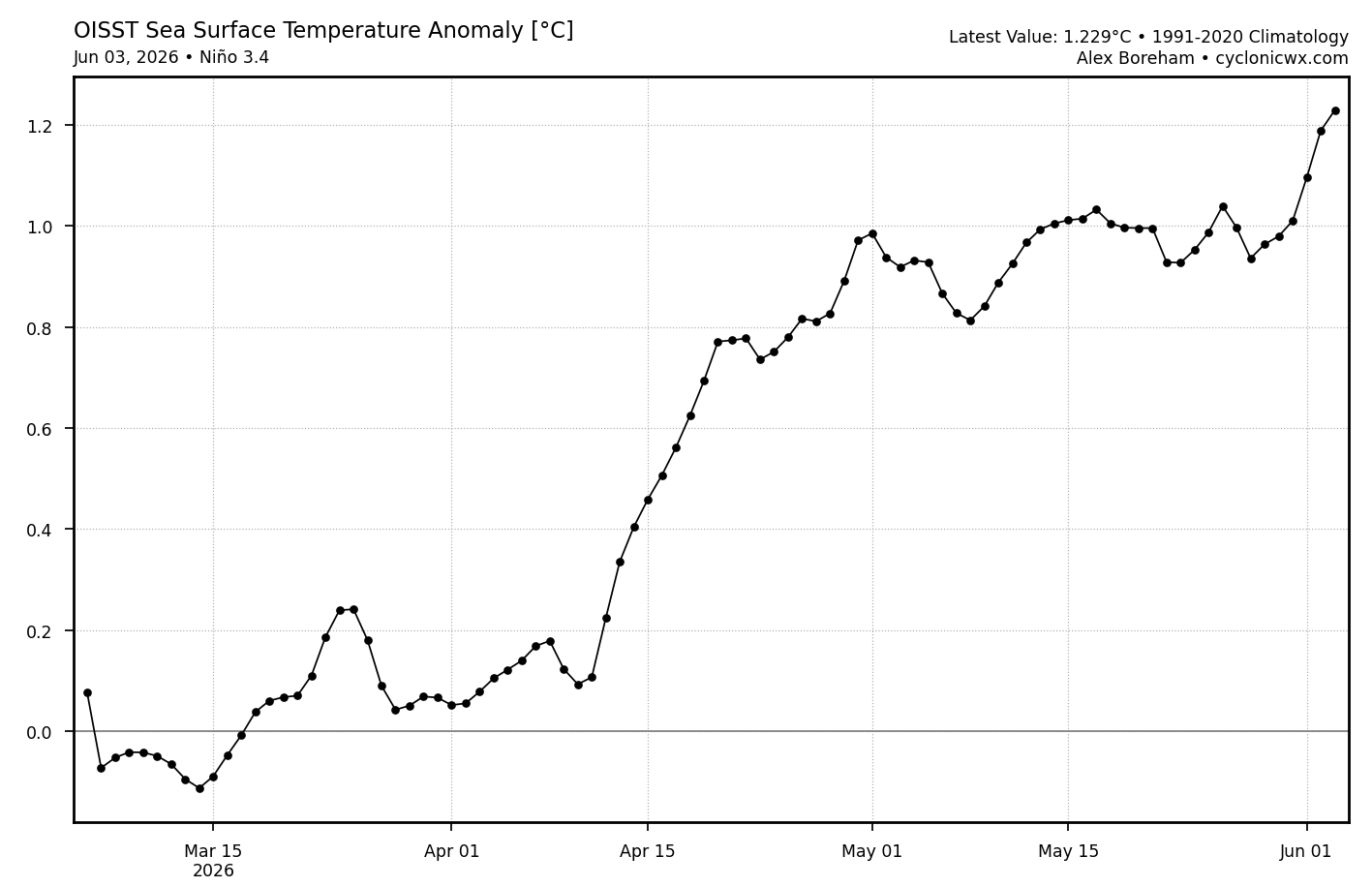
Today’s OISST update (for June 3rd) doesn’t have the dramatic 0.9C rise of each of the last 2 days, but it still rose 0.4C to +1.229C.The implied RONI equivalent is ~+0.7C: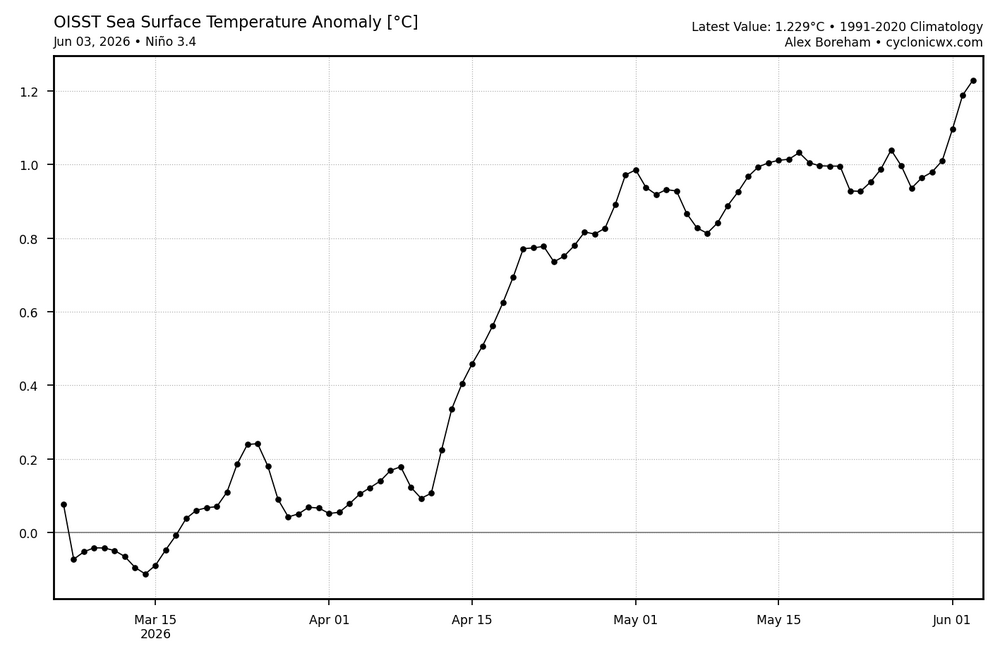
-
Some of the models tried getting some better lapse rates in here late Saturday. Obviously that’s probably more of a now cast thing, but could give a little boost to storms if we can get sufficient mid level lapse rates.
-

2026-2027 Strong/Super El Nino
LakePaste25 replied to Stormchaserchuck1's topic in Weather Forecasting and Discussion
I agree, but verbatim the model run posted is not a classic +PNA/-EPO look that we tend to see in weaker Ninos. There may be periods of it, however which could be factored in the ensemble mean. I just wouldn’t take those blues in the South as “winter-like cold that supports snowfall most of the month.”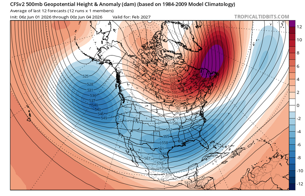
-
Still touring at his finest...it's David Lee Roth! Don't think he sold out the Keswick last time around. Man, drugs hit him hard for only being 71 and borderline mental....looks 80ish.

-
I will give you this much ... waaaaay back when the dinosaurs ruled there was this model called the ETA. It's the ancient ancestral root of the present era's NAM species.... At every point along a species evolutionary past it had specialized abilities... In completing this metaphor, the ETA of 1995 was a spectacular tool for a very specific lesser known skill: convective initiation. That's basically timing when the convective temperature is reached and if there is any inhibition in the region... it is successfully overcome. We would cross up those metrics and it would say 1:45 pm (say) ...and at 1:38 or 1:57 there it was, the first cell squirting it's load on radar. That was a lot of generations ago and the present day NAM... yeah, there's heredity there, but I don't know if it shares in that same unique ability like it's ancient forefather.
-
When do the NAM’s become discontinued? And has the NWS maybe decided against doing that by some chance lol
-
i thought he still drinks Zimas
-
I say we rebrand MD 20/20 for CoastalWx and call it "MAN SNOW!"
-
2026-2027 Strong/Super El Nino
GaWx replied to Stormchaserchuck1's topic in Weather Forecasting and Discussion
With the typical mean +PNA, even Canadian air that’s mild for them and the N US can come down rapidly enough to be BN once it gets to the south. Example: 20 F in MSP, which is AN for there in winter, can come down fast enough to limit modification and still bring BN 30F to the south. Some of the coldest winters in the SE were when it was mild in Canada. Canadian air with a straight shot down here is always cold for us. The coldest anomalies in a +PNA are often in the SE with New England to the Lakes often NN.
-

2026-2027 Strong/Super El Nino
mitchnick replied to Stormchaserchuck1's topic in Weather Forecasting and Discussion
Lower pressures =lower temps with lowest temps reflected near/under lowest pressures...meteorology. Why soooooo serious anyway? I said for entertainment purposes. -
88 ... delta of 40
-
Thunderstorm triggering - and also keeping in mind we'd more than likely be looking at a pre-frontal trough triggering convection. Sunday we more than likely would see the actual cold front as the trigger which goes into Scott's point about Sunday's potential and towards the coast
-
2026-2027 Strong/Super El Nino
LakePaste25 replied to Stormchaserchuck1's topic in Weather Forecasting and Discussion
Modelology vs meteorology. Where exactly is the cold air coming from if it’s all above normal north of Tennessee? It has to travel from somewhere on the way down right? Cold air can’t come from the pacific at California’s latitude. Which would mean at minimum, near or slightly below normal temps north of TN as it travels down? Yeah. i don’t buy wall to wall torch up here either. Maybe it’s 80/20, 70/30 or whatever. But the main reason that it’s blue in the South while dark red over the Great lakes is due to the uniformity of the airmass. 40s is well above normal for the Grest Lakes, but below normal for Louisiana.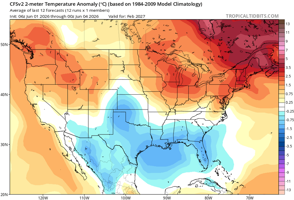
-
impressive to see Logan sustaining an 81 on a SE 9 kt wind
-
Yeah, sucks. We all wanted heavy rain
-
are you talking about the front, or the thunderstorm triggering - i suppose you could get that pre frontal quasi dry-line trough thingy in that situation. That would actually be ahead of the better synoptic support - which I would not ever side with the NAM on synoptic timing dude. Just don't ...
-
Give me 25-30 higher
-

2026-2027 Strong/Super El Nino
snowman19 replied to Stormchaserchuck1's topic in Weather Forecasting and Discussion
-
82.0/46 Would like these dews 15 higher
-
2026-2027 Strong/Super El Nino
mitchnick replied to Stormchaserchuck1's topic in Weather Forecasting and Discussion
Like I said, December ain't so bad. Here are temps. https://www.tropicaltidbits.com/analysis/models/?model=cfs-mon®ion=us&pkg=T2ma&runtime=2026060400&fh=6 February and definitely March look better taking into consideration seasonal temps for the period. But as I said, entertainment purposes at this point. https://www.tropicaltidbits.com/analysis/models/?model=cfs-mon®ion=us&pkg=T2ma&runtime=2026060400&fh=8 https://www.tropicaltidbits.com/analysis/models/?model=cfs-mon®ion=us&pkg=T2ma&runtime=2026060400&fh=9 -
I am buying the NAM timing...the NAM is usually the model which is a bit too slow. Heights really fall too mid-to-late afternoon, even on the GFS. That too me signals leaning faster with timing (well one reason)


.thumb.gif.f92b16c631a1d15d405ed77b33f0710d.gif)


