All Activity
- Past hour
-

“Cory’s in NYC! Let’s HECS!” Feb. 22-24 Disco
ineedsnow replied to TheSnowman's topic in New England
GFS also has another big one Friday -

“Cory’s in NYC! Let’s HECS!” Feb. 22-24 Disco
The 4 Seasons replied to TheSnowman's topic in New England
The GFS machine is nearly identical, mostly noise if anything. GFS is a tick west and more robust. 15-30 region wide except N/NW MA berks cuts off sharply -
Ralph, I too, woke up to go pee BUT, did more than I bargained for, IN MY BED, after reading your initial NAM “poo” post… THANKS‼️
-

“Cory’s in NYC! Let’s HECS!” Feb. 22-24 Disco
moneypitmike replied to TheSnowman's topic in New England
Last night's 6" brings me to 65" for the season. I'll probably finish around average (80-isih) while this storm will make many in SNE score the winter as an A+. -
I'll be hitting the grocery store here in Harrington before the peeps wake up and realize what's coming.
-
Maaan it feels like we are gonna get unlucky with this thing and watch it slip off to the NE while we caught in between with rates not quite enough with the marginal temps. I'd love to be wrong, but looking at 6z so far and the 0z Euro and AI? Starting not to feel it...
-
-
“Cory’s in NYC! Let’s HECS!” Feb. 22-24 Disco
The 4 Seasons replied to TheSnowman's topic in New England
I mean you're the glass half full king you stay pessimistic but we love it. We do, uh, have rather big storm on our hands.. -
The nam was still snowing here lmao
.thumb.png.24eea71c3fb1fc277c3e1c3d6c8f1d3f.png)
-

“Cory’s in NYC! Let’s HECS!” Feb. 22-24 Disco
codfishsnowman replied to TheSnowman's topic in New England
I'd really like to see some more purple across west central and Western Mass and parts of eastern New York. This qpf cut off is vomit worthy.... We're going to have to have some deform magic or its ar tic sand and pictures from the south and east to look at I don't know if I have ever seen the models hammar home valley deficits so intensely before....every model has it so its got to be right. -
6z gfs is noise level change im terms of track. However it did cut back totals a smidge. How far west that CCB gets is going to cause chaos. Verbatim with kutchera, western Berks get 7" and eastern gets 2 ft lol. Sent from my SM-S938U using Tapatalk
-
remote learning school..
-
Congrats up there. This reminds me of something from the '07-'08 playbook.
-
“Cory’s in NYC! Let’s HECS!” Feb. 22-24 Disco
moneypitmike replied to TheSnowman's topic in New England
Serious question here: How would anyone make accurate accumulation measurements with this wind? I'd think it'll be an exercise in futility. -

“Cory’s in NYC! Let’s HECS!” Feb. 22-24 Disco
H2Otown_WX replied to TheSnowman's topic in New England
When I called the winter a ratter, January 25th happened. When I said more whiffs and cold rain, this storm came back from the dead. I guess I'll just say something pessimistic and that ensures we get a KU. -
“Cory’s in NYC! Let’s HECS!” Feb. 22-24 Disco
moneypitmike replied to TheSnowman's topic in New England
a couple tenths of that in the 128 area are from prior to the storm. The 48-hour totals will control for that. -
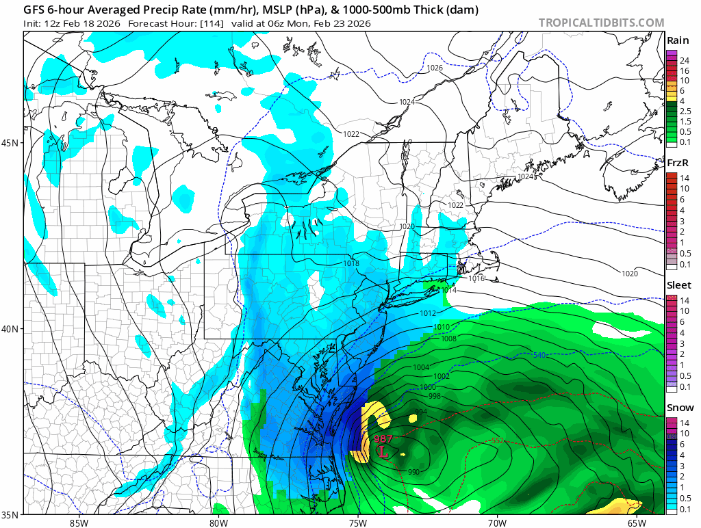
Appears guidance is converging on a solution now somewhere between the CMC and the GFS camps. Euro being the extreme eastern/least snowy outlier and the NAM being the extreme on the opposite side. Pretty much what @Newman and I have been talking about for a couple of days with Central DE to S NJ and shore points being the bullseye and points N and W still a MECS thru SE PA. If Im guessing right now at this hour, 'around a foot' seems a reasonable call imby in Warminster/Ivyland. My folks in Cape May otoh....1-2' easy.
-
“Cory’s in NYC! Let’s HECS!” Feb. 22-24 Disco
moneypitmike replied to TheSnowman's topic in New England
Yup. My earlier post was that the low's placement had reached it's northern limit--the qpf field would still vary. -
“Cory’s in NYC! Let’s HECS!” Feb. 22-24 Disco
moneypitmike replied to TheSnowman's topic in New England
Good Lord. -
Last 3 days of gfs runs Imagine it's wrong lol

-
“Cory’s in NYC! Let’s HECS!” Feb. 22-24 Disco
ineedsnow replied to TheSnowman's topic in New England
Woof!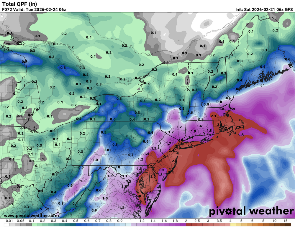
-
“Cory’s in NYC! Let’s HECS!” Feb. 22-24 Disco
ineedsnow replied to TheSnowman's topic in New England
Qpf is actually better.. EOR going to get destroyed -
6z gfs has more snow in NYC than 0z
.thumb.png.2b7442a5e1f024611bb6b2992cb3512b.png)
-
I was just going to post this, Wow!
-
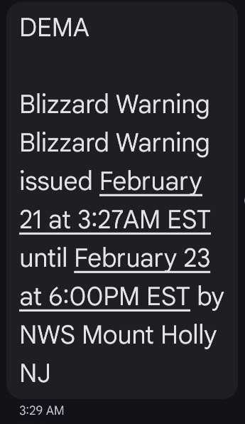
Nothing like waking up this this morning to a text messages, of a Blizzard Warning. First time I every received a text message like that.


.png.100abe20aa839b503903057bf20745ee.png)


.png.2abf289ea0f7a51f1f7d487b22766f27.png)


