All Activity
- Past hour
-

"Don’t do it" 2026 Blizzard obs, updates and pictures.
weatherwiz replied to Ginx snewx's topic in New England
102K w/o power in NJ -
Not gonna lie, this one stings. Knowing what is just 50 miles to our west. Also the rug pull that was the last 24 hours of modeling for western spots. We may have 4" or 5". Can't even tell if it's still snowing by looking at the street lights. Roads are just wet lol. Stoked for those of you getting raked. Ill live vicariously through you guys. That band over Philly has got to be amazing. Enjoy! Sent from my SM-S938U using Tapatalk
-

"Don’t do it" 2026 Blizzard obs, updates and pictures.
Roger Smith replied to Ginx snewx's topic in New England
Nantucket 54SE buoy reports ENE 43 kt g 54 kt, 38F, 29.83" and 18' wave heights ... the deepening (!) low will track just south of that location in about six or seven hours. That would suggest the 50-60 mph winds will be pushed up over southeast MA around that time, and could increase to 60-70 mph. There are going to be some brutal conditions in eastern MA, RI and se CT between now and about noon, If you don't already have this bookmarked, here you go ... NDBC - Station 44008 Recent Data -
Thanks! I guess we'll see how it goes. I have to back in off of Koffel Road which is dicey when it's dry and the sun shines. Not sure what it'll be like today.
-

"Don’t do it" 2026 Blizzard obs, updates and pictures.
ineedsnow replied to Ginx snewx's topic in New England
Recon out.. maybe we can get a actual pressure reading on this thing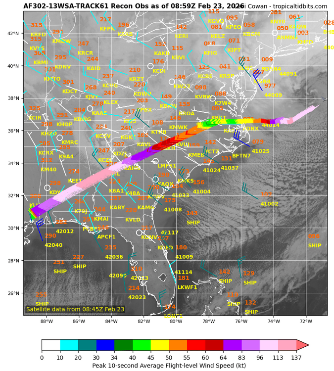
-

"Don’t do it" 2026 Blizzard obs, updates and pictures.
BIsound replied to Ginx snewx's topic in New England
RI south coast. Power out at 3:30am. Shoveled around generator. RI Energy text says 1600 impacted in my area -

"Don’t do it" 2026 Blizzard obs, updates and pictures.
The 4 Seasons replied to Ginx snewx's topic in New England
yeah we've been torch-erd here watching New London and Middlesex get smoked with 18-30" storms over and over the past 10 years.

-
"Don’t do it" 2026 Blizzard obs, updates and pictures.
Thunderblizzard replied to Ginx snewx's topic in New England
Getting hard with everything blowing and drifting now... going with 9.5" as of 4:00 AM. Blizzard conditions. -

"Don’t do it" 2026 Blizzard obs, updates and pictures.
CoastalWx replied to Ginx snewx's topic in New England
Sick band there -

"Don’t do it" 2026 Blizzard obs, updates and pictures.
Ginx snewx replied to Ginx snewx's topic in New England
A couple hrs ago I saw 14 plus in LHV -

"Don’t do it" 2026 Blizzard obs, updates and pictures.
Kitz Craver replied to Ginx snewx's topic in New England
Holy blizzard -
METAR KEWR 230851Z 35026G39KT 1/2SM R04R/4500VP6000FT -SN BLSN BR FEW006 OVC013 M01/M02 A2951 RMK AO2 PK WND 36047/0807 SFC VIS 3/4 SLP992 SNINCR 1/14 P0000 60004 T10111022 55030 $ METAR KJFK 230851Z 36031G41KT 1/2SM R04R/2400V3000FT SN BLSN FZFG VV007 M01/M02 A2944 RMK AO2 PK WND 35043/0814 SLP967 SNINCR 1/12 P0002 60004 T10111017 56038 $
-
"Don’t do it" 2026 Blizzard obs, updates and pictures.
Ginx snewx replied to Ginx snewx's topic in New England
4am look outside its light but it's a white out so awesome -
"Don’t do it" 2026 Blizzard obs, updates and pictures.
The 4 Seasons replied to Ginx snewx's topic in New England
That band over NJ/LHV just been rotting all night..gif.d40ea29f3a2c2b574e714fb7955788d2.gif)
-

"Don’t do it" 2026 Blizzard obs, updates and pictures.
tiger_deF replied to Ginx snewx's topic in New England
Thinking of taking a strategic map, for BOS what’s an estimate for timing the peak of the storm? HRRR seems to think maybe in the ballpark of 8 AM? -
"Don’t do it" 2026 Blizzard obs, updates and pictures.
CoastalWx replied to Ginx snewx's topic in New England
Dude I really hope you do. You and Seymour. -
"Don’t do it" 2026 Blizzard obs, updates and pictures.
Ginx snewx replied to Ginx snewx's topic in New England
9 in super band incoming -
That’s @Birds~69 territory. Spotter reported 11” 2 hours ago in willow grove which is near by. I’d guess they have at least a foot
-
"Don’t do it" 2026 Blizzard obs, updates and pictures.
The 4 Seasons replied to Ginx snewx's topic in New England
yeah im thinking i have my first shot at seeing a 20 burger. Thinking in the neighborhood of 18" which is the middle of our range, well see. -
I agree. I didn’t loose power for Sandy, and for more than a couple hours at any time that I’ve been at this location in the past 25 years. That said, hope I haven’t jinxed myself.
-
"Don’t do it" 2026 Blizzard obs, updates and pictures.
tiger_deF replied to Ginx snewx's topic in New England
A few miles west of the city, we barely cracked an inch an hour ago. But the pace has picked up markedly the past half hour and the wind is howling -

"Don’t do it" 2026 Blizzard obs, updates and pictures.
WinterWolf replied to Ginx snewx's topic in New England
Long way to go too…amazing out there. -
"Don’t do it" 2026 Blizzard obs, updates and pictures.
The 4 Seasons replied to Ginx snewx's topic in New England
Bust. F winter -
"Don’t do it" 2026 Blizzard obs, updates and pictures.
weatherwiz replied to Ginx snewx's topic in New England
winds starting to pick up here and howl a bit -
Allright, help me out guys. How much snowfall had there been in the Lansdale/Hatfield area? I have to go down there around noon to 1pm to deliver Lucerne Dairy on Forty Foot Road.