
All Activity
- Past hour
-

Occasional Thoughts on Climate Change
LibertyBell replied to donsutherland1's topic in Climate Change
I never considered July 1936 to be such a hot outlier. For the middle of the country maybe but not really outside of the farming belt. 1936 was a one heatwave wonder for those of us on the East Coast and represents the folly of ranking summer months by average temperatures. From that sane period 1944 was a much hotter summer. Just take a look at how many 100 degree days there were and how far north they got. Burlington VT set their all time high of 101 that summer. If you connect together all the 11 year cycle summers beginning with 1911 you see that they stand out for exceptional extreme heat. -
Occasional Thoughts on Climate Change
LibertyBell replied to donsutherland1's topic in Climate Change
The human overpopulation problem is the main causative factor in climate change and pollution and everything else being discussed. Following the herd doesn't lead to a good outcome. It's why the planet was so much cleaner during the pandemic. And yes dirttiness predates ACC but ACC itself is the result of pollution that humanity has been known for since the industrial age began. You seem a bit too defensive to be objective about the self destructive nature of humanity. -
That 100 degrees at Riverhead from 1997 is shocking. How did Riverhead hit 100 degrees that summer but no part of the city did?
-
No it really does not LOL. We regularly get 90 degrees to about the middle of September. You have August confused with October. And even October isn't all that cool anymore. Make it November. Also why would anyone want to rush in cold weather? I'd rather not shell out a thousand dollars a month in heating costs, thanks.
-
I think it might be showery for the meteor shower peak tonight unfortunately. Maybe it will clear out later so I'll be up around 3 am and go outside on my bedroom balcony to look. That's supposed to be the best time anyway.
-
 india online pharmacy [url=https://trustpharmaindia.com/#]Trust Pharma India[/url] pharmacy website india
 -
http://trustpharmaindia.com/# Trust Pharma India
-
000 SXUS71 KILN 112056 RERDAY RECORD EVENT REPORT NATIONAL WEATHER SERVICE WILMINGTON OH 0454 PM EDT TUE AUG 11 2026 ...RECORD DAILY MAXIMUM RAINFALL SET AT DAYTON OH... A RECORD RAINFALL OF 2.07 INCHES WAS SET AT DAYTON OH TODAY. THIS BREAKS THE OLD RECORD OF 1.86 INCHES SET IN 1915. $$ Not even halfway though the month, we're already at 4.78" for the month so far.
- Today
-
2026-2027 Record-breaking El Nino
BlizzardWx replied to Stormchaserchuck1's topic in Weather Forecasting and Discussion
I suppose that will be the question this fall, when this actually happens. It's probably going to be gradual as baroclinity increases, and my guess would be not much change from now until the back half of September. Could be pretty nasty in my area until then if we stay stuck under the heat dome. -
https://trustpharmaindia.com/# top online pharmacy india
-
indian pharmacy: indian pharmacies safe - Trust Pharma India
-
 September has weak ENSO correlations, historically. It really picks up in October.
 -
https://trustpharmaindia.com/# Trust Pharma India
-
https://mexisaferx.shop/# mexican online pharmacy wegovy
-
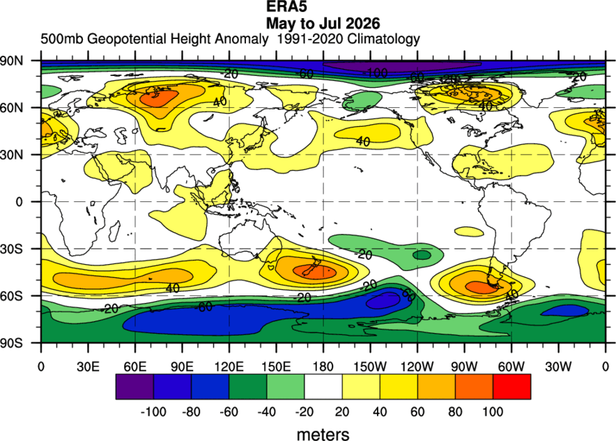
 Looking through each year individually some years rhyme but you can't expect a 1:1 situation. 1991, 2015, 2023 stuck out the most as being similar to the northern hemisphere pattern we are currently seeing in the 3 month interval.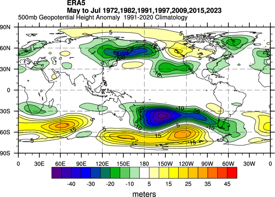
-
Invest 92L: 0Z UKMET: only makes it to TD status for the first time in many runs:NEW TROPICAL CYCLONE FORECAST TO DEVELOP AFTER 24 HOURSFORECAST POSITION AT T+ 24 : 10.6N 40.2WLEAD CENTRAL MAXIMUM WINDVERIFYING TIME TIME POSITION PRESSURE (MB) SPEED (KNOTS)-------------- ---- -------- ------------- -------------0000UTC 13.08.2026 24 10.6N 40.2W 1011 231200UTC 13.08.2026 36 11.4N 42.5W 1012 270000UTC 14.08.2026 48 11.5N 46.5W 1012 301200UTC 14.08.2026 60 12.5N 49.9W 1013 280000UTC 15.08.2026 72 13.6N 54.3W 1012 301200UTC 15.08.2026 84 14.2N 58.8W 1012 290000UTC 16.08.2026 96 CEASED TRACKING
-
Central Tropical Atlantic (AL92): Showers and thunderstorms are showing some signs of organization in association with a tropical wave located around 700 miles southwest of the Cabo Verde Islands. Environmental conditions are forecast to be conducive for development during the next few days, and a tropical depression will likely form within a couple of days while the system moves westward to west-northwestward across the central tropical Atlantic. * Formation chance through 48 hours...medium...60 percent. * Formation chance through 7 days...high...80 percent.
-
The only noticeable thing is the increase in moisture across my region specifically, still not enough to break the drought fully but working on it. The Caribbean has exceptional shear right now which is pretty typical of Nino (they are also below 30N so more in tune with what I had stated in my last post. There is quite an abundance of shear in that region that even areas of the East Pacific are being affected by this from about southern Mexico to Panama. Here are the 500mb patterns for MJJ leading into the strong to super Nino category based on RONI (since this is what we are using now). https://www.cpc.ncep.noaa.gov/products/analysis_monitoring/enso/roni/ I was reluctant to use 2023-24 since in RONI terms was only a moderate Nino (borderline strong) and comparing it to this year so far. There are some similarities this year to those past years in the southern hemisphere but overall the northern hemisphere seems to be opposite.
-
Mosquitoes survive extreme northern winters because their eggs or adult females enter a state of dormant animation called diapause, allowing them to freeze solid without dying. Built-in Antifreeze: Mosquitoes produce glycerol and chemical compounds that lower the freezing point of their bodily fluids, preventing lethal ice crystals from destroying their cells. Insulating Snow Blanket: Mosquitoes overwinter beneath thick layers of snow, leaf litter, or in animal burrows. The snow acts as insulation, keeping ground temperatures much warmer than the -40°F air temperature. The Egg Strategy: Most northern mosquitoes belong to the Aedes genus. They lay eggs in dry soil before winter. These eggs are incredibly resilient, remaining completely dormant until spring. When the massive winter snowpack finally melts, the water cannot drain into the ground because the soil underneath is permanently frozen (permafrost). This creates millions of shallow, stagnant pools of water perfect for mosquito breeding. Combined with 24 hours of summer sunlight that warms the water rapidly, billions of eggs hatch all at once, creating the infamous "Arctic mosquito swarms." So guys, if you going up North, bring those frying pans! You're gonna need them!
-
Thanks! It looks like Dec 1957 was +7.4 QBO and Strong Nino That's the only ONI>1.0, QBO>+6 analog pre-1979. Dec 1970 Mod Nina, -17 QBO. Sometimes strong -PNA patterns have prevailed in Dec in Nina/-QBO. I could see how this would have been cold if not for the massive Aleutian block - notice the +150dm -NAO. (QBO is Strat - so more AO connection).
-

2026-2027 Record-breaking El Nino
Jebman replied to Stormchaserchuck1's topic in Weather Forecasting and Discussion
So it IS true we are seeing some influence from the Nino in the CONUS? This link is interesting. https://atlas.niu.edu/gwo/ -
A ton of rain tonight and much more coming. A very nice surprise this evening and tonight to pick up several inches of rainfall.
-
https://psl.noaa.gov/data/correlation/qbo.data goes back to 1948 monthly at just 30mb but was done being updated with a lot of other things back at the end of February 2026. Also have this pdf from awhile back again unfortunately have not seen this updated in a long time https://www.geo.fu-berlin.de/met/ag/strat/produkte/qbo/qbo_wind_pdf.pdf Updated site for ^^^ https://www.atmohub.kit.edu/english/807.php
-
http://mapletrustrx.com/# canadian pharmacy 365
-

Augdewst 2026: Summer's Last Stand
vortex95 replied to Prismshine Productions's topic in New England
Pffttt! Lame X post. He does not specify how *strong* El Nino was those years. That makes a big difference. And there have been 10 El Nino events since 1994, so where are the other 7 for comparison? 2002-03 was strong El Nino. How did that winter do? /S 2009-10 was strong El Nino, what happened that winter? /S We should be looking at very strong El Ninos only. We've have 4 since the 1950s, 1982-83, 1991-92, 1997-98, 2015-16. It is a mixed bag, leaning toward below avg snowfall, but there was the Feb 1983 blockbuster and also Jan 2016. So it does not mean it is a complete loss. Also, sample size, 4 very strong El Ninos in 70 years does not tell us the full gamut of what can happen, so don't let the @CoastalWxDebbie Downer attitude rule here! There are no less than a dozen other global and regional oscillations going on and how they interact w/ El Nino can and does lead to the unexpected. Case in point, normally in very strong El Nino, Cali is soaked and the Pac NW is dry. Well, that did not occur in 2015-16, it was the exact opposite! Also, the wx/atmosphere does not work linearly. In other words, just b/c this may be the strongest El Nino in modern times, does not mean you simply extrapolate in one direction based off other very strong events, esp. when it comes to regional sensible wx and the specifics.





