All Activity
- Past hour
-
You know it's going to trend north at some point. We're really sitting good here.
-
And it's quicker coming in Friday night/Saturday am. Only 5 and a half days out...
-
AI models have almost a completely different alignment and evolution of hp over the top of this storm. Are they right? IDK. But deterministic modeling is almost uniformly placing more cold hp above or just to the NW of the system whereas the AI models quickly dissipate the hp over and behind the system. Are they right? IDK that either! The 12z Euro jogged south of its 18z run, and is a tick north of its 12z run. Pretty decent agreement w/ the three deterministic models. It is not surprising to see models jog north a bit. However, there remains a risk of suppression w/ this and even at the last minute if those big highs verify to the north and northwest of the storm and can persist longer than AI models depict. Important aspects still to be ironed out, but we are getting closer to a solution - maybe. As of now, we are potentially tracking a strong winter storm which will impact portions of the forum area. Nothing written in stone at this time, but we will see where this goes.
-
That panel is a thing of beauty from my perspective. Just wow
-
00z Euro is about 18 hours of light to moderate snow with no temp issues, and on a weekend. It's just beautiful.
-

January 25/26 Jimbo Back Surgery Storm
gamecockinupstateSC replied to Jimbo!'s topic in Southeastern States
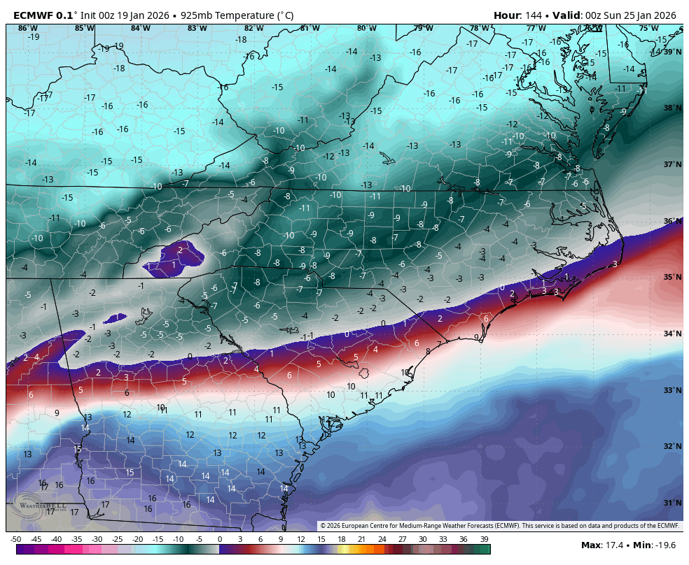
Hopefully with 925's like this it will be more sleet than FZR. Not good when Euro has had ice for days and is in lock step with the AI.
-
I love where we are at this juncture. The cold is almost always slightly over modeled at range. The only true way we get completely burned in this is congrats Carolina’s. I’d take a low that travels up to WV knowing with this antecedent airmass and wedge we’d lay down 6-12” in thumping fashion over to some high impact sleet/zr if that’s what it came to. Let’s reel this one in.
-
Eventually the whole forum area turns to snow except that sliver in SE TN and N Alabama.
-
Ouch
.thumb.png.e7dd33a2cb337a80f73bf59c68f35b81.png)
-
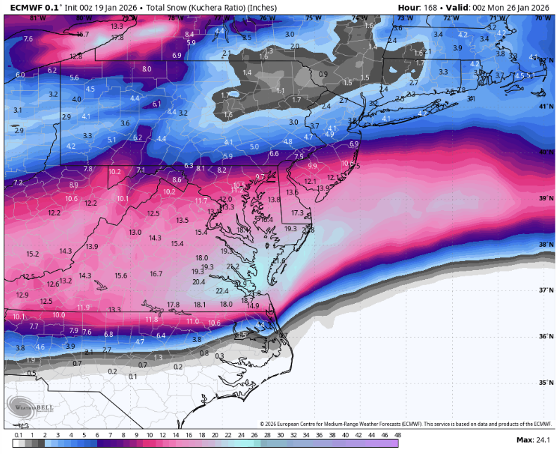
20:1 ratios baby

-
Almost exactly like the AIFS...
-
132 .
-
lol Sorry next time I’ll wait for my models to come out Next time tell us it’s a freaking foot lol
-
Euro is later with cold push and quicker with precip. Massive ice/sleet storm for most
-
That is kuchera though. Not to say the rates couldn’t be a little higher than 10:1 but like Bob said earlier, it’s pretty rare.
-

Winter cancelled/uncancelled banter 25/26
NorthShoreWx replied to Rjay's topic in New York City Metro
According to one source, Suffolk County is the 62nd snowiest county in the US (there are 3244 counties and parishes): https://lawnlove.com/blog/snowiest-counties/ Seems very unlikely to me. There are exactly 62 counties in NYS. There are exactly another 62 counties in VT, NH, ME, MA, & CT (plus 5 in RI, but I'm going with a 62 theme). All the same, I might add "62nd snowiest county in the US" to my sig just for shits and grins. It says so on the Internet. -
Ratios baby
-
The evolution of the HP is key. The GFS/GEM/Icon...the HP is anchored in the Midwest over the top of everything. The AIFS develops a banana HP, which is not exactly what you want in this scenario. A) it allows for a stronger LP to develop and Banana HP is one of the ingredients needed for Miller B's and Miller A/B Hybrids. If you want a true Miller A or overrunning event in the upper south an anchored HP is what you want not a banana.
-
The Euro is snow for most of the state, a bad ice storm along and south of 40 in East Tennessee that should change to snow.
-
Euro at 120 .
-
So I may have underestimated the Euro, we actually DO get a foot. Ji is happy now.
-
Parkton mesonet now colder than Bittinger. Nice.
-
Lost of similarities to the CMC at 114 John .
-
Euro at 108 .
-
We all want it to show a foot for us...but when you're homeless and somebody offers you a 2 br apartment and not a mansion, you don't fucking complain.


.png.420850d81ba42942752d59091b234edb.png)