All Activity
- Past hour
-
Just because coastal areas haven’t seen 100° heat since 2013, doesn’t take away from the record to historic heat experienced in our forum away from the sea breeze.
-
Nothing met the criteria in june for heatwave with 99 degree or higher reading.
-
we're just going for the 3 local airports plus the park to define historic
-

June 2025 discussion-obs: Summerlike
TheClimateChanger replied to wdrag's topic in New York City Metro
Yeah, I doubt there's ever been a case where the entire region was AOA 100F on the same date. -
MTP has a New England climate Chris. I'd argue for our 3 airports plus Central Park being enough.
-
Still lightly misting here
-
But if the heat is really extreme, it will hit 100+ by 12 noon like it did in 2010 and 2011. The sea breeze will come in after JFK etc have already hit 100+ I notice that JFK temps rise quickly in the morning on these kinds of days and the sea breeze only comes in after it's already over 100.
-
yup...miserable today. Not sure what time the rain started here but took the dog out around 6:30 AM and it was raining pretty good.
-
Then by that narrower definition our region hasn’t ever had an historic heatwave since MTP only made it to 98° back in 2011. Time Series Summary for MONTAUK AIRPORT, NY - Jun through Aug Click column heading to sort ascending, click again to sort descending. 1 2011 98 1 - 2006 98 0 - 2001 98 1 2 2010 96 1 - 1999 96 0 3 2002 95 5 4 2019 94 2 - 2005 94 0 5 2013 93 2
-
July 2010 is far preferable to any of this
-
Uhg, it’s been 60s and raining here all day.
-
https://phys.org/news/2025-06-planetary-linked-wild-summer-weather.html
-
Breaks in the clouds
-
Well, we are heading into the Solstice so shouldn’t be a surprise to anyone.
-
74.0
-
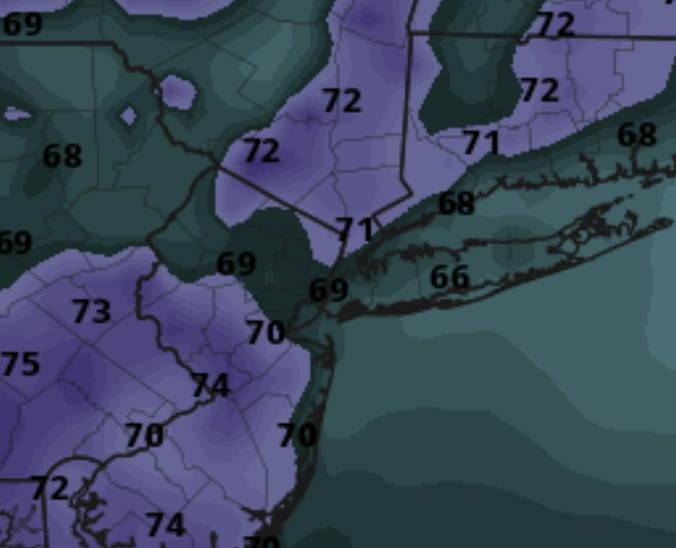
Same story on Tuesday, the worst dewpoints are mostly away from the coast despite the light seabreeze.
-
Nice nice deeper blue patches with the CU. We take today.
-
Some scenes from the flash flood emergency on Sunday:
-
It looks like more over the top heat, if the heat ridge was strong enough it would have kept the sea breeze away
-
If the ridge axis is to our west it makes it more likely the heat gets broken up by a backdoor front or T-storms. And there’s the southerly wind too that will try any day to factor in and cool it down. It’s just really tough to get these 5+ day big heatwaves especially the last 5 years or so.
-
It looks like the dewpoints are going to be bad. At the same time I said the GFS was giving us a bit of a SSE breeze on the coast on Monday, the dewpoints are actually worse where its's full roast inland:
-
We damp today.
-
It translated to the surface in June 2021 with all-time monthly high temperature records around NYC. EWR ranked #1 and LGA #2. Caribou tied their all-time June high in 2024 with the record Southeast Ridge year. Boston also tied their all-time June high in 2021 and ranked 3rd warmest last year. Time Series Summary for NEWARK LIBERTY INTL AP, NJ - Month of Jun Click column heading to sort ascending, click again to sort descending. 1 2021 103 0 2 2011 102 0 - 1994 102 0 - 1993 102 0 - 1952 102 0 - 1943 102 0 3 1988 101 0 - 1966 101 0 4 2024 100 0 - 1959 100 0 - 1953 100 0 - 1934 100 0 Time Series Summary for LAGUARDIA AIRPORT, NY - Month of Jun Click column heading to sort ascending, click again to sort descending. 1 2017 101 0 - 1952 101 0 2 2021 100 0 - 2008 100 0 3 1988 99 0 - 1956 99 0 - 1943 99 0 6 2012 98 0 - 1959 98 0 7 2024 97 0 - 2011 97 0 - 2003 97 0 - 1999 97 0 - 1994 97 0 - 1964 97 0 - 1961 97 0 - 1953 97 0 - 1945 97 0 Time Series Summary for Caribou Area, ME (ThreadEx) - Month of Jun Click column heading to sort ascending, click again to sort descending. 1 2024 96 0 - 2020 96 0 - 1944 96 0 2 2023 93 0 - 1995 93 0 - 1988 93 0 - 1983 93 0 3 2021 92 0 - 2003 92 0 - 1979 92 0 - 1963 92 0 Time Series Summary for Boston Area, MA (ThreadEx) - Month of Jun Click column heading to sort ascending, click again to sort descending. 1 2021 100 0 - 1952 100 0 - 1925 100 0 2 1933 99 0 3 2024 98 0 - 1988 98 0 - 1984 98 0 - 1953 98 0 - 1919 98 0 - 1874 98 0
-
Try Fahrenheit 451 too lol
-
no thank you, 100+ with 45 dewpoints is far better and far cleaner air.


.thumb.png.4150b06c63a21f61052e47a612bf1818.png)


