Yellow Evan Posted October 20, 2013 Share Posted October 20, 2013 Fwiw, last year the GFS kept showing a similar recurving hit on MX at about the same date and on numerous runs (Josh would recall) while the Euro never had anything. The Euro was victorious in that case. The GFS stopped showing these hits once it started emphasizing Sandy. I think Sandy messed all of that up, but I remember that clearly. The system ended up becoming Rosa. Link to comment Share on other sites More sharing options...
Yellow Evan Posted October 20, 2013 Share Posted October 20, 2013 Tico was further S. The change with the Euro is interesting, as all previous runs had this fishing. Let's see what happens on subsequent runs. https://en.wikipedia.org/wiki/File:Tico_1983_track.png Not by much, Tico still passed a bit north of Jalisco. Link to comment Share on other sites More sharing options...
Yellow Evan Posted October 20, 2013 Share Posted October 20, 2013 P.S. The new Euro run is what I'd call a classic October scenario, with a cyclone forming near the coast, moving slowly away, and then boomeranging sharply and rapidly toward the coast. Very classic indeed. I can make a long list of storm's that have done what you just described. Link to comment Share on other sites More sharing options...
HurricaneJosh Posted October 20, 2013 Share Posted October 20, 2013 Very classic indeed. I can make a long list of storm's that have done what you just described. Yeah. The last really sexy example was Kenna 2002, but there have been other lesser examples since. What's interesting is that while the GFS fishes Raymond, it seems to boomerang a future Sonia toward the coast after Day 10-- so both models are sniffing the boomerang setup, just with different cyclones. Link to comment Share on other sites More sharing options...
phil882 Posted October 20, 2013 Share Posted October 20, 2013 RI in progress... should be a hurricane by later tonight. Moreover the ECMWF has a very poor handle on the current intensification trends... I think the chances are increasing this makes landfall within 48 hours. Link to comment Share on other sites More sharing options...
Yellow Evan Posted October 20, 2013 Share Posted October 20, 2013 Yeah. The last really sexy example was Kenna 2002, but there have been other lesser examples since. What's interesting is that while the GFS fishes Raymond, it seems to boomerang a future Sonia toward the coast after Day 10-- so both models are sniffing the boomerang setup, just with different cyclones. Track-wise Rick 09 I'd say, but that weakened a bit into a TS before diving into Sinaloa. Link to comment Share on other sites More sharing options...
Yellow Evan Posted October 20, 2013 Share Posted October 20, 2013 RI in progress... should be a hurricane by later tonight. It could be one right now. Link to comment Share on other sites More sharing options...
GaWx Posted October 20, 2013 Share Posted October 20, 2013 Interesting. Honesty I don't remember. I think you're better at recalling these details than I. I think once a model tease doesn't materialize, those files just automatically delete from my head. Josh, I copied and pasted this from my 10/21/12 post (almost exactly one year ago!) showing a bunch of GFS runs in a row showing a hit (while the Euro had very little): "Here is the GFS update going through the 18Z GFS of today (14+ straight modeled strikes on MX): Thu 12Z: southern Sinaloa 11/2 Thu 18Z: southern Sinaloa 10/29 Fri 0Z: southern Baja Sur 10/31 moving ENE Fri 6Z: southern Baja Sur 10/29 moving NNE Fri 12Z: southern Baja Sur 10/29 moving NNE Fri 18Z: southern Sinaloa 10/30 moving NE Sat 0Z: Jalisco 10/31 moving NE Sat 6Z: northern Sinaloa 10/31 moving NE but unraveling Sat 12Z: southern Sinaloa 10/30 moving NE Sat 18Z: southern Sinaloa or northern Nayarit 10/29 moving NE or ENE Sun 0Z: northern Michoacan 10/29 unraveling? Sun 6Z: Jalisco 10/31 unraveling? Sun 12Z: Jalisco 10/31 unraveling? Sun 18Z: Colima 10/31 unraveling?" Also, from Josh, major H hits on west coast of Mexico since 1949: 1957 No. 10 (22 Oct) - Sinaloa - Cat 4 (120 kt) 1959 Great Mexico Hurricane (27 Oct) - Jalisco - Cat 5 (140 kt) 1967 Olivia (14 Oct) - Baja California Sur - Cat 3 (110 kt) 1975 Olivia (25 Oct) - Sinaloa - Cat 3 (100 kt) 1976 Liza (01 Oct) - Sinaloa - Cat 3 (~100 kt) 1976 Madeline (08 Oct) - Guerrero - Cat 4 (125 kt) 1983 Tico (19 Oct) - Sinaloa - Cat 3 (110 kt) 1989 Kiko (27 Aug) - Baja California Sur - Cat 3 (960 mb/100 kt) 2002 Kenna (25 Oct) - Nayarit - Cat 4 (950 mb/120 kt) 2006 Lane (16 Sep) - Sinaloa - Cat 3 (954 mb/110 kt) So hit dates were as follows: 8/27, 9/16, 10/1, 10/8, 10/14, 10/19, 10/22, 10/25, 10/25, 10/27 As Josh mentioned, the real strongest (cat. 4-5) hit mainly in late Oct.: 10/8, 10/22, 10/25, 10/27 Oncoming weak to moderate Ninos actually are the ENSO state since 1949 that has been the most favorable for the major MX hits (Liza, Madeline, Kenna, and Lane). 1957's #10 hit during an oncoming strong El Nino. -------------------------------- From me last year: "Also, I've found per Wiki three sig. hurricanes (any of which could have been a major at landfall) during the 1800's hitting between 10/27 and 11/1 on the MX coast anywhere from Mazatlan to Manzanillo: Nov. 1, 1839: Mazatlan, Sinaloa Nov. 1, 1840: San Blas, Nayarit Oct. 27, 1881: Manzanillo, Colima; 950 mb/110 knots..so this was a major; Per Wiki, 'This hurricane totally destroyed the city.'" So, lateness is key!! Also, Mazatlan in Sinaloa seems to be a magnet for late season major hits! Link to comment Share on other sites More sharing options...
Yellow Evan Posted October 20, 2013 Share Posted October 20, 2013 Josh, I copied and pasted this from my 10/21/12 post (almost exactly one year ago!) showing a bunch of GFS runs in a row showing a hit (while the Euro had very little): "Here is the GFS update going through the 18Z GFS of today (14+ straight modeled strikes on MX): Thu 12Z: southern Sinaloa 11/2 Thu 18Z: southern Sinaloa 10/29 Fri 0Z: southern Baja Sur 10/31 moving ENE Fri 6Z: southern Baja Sur 10/29 moving NNE Fri 12Z: southern Baja Sur 10/29 moving NNE Fri 18Z: southern Sinaloa 10/30 moving NE Sat 0Z: Jalisco 10/31 moving NE Sat 6Z: northern Sinaloa 10/31 moving NE but unraveling Sat 12Z: southern Sinaloa 10/30 moving NE Sat 18Z: southern Sinaloa or northern Nayarit 10/29 moving NE or ENE Sun 0Z: northern Michoacan 10/29 unraveling? Sun 6Z: Jalisco 10/31 unraveling? Sun 12Z: Jalisco 10/31 unraveling? Sun 18Z: Colima 10/31 unraveling?" Also, from Josh, major H hits on west coast of Mexico since 1949: 1957 No. 10 (22 Oct) - Sinaloa - Cat 4 (120 kt) 1959 Great Mexico Hurricane (27 Oct) - Jalisco - Cat 5 (140 kt) 1967 Olivia (14 Oct) - Baja California Sur - Cat 3 (110 kt) 1975 Olivia (25 Oct) - Sinaloa - Cat 3 (100 kt) 1976 Liza (01 Oct) - Sinaloa - Cat 3 (~100 kt) 1976 Madeline (08 Oct) - Guerrero - Cat 4 (125 kt) 1983 Tico (19 Oct) - Sinaloa - Cat 3 (110 kt) 1989 Kiko (27 Aug) - Baja California Sur - Cat 3 (960 mb/100 kt) 2002 Kenna (25 Oct) - Nayarit - Cat 4 (950 mb/120 kt) 2006 Lane (16 Sep) - Sinaloa - Cat 3 (954 mb/110 kt) So hit dates were as follows: 8/27, 9/16, 10/1, 10/8, 10/14, 10/19, 10/22, 10/25, 10/25, 10/27 As Josh mentioned, the real strongest (cat. 4-5) hit mainly in late Oct.: 10/8, 10/22, 10/25, 10/27 Oncoming weak to moderate Ninos actually are the ENSO state since 1949 that has been the most favorable for the major MX hits (Liza, Madeline, Kenna, and Lane). 1957's #10 hit during an oncoming strong El Nino. -------------------------------- From me last year: "Also, I've found per Wiki three sig. hurricanes (any of which could have been a major at landfall) during the 1800's hitting between 10/27 and 11/1 on the MX coast anywhere from Mazatian to Manzanillo: Nov. 1, 1839: Mazatlan, Sinaloa Nov. 1, 1840: San Blas, Nayarit Oct. 27, 1881: Manzanillo, Colima; 950 mb/110 knots..so this was a major; Per Wiki, 'This hurricane totally destroyed the city.'" So, lateness is key!! Also, Mazatlan in Sinaloa seems to be a magnet for late season major hits! You c/p'd the same thing from last year's thread like a month ago on here, BTW, Link to comment Share on other sites More sharing options...
GaWx Posted October 20, 2013 Share Posted October 20, 2013 You c/p'd the same thing from last year's thread like a month ago on here, BTW, I know. I'm sort of giving it a hard bump now that we're coming up on the crucial time. Link to comment Share on other sites More sharing options...
phil882 Posted October 20, 2013 Share Posted October 20, 2013 It could be one right now. Well NHC took it up to 60 knots in their most recent advisory, with 85 knots in 24 hours. The discussion sounds like they are growing more concerned about a landfall < 48 hours. Tropical Storm Warnings / Hurricane Watches have been hoisted up across the coastline near Acapulco. Start making your plans Josh, I think things are about to get very interesting. Link to comment Share on other sites More sharing options...
HurricaneJosh Posted October 20, 2013 Share Posted October 20, 2013 Well NHC took it up to 60 knots in their most recent advisory, with 85 knots in 24 hours. The discussion sounds like they are growing more concerned about a landfall < 48 hours. Tropical Storm Warnings / Hurricane Watches have been hoisted up across the coastline near Acapulco. Start making your plans Josh, I think things are about to get very interesting. This seems like it would be a tough chase subject, as it'll be very close to the coast by the time landfall seems imminent. But if it takes more of a Euro-type track-- moving away from the coast and then boomeranging back towards it-- that could work. Link to comment Share on other sites More sharing options...
phil882 Posted October 20, 2013 Share Posted October 20, 2013 Link to comment Share on other sites More sharing options...
Yellow Evan Posted October 20, 2013 Share Posted October 20, 2013 Looking more and more like a hurricane. 8th hurricane of the year here we come! Link to comment Share on other sites More sharing options...
Supercane Posted October 20, 2013 Share Posted October 20, 2013 If Raymond makes landfall as a hurricane, this would be the first EPAC season since 1997 with 3 hurricane landfalls. Link to comment Share on other sites More sharing options...
Yellow Evan Posted October 21, 2013 Share Posted October 21, 2013 If Raymond makes landfall as a hurricane, this would be the first EPAC season since 1997 with 3 hurricane landfalls. Not counting Ioke's landfall on Jonhston I'd assume in 2006. Also, unless you count Linda on Soccoro (did not make landfall there), 1997 only had 2. Nora and Pauline. 1996 had like 4 though. Link to comment Share on other sites More sharing options...
Supercane Posted October 21, 2013 Share Posted October 21, 2013 Not counting Ioke's landfall on Jonhston I'd assume in 2006. Also, unless you count Linda on Soccoro (did not make landfall there), 1997 only had 2. Nora and Pauline. 1996 had like 4 though. Don't forget Rick in 1997. And no, I'm not counting CPAC landfalls. Link to comment Share on other sites More sharing options...
Yellow Evan Posted October 21, 2013 Share Posted October 21, 2013 Don't forget Rick in 1997. And no, I'm not counting CPAC landfalls. Right. Forgot about Rick 97. Overshadowed by the Pauline. Underrated EPAC storm. Link to comment Share on other sites More sharing options...
snowmanwx Posted October 21, 2013 Share Posted October 21, 2013 Storms generally don't remain as stationary as NHC projects for Raymond over that period. They wander slightly off course. So Raymond easily could produce hurricane-force winds onshore somewhere, even if he doesn't make landfall. Moreover, terrain interaction will take its toll if Raymond gets his wind field sufficiently close to the coast, so he may fall apart before or without full-scale landfall. That said, I encourage you to activate the chase team. At the moment, infrared imagery suggests faster northward motion than the Hurricane Center forecast; that trend would bring the center somewhat closer to the coast. Barbara and Manuel struck the Pacific coast of Mexico earlier this season as bona fide hurricanes, but Ingrid collapsed before washing ashore from the Atlantic basin. Link to comment Share on other sites More sharing options...
wxtrackercody Posted October 21, 2013 Share Posted October 21, 2013 Eye is clearing out. Link to comment Share on other sites More sharing options...
Yellow Evan Posted October 21, 2013 Share Posted October 21, 2013 Storms generally don't remain as stationary as NHC projects for Raymond over that period. They wander slightly off course. So Raymond easily could produce hurricane-force winds onshore somewhere, even if he doesn't make landfall. Moreover, terrain interaction will take its toll if Raymond gets his wind field sufficiently close to the coast, so he may fall apart before or without full-scale landfall. That said, I encourage you to activate the chase team. At the moment, infrared imagery suggests faster northward motion than the Hurricane Center forecast; that trend would bring the center somewhat closer to the coast. Barbara and Manuel struck the Pacific coast of Mexico earlier this season as bona fide hurricanes, but Ingrid collapsed before washing ashore from the Atlantic basin. I don;t chase, but I get the sense it will moved quicker than expected. Been a problem all season long IMO for the NHC, they've been showing system moving slower than they actually did, evidenced by Octave. Link to comment Share on other sites More sharing options...
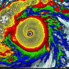
HurricaneJosh Posted October 21, 2013 Share Posted October 21, 2013 Storms generally don't remain as stationary as NHC projects for Raymond over that period. They wander slightly off course. So Raymond easily could produce hurricane-force winds onshore somewhere, even if he doesn't make landfall. Moreover, terrain interaction will take its toll if Raymond gets his wind field sufficiently close to the coast, so he may fall apart before or without full-scale landfall. That said, I encourage you to activate the chase team. At the moment, infrared imagery suggests faster northward motion than the Hurricane Center forecast; that trend would bring the center somewhat closer to the coast. I assume you were addressing this to me (Re: the chase team). It's certainly tempting, but there are so many variables at play and I've just gotten back from a triple-typhoon chase, so I'm maybe feeling a tad more conservative than normal. But it does look pretty awesome, particularly that MW image. I'll reassess tonight. Link to comment Share on other sites More sharing options...
Yellow Evan Posted October 21, 2013 Share Posted October 21, 2013 ATCF makes it 80 knots. Link to comment Share on other sites More sharing options...
icebreaker5221 Posted October 21, 2013 Author Share Posted October 21, 2013 Eye is clearing out nicely. BAMD continues to suggest that a deep system (as Raymond is rapidly becoming) would make landfall in about 24 h. That said, last few frames suggest that northward motion has slowed significantly. Could just be wobbles as the core continues to become better defined, or it could suggest that the southerly deep layer steering flow is not as robust as modeled. Need a few more IR images to say for sure. Link to comment Share on other sites More sharing options...
wxtrackercody Posted October 21, 2013 Share Posted October 21, 2013 Up to 100 mph. Forecast to reach 125 mph. Link to comment Share on other sites More sharing options...
Yellow Evan Posted October 21, 2013 Share Posted October 21, 2013 Raymond=insane. Josh, chase this! Link to comment Share on other sites More sharing options...
HurricaneJosh Posted October 21, 2013 Share Posted October 21, 2013 It's tempting, but I can't get past the fact that the global models-- and the NHC forecast-- keep it offshore. To chase this, I'd need to disregard all the most-reliable indicators. Link to comment Share on other sites More sharing options...
phil882 Posted October 21, 2013 Share Posted October 21, 2013 Link to comment Share on other sites More sharing options...
Amped Posted October 21, 2013 Share Posted October 21, 2013 Eh so much for the no majors futility streak. Raymond will need to get sheared fast for that to hold. What do you know the storm Josh opts of will turn out to be the hawtest storm in many years. Link to comment Share on other sites More sharing options...
wxtrackercody Posted October 21, 2013 Share Posted October 21, 2013 It's tempting, but I can't get past the fact that the global models-- and the NHC forecast-- keep it offshore. To chase this, I'd need to disregard all the most-reliable indicators. The GFS and ECMWF initialized terribly with the system. The NHC noted significant uncertainty in their forecast and stated it would not take much for this to come ashore. Go on. P.S. is it time to make a new thread? Link to comment Share on other sites More sharing options...


Recommended Posts
Archived
This topic is now archived and is closed to further replies.