NorthArlington101
-
Posts
12,475 -
Joined
-
Last visited
Content Type
Profiles
Blogs
Forums
American Weather
Media Demo
Store
Gallery
Everything posted by NorthArlington101
-

Outta gas and Outta Time: Early March Winter Storm finale
NorthArlington101 replied to Ji's topic in Mid Atlantic
RGEM looks like a general ~1" of snow before light icing -
Outta gas and Outta Time: Early March Winter Storm finale
NorthArlington101 replied to Ji's topic in Mid Atlantic
ICON - all the afternoon. Some FRZA overnight. All models have temps cold enough at the surface... precip seems to do enough wherever it falls for this to accumulate on the grass, at least. -
Outta gas and Outta Time: Early March Winter Storm finale
NorthArlington101 replied to Ji's topic in Mid Atlantic
In all seriousness, my one takeaway from the early mostly-joke mesos is that they try to be snow with that second portion at the start. That would be a good trend. -
Outta gas and Outta Time: Early March Winter Storm finale
NorthArlington101 replied to Ji's topic in Mid Atlantic
Since this is kind of a joke event, why not randomly post the ARW control. We can dream! -
Outta gas and Outta Time: Early March Winter Storm finale
NorthArlington101 replied to Ji's topic in Mid Atlantic
We’ll see lol. Took the initial band a little north but essentially a copy/paste of 18z as the final result.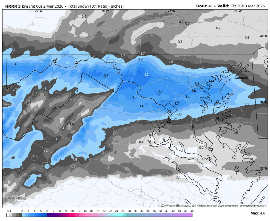
-
Outta gas and Outta Time: Early March Winter Storm finale
NorthArlington101 replied to Ji's topic in Mid Atlantic
Nice improvement from 12z. Seeing a wetter trend for sure. Also norther. Could be a “congrats Parkton” if it continues but it’s been a while so that’s okay. Would appreciate any and all snow TV on tap -
Late February/Early March 2026 Mid-Long Range
NorthArlington101 replied to WxUSAF's topic in Mid Atlantic
I think we’ve got at least one window in us after the thaw. We’re overdue April snow to some extent too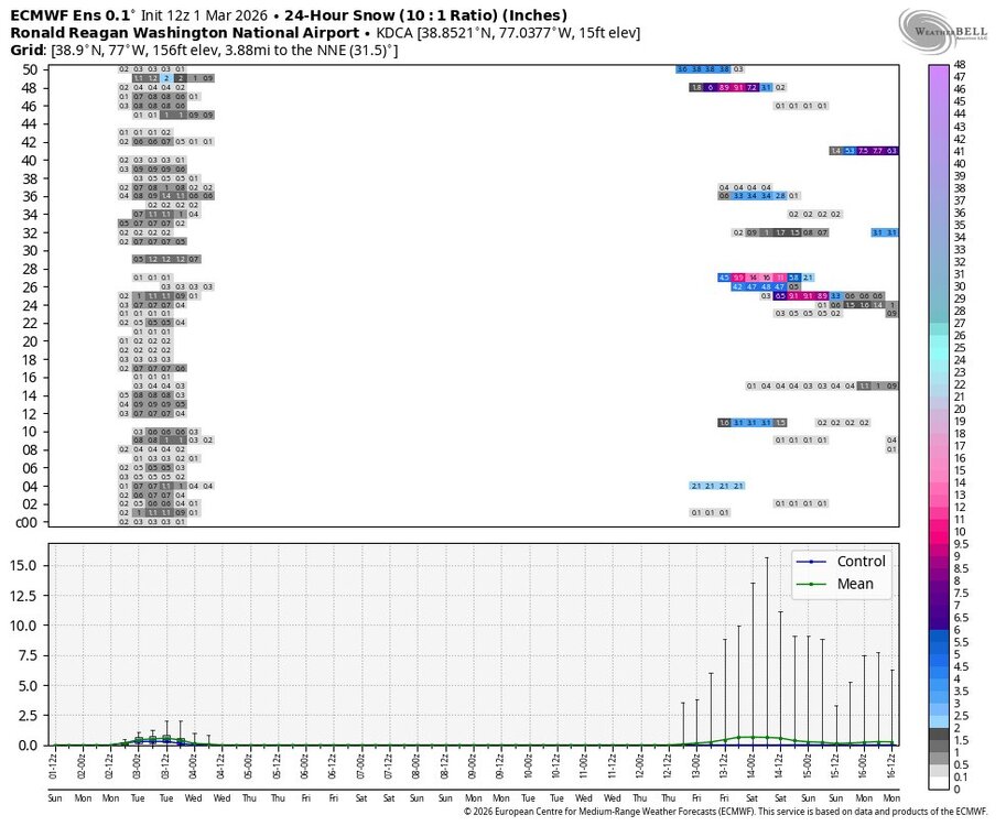
-
Outta gas and Outta Time: Early March Winter Storm finale
NorthArlington101 replied to Ji's topic in Mid Atlantic
Some freezing rain west of I-95 -
Outta gas and Outta Time: Early March Winter Storm finale
NorthArlington101 replied to Ji's topic in Mid Atlantic
I mean, idk, seems like it’ll snow a little tomorrow afternoon. Hopefully it’s a lil scenic out.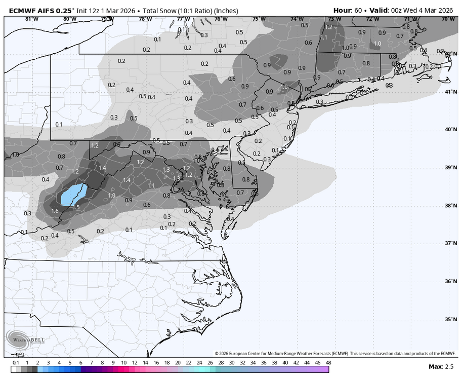
-
Outta gas and Outta Time: Early March Winter Storm finale
NorthArlington101 replied to Ji's topic in Mid Atlantic
Someone order a clown map?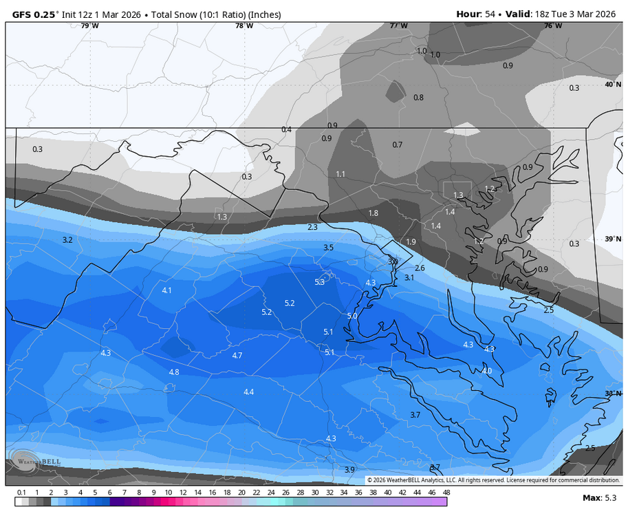
-
Outta gas and Outta Time: Early March Winter Storm finale
NorthArlington101 replied to Ji's topic in Mid Atlantic
Not expecting much but I think people are ignoring this because they are done with winter. Most models showing a period of at least light snow Monday afternoon before a pause and mix-y stuff into Tuesday morning. Kinda doubt I see anything in the city but .5-1” for folks doesn’t seem unreasonable… ignoring the plausible glaze of ice. -
Outta gas and Outta Time: Early March Winter Storm finale
NorthArlington101 replied to Ji's topic in Mid Atlantic
GFS also is wintry enough to keep an eye open at -
Outta gas and Outta Time: Early March Winter Storm finale
NorthArlington101 replied to Ji's topic in Mid Atlantic
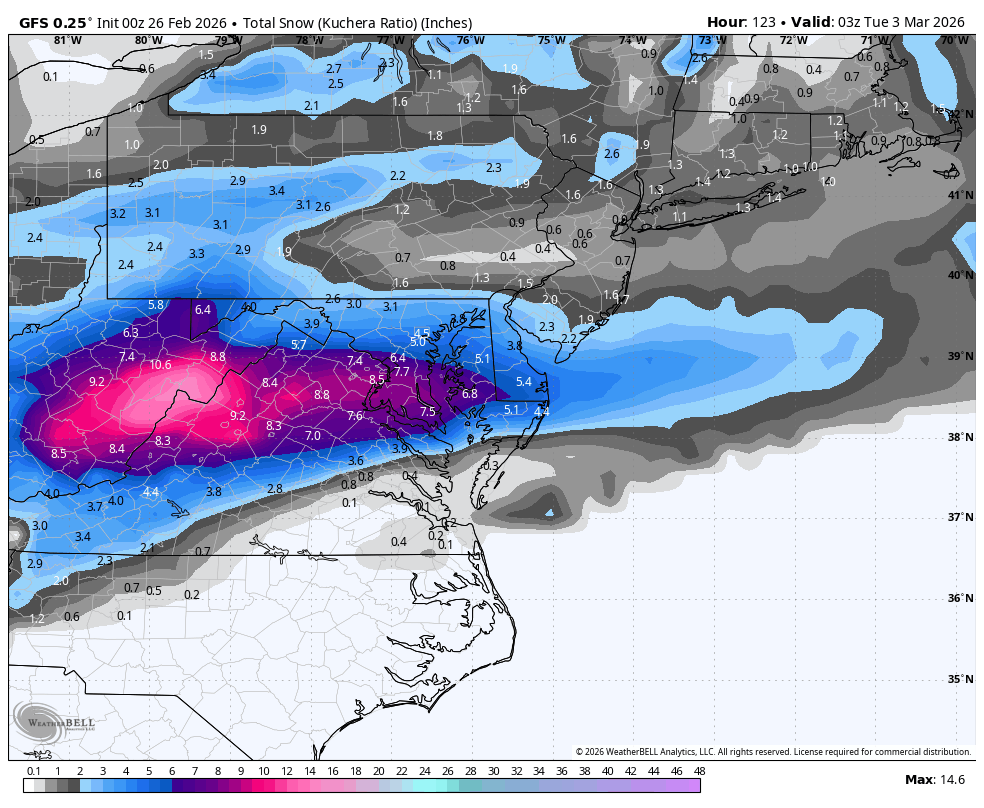
GFS as advertised is an interesting event… just a little too far south. Was norther with the real slug of precip though. -
Outta gas and Outta Time: Early March Winter Storm finale
NorthArlington101 replied to Ji's topic in Mid Atlantic
It’s been fairly consistent with a 3-5” hit somewhere. Usually over us. Can’t be a bad thing -
Outta gas and Outta Time: Early March Winter Storm finale
NorthArlington101 replied to Ji's topic in Mid Atlantic
I think the broader point is that verification scores aren’t gonna translate to specific areas for specific events… just not how it works. You can take or leave them as how a model performs if you want to but it’s kinda the only objective measure And it’s correct to say the AIFS was first to ID a big east coast storm. It was just wrong for us. But thr GFS was even more wrong! -
Outta gas and Outta Time: Early March Winter Storm finale
NorthArlington101 replied to Ji's topic in Mid Atlantic
EURO AI good. Dunno if I’ll make it to the normal one. Stormtracker is on his own
-
Outta gas and Outta Time: Early March Winter Storm finale
NorthArlington101 replied to Ji's topic in Mid Atlantic
I must say this was an off run anyway - def a lot less put together of a storm. Little precarious -
Outta gas and Outta Time: Early March Winter Storm finale
NorthArlington101 replied to Ji's topic in Mid Atlantic
Looks fine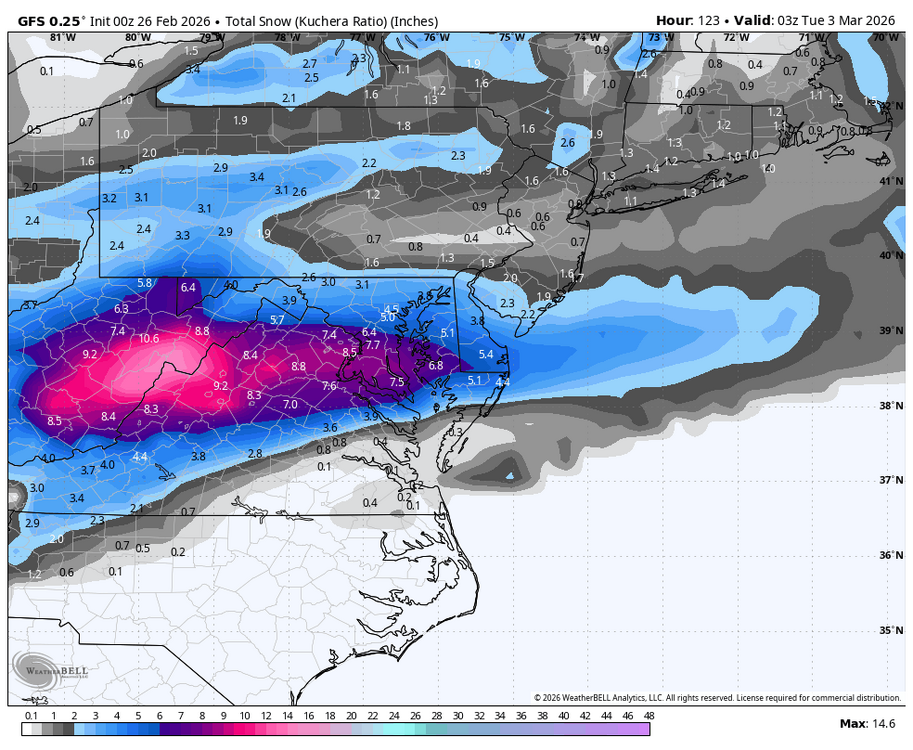
-
Outta gas and Outta Time: Early March Winter Storm finale
NorthArlington101 replied to Ji's topic in Mid Atlantic
This before FRZA. Not awesome but I’d take it
-
Outta gas and Outta Time: Early March Winter Storm finale
NorthArlington101 replied to Ji's topic in Mid Atlantic
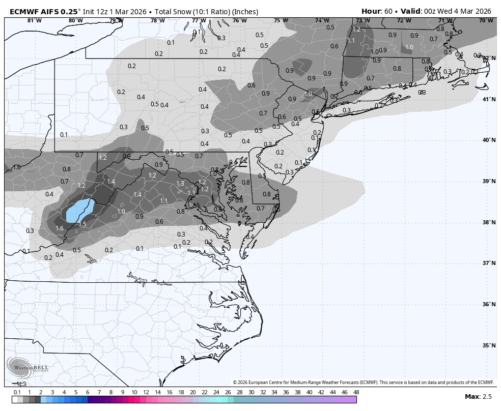
AIFS stubbornly south - nada for us; little bit for Central VA -
2/26 - Follow-up Hopium Battlezone Storm
NorthArlington101 replied to DDweatherman's topic in Mid Atlantic
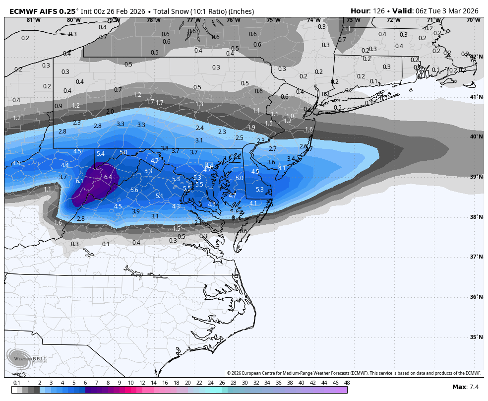
EURO also looking like a partial cave to the GFS - least a step in the right direction. dont get too excited - best panel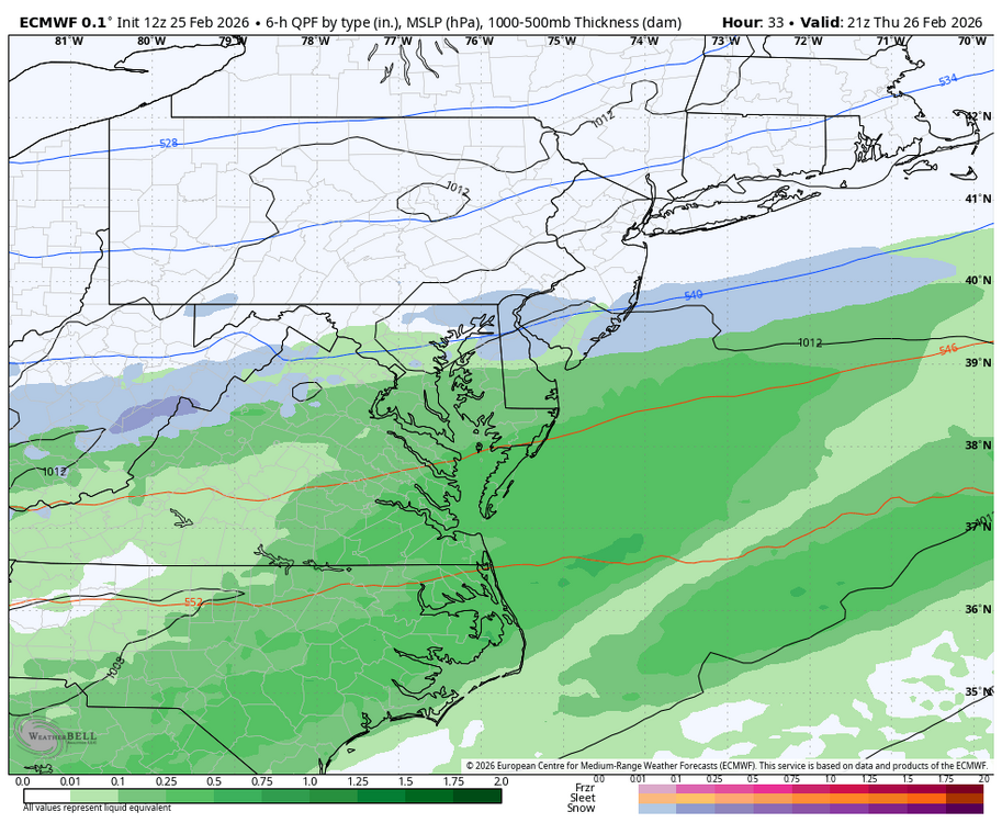
-
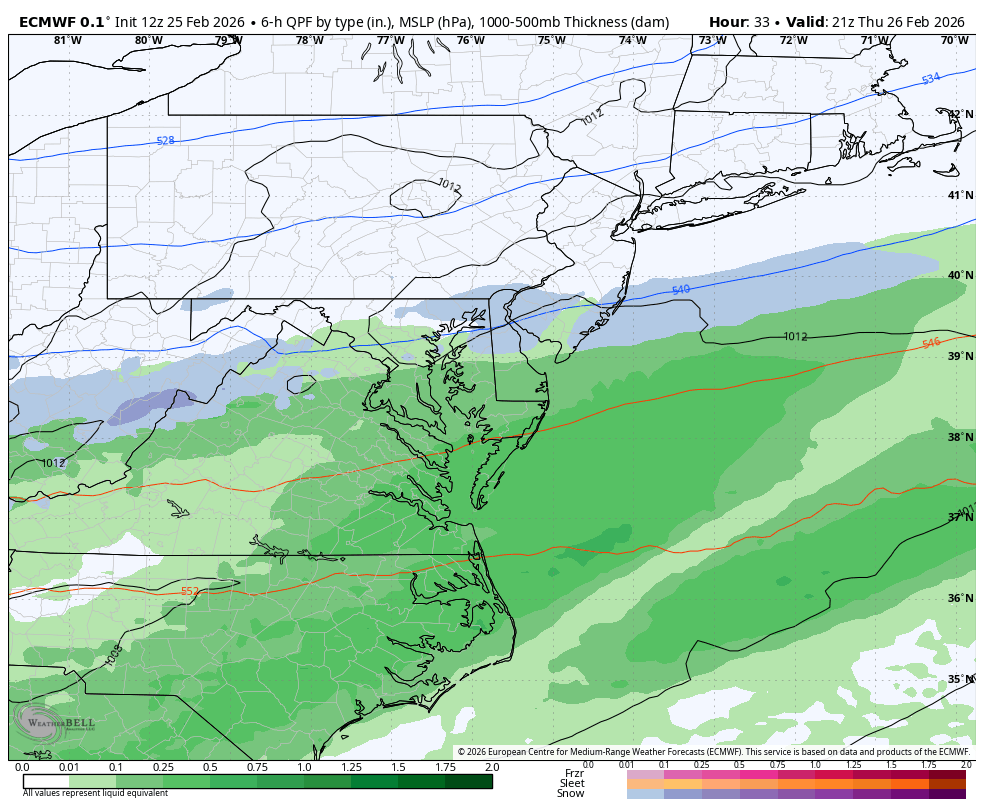
2/26 - Follow-up Hopium Battlezone Storm
NorthArlington101 replied to DDweatherman's topic in Mid Atlantic
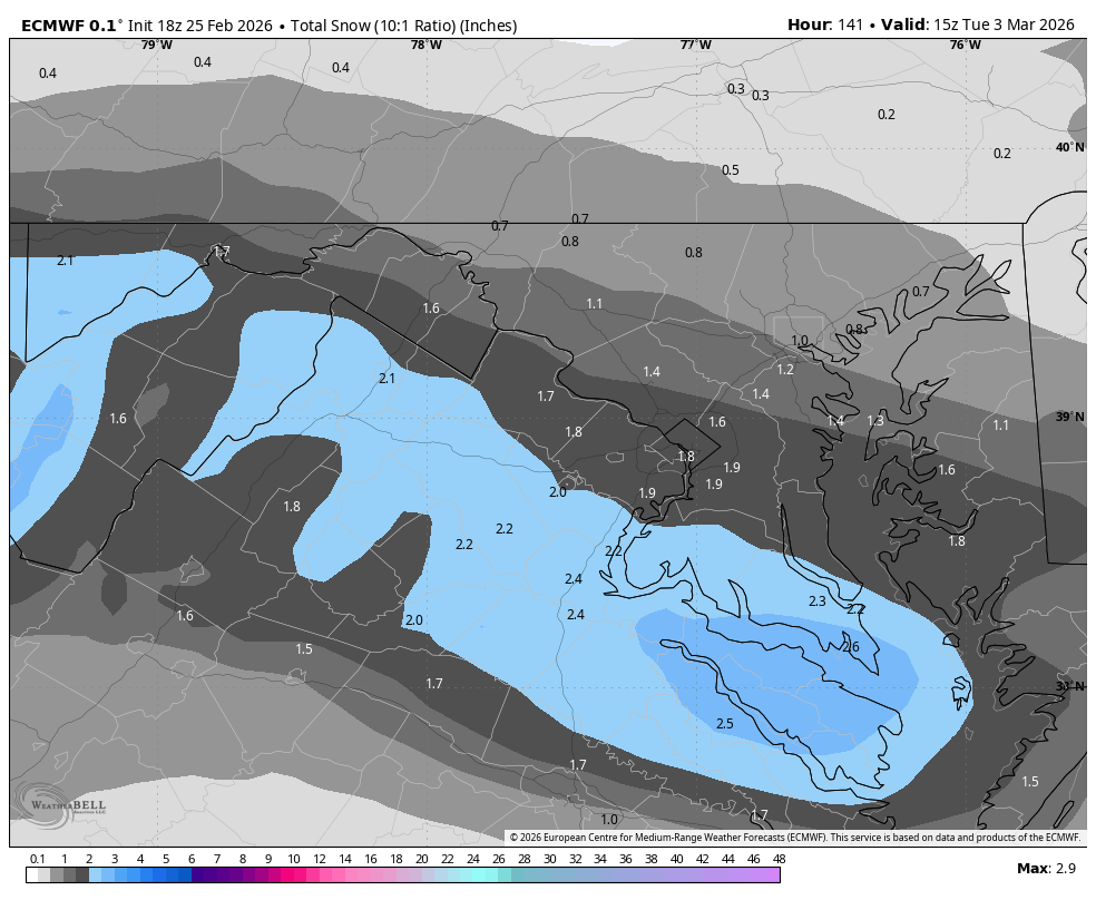
AIFS took a little leap north but as far as WxBell depicts the ptype its not snow -
Outta gas and Outta Time: Early March Winter Storm finale
NorthArlington101 replied to Ji's topic in Mid Atlantic
Overnight timing is really critical for March events. Sun angle is a real thing, unfortunately. Nothing we can do about it though -
Outta gas and Outta Time: Early March Winter Storm finale
NorthArlington101 replied to Ji's topic in Mid Atlantic
About the 6th straight run of a south trend on the GFS. Can probably stop soon. -
Outta gas and Outta Time: Early March Winter Storm finale
NorthArlington101 replied to Ji's topic in Mid Atlantic
Hits us with both waves. Probably the best outcome - unless you can squeeze more juice out of them, of course